Archive for the ‘railroad’ Category
darkness and silence

– photo by Mitch Waxman
As mentioned in yesterday’s post, a humble narrator has been spending some time and effort in pursuit of filling in a lack of nocturnal photographs in my library of Newtown Creek shots. While in the midst of this on the Greenpoint Avenue Bridge, just last week, I heard the bells and whistles signaling the approach of a NY & Atlantic freight train.
The thing kind of snuck up on me, as my headphones were actively pumping out a carefully selected playlist of mid-career Motörhead. Lemmy Kilmeister, you must understand, is far louder than any mere locomotive.

– photo by Mitch Waxman
These are the sort of “night shots” which I’m trying not to get. High ISO, selectively focused, and overly grainy- all of which was actually unavoidable. Simply put, if you’re “hand holding” the camera and it’s dark, one must open the lens up- losing deep focus- and increase the “ISO sensitivity” of the camera, which introduces grain. Ideally, you’ve got the thing on a tripod, which I didn’t.
My other camera was set up with specialized night gear, but there was no way to get it set it up in time when surprised by the sudden appearance of the train.

– photo by Mitch Waxman
Out came my dslr, and with the help of a fortuitously placed hole in the fence of the GPA Bridge, the camera could be steadied and these shots were gained. This is probably not a terribly exciting tale to relate, but every photographer will understand my frustrations. Digital cameras are a technology still in infancy, and the form factor and capabilities of the things are still influenced by the shape and metaphor of older devices which used chemical emulsions (film) for recording.
One is reminded of 1960’s and 70’s televisions built into cabinetry it shared with “hi-fi” stereos, or clock radios. When will we forget the metaphor of a film camera and allow these devices to flower into their own?
tones and accents

– photo by Mitch Waxman
Sauntering suspiciously through the hinterlands of Maspeth, along the malign fence lines of Rust Street, your humble narrator suddenly sensed a cacophony of ringing bells which occluded all reason. Assuming that one of my states was coming on, those hours of panic and terror brought on by a weakened constitution and the numerous afflictions which plague me, my first instinct was to monitor both pulse and temper.
Suddenly I realized that this ringing in my ears, now accompanied by a clattering and approaching ruckus, heralded the nearness of a train!
Note: Train folks, if you’ve got anything to say or link to regarding the actual model of locomotive, please use the comments link for this post. Every time a train photo is displayed here, I get at least a couple of emails telling me something cool about the locomotive. Please share, and leave a comment.
A
from wikipedia
Tinnitus can be perceived in one or both ears or in the head. It is usually described as a ringing noise, but in some patients, it takes the form of a high-pitched whining, electric buzzing, hissing, humming, tinging or whistling sound, or as ticking, clicking, roaring, “crickets” or “tree frogs” or “locusts (cicadas)”, tunes, songs, beeping, sizzling, sounds that slightly resemble human voices or even a pure steady tone like that heard during a hearing test. It has also been described as a “wooshing” sound, as of wind or waves. Tinnitus can be intermittent, or it can be continuous, in which case it can be the cause of great distress. In some individuals, the intensity can be changed by shoulder, head, tongue, jaw, or eye movements.

– photo by Mitch Waxman
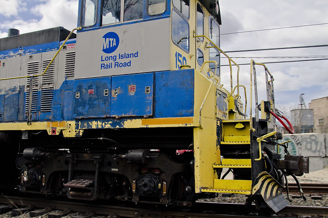
This was once one of the busiest stretches of rail in New York, let alone the United States. The Long Island Railroad (in its various guises, incarnations, and corporate forebears) have maintained their “road” here since the 1860’s. A shame, these tracks are a shadow of their former self and it’s not all that frequently that one sees traffic along the route. Hurling myself across the busy truck route, your humble narrator quickly sprang onto that fence which vouchsafe the track from trespass and interference, and whipped out the camera and began clicking away.
from wikipedia
The LIRR chartered the New York and Jamaica Railroad on September 3, 1859, and a supplement to the LIRR’s charter passed March 12, 1860 authorized it to buy the NY&J and extend to Hunters Point. The LIRR carried through with the NY&J purchase on April 25, along with the purchase of a short piece of the Brooklyn and Jamaica at Jamaica, and the next day it cancelled its lease of the Brooklyn and Jamaica, but continued to operate over it. The Brooklyn Central and Jamaica Railroad, a consolidation of the B&J with the new Brooklyn Central Railroad, began operating from South Ferry over the top of the tunnel, along the B&J tracks to Flatbush Avenue, and south on the new Fifth Avenue Line in August 1860. The new line to Hunters Point was officially opened on May 9, 1861, with regular service starting May 10. A ferry connection (Hunter’s Point Ferry) was initially advertised to James Slip; connecting boats began running to East 34th Street Pier in October. he BC&J soon began operating horse cars over the old line from South Ferry, connecting with LIRR trains at Jamaica. The tunnel was closed off in December.
– photo by Mitch Waxman
This double engine was hurtling along, which was somewhat remarkable. When I do see trains along this route, 9 times out of 10 they are NY & Atlantic freight trains which lumber along at a fairly tepid pace compared to this blue and gold comet which roared past me. Sadly, a diminished capacity for joy and low threshold for excitation allow one to consider the witnessing of this passing locomotive to be the high point of the day. Juvenile in character despite advanced years, it does not take much to impress one such as myself.
from wikipedia
Federal regulators limit the speed of trains with respect to the signaling method used. Passenger trains are limited to 59 mph and freight trains to 49 mph on track without block signal systems. (See dark territory.) Trains without “an automatic cab signal, automatic train stop or automatic train control system” may not exceed 79 mph. The order was issued in 1947 (effective 31 Dec 1951) by the Interstate Commerce Commission following a severe 1946 crash in Naperville, Illinois involving two Chicago, Burlington & Quincy Railroad trains. Following the 1987 Chase, Maryland train collision, freight trains operating in enhanced-speed corridors have been required to have locomotive speed limiters to forcibly slow trains rather than simply alerting the operator with in-cab signals. The signal panel in the Maryland crash had been partially disabled, with a muted whistle and a missing light bulb.

– photo by Mitch Waxman
Undoubtedly, as these tracks lead toward the Long Island City yard- which offers connections to both Manhattan and the gargantuan Sunnyside Yard- it is impossible to speculate on their final destination, but these engines were headed to somewhere in Long Island City.
for more on the twisting trackways of the Montauk Cutoff, check out this trainsarefun.com page

– photo by Mitch Waxman
On the Queens side of the Newtown Creek, a loathsome flood plain typified by concreted devastation and the relicts of the industrial revolution, the Long Island Railroad has long been the proverbial “800 pound gorilla” and as such- goes wherever it wants to go.
For visual orientation to more familiar locales, notice that dagger in the heart of Queens- the Sapphire Megalith- embedded in the innocent soil of Court Square in LIC, or the distant Freedom Tower under construction in lower Manhattan.
from wikipedia
“800 pound gorilla” is an American English expression for a person or organization so powerful that it can act without regard to the rights of others or the law. The phrase is rooted in a riddle:
“Where does an 800 lb. gorilla sleep?”
The answer:
“Anywhere it wants to.”
Also,

Obscura Day 2012, Thirteen Steps around Dutch Kills
April 28th, 10 a.m.
Your humble narrator will be narrating humbly at this year’s Obscura Day event on April 28th, leading a walking tour of Dutch Kills. The tour is already half booked up, and as I’m just announcing it, grab your tickets while you can.
“Found less than one mile from the East River, Dutch Kills is home to four movable (and one fixed span) bridges, including one of only two retractible bridges remaining in New York City. Dutch Kills is considered to be the central artery of industrial Long Island City and is ringed with enormous factory buildings, titan rail yards — it’s where the industrial revolution actually happened. Bring your camera, as the tour will be revealing an incredible landscape along this section of the troubled Newtown Creek Watershed.”
For tickets and full details, click here :
obscuraday.com/events/thirteen-steps-dutch-kills-newtown-creek-exploration
approaching locomotive

– photo by Mitch Waxman
On Morgan Avenue in the ancient section of industrial Brooklyn, not far from the legendary heart of darkness which is the English Kills tributary of the Newtown Creek, there may be observed a rail crossing. Part of the so called LIRR Bushwick Branch, recent opportunities have allowed me to fill in a missing piece of the great puzzle.
from wikipedia
The Bushwick Branch, also called the Bushwick Lead Track, is a freight railroad branch that runs from Bushwick, Brooklyn, to Fresh Pond Junction in Queens, New York, where it connects with the Montauk Branch of the Long Island Rail Road. It is owned by the LIRR but operated under lease by the New York and Atlantic Railway, which took over LIRR freight operations in May 1997.

– photo by Mitch Waxman
By no means should it be inferred that any special knowledge of the history of street grade rail in Brooklyn is possessed by your humble narrator, as this is still a subject under study around Newtown Pentacle HQ. If you were to look left (or south west) while on Morgan Avenue and traveling northward, this is what you’d see, way back here in the Cripplebush.
from wikipedia
East Williamsburg is a name for the area in the northwestern portion of the borough of Brooklyn in New York City, United States, which lies between Williamsburg, Greenpoint, and Bushwick. Much of this area has been and still is referred to as either Bushwick, Williamsburg, or Greenpoint with the term East Williamsburg falling out of use until the 1990s. East Williamsburg consists roughly of what was the 3rd District of the Village of Williamsburg and what is now called the East Williamsburg In-Place Industrial Park (EWIPIP), bounded by the neighborhoods of Northside and Southside Williamsburg to the west, Greenpoint to the north, Bushwick to the south and southeast, and both Maspeth and Ridgewood in Queens to the east.
Although the City of New York recognizes East Williamsburg as a neighborhood, there are no official boundaries to East Williamsburg since the City only officially delineates Community Districts and Boroughs, not neighborhoods.

– photo by Mitch Waxman
Looking right, or north east, you’ll see what appears to be a locomotive right of way that terminates at a distant green wall. The Bushwick line has been explored by many others who are braver of heart than I, including Diego Cupolo and Forgotten-NY’s own Kevin Walsh. There’s a missing piece in their accounts (which to be fair, has been off limits to inspection by passerby for some time), however, which recent serendipity allows me to bring to you.
This is, after all, part of Newtown Creek.
from The Eastern District of Brooklyn By Eugene L. Armbruster, via google books
BEYOND THE NEWTOWN CREEK
In the olden times the lands on both sides of Newtown Creek were most intimately connected. County lines were unknown, the creeks were dividing lines between the several plantations, for the reason that lands near a creek were taken up in preference to others, and the creeks were used in place of roads to transport the produce of the farms to the river, and thus it was made possible to reach the fort on Manhattan Island.
The territory along the Newtown Creek, as far as “Old Calvary Cemetery” and along the East River to a point about where the river is now crossed by the Queensboro bridge and following the line of the bridge past the plaza, was known as Dutch Kills. On the other side of Old Calvary was a settlement of men from New England and, therefore, named English Kills. The Dutch Kills and the English Kills, as well as the rest of the out-plantations along the East River, were settlements politically independent of each other and subject only to the Director-General and Council at Manhattan Island, but became some time later parts of the town of Newtown.

– photo by Mitch Waxman
An obsession of mine, let’s just name it a calling, is to photograph every possible corner of the Newtown Creek watershed.
Challenging, most of the shoreline is under lock and key, and many parts of it are under strict supervision by security personnel and police authorities. The spot these shots were gathered from is even hazy ground, and although I never stepped on the tracks and stayed to the extreme sides of the pathway, I was probably violating a “no trespassing” rule which I wear on my sleeve.
The presence of graffiti and a largish homeless camp I know to exist back here made me feel that any rule against taking a look around is lightly enforced by the gendarme and the proverbial dice would be thrown.
Speaking of dice, a locally famous accident occurred on the Bushwick line back in 2004.
from ntsb.gov
LIRR 160 traveled about 1.2 miles on the Bushwick Branch, passing over seven passive highway/railroad grade crossings. The event recorder indicated that the locomotive traveled the total distance of about 11,692 feet (2.2 miles) in 16 minutes 9 seconds and reached a maximum speed of about 31 mph.
During the runaway, LIRR 160 struck an automobile at one grade crossing and pushed it several hundred feet. The two occupants of this vehicle sustained serious injuries and required hospitalization. At another grade crossing, the locomotive struck two more automobiles, resulting in serious injuries to their drivers, who also required hospitalization. Two trucks were parked along the tracks near another grade crossing. The locomotive struck the trucks and pushed them about 800 feet westward beyond the crossing before it stopped. One of the trucks was carrying welding supplies, including acetylene and oxygen cylinders; the cylinders were damaged during the accident and caused a fire. The trucks were unoccupied; however, employees of the trucks’ owner had to jump away from the track to avoid injury.
As LIRR 160 collided with the automobiles and trucks, the struck vehicles were propelled in different directions and struck other vehicles. As a result, the accident damaged five other vehicles and a backhoe.

– photo by Mitch Waxman
Speaking of graffiti, these puzzling bits of signage were observed on a well painted wall. Like the “God’s Gift to Pain” graffiti at the end of English Kills, however, they filled me with some nameless dread.
from wikipedia
The first recorded use of the A in a circle by anarchists was by the Federal Council of Spain of the International Workers Association. This was set up by Giuseppe Fanelli in 1868. It predates its adoption by anarchists as it was used as a symbol by others. According to George Woodcock, this symbol was not used by classical anarchists. In a series of photos of the Spanish Civil War taken by Gerda Taro a small A in a circle is visibly chalked on the helmet of a militiaman. There is no notation of the affiliation of the militiaman, but one can presume he is an Anarchist. The first documented use was by a small French group, Jeunesse Libertaire (“Libertarian Youth”) in 1964. Circolo Sacco e Vanzetti, youth group from Milan, adopted it and in 1968 it became popular throughout Italy. From there it spread rapidly around the world.

– photo by Mitch Waxman
The icon in the tree part of this illustration is meant to be an “anarchy” symbol, but to me it looked like some multi lobed eye, if you know what I mean. Weird things go on around here, and this is no safe place, even while the radiant attentions of the burning thermonuclear eye of god itself are shining down upon the poison shores of English Kills.
from wikipedia
The “three-lobed burning eye” is one of many manifestations of Nyarlathotep, a messenger of the Outer Gods, from fiction penned by H. P. Lovecraft. This particular manifestation is a huge bat-winged creature, with a burning tri-lobed eye. In Lovecraft’s story “Haunter of the Dark,” the character Robert Blake discovers a Shining Trapezohedron in a church steeple in Providence, RI, a place of worship for the Church of Starry Wisdom cult. Narrowly escaping an unseen horror released by the Trapezohedron, Blake realizes the horror can only travel in the dark. When a storm and power blackout envelop the city, he scribbles down his findings, concluding the story with his terrified record of what he can only glimpse of the approaching beast. “I see it– coming here– hell-wind– titan-blur– black wings– Yog-Sothoth save me– the three-lobed burning eye…”

– photo by Mitch Waxman
Speaking of English Kills, this is the rail bridge which the tracks of the Bushwick Branch utilize to cross over it. In the background of the shot is one of the largest CSO outfalls in New York City and behind that is an access a ride parking depot and Johnson Avenue.
This is what it looks like from the water, incidentally, and long have I desired to see the New York and Atlantic crossing it from this perspective.
from habitatmap.org
- Combined Sewer Outfall – Newtown Creek 015
- Address Johnson Ave., Brooklyn, NY
- Neighborhood Newtown Creek
- Owner/Occupant NYC DEP
- Location Details Combined Sewer Overflow Outfall NC-015:
- discharges 344.4M gallons per year into English Kills
- Tier 2 outfall
- Ranked 20 out of over 400 in terms of volume
- located at Johnson Ave

– photo by Mitch Waxman
The bridge, which I’ve always heard referred to as “The Montrose Avenue Rail Bridge” is found some 3.8 miles from the East River, and regains land on the eastern shore of English Kills. Notice the green gate visible in the shot above.
from bushwickbiennial.com
James Riker’s 1706 “Bushwicklands” were separated from the original het dorp site by the estuary wetlands that would evolve from a creek into fetid industrial transportation canals (from the Dutch kil, trans. “body of water”). As the old farms were surveyed and sold as city-block lots, area borderlands became an underbelly serving the 19th century constructions of the “English Kills Canals,” the “Town of Bushwick” to the south, and the westerly “Village of Williamsburgh.” Becoming an offal zone for breweries, slaughterhouses, & chemical manufacturing, glass, rope & bag factories, and coal, oil, & stone distribution: the flatland meadows and canal basins provided business opportunities for waves of 19th century Central European immigrants that was near, but away from, metropolitan domestic life down Bushwick Ave.

– photo by Mitch Waxman
Here is that same gate, from the perspective of the trackway. The property behind that gate is the Waste Management Varick Avenue site, which is pretty much off limits. The fabled garbage train begins its journey to the continent here, as the Varick Avenue facility handles much of the putrescent waste produced in Brooklyn.
from wikipedia
Waste Management, Inc. (NYSE: WM) is a waste management, comprehensive waste, and environmental services company in North America. The company is headquartered in Suite 4000 at the First City Tower in Downtown Houston, Texas, in the United States.
The company’s network includes 367 collection operations, 355 transfer stations, 273 active landfill disposal sites, 16 waste-to-energy plants, 134 recycling plants, 111 beneficial-use landfill gas projects and 6 independent power production plants. Waste Management offers environmental services to nearly 20 million residential, industrial, municipal and commercial customers in the United States, Canada, and Puerto Rico. With 21,000 collection and transfer vehicles, the company has the largest trucking fleet in the waste industry. Together with its competitor Republic Services, Inc, the two handle more than half of all garbage collection in the United States.

– photo by Mitch Waxman
Speaking of Waste Management, the serendipity mentioned above involved your humble narrator joining with a group of students on a tour of the facility, and this is what the rail bridge looks like from the other side of the gate.
Welcome to the unknown country.
from dot.ny.gov
Waste Management has a substantial waste transfer operation located on English Kills upstream from the Metropolitan Avenue Bridge, incorporating all of the east side of the English Kills from Ten Eyck Street to the LIRR bridge near the head of the creek, an area of 24.7 acres. Currently, Waste Management uses the site to transfer commercial and residential refuse to trucks and rail for transport to landfills in New Jersey, as well as to store and maintain their trucks.

– photo by Mitch Waxman
Another posting coming in the near future will discuss the interior workings of this place, but for now, here’s where the Bushwick branch tracks continue on their course. This is where the folks at Waste Management containerize and load up the “garbage train”.
from nytimes.com
For decades, as trash has made its way from transfer stations in Brooklyn to out-of-state landfills, it has been shuttled through the borough’s streets on ground-rattling, smoke-belching tractor trailers.
The result: irritated neighbors and polluted air.
On Wednesday, Mayor Michael R. Bloomberg unveiled a plan to replace those trucks with trains. The city will now transport tons of garbage out of Brooklyn via railroad, which will take thousands of trucks off the street.
Speaking at a trash transfer station in North Brooklyn — with a trash-filled train behind him — Mr. Bloomberg said that the change would eliminate about 13,000 truck trips a year, helping the city meet ambitious goals for cutting carbon emissions.

– photo by Mitch Waxman
The tracks continue northeast across the property, and towards Varick Avenue. They cross Varick at Grade, and continue on their winding course toward the Fresh Pond depot, crossing Flushing Avenue in Maspeth and meeting connections toward Long Island City not far from Rust Street. This Rust Street connection offers access to the tracks which follow Newtown Creek through West Maspeth, Berlin, Blissville, and terminate ultimately at Hunters Point. Once, they carried cargo all the way to the East River, where Gantry Docks loaded them onto float barges for delivery in Manhattan and beyond.
from prnewswire.com
While many people balk at taking out the trash, it’s a job that the New York & Atlantic Railway does gladly — hauling 1.7 million pounds of residential and municipal waste each day, destined to Dixie in sealed containers riding aboard extra-long flat cars.
Monday through Saturday, a NY&A train crew goes over to the Varick Avenue transfer station in East Williamsburg, Brooklyn, where they couple up with 10-to-12 89-ft. flat cars loaded with up to 48 22-ft. long containers. Each has been stuffed with 18 tons of refuse, collected from homes and businesses in North Brooklyn.
The Varick Avenue facility was redesigned recently to accommodate rail shipments. It is owned and operated by Waste Management Inc. — one of the nation’s leading transporters and processors of municipal waste. NY&A began test movements in late January and handled its first regular shipment on February 16, 2009.

– photo by Mitch Waxman
This is the view from inside the gates on the Varick side of the Waste Management property…

– photo by Mitch Waxman
And this is the reversed POV, shot through a gap in the fence on the sidewalk.

– photo by Mitch Waxman
The line continues on the other side of Varick, in the distance, you can see the Scott Avenue Footbridge.
This “trainsarefun.com” page offers detailed schematics and historic shots of the Bushwick line, which are certainly worth a moment of your time.
concealed fires

– photo by Mitch Waxman
A few interesting photos adorn today’s posting, progeny of the prodigious amount of exploration a humble narrator has been occupied with for the last couple of weeks. There are so many great things “in the works” which haven’t been publicly announced yet, and which I’m bursting at the seams to tell you about, that I’m all a twitter.
2012 promises to be one of the great years for you to see and experience the Newtown Creek for yourself, as the early stages of several walking and boat tours are in the works.
– photo by Mitch Waxman
In the last two weeks, I’ve walked the entire creek in pursuance of one of these projects, which will be finalized and made public quite soon. I’ve worn out a pair of shoes, and shot literally thousands of photos for this project. My path has carried me from Bushwick to Long Island City and Greenpoint to Maspeth.
I’ve dodged trucks and trains, violated perhaps three separate sets of legal restrictions, and encountered a vast coterie of characters both malign and inspirational.

– photo by Mitch Waxman
Within the next couple of weeks, announcements of many, many public events will begin. Meanwhile, the concrete devastations of Western Queens and the oil choked sands of North Brooklyn have been catalogued and categorized, concatenated and containerized.
It’s going to be a great summer.
graceful valleys

– photo by Mitch Waxman
A structure which may be discerned in the distance, within the shot above, at Sunnyside Yards is the 35th street or Honeywell Bridge. The location of the camera which captured it was astride the 39th street or Harold Avenue bridge at Steinway Street, where ongoing construction has rendered a hidden breach in the fencing which normally frustrates its purpose by obfuscating the view.
For a discussion of another of the bridges which cross these titan rail yards, click here for the posting “incaculable profusion”, examining the Thomson Avenue Viaduct to the west.
from forgotten-ny.com
When the Yards were built, Long Island City, to the north of the Yards, was effectively cut off from Sunnyside and Maspeth, to the south. Viaducts were built at Queens Boulevard (which was itself under construction in 1910), Honeywell Street, Harold Avenue, and Thomson Avenue. Laurel Hill Avenue (43rd Street) Gosman Avenue (48th Street) and Woodside Avenue were carried under the railroad.

– photo by Mitch Waxman
A paucity of such apertures in the fence lines around the yards exists, which is appropriate in this age of heightened vigilance, and the discovery of something large enough to accept the lens of a dslr is tantamount to observing a unicorn to one such as myself. Of course in the midst of all this faux security and theater, I can show you a dozen different places where you could work mischief if you chose to. Such is always the case with large installations like this one, however, and illegal trespass is not the Newtown Pentacle way.
The real estate happy characters in Manhattan are desirous to rob me of this vista, as evidenced in the document linked to below, describing the feasibility and benefits of decking over these yards and expanding the population of western Queens by tens of thousands. It seems to be a plan of some vintage, however, crafted before the financial crisis and concurrent economic crisis experienced by the region and country at large since 2008 (when do we get to start calling this a depression?).
from nyc.gov
Sunnyside Yards, one and three-quarters of a mile long and 1,600 feet across at its widest point, is the largest site in this inventory. The total deckable airspace of its 14 parcels – over 167 acres – is more than double the size of the next largest airspace site, the 74-acre NYCT Coney Island Maintenance Shop and Yards (K5000). This one corridor contains around one-sixth of the entire deckable airspace in this inventory.
The potential for large scale land uses above these yards is extraordinary. With the possible exception of Staten Island’s west shore, no other large tracts of “vacant” land remain in the City. Moreover, Sunnyside Yards is defined by a surrounding context of relatively dense development and plentiful transit access.
At the behest of former Deputy Mayor for Economic Development and Rebuilding Daniel Doctoroff, DCP’s Housing, Economic and Infrastructure Planning (HEIP) unit conducted a preliminary analysis concerning the viability of decking over and developing Sunnyside Yards. The HEIP unit determined that the most desirable sites within the yards were two roughly rectangular areas running from the southwest to the northeast; the northern third of both sites is located northeast of Queens Boulevard.

– photo by Mitch Waxman
These trusses which fly over the Sunnyside Yards are actually rather new. The Honeywell and Harold Bridges (39th and 35th streets), for instance, were totally rebuilt recently. The Honeywell Bridge reopened in 2003 after having laid fallow and closed to pedestrian and vehicle traffic for better than 20 years. The night shot above, by the way, is betrayed by its format and shape as being from my trusty old Canon G10, which is still in service at this- your Newtown Pentacle.
from nytimes.com
In 1979, inspectors from the city’s Department of Transportation judged the 1,600-foot four-lane bridge, which was built in 1909, to be on the verge of falling down. The inspection occurred near the end of an era in which the city, nearly broke and as exhausted as a disco dancer at dawn, partly balanced its budget by deferring maintenance on bridges. Tom Cocola, a department spokesman, said once costs had been cut by removing the bridge from the city’s regular inspection schedule, ”we probably just forgot about it.”


