Posts Tagged ‘New York City Skyline’
delighted astonishment
A short trip off of a Long Island to… Staten Island.

– photo by Mitch Waxman
Over at the St. George Ferry terminal, on the… Staten Island… side of the harbor, one is treated to magnificent views of Lower Manhattan and it’s a pretty sure bet that you’ll see some maritime traffic. Pictured above is the Vane Brothers Sassafras towing a fuel barge, for instance.
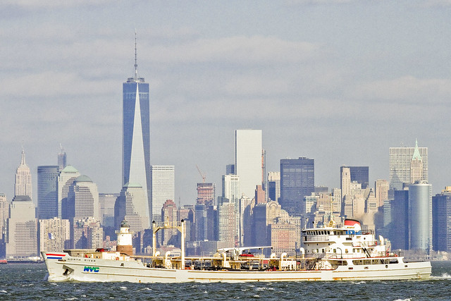
– photo by Mitch Waxman
One such as myself is always eager to witness a DEP Sludge Boat splashing by. That’s the MV North River heading towards the Port Richmond sewer plant found a mile or so up the Kill Van Kull.

– photo by Mitch Waxman
Marjorie B. McAllister also happened by, and the bright red tug was towing a fuel barge. Even when it seems that a tug is pushing a barge, it’s still called “towing.”
“follow” me on Twitter- @newtownpentacle
damnable chance
From the very edge of the Newtown Pentacle.

– photo by Mitch Waxman
The Cemetery of the Evergreens is found near the border of East New York and Bushwick, is some 225 acres in size, and is home to around a half million corpses. For a short time, during the 1920’s, it was the busiest burying ground in the entire city. Unfortunately, during my visit, the fact that Anthony Comstock is buried here was unknown to me, for I am possessed of a strong desire to first spread out a few issues of Hustler and thereupon urinate upon his grave. If that sounds shocking, you don’t know who that “assassin of joy” called Comstock was. If I’d known he was here, I’d have brought him some porn.

– photo by Mitch Waxman
Evergreens was my second destination on a recent trip to the south eastern interval of the Pentacle, after having visited Machpela Cemetery. When entering the place, a humble narrator was in a state of willful ignorance. My friend Kevin Walsh over at Forgotten-NY has written extensively (and offered a walking tour) about the non sectarian Cemetery of the Evergreens, btw., but this was my first visit. Personally, I was blown away by the view, as the altitude of the hill that the cemetery is built into offers panoramic views of the entire geologic “soup bowl” that NYC is nestled into. The only competition for these tapophile views from Bushwick, in my experience, are those encountered at the Mt. Olivet Cemetery found a few miles to the north over in Maspeth.

– photo by Mitch Waxman
It must be mentioned, as always, that the Manhattan people look to Brooklyn and Queens to dispose of things they don’t want – which includes their dead. Back in 1847, the Rural Cemeteries Act was passed as a sanitary law. The RCA of 1847, a reaction to a recent Cholera outbreak in Manhattan’s Bloody Sixth Ward, decreed that no new burials were to take place on Manhattan Island and that the various sects and houses of worship housed thereupon must acquire properties in “the country.” Back then, “the country” meant the vastness of greater Newtown or the infinity of the City of Brooklyn (independent municipalities, I would mention, who permanently lost a significant acreage of otherwise profitable land to these cemeteries).

– photo by Mitch Waxman
Observed were a wealth of monuments representing several recent eras in the field of graphic design. Particularly well represented were early 20th century deco and nouveau motifs, and typography such as that used on the carvings above was of high quality and tasteful execution. Having spent as much time studying First Calvary as I have, which hosts monuments that are the epitome of an interval starting during the Civil War of the 1860’s right through 1900 or so (thoroughly Irish and German Catholic in type and marker styling), this sort of “moderne” approach to funereal typography caught my eye. Several examples of this sort of marker were noticed, with the one above recorded simply because the light was good.

– photo by Mitch Waxman
For as long as this – your Newtown Pentacle – has been focusing on the various cemeteries which comprise the so called “Cemetery Belt” there have been references offered for “disturbing subsidences.” Presumption is made that you have a life and don’t spend your time hunting around cemeteries, unlike me, and that a little bit of explanation as to what you’re looking at should be attempted for the non ghoul.
This is a washout, not a fresh interment. If it was a new burial, there would be a temporary marker of some kind and the soil would form a slight mound – there would also be tire marks from earth moving equipment and footprints. Additionally, notice the edges of the bald soil! which bear the shape of flowing water. No, what you’re seeing here is a disturbing subsidence, wherein either the entire casket has been shifted or damaged by hydrologic action – or the lid of the casket has simply collapsed – allowing soil to infiltrate, creating a void which caused column of loam to drop down.
As mentioned – a “disturbing subsidence.”
“follow” me on Twitter- @newtownpentacle
later developments
“follow” me on Twitter at @newtownpentacle

– photo by Mitch Waxman
Just a quick one for Maritime Sunday this week, of the Marjorie B. McAllister tug steaming out of the Kill Van Kull. Iconic backgrounds notwithstanding, this is a pretty cool little boat, and deserving of a hearty “Hi.”
rhythmical promise
“follow” me on Twitter at @newtownpentacle

– photo by Mitch Waxman
Recently, occasion carried me down to Long Island City, where my stated goal was to catch the venerable East River Ferry and attend a meeting in Brooklyn Heights. It is somewhat ironic, to me at least, that the only mass transit pathway between two points on the western tip of Long Island that doesn’t involve transversing Manhattan is to use a ferry service set up to carry folks from the former to the latter. Unfortunately, just as I arrived at the dock, the boat was leaving, which in many ways is a metaphor for my entire life.

– photo by Mitch Waxman
It was no tragedy, as it offered an opportunity to linger and play around with some of that night photography I was talking about at the start of the week. Manhattan can be quite lovely when viewed from outside of itself, and some effort went into the endeavor. The Empire State Building, a shining beacon of hope erected during the deep despair of the Great Depression, never disappoints.

– photo by Mitch Waxman
For some reason, the Freedom Tower will always be the name I call the building at One World Trade Center. Future generations will just call it whatever name they inherit from us, and Freedom Tower reminds me of those early days of the Terror War when terms like “blowback”, “freedom fries”, and “new normal” were coined. I think it’s important to remember that time, and that some symbolism is valuable even for the jaded mindset of modernity.

– photo by Mitch Waxman
Such ruminations came to end, when the East River Ferry showed up. Their service has really matured in the last year, although the dock at Long Island City is in dire condition. It is temporary, of course, as the Hunters Point South development project surrounds and engulfs all in a shroud of ongoing construction.
perpetually ajar

– photo by Mitch Waxman
Recent serendipity found your humble narrator onboard a vessel plying the languid waters of the Newtown Creek. This particular adventure was part of a larger and laudable effort which will be the subject of a posting later in the week, but urgent demands and unavoidable deadlines preclude discussion of the outing at this point. Instead, one is anxious to share the scenic wonders and hidden landscape of this water body that defines the currently undefended border of Brooklyn and Queens.
Captured in the heart of DUMABO (Down Under the Metropolitan Avenue Bridge), the shot above depicts the far off and omnipresent Sapphire Megalith rising over industrial Brooklyn and framed by the Metropolitan Avenue Bridge while opening at English Kill.

– photo by Mitch Waxman
The self same Megalith again provides geographic context for the scene, and the thrice damned Kosciuszko Bridge and Calvary Cemetery occupy the foreground.
To the right is the Phelps Dodge site, and to the left is found the lurking fear and that rampant darkness which lurks on the Brooklyn side of DUKBO (Down Under the Kosciuszko Bridge Onramp).

– photo by Mitch Waxman
In the shot above, gaze in wonder at the skyline of the Shining City itself, as framed by the titan National Grid tanks and the myriad works of infrastructure arrayed across the Brooklyn flood plain. Inextricably linked, the heavy industries and energy installations along the Newtown Creek allow the Shining City to maintain the facade of assumptions which Manhattanites prefer to believe about this place where aspirant and realist metaphors clash.
More, on why exactly I was on this boat, will be forthcoming. Apologies for brevity and obfuscation.


