Existential scuttling
Tuesday

– photo by Mitch Waxman
Those old Christmas season cartoons – the stop motion animation ones from Rankin Bass – they had one heck of a sound track, if you ask me. The Heat/Cold Miser song, in particular, as well as the one from Santa’s origin story which bucked up the Winter Warlock’s mood by suggesting that if you ‘put one foot in front of the other, soon you’ll be walking out the door,’ are tunes that always seem to always actively dwell in my mind.
So does The Who’s ‘Don’t get fooled again’ but that ditty exists in a different mental folder.

– photo by Mitch Waxman
As mentioned in prior posts, the particular scuttle during which these shots were gathered wasn’t aimed at any one spot. I was straight up wandering, with intent revolving around getting from one T streetcar station on the north side of the Allegheny River to another one on the south side of the Monongahela River, via the peninsular ‘Downtown’ section of the Pittsburgh. Exploring, essentially.
I will admit to becoming somewhat intrigued by the flatiron shaped brick building pictured above, with its ornate lintels and terracotta decoration. I’m going to have to look into that one at some point.

– photo by Mitch Waxman
Pittsburgh’s Smithfield Street Bridge, over the Monongahela River, is fascinating to this NYC transplant. Well… beyond being how I got from one side of the river to the other, where the T station is.
The piers and masonry of the bridge were designed by none other than John Roebling (Brooklyn Bridge), and the steel upper section of the bridge was created by Gustav Lindenthal (Queensboro Bridge).
…put one foot in front of the other…
Back tomorrow.
“follow” me on Twitter- @newtownpentacle
Buy a book!
“In the Shadows at Newtown Creek,” an 88 page softcover 8.5×11 magazine format photo book by Mitch Waxman, is now on sale at blurb.com for $30.
Golden crossing
Monday

– photo by Mitch Waxman
As described last week, a humble narrator was taking one of those regular but quite existential ‘long walks,’ here in Pittsburgh. The scuttling motions were not following any particular design or desire, nor was there an esoteric photographic subject which my steps were chasing toward. Rather, one was simply wandering about, in the manner of a mendicant, clothed in black sack cloth.
The car was back at HQ, and I had taken mass transit (The T Streetcar service) to the northern shore of the Allegheny River. Pictured above are two of the ‘Three Sisters’ bridges spanning the waterway in this section, as captured from the ‘Three Rivers Heritage Trail.’
I don’t remember exactly, but I think the bridge pictured above is the one named for Roberto Clemente, an athlete who was beloved by the masses of this city. The span is also known as the Sixth street bridge, if I’m right about which one it is.
They all look alike, this triad, hence ‘three sisters.’

– photo by Mitch Waxman
I’m fairly sure that this shot was gathered on the Rachel Carson (author of Silent Spring) or Ninth Street Bridge, which I crossed the river upon, from the ‘North Side’ to ‘Downtown.’ Nothing really matters, however, and nobody really cares.
Longtime readers of Newtown Pentacle will remind the newer victims that a humble narrator often gets a bit morose around this time of year – it’s the cold and the dark and the paucity of opportune moments, and most of all – serendipity – which puts me into a mood.
Not anyone’s problem but mine, though, and I always end up finding something ridiculous or interesting to do, the novelty of which blows away the shroud of winter cobwebs, and lights those shadowed places wherein I dwell in garish fashion.

– photo by Mitch Waxman
The curative to the sort of mood I’m experiencing is discipline based, for one such as myself.
Got to get out, keep on walking, shooting and ‘experiencing.’ A big part of my recent somnambularity has been weather and holiday related, but mostly it’s been Pittsburgh’s environment. We’re experiencing what the locals will often refer to as “the Gray.” Overcast, dark, cold, and wet. Bah.
The day I was taking this walk, on the other hand, offered a brief six or so hour spell of blue skies and a chance to absorb the radiates of the burning thermonuclear eye of god itself, freely spilling down from the vault in unoccluded fashion, so I took advantage.
Back tomorrow.
“follow” me on Twitter- @newtownpentacle
Buy a book!
“In the Shadows at Newtown Creek,” an 88 page softcover 8.5×11 magazine format photo book by Mitch Waxman, is now on sale at blurb.com for $30.
Scuttle, rinse, repeat
Friday

– photo by Mitch Waxman
Another of my ‘long walk days’ arrived, and for this one I was feeling a hankering for pointing the lens at downtown Pittsburgh’s North Side.
Up the hill one scuttled, and to the T streetcar station did one shamble.

– photo by Mitch Waxman
Pittsburgh’s buses come in different colors, but I cannot describe the logic behind the polychrome, as my ignorance on the subject hasn’t been punctured.
There’s a pretty extensive network of bus routes hereabouts, a municipal service which I haven’t taken advantage of yet. The unit above was sitting idle nearby the terminal stop on the T.

– photo by Mitch Waxman
As always, I followed the direction my toes happened to be pointing towards, and found myself in front of Heinz Acrisure Stadium where the Steelers carry the hopes and dreams of millions upon their broad backs.
I was traveling light on this walk, with a bag full of prime lenses rather than zooms.

– photo by Mitch Waxman
The stadium abuts the Three River Heritage Trail, which follows the Allegheny River, and that’s where I was heading.
This time around, my headphones were in and I was listening to an audio adaption of Stephen King’s ‘Children of the Corn.’

– photo by Mitch Waxman
That’s the trail, the river, and the downtown section of the city of Pittsburgh pictured above. The Mr. Rogers memorial is on the left.
People ask: Why Pittsburgh?
Answer: this Brooklyn kid always wanted to live in Mr. Rogers’ neighborhood. Won’t you be my neighbor, you effin icehole?

– photo by Mitch Waxman
The trail proceeds up the Allegheny River, away from its end at the confluence of the Three Rivers, and that’s the Fort Duquesne Bridge pictured above.
More next week…
“follow” me on Twitter- @newtownpentacle
Buy a book!
“In the Shadows at Newtown Creek,” an 88 page softcover 8.5×11 magazine format photo book by Mitch Waxman, is now on sale at blurb.com for $30.
Walking the line
Thursday
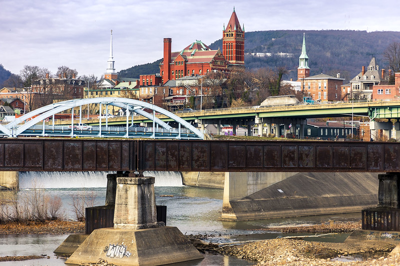
– photo by Mitch Waxman
Cumberland, Maryland. I’ve been here before, as detailed in these posts. I was kind of going for a post card look in the shot above. Didn’t have to use filters or anything to make the water look reflective and mirror like, as the entire region had been down in single digit temperatures the night before, and there was lots and lots of ice on the water.
This is the mouth of the C&O towpath canal, which is discussed in one of the prior posts in the link above.

– photo by Mitch Waxman
The emergent problem encountered, for a humble narrator, is that when you drive to place a hundred miles away you’ve also got to drive back home. The four hours of travel time seriously truncates photographic possibility, shortens the tenure of how long you’re willing to spend exploring, and causes you to question why you committed the time and gasoline to the endeavor.
This visit is part of my continuing attempts to visit and familiarize myself with the satellites of the Pittsburgh centered Megalopolis. Oil City and Titusville to the north, Wheeling in West Virginia, Cumberland in Maryland – all have been witnessed.
I’ve got a portfolio of future destinations – Morgantown in West Virginia, Cleveland in Ohio, Erie in Pennsylvania, all over this joint.
Cleveland and Erie, in particular, will require overnight stays due to distance and the length of the drive there. Definitely don’t want to execute a roughly 5 hour drive, and then have to just turn around and head back to HQ.
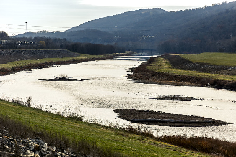
– photo by Mitch Waxman
That’s the North Branch of the Potomac River pictured above, with the left side of the shot in Maryland, while the right side is West Virginia.
Also, I should mention that as I’m old, I absolutely loathe driving at night – when adolescents prowl the interstates in Pickups, with no regard for law or custom. Additionally, you’ve got the ‘deer situation’ and ‘no street light dealie’ to handle out here. Brr.
As far as the aforementioned ‘deer situation,’ it is amazing how many ruminant corpses you’ll notice while driving along hereabouts, laying in shattered form alongside the roads.
Back tomorrow with more adventure for a strange man, in this strange land.
“follow” me on Twitter- @newtownpentacle
Buy a book!
“In the Shadows at Newtown Creek,” an 88 page softcover 8.5×11 magazine format photo book by Mitch Waxman, is now on sale at blurb.com for $30.
Salisbury Viaduct
Wednesday

– photo by Mitch Waxman
A humble narrator crossed the Mason Dixon line again recently, and just shy of the famous borderline between America’s ‘North and South,’ a visit was paid to the Salisbury Viaduct in Pennsylvania’s Somerset County, nearby the Commonwealth’s border with Maryland.
Part of the Great Allegheny Passage trail in modernity, this structure was built by the Western Maryland Railroad and opened to rail traffic in 1912. Abandoned in 1975 by the rail people, it was rehabbed into a bike and pedestrian ‘rail to trail’ which opened for inspection in 1998.

– photo by Mitch Waxman
I had a photographer buddy along with me on this particular day. We had delayed our original plans for this road trip to Maryland by a day, because of a precipitous drop in atmospheric temperature and a concurrent series of storms that manifested as the cold front moved in.
When we piled into the Mobile Oppression Platform (The MOP, aka my, my, my Toyota) back in Pittsburgh the next morning, it was 11 degrees outside.
It had warmed up a bit by the time we arrived at Salisbury Viaduct, about 22 degrees according the MOP’s dashboard display. I was wearing two fleece sweatshirts up top, but had neglected to put on thermal underwear leggings for the roadway interface section of the physical plant.
Told you that I’m an idiot in the mornings, and I should have laid them out the night before as a prophylaxis against my stupidity but there we are. My legs were quite chilly, thereby, but once we started walking…

– photo by Mitch Waxman
It’s pretty rural in this zone, which – I’m told – is the Casselman River Valley. Dairy farms, agricultural fields, highways. That’s the service road of US 219 pictured above, with the main road riding on top of those ramps at top left. It’s right here, if you’re curious or want to take a look around on Google Maps or something. Before you say it, I’ve been to the middle of nowhere – which is in Northern Arizona – and this ain’t it.
We were on our way to other locales, but one such as myself is always drawn to these sorts of places. It’s a liminal space! It’s also 101 feet off the ground, so ‘view.’

– photo by Mitch Waxman
Luckily, a CSX freight train was heading… north?… while I was still within throwing distance of the tracks. Recently, another friend (who is coincidentally the Brother of the guy I was hanging out with on this day), told me that I’ve become a railfan.
My answer to that one was that I no longer have tugboats. What do you all say? Have I transcended to a higher level of nerdom? Too much with the train stuff?
To be honest, I enjoy the challenge of shooting something that’s the size of multiple blocks of houses and moving along at 35mph through less than ideal lighting conditions. T’aint all that easy.

– photo by Mitch Waxman
We proceeded to walk the 1,908 foot span of the Salisbury Viaduct. My friend got busy with his camera in an old grave yard on the other side, whereas I became transfixed by a small dairy farm and what Our Lady of the Pentacle might call ‘Moo Cows.’
We had other places to get to on this day trip and a quick half mile walk back to the MOP, in the crisp winter air, was enacted.

– photo by Mitch Waxman
This spot is 115 miles from Pittsburgh, and 218 miles from Washington D.C. It kisses up against the Western Panhandle of Maryland, at its border with West Virginia. It was also very, very chilly.
Tomorrow, the Mason Dixon is crossed, and Western Maryland visited.
“follow” me on Twitter- @newtownpentacle
Buy a book!
“In the Shadows at Newtown Creek,” an 88 page softcover 8.5×11 magazine format photo book by Mitch Waxman, is now on sale at blurb.com for $30.


