unmistakable replacement
Truth tellers of the Subway!

– photo by Mitch Waxman
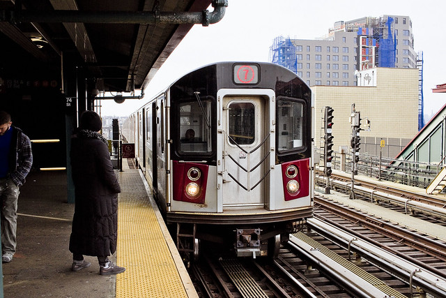
Occasion found me riding on the redoubtable IRT Flushing line recently, whereupon an older fellow noticed my camera and commented that I was an intelligence agent. I held my fingers up to my lips and made a shush sound, saying that the Russians were watching and asked him not to blow my cover. Once the train got under way, he took up position mid car and began a staggeringly well rehearsed speech about the Peoples Republic of China’s domestic security operations. What made this fellow stand out in my mind was – and I should mention that I’ve read a bit about how they handle dissent over there in the Middle Kingdom – was that he got a lot of it right. Names of the various agencies, location of reeducation centers and prisons… it’s scary when the paranoids are actually right about something.
He then began to opine that babies are traps set by female intelligence agents designed to snare unsuspecting males into child support servitude… but his info on the Chinese internal security system actually sounded fairly solid – and jibed with my admittedly limited knowledge of the subject. Maybe I’m destined to become one of those guys in my old age, the ones who carry a bunch of shopping bags and proclaim the truth of our times loudly to strangers on the 7 train.
– photo by Mitch Waxman
Given the headlines in recent years, it’s hard not to believe any claim – no matter how wild it is. We seem to have abandoned evidence and data based thinking as a culture these days. Not too long ago, I called up my buddy Kevin from Forgotten-NY to discuss a couple of things and during our chat I opined that if he told that “a flying jelly candy horse” was spotted over Bayside I’d have to believe it since anything seems possible at the moment. I suggest you hit YouTube at some point and search for “Flat Earth” if you want to see what I mean, as far as the abandonment of evidence and data based decision making.
Back in high school and college, as my friends and I would engage in long conversations trying to figure the world out, we’d always apply Occam’s Razor (the simplest explanation is usually true) to any crazy story we came across. My answer to 911 conspiracy theorists has always been to remind them of every other thing which the George W. Bush White House tried to pull off, and ask if there was any indication that the same people who brought you the Federal response to Hurricane Katrina and the 2003 invasion of Iraq had it in them to pull off an absolutely perfect “false flag” operation. I then remind them of the complexities involved in arranging for six people to meet up for lunch at a diner on a Saturday afternoon (there’s always a Vegan to account for, and someone named Sharon who’s always late).

– photo by Mitch Waxman
I don’t encounter the same sort of crazy on the IND lines, downstairs as it were, in the subways. The E/R/M lines are plagued by women doing the “Gypsy baby” routine, those acrobatic dancer kids, and the freaking mariachis. They’re all just grifting or busking though, and trying to earn a living. The Chinese conspiracy guy on the 7 line was highly entertaining, to me at least, and made my $2.75 fare a gladly spent trifle.
Here are three of my paranoid wonderings;
The woman who calls herself Britney Spears currently performing in Las Vegas is a lookalike double. The real Britney Spears is being held prisoner by her managers in a Nevada mental asylum. #freebritney.
The plastic or metal tips on your shoelaces are called aglets. Their purpose is sinister. #thetruthwillcomeout
Given the relative scale of the Gummi Bear to the Gummi Worm, it’s obvious that the Gummi universe is actually based on the Dune universe, with the Bears being the Freemen and the Gummi Worm representing the sandworm Shai Halud. #thesleeperwillawaken
Repent!
“follow” me on Twitter- @newtownpentacle
Buy a book!
“In the Shadows at Newtown Creek,” an 88 page softcover 8.5×11 magazine format photo book by Mitch Waxman, is now on sale at blurb.com for $30.
concise malfeasances
Finishing up the Soundview ferry trip.

– photo by Mitch Waxman
The NYC Ferry Soundview line trip I’ve been describing all week, which started at Pier 11/Wall Street and then proceeded northwards along the East River to stops at first 34th, and then 90th street, before heading into the narrows at Hells Gate and Bowery Bay. The route actually gets you fairly close to two of the most difficult to reach islands in NY Harbor, the Brothers (North and South). Setting foot on either island is forbidden, as they’re both bird sanctuaries. Saying that, I’ve been on South Brother in the past, having gone there with the NY Audubon Society. North Brother is pictured above, and it’s somewhere I’ve always wanted to get to, despite the legendary number of ticks and other hazards which its meant to provide a home to.
North Brother is about 20 acres in size, and is owned and operated by the NYC Parks Dept.

– photo by Mitch Waxman
That building is the mortal remain of Riverside Hospital, which relocated itself from Welfare Roosevelt Island in 1885. Riverside specialized in quarantine illnesses like smallpox and tuberculosis, and it’s where Typhoid Mary was imprisoned for over twenty years. Mary, whose real name was Mary Mallon, died on North Brother in 1938. In 1904, North Brother was where the General Slocum disaster came to an end, with the boat beaching onto its shores and where the bodies of over 1,000 of the disasters victims washed up. Riverside continued on through the middle to late 20th century, during the 1950’s and early 60’s, it was an adolescent addiction hospital. Corrupt management and changing circumstances saw the City shutter the facility in the early 1960’s, and the buildings were abandoned to the elements.
Until 1964, North Brother was formally part of first Long Island City (after 1870) and then Queens County (after 1898), but after the Parks Dept. took formal control of the island in 2001 and both islands became part of Bronx county in 2007.

– photo by Mitch Waxman
There are some pretty staggering views of the whole “soup bowl” as I call it, from the NYC Ferry’s Soundview line. Definitely worth your $2.75 fare, I would argue. Here’s a tip – download the NYC Ferry app to your phone and buy the ticket that way. The ticket stays active for 90 minutes, meaning that if – like me – you’re not planning on debarking the boat and just plan on riding it back and forth for lookie loo, you can do so on one fare.
Back on Monday with something completely different at this, your Newtown Pentacle.
“follow” me on Twitter- @newtownpentacle
Buy a book!

“In the Shadows at Newtown Creek,” an 88 page softcover 8.5×11 magazine format photo book by Mitch Waxman, is now on sale at blurb.com for $30.
In the Shadows at Newtown Creek
The big announcement is here, and it’s a photo book!

– photo by Mitch Waxman
In the Shadows at Newtown Creek is finally ready for public consumption, I’m proud to announce. 88 pages of full color photos encased in a perfect bound card stock cover edition, this is the first of several publications which Newtown Pentacle will be offering this year. This edition is a magazine format photo book, one embellished with minimal text beyond simple descriptions of location. It collects the night photography work which I’ve been engaged in for the last year around the Newtown Creek Superfund site at locations in Long Island City, Greenpoint, Maspeth, Ridgewood and East Williamsburg/Bushwick.
The sales price is $30, and here’s the link again.

– photo by Mitch Waxman
I’ve chosen blurb.com as the printer, who will handle ordering and fulfillment. Sample copies in hand look and feel great, and everybody whom I’ve shown them to has been blown away by the quality of their printing. I’m thrilled with it, and hope that everybody reading this will consider placing an order for a copy of the book. A not insignificant percentage of the sales price will end up in my pocket, which will help support this blog and the time and expense that go into producing it.

– photo by Mitch Waxman
Many of the photos contained within “In the Shadows at Newtown Creek“ have been displayed at Newtown Pentacle soon after they were captured, such as the shot of the Greenpoint Avenue Bridge pictured above and of Maspeth Creek pictured below. The urban landscape around this highly industrialized waterway found at the heart of New York City is frankly spectacular, visually dynamic, and I have been working extremely hard to capture its vibrant spirit.

– photo by Mitch Waxman
For those of you new to the Newtown Pentacle and the world of Newtown Creek, I’m Mitch Waxman.
I’m the Newtown Creek Alliance historian, official photographer for the Working Harbor Committee, Steering Committee at Access Queens, and also a member of the NYS DOT’s Stakeholders Advisory Committee for the ongoing Kosciuszcko Bridge project. I’ve been offering walking, bus, and boat tours of the Newtown Creek watershed, and the greater harbor beyond, for nearly a decade. I’m a steering committee member of the Newtown Creek Superfund Community Advisory Group, serve as an ad hoc member of the Newtown Creek Monitoring Committee (which provides citizen oversight of the DEP’s sewer plant project in Greenpoint), and I was a Parade Marshall for three of the NYC Bridge Centennial Committee celebrations back in 2009 including the Manhattan and Queensboro events. My photography of Newtown Creek and NY Harbor has appeared in National Geographic, the NY Times, Scholastic publications, lots of local websites and newspapers, several official NYC and NYC EDC publications, as well as a bi weekly column I used to write for Brownstoner about Westrn Queens. On June 9th of 2009, this blog – the Newtown Pentacle – was founded, on the day of the Queensboro Bridge centennial.
– photo by Mitch Waxman
For the last several years, the shots that I’ve captured which have really caught my eye have been the long exposure night time ones, and in the last year or so it was decided to “get serious” about low light urban landscape shooting. The results gathered from Newtown Creek are collected in this new book of mine. Blurb.com’s “In the Shadows at Newtown Creek” sales page offers an online (partial) preview which will give you an idea of the layout, and content, of this publication.

– photo by Mitch Waxman
Geography governed the placement and sequence of the images presented, starting with Newtown Creek’s intersection with the East River and then ranging nearly 4 miles eastwards towards the bitter end of things at the English Kills tributary in Bushwick/East Williamsburg. Along the way, every bridge, important site, and tributary is visited – many of which are locations accessible only through jagged holes in chain link fences or through acts of physical derring do.

– photo by Mitch Waxman
A chance to support for this blog, and a humble narrator, is offered. June 9th of this year will mark the tenth anniversary of this publication, which publishes five days a week and fifty two weeks a year. I’m beginning to think about doing some sort of event to celebrate the anniversary, as a note. Also, there will be more print publications later in the year.
“In the Shadows at Newtown Creek,” an 88 page softcover 8.5×11 magazine format photo book, is now on sale at blurb.com for $30. I hope you’ll consider adding it to your library.
“follow” me on Twitter- @newtownpentacle
alienists were
Dag, I really got my $2.75 worth out of this ferry ride, huh?

– photo by Mitch Waxman
Continuing my maiden voyage on the NYC Ferry’s new Soundview route, the boat left its (Manhattan) East 90th street dock and proceeded towards Hells Gate. This is a spot I often visit, but always from the landward side in Queens. Living in Astoria, a frequent destination when I’m out for a constitutional walk is Shore Road, which adjoins Astoria Park and provides commanding views of two bridges which I’m rather enamored with – the Triborough and Hell Gate. The former is just one part of a complex of automotive bridges built under the guidance of Robert Moses which opened in 1936. The latter is a rail bridge (OK, technically it’s a complex of bridges too) which opened in 1917, designed by Hornbostel and Lindenthal, and constructed by Carnegie’s American Bridge Company for the Pennsylvania Railroad Company.
Hells Gate is formerly the most treacherous section of the East River, due to whirlpools and strong currents which wrecked hundreds of ships during colonial and early republic times. Its name is an anglicization of the old Dutch “Hellegaat” which refers to “a bright passage.” The hazardous conditions in this section of the East River were caused by the topography of the riverbed beneath the water, a situation which was dealt with by the United States Army Corps of Engineers in several stages during the 19th century. The USACE efforts culminated with an 1885 detonation of mined explosives that broke up the riverbed, an explosion which was the largest intentional detonation in all of human history until the Hiroshima atomic bombing in 1945 (debate about certain WW1 military actions does exist on this topic, btw.)

– photo by Mitch Waxman
As the Ferry moved northward towards its destination at the northern side of the Bowery Bay section of the river, we passed by the “Astoria Energy” power plant located on the forbidden northern shore of Queens. That nomen is one of my own little inventions, indicating the frustration a humble narrator often expresses when discussing the coastlines of the Borough. There’s a solid wall of “not allowed” secure sites along the shoreline, which is ultimately prosaic and appropriate, but still frustrating. You’ve got the power plant, then a sewer plant, then Rikers Island, and then LaGuardia Airport. The first time you might be able to get close enough to even see the water is at Flushing Bay.
Fingers crossed for an East Elmhurst or Flushing Ferry line, anyone?

– photo by Mitch Waxman
I’ve seen this POV a few times over the years, but it’s still pretty uncommon for me. That’s Randalls/Wards Island on the right, which used to be seperate islands until Mr. Moses made them one landmass as part of the Triborough project. Hells Gate and Triborough’s East River span are at center, and the former Politti Power Plant (which the Astoria Energy outfit now uses as its campus) are on the left.
More tomorrow, at your Newtown Pentacle.
“follow” me on Twitter- @newtownpentacle
possible cure
On the boat.

– photo by Mitch Waxman
As mentioned yesterday, I took a ride on the new Soundview line of the NYC Ferry recently in pursuance of scouting out a tour which I’m going to conduct along its route. Soundview is a long ride by the standards of the new Ferry system, some 46 minutes. It takes you north from Pier 11 Wall Street along the eastern shoreline of Manhattan with stops at 34th street and then at 90th street. Its path carries you along the rather familiar sights of the great bridges section of the East River (Brooklyn to Queensborough) and then proceeds into the River’s west channel between Roosevelt Island and Manhattan.
Pictured above is a tug towing an empty fuel barge southwards along the waterway. How do I know it’s empty? Look at how high the barge is riding in the water… that’s how.

– photo by Mitch Waxman
The west channel of the East River is preferred for the passage of larger ships and maritime industrial traffic for a couple of reasons, most notably the absence of height restrictions due to the Roosevelt Island Bridge and the “no wake” zone around the Big Allis power plant in Queens’ Ravenswood section. The Soundview ferry uses this channel to proceed northwards, passing by notable Upper East Side landmarks like Rockefeller University in the East 60’s.
That’s another huge articulated tug and fuel barge in the shot above, operated by the Reinauer company. Articulated means that there are cabling connections which allow the Captain of the tug to operate the two entities as a single vessel. There is also a large cutout notch in the bow of the barge which the tug nestles into.

– photo by Mitch Waxman
Last stop in Manhattan is at East 90th street, whereupon the ferry route heads across the East River to the east channel, and heads into Hells Gate. Those of you with a historical mindset might already have an inkling of what this tour will be talking about, but let’s just say that a little bit more than a century ago on a nice morning in mid June, a large group of people boarded a boat just north of Wall Street at Peck Slip, and more or less followed this route. Things did not go as planned for them, and bad things happened. Very, very bad things.
More tomorrow, at your Newtown Pentacle.
“follow” me on Twitter- @newtownpentacle


