Posts Tagged ‘kosciuszko bridge’
habitual secretiveness

– photo by Mitch Waxman
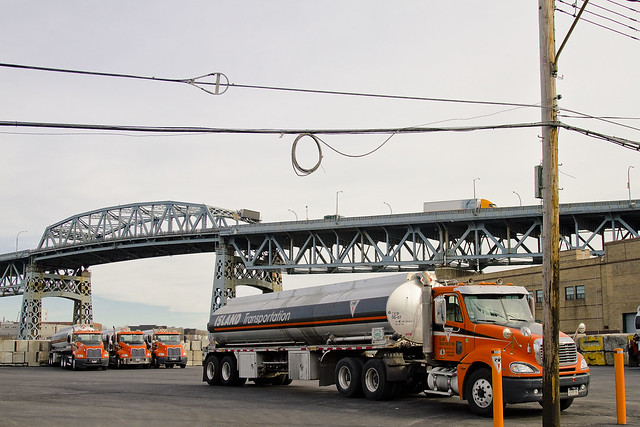
DUKBO, on the Brooklyn side of that parable laden river of urban neglect called the Newtown Creek, is an industrial zone which most New Yorkers wouldn’t want to acknowledge ownership of. The particular stretch which is focused on today is not long for this world, as the replacement of the Kosciuszko Bridge will obliterate these streets from the map when construction begins in 2014.

– photo by Mitch Waxman
Owing to the impermanence of this area, and the certain doom it will enjoy, your humble narrator has been making it a point to divert my path into its shadowed corridors and record what might exist here. As mentioned to many, one of the goals of this- your Newtown Pentacle- is to leave behind some sort of record of what the Creeklands were before the massive changes wrought by Superfund, the Kosciuszko Bridge replacement, and all the other mega projects planned for the area begin.
It is, in my opinion, important to have the realities of this place reported on by a source not affiliated with commercial or governmental interests, and to allow some future researcher to witness the inheritances of the past as they were at the start of this century. The paucity of documentation about Newtown Creek at the start of the 20th century are a major impediment to studying its history.
That’s my “elevator speech”, by the way.

– photo by Mitch Waxman
Of course, the specific focus of today’s posting has little to do with history, rather it’s the utter immolation suffered by this vehicle (refer to a Newtown Pentacle post of January 4, 2012 titled “Old School 2” for context). It seems that DUKBO continues to be a great place to ditch an unwanted vehicle, and the complete destruction of this automobile speaks to a considerable interval between ignition and the intervention of the NYFD.

– photo by Mitch Waxman
That’s an assumption, by the way, based on the absolute destruction of the vehicle interior. The absence of doors, engine hood, and other usual amenities found on modern cars (not present lying in some heap on the sidewalk) suggests that the vehicle was probably stripped, abandoned, and torched- but that is another assumption. Both of these are wide interpretations born of having grown up in South Brooklyn during the 1980’s, a time when an epidemic of car thefts and vehicular arson ran rampant and vehicles in similar condition would regularly be encountered along the Belt Parkway and its service roads.
Kids in my neighborhood became very familiar with the difference between “an accident” and an “on purpose”.

– photo by Mitch Waxman
Can’t blame NYFD for not getting to it in time for anything else than extinguishing the husk, as this is the middle of nowhere and residential housing is quite distant in any direction. At night, this a ghost town, with shuttered businesses and truck lots, and little or no traffic. Who can guess what transpires here, in the dead of night amidst the darkness of DUKBO?

– photo by Mitch Waxman
If you’re missing what looks like a mid size SUV or perhaps a minivan, this corner in DUKBO seems to be a great place to start looking for what remains of it.
verdant valley

– photo by Mitch Waxman
While preparing the slideshow which was recently presented at the Ridgewood Democratic Club, which is one of two updated versions of the thing (differing lengths), I’ve been churning the content waters deeply. One of the little collections of images which I pulled together was called “Kosciuszko Bridge”.

– photo by Mitch Waxman
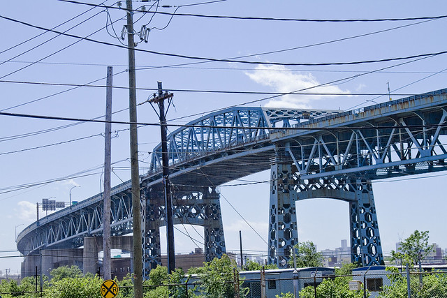
For awhile now, special attention has been paid to this decaying structure, due to those plans held by State employees and agencies to replace it with a modern bridge designed to overcome many of the flaws exhibited by the 1939 era “Meeker Avenue Bridge” – which was later renamed as the Kosciuszko Bridge in 1940.

– photo by Mitch Waxman
It’s a lumbering and brutish design, inelegant, undistinguished, and strictly utilitarian. Which sort of makes sense given its construction during the latter half of the Great Depression.

– photo by Mitch Waxman
Literally, and figuratively, this is Down Under the Kosciuszko Bridge Onramp, DUKBO. This is on the Brooklyn side, incidentally.

– photo by Mitch Waxman
This post isn’t intended to carry any deep insight or reveal some historical truth. To confess, I’m showboating a bit today, and featuring something that won’t be here too much longer.

– photo by Mitch Waxman
One thing you will notice in these shots is the horrific amount of corrosion which the bridge displays. This is, of course, why the State plans on replacing it in a few years time.

– photo by Mitch Waxman
Naked, the bridge shows the lines of force which it’s engineered around, and for a structure that carries something like 200,000 vehicle crossings a day- that’s a lot of force. The Kosciuszko Bridge trusses are just so damned ugly about it, unlike the graceful curvilinear shaping of the Hellgate or Bayonne arches.

– photo by Mitch Waxman
The reason it’s so high, around 150 feet of clearance at low water, is that ocean going ships used to come all the way back here. Not sail, although that was a consideration in 1939, but the smokestacks of ocean liners were what it was flung into the sky to accommodate.

– photo by Mitch Waxman
Sliding over to the Queens bank, where the piles are driven into compacted mud and sand instead of bedrock, the legs of the bridge straddle the former home of Phelps Dodge. The neighborhood around these parts formed the border between the villages of Berlin and Blissville.

– photo by Mitch Waxman
From what I’ve been told, the former Phelps Dodge site is in private hands, but parts of it will house the new bridge which will replace the 1939 model. From the planning statements I’ve read, the new Kosciuszko Bridge won’t be quite so high.

– photo by Mitch Waxman
It seems that the needs of the trucking industry will be acknowledged in the design of the onramps, which will not present quite as steep a grade to the angle of their approaches. I’ll miss the scale of the current bridge, I fear.

– photo by Mitch Waxman
Like the nearby Megalith at Court Square in Long Island City, the Kosciuszko Bridge provides a geographical frame of reference for miles around. The only other bridges of sufficient scale to provide such service span the East River or provide connection to… Staten Island…

– photo by Mitch Waxman
The Kosciuszko Bridge, on the Queens side, follows the shallow valley between Laurel and Berlin Hills, both of which are graded down shadows of their former selves. There must have been dense woods here once, bisected by a shallow stream that fed into the Newtown Creek.

– photo by Mitch Waxman
The Maespetche Indians who lived here were mostly wiped out by Smallpox by the 1700’s, and by that time the Dutch had already established a few homesteads here. When the English arrived, often overland from Eastern Long Island, they mocked the degenerate Dutch with their old fashioned customs and bizarre beliefs.

– photo by Mitch Waxman
The English had plenty of controversies in this area themselves, with the bizarre adherents of the “Friends” cult showing up time and again from New England via the Long Island Sound, the presence of accused witches, and all sorts of odd religious experimentation by commoner and courtier alike going on.

– photo by Mitch Waxman
All that sort of nonsense ended in the early 1800’s, when the post revolutionary industrial boom got started here in DUKBO. General Chemical came in the 1840’s, and joined with the distilleries and fat renderers who had been here for years to participate in what we would call “the industrial revolution”.
Things really kicked into gear when the Long Island Railroad laid down track in the 1860’s and 70’s.

– photo by Mitch Waxman
Of course, in 1848, Dagger John Hughes buried Esther Ennis and consecrated Calvary Cemetery as the official burying ground of the Roman Catholic Church. Construction of the cemetery on Laurel Hill was largely finished by the late 1850’s, which removed approximately 360 million tons of topsoil from the hill and installed an enormous drainage system within it to dry the swampy land.

– photo by Mitch Waxman
In the 1890’s, there were still homes and saloons, schools and churches here. Calvary grew by land acquisition and donation, and industrial pursuits rendered the whole area around these parts a smoky, soot stained mess.
And then, there was the smell.

– photo by Mitch Waxman
The smell is legendary in the historical record, it seems that it’s all that the riders of the Long Island Railroad could talk about. Health Department records preserve complaints presented by residents of Manhattan who opined that the stink actually extended all the way to Turtle Bay (approximately 34th street).

– photo by Mitch Waxman
All that is gone now, although on humid days after heavy rains, the stink is still more than just a memory.
As are the chemicals in the ground and water which all that industrial growth left behind for the future.

– photo by Mitch Waxman
Definitely. I’m going to miss the big K when it’s gone, wonder what interesting things will be found in DUKBO when the shovels hit the dirt.
After all- who can guess, all there is, that might be buried down there?
demoniac alteration

– photo by Mitch Waxman
Fiery concatenation and syncopated horror haunt my steps whenever visting DUKBO.
Sarcastic and conceit laden, the label I give to this place is nevertheless apropos, for it is very much Down Under the Kosciuszko Bridge Onramp.
Welcome to DUKBO on the Brooklyn side of Newtown Creek- beneath the thrice damned Kosciuszko Bridge. It’s the sort of place which might best be described as either an “M1 industrial zone” or as a “literal hell on earth”.
Either way, it has been like this around here since around the Civil War.
from Harper’s weekly, Volume 38, 1894- courtesy Google books
AN INSALUBRIOUS VALLEY.
The city of Brooklyn, having purged itself of the malodorous political institutions that were so long a blot upon its southern border, might well turn its attention to some nuisances of a more literally malodorous kind that flourish along its northern border, a detailed description of which will be found in another column of the Weekly’. It appears that in an early day the valley of Newtown Creek, which is the boundary between Kings and Queens counties, was selected by various manufacturers as an eligible site for the location of factories. The location was then far on the outskirts of the city, and no doubt quite unobjectionable. A great variety of institutions were set iu operation here, including those useful and necessary but unpleasant factories whose purpose it is to transform the animal refuse of a city into merchantable produce. The gases generated by these factories had an odor almost unendurable, as any one can testify who was accustomed to travel on the Long Island Railroad from the Thirty-fourth Street ferry in years gone by.

– photo by Mitch Waxman
Elucidating on J. Rosenberg’s “model tallow rendering factory”, or the infamous Night Soil Dock of Conrad Wissell, or the extant nightmares of the Kings County Chemical works would be superfluous if describing the 19th century industries located on either side of the Newtown Creek as “dirty”.
They were good guys, who at least attempted to reform their industrial practices. It was the smaller operators in the distillery and fat rendering trades who were truly vile, at least according to the historical record.
Describing the transport and storage of rotting butchers scrap, animal waste, rotten eggs, and dead horses- all of which sat stinking in the summer sun while waiting to be weighed by the rendering plant bosses- or envisioning the attendant plagues of insect and rodentine vermin which followed these redolent piles (whose numbers were checked only by the acid rain and those environmental calamities which were caused by unregulated petroleum and chemical interests) from points all over the cities of Brooklyn, Long Island City, and New York would surely be a form of macabre and historical pornography.
However, that’s what the businesses here used as raw materials.
from The Sanitary Era, Volume 1, 1887, courtesy google books
Newtown Creek — No city in the Union has so foul a pest hole at its boundaries as Brooklyn. The sludge acid discharged from the works of the Standard Oil Company seems to possess an ominous potency for stirring up the sewage in the creek, and its black and thickened current seethes with bubbles of sulphuretted hydrogen. The shores, banked with this acid and with nameless filth, empoison the atmosphere at low water, while every rising tide seems to free a new supply of sludge. When to the oil industry is added the manufacture of fertilizers and a plenitude of pigs along Queens County shore, the sources of supply for a great nuisance or a grievous plague are discernible to all but official eyes and nostrils. Newtown Creek should be filled up, though not with sludge acid, and the nuisance makers removed to a distance. Our, Health Commissioner is authority for the statement that “You might as well try to fight the devil as the Standard Oil Company.”

– photo by Mitch Waxman
There have always been jobs here, the sort of jobs which those who cannot find employment in conventional occupations covet. Topical observation of the area reveals the modern presence of scrap yards, abattoirs, warehouse and trucking concerns, and light manufacturing facilities. Of course, the gargantuan National Grid property is nearby, but that’s a horse of a different shade.
There are a LOT of scrap yards in this little slice, this angle between the neighborhoods of Greenpoint and East Williamsburg, which creates a concentrating point for heavy metals. Of course, this is still preferable to the lagoons of sludge acid and animal waste which distinguished the place 100 years ago.
from The City record, Volume 6, Part 4, 1878, courtesy google books
Newtown Creek for many years has been a source of nuisance. It receives the contents of several of the large sewers ot Brooklyn. From above Penny Bridge to the East river are factories of various descriptions, oil refiners, fat inciters, gut cleaners, distilleries, car stables, super-phosphate factories, ammonia works, varnish works, and last, but not least, immense piles of stable manure, stored for future shipment, the refuse from all of which runs into the creek, and polluting the waters to such an extent as to have killed all the fish.
At low tide acres of land, covered to the depth of several inches with fat, the refuse of the oil-stills, are exposed. At high tide the oily portion of this refuse floats on the surface of the water, still giving forth its characteristic tarry odor. To add to this, many oil works, when the storage tanks are full, run their waste alkali and even their sludge-acid into the creek; in the latter case giving rise to the well known sludge smell.

– photo by Mitch Waxman
Faceless, those who labor here find themselves stained with “the colour”, an iridescent sheen permeating the Creeklands that no known detergent can easily remove. These laborers are exposed to precipitate from the endless truck and automotive traffic passing by on the highway and bridge above, a dusty particulate rises from tire shattered roadways, and the very air they breathe is a poisonous fume of industrial chemicals and spent fuel. Live poultry concerns, some quite large, maintain depots here as well. The birds, like the workers, quickly display the colour.
This colour is like no earthly hue, rather it is like something from out of space, and a stark contrast to the Shining City of the western horizon just a few miles away.
from nytimes.com
THE NUISANCES MUST GO; Gov. Flower Says that Newtown Creek Must Be Purified. FIVE FACTORIES ORDERED CLOSED Private Business Not to be Allowed to Jeopardize the Health of Brooklyn and Long Island City
crystal oblivion
– photo by Mitch Waxman
The other day I had the pleasure of some company on one of my little walks, Ms. Heather from NY-Shitty, and together we perambulated the hinterlands of Brooklyn- a no mans land between Greenpoint and East Williamsburg which has long been referred to as DUKBO in postings at this, your Newtown Pentacle.
This is a dusty, worn down, and fairly evocative place, crammed to the gills with industrial yards and century old mill buildings. A palpable evil lurks about the place, and the colour coats every surface. As a boy, when I asked my dad what was down there- he would turn pale, and demand promises that I never visit this area. This is the darkest of the hillside thickets found along the Newtown Creek, after all, legendary homeland of all that might go wrong under the American system of government.
Sorry Pop.
from the “Fellowship of the Ring” by Peter Jackson, et al.
Boromir: One does not simply walk into Mordor. Its black gates are guarded by more than just orcs. There is evil there that does not sleep, and the Great Eye is ever watchful. It is a barren wasteland, riddled with fire and ash and dust, the very air you breathe is a poisonous fume. Not with ten thousand men could you do this. It is folly.

– photo by Mitch Waxman
There was a pretty good reason that I was in the neighborhood, which will be discussed in later postings, but we soon found ourselves traipsing along beneath the rotting steel of the Kosciuszko Bridge. This is a fairly dangerous place, from a pedestrian point of view. Trucks rattle by at full throttle, sidewalks (when they exist) exhibit broken concrete and pooled water. Hideously barbed weeds sprout from the shattered roadbeds, and from every abyss something or someone stares back suspiciously.
There is nowhere to run to, in this abattoir of hope- your best hope is to attempt to fit in.
This clip from the same director’s “Return of the King” neatly encapsulates the sort of day Ms. Heather and I experienced:
w

– photo by Mitch Waxman
Mad stories have been told to me by those who labor in the area about what transpires in the fuligin hours around these parts, tales which I am duty bound not to repeat. Suffice to say that certain “ethnic fraternities” and other “ad hoc associations” maintain a certain presence in this locale, the members of which desire privacy and the cover of night to pursue their crafts. Said privacy is zealously guarded, as much of the City has been denied them by the efforts of an alliance of regional and national law enforcement.
Even during the daylight hours, the sure knowledge of their presence informs and constrains my movements and actions, but I’m from Brooklyn and know that what lurks around these parts both demand and deserves “Respect”.
As I’ve been told in the past by members of these groups- “Don’t ‘eff around back here”. Additionally, scholastic and mainstream critics have accused me of describing this area as “Mordor”, and that its not that bad.
from wikipedia
Three sides of Mordor were bounded by mountain ranges, arranged in a rough rectangle: Ered Lithui, translated as ‘Ash Mountains’ in the north, Ephel Dúath, translated as ‘Fence of Shadow’ in the west, and an unnamed (or was possibly still called Ephel Dúath) range in the south. In the northwest corner of Mordor, the deep valley of Udûn formed the region’s gate and guard house. That was the only entrance for large armies, and was where Sauron built the Black Gate of Mordor, and later where Gondor built the Towers of the Teeth. Behind the Black Gate, these towers watched over Mordor during the time of peace between the Last Alliance and Sauron’s return. In front of the Morannon lay the Dagorlad or the Battle Plain.
Within this mountainous region, Sauron’s main fortress Barad-dûr formed its tower, at the foothills of Ered Lithui. To southwest of Barad-dûr lay the arid plateau of Gorgoroth, forming the region’s keep, and Mount Doom its forge. To the east lay the plain of Lithlad.

photo courtesy wikipedia-
Mount Doom and Sauron’s tower of Barad-dûr in Mordor, as depicted in the Peter Jackson film

– photo by Mitch Waxman
Of course, that’s a ridiculous charge.
When have I ever suggested that there is some disembodied evil, a great eye, lurking at the top of a tower that looks down over some ash blasted wasteland which has a river of poison flowing through it?
Happy Birthday, Kosciuszko Bridge

– photo by Mitch Waxman
A virtual guarantee is offered that this is the only posting you will see today commemorating and wishing the Kosciuszko Bridge a happy 72nd birthday. Some 26,298 days ago, Robert Moses saw the first link in a crazy idea of his which would one day be called the “Brooklyn Queens Connecting Highway” open for business.

– photo by Mitch Waxman
The Meeker Avenue Bridge opened on August 23rd, 1939 (renamed in 1940 as The Kosciuszko Bridge) – some 631, 152 hours ago. It was promised to allow easy egress to the World’s Fair, and was a showpiece project for the Great Builder.

– photo by Mitch Waxman
From a Newtown Pentacle posting of December 8, 2010– in which the big K was described as thrice damned:
Damned Once- The Kosciuszko Bridge catches radio frequency emissions from several nearby commercial radio broadcast antennas. A lot of it.
Whatever knows fear burns at The Kosciuszko Bridge’s touch.
Damned Twice- The Kosciuszko Bridge is at extreme risk in the eventuality of a seismic event. The Brooklyn pier actually sits on the Creek bed, some 6 meters below grade, but the Queens side is anchored on piles driven into the mud. The hard soil around Queens Plaza will merely shake, but the land surrounding the Newtown Creek will liquify.
Damned Thrice- The Kosciuszko Bridge once had pedestrian walkways, but they were removed in 1961. Can you imagine what kind of photos would be possible on a pedestrian walkway 124 feet over the Newtown Creek?
– photo by Mitch Waxman
Like many things and people who are 72 years old, the Kosciuszko Bridge is not long for this world. Why not raise a glass to it tonight, and acknowledge its long service to the City?
Click here for a sentimental slideshow of the old girl from the last couple of years


