Posts Tagged ‘Manhattan’
Hudson River
Another of those crazy days, I was invited to ride along on the yacht Manhattan recently, as it made its journey home to Scarano Boatbuilders in Albany for a checkup and scheduled maintenance. The day was unfortunately misty, but the slideshow will show you what I saw. There’s a couple of sequences in here which will get the full treatment- Esopus Island for instance- but that’s way off in the future. Right now, check out a trip from Manhattan to Albany via the Hudson River.
exhausted
Phew. Busy couple of days… sorry for the lack of contact. Creek week is extending into next week as well, but check out what I did on Friday the 5th.
– photo by Mitch Waxman
On Friday, I attended a ceremony which placed a time capsule in the Manhattan Bridge, then walked from Chinatown to Astoria, developed a LOT of photos, slept 4 hours.
Saturday- woke up, took a ride on the Staten Island Ferry, then walked part of the Kill Van Kull shoreline , visited my sick mom in the hospital, and came back to Astoria.
Tomorrow is the “St. Pat’s Day for All” parade in Sunnyside- which promises to be enjoyable AND photogenic- if you’re around the neighborhood- don’t miss it.
Now, here’s a few shots from the Manhattan Bridge event.

DOT Commissioner Janette Sadik-Khan – photo by Mitch Waxman
from nyc.gov
Janette Sadik-Khan serves as the Commissioner of the New York City Department of Transportation since her appointment by Mayor Michael R. Bloomberg in April of 2007. She manages 4,500 skilled employees with wide ranging expertise from engineering to construction finance, to marine navigation, and is responsible for 6,000 miles of streets and highways, nearly 800 bridges, 1.3 million street signs, 300,000 streetlights and 12,000 signalized intersections, as well as the Staten Island Ferry, the nation’s busiest commuter ferry service carrying over 19 million passengers annually.
Since her appointment, Sadik-Khan has implemented an ambitious program to improve safety, mobility and sustainability throughout New York City, and ensure a state of good repair on all the Department’s roads and bridges. In April 2008 the Agency published its Strategic Plan, Sustainable Streets. Projects highlighted in that plan include the first Select Bus routes for NYC, the NYC Plaza Program, the creation of Broadway Boulevard in midtown Manhattan, the addition of 200 miles of on-street bike lanes, car-free summer streets and weekend pedestrian walks.

“Gridlock Sam” Schwartz – photo by Mitch Waxman
from gridlocksam.com
From 1982-86, Sam Schwartz served an extremely successful term as New York City’s Traffic Commissioner before going on to serve the next four years as the New York City Department of Transportation’s Chief Engineer/First Deputy Commissioner.
After nearly twenty years with the New York City Department of Transportation, Mr. Schwartz moved from public service in 1990 to join Hayden-Wegman Consulting Engineers, Inc. as Senior Vice President in charge of transportation engineering, infrastructure, quality control and planning.
In the summer of 1995, The Sam Schwartz Engineering opened its doors with a staff of two. Since that time, the company has grown to include over sixty diverse professionals. Today, under Sam’s direction, The Sam Schwartz Engineering produces some of the finest work in civil engineering, planning, and urban design.

Henry Perahia, Deputy Commissioner Chief Bridge Officer DOT – photo by Mitch Waxman
from nyc.gov
In 1998 Mr. Perahia was promoted to Chief Engineer of the Department. In 1999, he was given the added responsibilities of Chief Bridge Officer. As Chief Engineer, he serves as the Department’s representative on all engineering issues, including review of all major Department projects, response to engineering emergencies, and advising the Commissioner on all engineering issues. As Chief Bridge Officer, he is responsible for the planning and administration of all aspects of design, construction and maintenance of approximately 750 City-owned bridges, tunnels, and culverts, with an annual capital program of approximately $500 million and an annual expense budget of approximately $56 million.
The Division of Bridges is responsible for maintaining the structural integrity of all City owned bridges and tunnels. It undertakes the design and construction of all rehabilitation and reconstruction work, including in-house design, engineering support, engineering review, and quality assurance. It inspects the City’s bridges to identify hazardous or potentially hazardous.

A few of the items that were placed in the Time Capsule – photo by Mitch Waxman

The assembled crowd of dignitaries, DOT workers, and invited well wishers – photo by Mitch Waxman

The time capsule was sealed up within the ornate arches of the Bridge – photo by Mitch Waxman

Specifically, right about here (this is inside the arch) – photo by Mitch Waxman

How could I not have a look around? I mean, how often are you inside the Manhattan Bridge, after all? – photo by Mitch Waxman

A window? – photo by Mitch Waxman

Here’s the view from said window – photo by Mitch Waxman
for the complete set of photos at flickr- click here
Kneeling upright

– photo by Mitch Waxman
The local supermarket, a Pathmark on Northern Blvd., has installed a device on its shopping carts that lock the wheels when you try to roll them off the property line. A buried wire, perhaps, or some sort of radio signal keeps the carts from distributing themselves around the neighborhood like the Home Depot and Stop n’ Shop carts that can found in basements and garages across the Newtown Pentacle. Once, this was the preferred cargo carrier for New York’s unfortunates, an uncovered wagon for the concrete prairies.
from wikipedia
Shopping cart theft can be a costly problem with stores that use them. Often the carts end up in apartment complexes, low-income housing, bus stops or locations where the person doing the shopping is unlikely to own a car. The carts, which cost between $75 and $150 each, have been used for such purposes as barbecue pits, go-carts, laundry trolleys and even shelters, or they are simply abandoned. Because such losses can be substantial (up to $800 million globally lost every year), stores have resorted to various systems to prevent theft. Stores may use one or more of these systems (i.e., cart retrieval and electronic).
Cart retrieval service
Some stores utilize a cart retrieval service, which collects carts found off the store’s premises and returns them to the store for a fee. The drawbacks of this measure include that it is reactive instead of proactive (i.e., it can only be used once a cart has been taken from the premises), can become costly, and does nothing to deter hoarders. Some retrieval services have also been caught taking carts from the store’s parking lot and turning them in as stray carts.
Electronic
Electronic systems are being increasingly used by stores because of their successful deterrence. In principle, the system is similar to electric fences that give dogs’ necks a yank when they cross an underground boundary. Each shopping cart is fitted with an electronic locking wheel, or ‘boot’. A transmitter with a thin wire is placed around the perimeter of the parking lot. The boot locks when the cart leaves the designated area. Store personnel must then deactivate the lock with a hand-held remote to return the cart to stock. Often a line is painted in front of the broadcast range to warn customers that their cart will stop when rolled past the line.

– photo by Mitch Waxman
The cheap wire shopping carts offered to perform the curb to house function today just can’t compare. The bottle and can collectors favor this sort of model, and an iteration of it is found in my own kitchen. It’s not sturdy, quite unstable, and has an incontrovertibly high center of gravity making it prone to unexpected tipping. A sudden abundance of laundry here at Pentacle HQ was instrumental in discovering its load capacity was a mere 80 pounds (don’t ask) which causes the wheels to snap off. A sturdy supermarket style cart carries an unknown, but substantially higher weight.
from nyc.gov
To ready your metal, glass and plastic containers for recycling, rinse them clean and place them in a clear bag or blue-labeled container; caps and lids should be removed. You should place paper recycling in a separate clear bag or green-labeled container and tie flattened corrugated cardboard with strong twine.
Collect glass, plastic or aluminum beverage containers with a 5-cent deposit, such as those for beer, soda and other carbonated drinks, and take them to a local grocery, deli or other store for recycling. (You can also put your redeemable cans and bottles out with your other recyclables where needy individuals may find them and turn them in for the nickel deposit.)
If you live in a building that does not recycle, contact your building manager or superintendent to set up a recycling system for tenants. You can report recycling violations anonymously online or by calling 311.

– photo by Mitch Waxman
To a veteran of the 1980’s and early 90’s iteration of New York City- when 42nd street at Times Square was called “dadeuce”- a time when endemic homeless populations ruled the streets, it is disturbing to see their population swelling again. The local Croats and Serbs refer to the village madmen as “sin eaters”, and the more august members of the community have other colorful terms to describe them. New immigrants are typically less than charitable toward such individuals, but to be fair- their perspective is that of having showed up in this country with just a suitcase and then building a life for themselves within just a few years. It is inconceivable to these new citizens to see an American who would live in such a state, when the solution to all their problems is “work”, an opportunity not available or perhaps denied in their countries of origin.
from wikipedia
The term sin-eater refers to a person who, through ritual means, would take on by means of food and drink the sins of a deceased person, thus absolving his or her soul and allowing that person to rest in peace. In the study of folklore sin-eating is considered a form of religious magic.
This ritual is said to have been practised in parts of England and Scotland, and allegedly survived until modern times in Wales. Traditionally, it is performed by a beggar and certain villages maintained their own sin-eaters. They would be brought to the dying person’s bedside, where a relative would place a crust of bread on the breast of the dying and pass a bowl of ale to him over the corpse. After praying or reciting the ritual, he would then drink and remove the bread from the breast and eat it, the act of which would remove the sin from the dying person and take it into himself.

– photo by Mitch Waxman
The fellow pictured above, a “regular” along Northern Blvd., is actually quite mad. I’ve spoken to him- he calls me “Mr. Camera Lens Man”. Back in my merciless youth, a time when I scorned weakness and foreswore empathy, individuals who exhibited similar appearance and behavior were christened Shipwreck Victims. They appear to have been deposited on the sidewalk by some titanic wave, mournfully lost in a foreign city. For many years, I lived on the corner of 100th and Broadway in Manhattan, and the neighborhood had a colorful cast of mendicants.
from nypirg.org
- In its 1998 survey of 30 cities, the U.S. Conference of Mayors found that the homeless population was 49% African-American, 32% Caucasian, 12% Hispanic, 4% Native American, and 3% Asian (U.S. Conference of Mayors, 1998).
- 46% of cities surveyed by the U.S. Conference of Mayors identified domestic violence as a primary cause of homelessness (U.S. Conference of Mayors, 1998).
- Research indicates that 40% of homeless men have served in the armed forces, as compared to 34% of the general adult male population (Rosenheck, Robert, Homeless Veterans, in Homelessness in America, 1996).
- Approximately 20-25% of the single adult homeless population suffers from some form of severe and persistent mental illness (Koegel, Paul, The Causes of Homelessness, Homelessness in America, 1996, Oryx Press.). According to the Federal Task Force on Homelessness and Severe Mental Illness, only 5-7% of homeless persons with mental illness require institutionalization; most can live in the community with the appropriate supportive housing options (Federal Task Force on Homelessness and Severe Mental Illness, 1992).

– photo by Mitch Waxman
Larry “the Wild Man” Hogue haunted 96th street, terrifying residents and attacking random passerby- the Police had him on a revolving door version of jail. This was, of course, before Rudy Giuliani defined the Bill of Rights as containing no provision guaranteeing the right to sleep in the street.
There was Raggedy Andy, who suffered from AIDS, and would tell you as a matter of fact that he didn’t want handout money for food, he was going to use it to buy crack. Andy was meant to take the homeless bus every night to a medical dorm at Riker’s Island, to get his antibiotics for the various infections afflicting his skeletal frame, but the trip from the upper west side would deliver him there at 2:30 AM and wake up was at 6 so he only went 3-4 times a week (or so he said). The original “ship wreck victim”, along with “the suffering man” and my 80 year old friend Bent Willette (who was on heroin since the 1930’s- an astounding run- in her 70’s she started doing crack to “stay alert”) worked the 96th street and Broadway subway stop. On the east side, my pal Ricky lived behind the basketball game in a Third Avenue Irish bar, working for drinks as a bar back and signing his social security check over to the owner as rent for the pile of rags he slept on. An NYU student dormitory is there now.
from the nydailynews.com site, dated May 30, 2009
Larry Hogue, a drug-addicted wacko who terrorized Upper West Siders in the 1990s, strolled away from the Creedmoor Psychiatric Center in Queens on Thursday.
The notorious hell-raiser was arrested “without incident” in his old stomping grounds Saturday morning after being spotted on 96th St. between Broadway and Amsterdam, cops said.

– photo by Mitch Waxman
In the angle between Astoria and Woodside, all along the LIRR tracks- I observe long established homeless camps. There’s a well developed one on Shore Road by Astoria Park at the river bank, down at the bottom of the wall. LIC’s empty corridor, and all along Borden Avenue as it tracks toward the hallowed altitude of Calvary sustains a large population of tyvek tents. A few weeks ago I showed you the Black Crow’s nest at Dutch Kill’s Borden Avenue Bridge, and a while back ran a few shots of the troll who lives up the block (he does live under a bridge).
Don’t get me wrong, I’m not making fun of these people, or making light of their desperate plight or calling for the massive powers of the government to do anything at all. Most of the homeless guys (especially guys) that I know are square pegs, or addicted to something, or stark raving mad. This is one of those societal “things” that cannot be fixed, and its a problem as old as civilization. See, the problem is that this population resists being “civilized” (read civilized as a verb) which they perceive as living in a prison. As always, no moral overlays- not good nor bad- just “is”.
Build all the shelters you want to, but all that Raggedy Andy wanted was to just get high and be left alone, especially when it was snowing.
highly visible
Broadway near Steinway Street – photo by Mitch Waxman
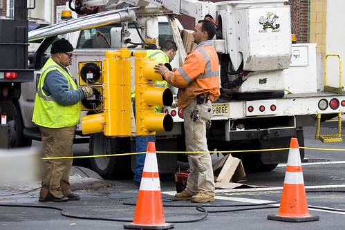
As your humble narrator scuttles from place to place, turning over rocks to see what blind albino abnormalities might lurk beneath, a significant amount of road construction is encountered. New York is always in a state of near collapse and an army of municipal and contractor labor is kept busy filling in the cracks. Conflicted over sneaking pictures of these folks, I nevertheless find them fascinating, for the high visibility colors they wear excite the eye.
from workzonesafety.org
Title: ANSI/ISEA 107-2004: Revised American National Standard for High-Visibility Safety Apparel and HeadwearAbstract: This standard provides a uniform, authoritative guide for the design, performance specifications, and use of high-visibility and reflective apparel including vests, jackets, bib/jumpsuit coveralls, trousers and harnesses. Garments that meet this standard can be worn 24 hours a day to provide users with a high level of conspicuity through the use of combined fluorescent and retroreflective materials. The revised version of the standard expands the product coverage to include high-visibility headwear. It also contains additional testing procedures for knitted fabrics used as background material, and eliminates tests from the previous edition that added no value. Publisher: International Safety Equipment Association

Third Avenue Manhattan – photo by Mitch Waxman
If it won’t blind or distract the crews, don’t forget that this is heavy industry and quite dangerous work, try turning on the camera flash when photographing them. The reflective fabrics, technically retroreflective fabrics (which function like a Cat’s eyeshine), will blaze up and be the brightest point in the photo. New York City street signs also function in a similar fashion, and even the weakest flash will light them up from blocks away. Try it, especially on a dark and stormy day, the effects are somewhat unpredictable and often produce a prismatic and surreal photo.
from simplifiedsafety.org
Class 1: needs to be conspicuous and use retroreflective materials not less than 25mm in width.
- Used when workers are well separated from traffic
- Vehicle speeds of less than 25 mph
- Parking attendants
- Shopping cart retrievers
- Warehouse workers
- Roadside/sidewalk maintenance workers
- Delivery vehicle drivers
Class 2: maintains superior visibility and are more conspicuous than the Class 1 garments. Minimum width of retroreflective material used on these is not less than 35mm.
- Used when workers are on or near roadways
- Vehicle speeds of 25 to 50 mph
- Roadway construction workers
- Utility workers
- Survey crews
- Law enforcement personnel
- Crossing guards
- High-volume parking lot or toll-gate attendants
- Airport baggage handlers and ground crews
- Railway workers
- Emergency response personnel
- Accident site investigators
Class 3: has greatest visibility. Maintains more retroreflective material than Class 2 and must have sleeves with retroreflective material between the shoulders and elbows. Not less than 50mm wide of retroreflective material.
- Used for workers in high risk situations
- Allows them to be seen from a minimum distance of 1,280 ft.
- Vehicle speeds of greater than 50 mph
- Roadway construction workers
- Utility workers
- Survey crews
- Emergency response personnel

31st street, Astoria – photo by Mitch Waxman
All of the municipal and construction rules are meant to conform to the national OSHA specifications, but individual city organizations have their own wrinkle on safety gear. MTA workers, for instance, are often observed wearing goggles and ear protection as they work. No doubt, this is due to individual union agreements and task specific requirements.
from nysdot.gov
All DOT employees, contractor employees and visitors must wear protective helmets and high visibility construction apparel while working within a highway right of way or contract limits. Flaggers must wear high visibility traffic control apparel when directing or spotting traffic. High-visibility apparel is not required for employees and visitors when they are within a completely enclosed cab constructed of steel frame and glass, or inside a motor vehicle.

37th avenue, Dutch Kills – photo by Mitch Waxman
NYFD, of course, has the most stringent series of rules for its crews. In the shot above, a 5 alarm fire at an industrial warehouse was belching black smoke into the street, but the firefighters are clearly identifiable through the murk- due to camera flash. Be careful around NYFD however, as they’re kind of busy people, and you don’t want to distract them. Also, should there be any piezoelectric activated equipment in use- DO NOT use your flash for fear of activating something.
from fasny.com
Back in November of 2008, there was a lot of confusion about the use of high-visibility vests at roadway incidents due to a new Federal Highway Administration (FHWA) Rule. The new regulation, Rule 634, stated that “All workers within the right-of-way of a Federal-aid highway who are exposed either to traffic (vehicles using the highway for purposes of travel) or to construction equipment within the work area shall wear high-visibility safety apparel.”
That regulation created a dilemma for fire departments who were truly interested in protecting their personnel. The training classes and material used by the Emergency Responder Safety Institute (ERSI) for years has suggested the use of high-visibility garments for public safety personnel when working around traffic. NFPA 1500, the Firefighter Health and Safety Standard has included a requirement for firefighters to wear safety vests at traffic incidents in the last two most recent editions. NIOSH Line of Duty Death Investigations have also included recommendations for responders to wear highly visible flagger vests when exposed to moving traffic. In the fire service community it was generally understood that the vests were not appropriate personal protective equipment (PPE) for personnel who were actively engaged in firefighting operations because those garments are not designed for exposure to fire, heat flame or hazardous materials. Rule 634, as originally published however did not outline any exemptions for firefighters engaged in direct firefighting operations and that created the dilemma.

Bridge Plaza North, Queens Plaza – photo by Mitch Waxman
The shot above is fascinating to me, for reasons that have little to do with the safety equipment exhibited. The trench that this trio is working in is down by Queens Plaza, and the cutaway shows a historical record. Notice the top layer of asphalt, then two distinct layers of cobblestones, then dirt and rock fill. Asphalt- modern, cobbles 1- the construction of the Queensboro bridge and associated roadways, cobbles 2- the pre bridge street, dirt and fill- that’s a 19th century, civil war era street. I’d love to have an archaeologist sift through this trench, but there’s nothing of historic importance in Queens… according to the City.
Note- the Charles Rudebaker wiki quote below… I’m a little squirrely on this particular wikipedia entry. The only info I could find on Rudebaker, a New Yorker who supposedly invented the Traffic Cone, parroted this exact wording all across the net. Take it with a grain of salt, until I can find out more. It very well might be a “false meme” which is a sort of “Lulz“.
from wikipedia
Traffic cones, also called road cones, highway cones, safety cones or construction cones, are usually cone-shaped markers that are placed on roads or footpaths to temporarily redirect traffic in a safe manner. They are often used to create separation or merge lanes during road construction projects or automobile accidents, although heavier, more permanent markers or signs are used if the diversion is to stay in place for a long period of time.
Traffic cones were invented in 1914 by Charles P. Rudebaker. Although originally made of concrete, today’s versions are more commonly brightly-coloured thermoplastic or rubber cones. Not all traffic cones are conical. Pillar shaped movable bollards fulfil a similar function.
false awakenings

– photo by Mitch Waxman
The other night I dreamt that I walked over a river.
A former trolley car track on the Queensboro Bridge has been transformed by the City Fathers into a combined pedestrian and bicycle ramp, allowing non vehicular egress to and from the Shining City via Queens Plaza. This is not news of course, as thousands march and pedal across the steel and asphalt lane daily, and many of New York’s bridges allow similar crossings. A firm tenet of this, your Newtown Pentacle, is that you cannot see (really “see”) anything from a moving vehicle or train. You must walk, or scuttle, to truly observe the City.
from wikipedia
After years of decay and corrosion, an extensive renovation of the Queensboro Bridge was begun in 1987 and is still in progress, having cost over $300 million.
The upper level of the Queensboro Bridge has four lanes of automobile traffic and provides an excellent view of the bridge’s cantilever truss structure and the New York skyline. The lower level has six lanes, the inner four for automobile traffic and the outer two for either automobile traffic or pedestrians and bicycles. The North Outer Roadway was converted into a permanent pedestrian walk and bicycle path in 1999.
The Manhattan approach to the bridge is supported on a series of Guastavino tile vaults which now form the elegant ceiling of the Food Emporium and the restaurant Guastavino’s, located under the bridge. Originally, this open air promenade was known as Bridgemarket and was part of Hornbostel’s attempt to make the bridge more hospitable in the city.
In March 2009, the New York City Bridge Centennial Commission sponsored events marking the centennial of the bridge’s opening. The bridge was also designated as a National Historic Civil Engineering Landmark by the American Society of Civil Engineers during the year of its centennial anniversary.
The Queensboro Bridge is the first entry point into Manhattan in the course of the New York City Marathon and the last exit point out of Manhattan in the Five Boro Bike Tour.

– photo by Mitch Waxman
This little excursion, perambulating from Manhattan across the Great Machine’s central artery, was performed on a Tuesday after visiting medical personnel located at Union Square. The Manhattan section of the walk home to Astoria was vague, pedantic, and boring- the City just isn’t fun anymore. During my lifetime, the 45 blocks of Third Avenue transversed would have brought encounters with Junkies, Gangsters, Whores, and a series of intriguing book shops.
The scene today is wholesome, a pedantic stretch of mercantile resellers and upscale restaurants- interspersed by ATM locations. An interesting bit of trivia about Third Avenue, by the way, is that the reason that Bars and Saloons seem to be clustered around certain corners (terty terd and terd) is that their locations vestigially correspond to stops on the Third Avenue El. It’s also why Third seems so widely sited as compared to the other North South streets on the East Side of Manhattan.
from nycsubway.org
The east side branch of the New York Elevated Railroad fulfilled part of the promise of rapid transit yesterday by beginning to run trains from the South Ferry to the Grand Central Depot in Forty-second street. All matters had been thoroughly arranged before the first trip was made; the exact running time that the new engines could make was decided upon and a schedule had been carefully arranged. There were but few stations, however, at which passengers were picked up and dropped. Those were at South Ferry, Hanover square, Fulton street, Eighth street and Forty-second street. The first trip was made from South Ferry to Grand Central Depot at 5:30 A. M., and the distance traveled in twenty-five minutes.
A reporter of THE WORLD road on a train that left South Ferry about 1 P.M. This station is a common one for both branches, and many crowd in waiting started for the door when the agent called out “All passengers for the east side or Third avenue.” There were two handsome cars on the train of maroon color, touched with gold and light paints, and glistening with varnish. The engine also was new and was provided with a regular locomotive cab. The cars within were finished entirely in wood, the seats being of perforated pattern now so common, and running lengthwise of the car. The roofs were slightly decorated, and there was an appearance of neatness without the attempt at elegance of the Metropolitan road.

– photo by Mitch Waxman
Moving east on the Queensboro, one is always prompted to view the sum total of millions of hours of labor, which is called Manhattan (the Shining City). Cumulative, this enterprise called New York City is the end product of a supply chain that stretches across North America and all the way to the fabled Orient. This chain of supply requires distant farms, Canadian coal mines, Pennsylvanian steel mills, and Gulf Coast oil refineries to sustain the population of the Shining City.
At any given moment, on any given day, armadas of commercial goods are in motion toward New York City. On the eastern side of the island, the FDR drive snakes across the riverfront, carrying a ludicrous amount of vehicular traffic north and south across the island, connecting mighty Triborough to the ancient warrens of the Battery at the southern end of the island.
from nycroads.com
PLANNING AND CONSTRUCTION IN THE PRE-WAR ERA: In the 1920’s, public officials and business leaders in New York City proposed waterfront highways along both the Hudson River and East River. The Regional Plan of New York and Its Environs, which was released in 1929 by the Regional Plan Association (RPA), called for a depressed express highway – called the “Chrystie-Forsyth Parkway,” the precursor to the FDR Drive – along the East Side. The tenement districts along the East Side were to be replaced by high-rise buildings housing offices, stores and apartments. To maximize light and air, the widely spaced skyscrapers were to be separated by low-rise buildings and parks.
Robert Moses, arterial coordinator and parks commissioner for New York City, established his vision for the East River Drive: it was to feature six 12-foot-wide lanes, long viaducts for grade separation, and landscaping and parks between the parkway and the river. While the parkway did not have shoulders, it did have emergency pull-off ramps for disabled vehicles. Moses’ riverfront parkway was to connect lower Manhattan with the proposed Triborough Bridge.

– photo by Mitch Waxman
Near the equinox of the bridge, somewhere over- Blackwell’s… Welfare… oops- I meant Roosevelt Island- the occluding fencing of the pedestrian walkway allows a few openings large enough to stick a lens through, and intriguing details of the East River north of the Great Machine can be observed. Don’t forget to witness the locus of this Great Machine itself, with its cantilevered and geared steel persevering the weight of subways, trucks, auto traffic, and the pressure of the wind. There has always been something about the raw engineering of this structure that has appealed to me, one can almost see the lines of force dancing across the painted alloy.
the boweryboys have a fantastic and enjoyable podcast available on Roosevelt Island, and have posted a great collection of photos and (believe it or not) video from 1903 featuring Roosevelt Island that can accessed by clicking here.

– photo by Mitch Waxman
Gaze north, toward the extants of noble Astoria, and witness the diminutive Roosevelt Island Bridge with Hells Gate and mighty Triborough beyond. Recent events have revealed that this vista will be obliterated in the next ten years, as a shield wall of tower buildings have been sited and are in preliminary stages. The single large building in the shot is the Shore Towers building, a pygmy compared to what is coming.
note:
(Pygmy, like Esquimaux, is a somewhat racist term which is falling out of favor for describing ethnic groups of small stature. The African Pygmies, I am led to believe- prefer Aka, Baka, Mbuti, or Twa. Outsiders in Central Africa refer to them as Bambenga or Byaka. People of European cultural heritage, myself included, have a bad habit of giving things we don’t understand or fear pejorative names that we can understand- which makes us feel better about being afraid. Hence the colorful racial thesaurus of the northeastern United States in which there are at least 5 names for every ethnicity, and the reason why we “Americans” tend to refer to the UK as England, the Hellenic Republic as Greece, Zhōnghuá Rénmín Gònghéguó as China, and Bundesrepublik Deutschland as Germany. It’s “why they hate us”, ultimately.)
from nycroads.com
HISTORY OF ROOSEVELT (WELFARE) ISLAND: What is known today as Roosevelt Island was first purchased from the Algonquin Indians in 1637 by the Dutch, who promptly renamed the island “Varckens Eylandt,” or “Hog Island.” In the 1660’s, the British reclaimed the island from the Dutch after years of dispute. The island was granted to Captain John Manning, the sheriff of New York. In 1673, Manning was sentenced to death (later commuted to life imprisonment on the island) for relinquishing New York’s Fort James to the Dutch without a shot.
When Manning died in 1686, stepdaughter Mary Manningham renamed the island after her husband, Robert Blackwell. Blackwell Island remained in private hands until 1828, when the City of New York purchased it and transformed it into a setting for mental institutions, hospitals and prisons. Reflecting this setting as a repository for the down and out, the city renamed the property Welfare Island in 1921.
PROVIDING ACCESS TO THE ISLAND: Initially, access to Welfare Island had been through a series of ferries from Manhattan and Queens. In 1930, a four-cab elevator service began between the lower deck of the Queensboro (59th Street) Bridge and the island. The service, which had served 230,000 cars per year by the early 1950’s, provided the only public connection to Welfare Island.
The increasing traffic needs to and from Welfare Island, as well as growing congestion on the Queensboro Bridge, prompted the New York City Department of Public Works to propose a new vertical-lift crossing between Queens and Welfare Island. After initial resistance from the New York City Council, which doubted that the $6.5 million span would carry enough traffic to justify its cost, construction of the Roosevelt Island Bridge (then named the Welfare Island Bridge) began on March 17, 1952.

– photo by Mitch Waxman
Glancing south, Corbusier’s monolith casts its pale reflections, and the shining city stretches off to the Battery. This is a difficult viewpoint though, as the lanes of lower level bridge traffic are just yards away, and speeding vehicles occlude the perspective. Anyway, who cares about Manhattan anymore? Its nightlife has become a playground for those whom we in Brooklyn used to refer to as driving “Dadillacs” (daddy’s Caddy), and to reiterate- it’s just not fun anymore.
from nytimes.com
The six-story walk-up at 339 East 94th Street has seen much over the decades: generations of mostly white and Hispanic immigrants, nests of mice, drug deals, a police bust, at least one stabbing, a recent influx of young professionals, and a future presidential candidate: Barack Obama.
In his memoir, “Dreams From My Father” (Three Rivers Press, 1995), Mr. Obama described his Yorkville apartment, on East 94th Street between First and Second Avenues, as “part of the shifting border between East Harlem and the rest of Manhattan.” He described a scene that will sound familiar to undergraduates and others who scraped by in the seedy and dangerous New York of the 1980s:
It was an uninviting block, treeless and barren, lined with soot-colored walk-ups that cast heavy shadows for the rest of the day. The apartment was small, with slanting floors and irregular heat and a buzzer downstairs that didn’t work, so that visitors had to call ahead from a pay phone at the corner gas station, where a black Doberman the size of a wolf paced through the night in vigilant patrol, its jaws clamped around an empty beer bottle.

– photo by Mitch Waxman
The busy walkway and bicycle ramp on Queensboro has contributed to the general hostility developing in your humble narrator to the biking community. Now, I admit that the young couple in the shot above are breaking the rules and clearly walking in the bike lane, but they’re in love so let’s cut them a break. However, the aggressive entitlement displayed toward pedestrians by the biking community at large (especially on the Pulaski Bridge) compels me to call for the City to complete the process of normalizing bicycle commuting as standard vehicular transportation by requiring licensing, registration, and insurance. If you demand the right to be treated as legitimate vehicle on the streets of New York, you must comply with the law. No sneaking around red lights, charging crosswalks, or use of the sidewalk can be tolerated… imho.
from nyc.gov
Commuter bicycling in New York City has increased by 26% in the last year, building on last year’s unprecedented growth and representing a more than doubling in bike commuting in just the last seven years. The increase comes alongside the expansion of the City’s bike network, with the number of bike lanes nearly doubled the last three years.

– photo by Mitch Waxman
Incongruously handsome, the Rikers Island prison complex is visible from the bridge, the patina of it’s concrete reflecting the golden liberty lost to those within. A little known fact is that the population of Rikers Island is counted as part of our City Council’s 22nd district here in Astoria, but the inmates are not allowed to vote, rendering a sizeable portion of the actual population mute. I’m not advocating letting felons vote, but apportionment of city and state budgets are based on census data and not attendance at elections.
ERRATA!!! Reader Jayspec points out that this is the Manhattan Psychiatric Center on Ward’s Island, which is somewhat obvious in retrospect. Sorry gang, screwed up again- Mitch
from wikipedia
Rikers Island is New York City’s main jail complex, as well as the name of the 413.17-acre (1.672 km2) island on which it sits, in the East River between Queens and the mainland Bronx, adjacent to the runways of LaGuardia Airport. The island itself is part of the borough of the Bronx, though it is included as part of Queens Community Board 1 and has a Queens ZIP code. The jail complex, operated by the New York City Department of Correction, has a budget of $860 million a year, a staff of 10,000 officers and 1,500 civilians to control an inmate population of 14,000. The official permanent population of the island, as reported by the United States Census Bureau, was 12,780 as of the 2000 census.
The island is named after Abraham Rycken, a Dutch settler who moved to Long Island in 1638 and whose descendants owned Rikers Island until 1884, when it was sold to the city for $180,000. It has been used as a jail ever since.

– photo by Mitch Waxman
Big Allis is quite visible from the bridge, with its busy hive of conduits and valves feeding fuel to its cyclonic turbines. One of the little facts about Queens not being discussed in the current rush to overdevelop the quaint streets of the ancient hamlets of Newtown, which I fear will have dire consequence in the future, is the presence of critical facilities like this amongst large numbers of bourgeois newcomers. Examine the controversies in Long Island City at Hunters Point- the LIRR diesel idling noise (from liqcity.com) complaints, and realizations are beginning to surface in Tower Town that Long Island City is indeed “the Ancient Seat of Graft“.
from nytimes.com
The exhaust fans occupy a squat building that stands at an angle on 50th Avenue in Long Island City, Queens, in a narrow lot surrounded by brush and an iron fence, behind an elegant high-rise building half a block from the East River.
No one denies that they are a necessity: The fans clean the air in a tunnel for the No. 7 subway line when workers are making repairs, something that has happened a lot in the past few weeks and that will continue for several more weeks.
But the problem is that the fans come on without warning, mostly late at night, and stay on for hours, driving people to distraction because the noise makes sleeping virtually impossible.

– photo by Mitch Waxman
Passing the bridge tower driven into Queens, the real droning hum is to be found. Queens Plaza is being painfully reborn, and in as traumatic a manner to the surrounding communities as it can be. The survivors of the late 20th century, stolid holdouts who barred their windows and triple locked their doors- but who stuck out the bad years- are told simply to leave. Their century old homes are bought and paid for as “tear downs” by bonded foreign corporations who have been instructed by City officials to “do what thou wilt, for that shall be the whole of the law”.
Crowleyism seems to have become the governing principle of our republic, and ultimately the logic behind “American Exceptionalism“.
from wikipedia
Thelema roughly means “will” in Greek. The phrase True Will does not appear in The Book of the Law, the central sacred text of Thelema. Nevertheless, Aleister Crowley’s various commentaries on the Book routinely postulate that each individual has a unique and incommensurable True Will that determines his or her proper course in life. This invention of Crowley’s appears to be an attempt to explain how some actions may be wrong (or “false”) when “There is no law beyond Do what thou wilt.” Actions that conform to True Will are thus considered to be correct, while willed actions that deviate from True Will may nevertheless be wrong. In The Book of the Law Crowley wrote “Do What Thou Wilt”.
“DO WHAT THOU WILT” was misunderstood to mean do what you want, however one must consider that a human being is a single machine composed of several parts. So, when one says do what thou wilt , he/she must understand the origin of this will in order to promote or demote its importance. One is formed of a material, mental and spiritual component. These components are all controlled and directed by will that flows through the three and uniting them as one. Initiates of the sacred science are acquainted with the fact of a fourth dimension that is the base of this triad that forms a human being. True will is fourth dimension, that directs the human towards his destiny and forces him into the joy of accomplishing what he/she was meant to accomplish.

– photo by Mitch Waxman
The Great Machine, visible from the high deck of the Queensboro Bridge, beckons your humble narrator to scuttle home before it begins to get dark.
Predatory and fleet, shapes lurk in the sodium lit shadows of the Newtown Pentacle, hungry and weird things that care little for the normal or expected. Feckless, physical cowards such as myself are given to certain spells… vulnerable panics best experienced in one’s own rooms, in the company of my little dog.
That’s when I woke from my dream of walking across a river, in some Shining City with its cyclopean vistas of titan cut stones and sky flung monoliths…
I’m all ‘effed up.
from wikipedia
The categorical view of psychosis is most associated with Emil Kraepelin, who created criteria for the medical diagnosis and classification of different forms of psychotic illness. Particularly, he made the distinction between dementia praecox (now called schizophrenia), manic depressive insanity and non-psychotic states. Modern diagnostic systems used in psychiatry (such as the DSM) maintain this categorical view.
In contrast, psychiatrist Eugen Bleuler did not believe there was a clear separation between sanity and madness, and that psychosis was simply an extreme expression of thoughts and behaviours that could be present to varying degrees throughout the population.
This was picked up by psychologists such as Hans Eysenck and Gordon Claridge who sought to understand this variation in unusual thought and behaviour in terms of personality theory. This was conceptualised by Eysenck as a single personality trait named psychoticism.
Claridge named his concept schizotypy and by examining unusual experiences in the general population and the clustering of symptoms in diagnosed schizophrenia, Claridge’s work suggested that this personality trait was much more complex, and could break down into four factors.
- Unusual experiences: The disposition to have unusual perceptual and other cognitive experiences, such as hallucinations, magical or superstitious belief and interpretation of events (see also delusions).
- Cognitive disorganisation: A tendency for thoughts to become derailed, disorganised or tangential (see also formal thought disorder).
- Introverted anhedonia: A tendency to introverted, emotionally flat and asocial behaviour, associated with a deficiency in the ability to feel pleasure from social and physical stimulation.
- Impulsive nonconformity: The disposition to unstable mood and behaviour particularly with regard to rules and social conventions.


