Posts Tagged ‘Maryland’
Country, early morning
Wednesday

– photo by Mitch Waxman
That’s the Salisbury Viaduct pictured above, which used to be a rail trestle but is now a part of the Great Appalachian Passage trail. Shortly after capturing this shot I bumped into a guy who was hiking from Washington D.C. to Pittsburgh via the GAP route. Nice fellow, European accented.
He had a clever accommodation regarding the carrying of his hiking and camping gear, which included a tent and other outdoor necessities, which was the modified baby buggy that was his companion. The seat of the thing was removed, and the three wheeler carriage seemed to be doing the ‘carrying job’ for him quite well.
Neat.

– photo by Mitch Waxman
The viaduct itself offers a nearly bird’s eye POV on a fairly rural area complete with farms. To this kid from Brooklyn, these sorts of places are like visiting a foreign country and offer a lifestyle which is utterly unknown.
At any rate, it was time to head back to the car and get back to the road trip for me. I was heading towards a train yard which has been on my radar, and I had worked out a spot which was semi public where I’d be able to wave the camera around, without the threat of meeting either the local gendarmes or surly locomotive security personnel.
There are Woody Guthrie songs about the latter circumstance. Always a good idea to follow Woody’s advice.

– photo by Mitch Waxman
I enjoy seeing the line of windmills up on that hill. Political back and forth notwithstanding, it’s silly to not harvest wind energy and convert it into profitable electrical supply. One of these days somebody will wake up and say ‘hey, the rivers and oceans offer a somewhat limitless supply of waveform energy…’ but…
What, you’re going to leave something that’s basically free on the table?
Back tomorrow.
“follow” me on Twitter- @newtownpentacle
Buy a book!
“In the Shadows at Newtown Creek,” an 88 page softcover 8.5×11 magazine format photo book by Mitch Waxman, is now on sale at blurb.com for $30.
Emperor’s new clothes
Tuesday

– photo by Mitch Waxman
Occasion recently found a humble narrator on a short road trip, and heading towards Western Maryland. Just a few miles after crossing the Mason Dixon line, I decided to take a break from the effort at the Salisbury Viaduct, and soon after walking onto the structure I heard the horn, and rumble, of an approaching locomotive.
It was Amtrak, and I was lucky enough to get a shot of one of their locomotives all done up in the new color way and trade dress that the passenger service has recently debuted.

– photo by Mitch Waxman
I suspect that this unit was ultimately heading to Washington D.C., as it was passing through the panhandle of Western Maryland. I’m speculating here, but I’d also suggest that this train likely started its trip in Chicago in the dead of night.
Luckily, I had installed a ‘crop sensor’ lens on my camera which allowed for a 300mm zoom range. I was barely in position for this one, but managed to crack out these three shots as the train rolled past.

– photo by Mitch Waxman
Pleasing, the new design is, one declares. Supposedly, the entire fleet will be receiving similar paint jobs in the next few years.
Back tomorrow.
“follow” me on Twitter- @newtownpentacle
Buy a book!
“In the Shadows at Newtown Creek,” an 88 page softcover 8.5×11 magazine format photo book by Mitch Waxman, is now on sale at blurb.com for $30.
Walking the line
Thursday
– photo by Mitch Waxman
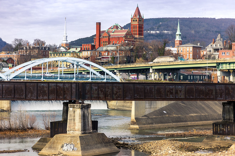
Cumberland, Maryland. I’ve been here before, as detailed in these posts. I was kind of going for a post card look in the shot above. Didn’t have to use filters or anything to make the water look reflective and mirror like, as the entire region had been down in single digit temperatures the night before, and there was lots and lots of ice on the water.
This is the mouth of the C&O towpath canal, which is discussed in one of the prior posts in the link above.

– photo by Mitch Waxman
The emergent problem encountered, for a humble narrator, is that when you drive to place a hundred miles away you’ve also got to drive back home. The four hours of travel time seriously truncates photographic possibility, shortens the tenure of how long you’re willing to spend exploring, and causes you to question why you committed the time and gasoline to the endeavor.
This visit is part of my continuing attempts to visit and familiarize myself with the satellites of the Pittsburgh centered Megalopolis. Oil City and Titusville to the north, Wheeling in West Virginia, Cumberland in Maryland – all have been witnessed.
I’ve got a portfolio of future destinations – Morgantown in West Virginia, Cleveland in Ohio, Erie in Pennsylvania, all over this joint.
Cleveland and Erie, in particular, will require overnight stays due to distance and the length of the drive there. Definitely don’t want to execute a roughly 5 hour drive, and then have to just turn around and head back to HQ.
– photo by Mitch Waxman
That’s the North Branch of the Potomac River pictured above, with the left side of the shot in Maryland, while the right side is West Virginia.
Also, I should mention that as I’m old, I absolutely loathe driving at night – when adolescents prowl the interstates in Pickups, with no regard for law or custom. Additionally, you’ve got the ‘deer situation’ and ‘no street light dealie’ to handle out here. Brr.
As far as the aforementioned ‘deer situation,’ it is amazing how many ruminant corpses you’ll notice while driving along hereabouts, laying in shattered form alongside the roads.
Back tomorrow with more adventure for a strange man, in this strange land.
“follow” me on Twitter- @newtownpentacle
Buy a book!
“In the Shadows at Newtown Creek,” an 88 page softcover 8.5×11 magazine format photo book by Mitch Waxman, is now on sale at blurb.com for $30.
Western Maryland Scenic Railroad
Thursday

– photo by Mitch Waxman
As detailed in earlier postings, a humble narrator left HQ in Pittsburgh in the early morning hours and piloted the Mobile Oppression Platform along a southeastern vector towards the panhandle section of Western Maryland, and specifically the City of Cumberland where my ‘turn around’ point was. Throughout the morning, I had kept “11:30 a.m.” in mind, since that’s when the Western Maryland Scenic Railroad would be offering a tour on their heritage railway with its historic rolling stock. There’s also a fairly large CSX railyard in Cumberland, but halfway through the morning I had decided that I’d be coming back this way again and would leave that one for ‘next time.’ This location is about 85 miles from HQ, which ends up being about a two hour drive if you don’t make multiple stops along the way, as I did.
I wasn’t going to be riding with WMRR on this day, but plenty of other people were. The Heritage RR operation offers fairly regular excursion tours between its 1913 Cumberland Station and the community of Frostburg. During the holiday season, they use an actual steam engine and fashion the trip along a Christmas theme as “The Polar Express,” as you’ll see in this particularly well shot YouTube video from Blue Comet Productions.

– photo by Mitch Waxman
After finding a solid place to leave the car, one set out on foot and got busy. As mentioned, this wasn’t the day which I’d be purchasing a ticket and riding on the thing. Saying that, they have California Zephyr Dome cars in addition to executive lounge cars attached to the engine, as well as an ‘open car’ about which their website description offers the caution that you WILL get cold, wet, and dirty while riding in. That’s the photographer centric one, as there are no windows. You can also pony up a few extra bucks if you want to ride in the locomotive engine with the engineer at the head of the snake.
The origins of the Western Maryland Railroad date back to 1852, and like all history associated with rail – there’s a complicated series of corporate owners, partnerships, mergers and acquisitions, and incremental expansions which you can sort out for yourself at this Wikipedia page. Ultimately, in 1973, the WMRR was incorporated into the ‘Chessie System’ which would later merge with an outfit called Seaboard Coast Line Industries in 1982. The combined outfit would rebrand itself in 1987 as CSX.

– photo by Mitch Waxman
After the merger in 1987, CSX abandoned the Cumberland to Frostburg tracks and several municipal entities (including Cumberland and Frostburg and the counties they reside in) foresaw creating a tourist attraction so they purchased the corridor and several of the yards and facilities owned by the WMRR in 1988. It runs regularly scheduled tourist trips in modernity.
Right on schedule, at 11:30 a.m., the guy with the flag arrived and stopped automotive traffic. The signal bells started ringing, and the train blew its horn. Me? I was standing on the concrete of the C&O Canal’s tow path (described yesterday), which adjoins the rail tracks.

– photo by Mitch Waxman
The steam engine which they’re so famous for was in the shop, and the WMRR was instead running a diesel engine at the front of the train. It’s a General Electric Dash 8-32B model #558, which used to be a part of Norfolk Southern’s fleet, and has been leased from that entity to the WMRR as of September of 2022. It’s painted in WM’s color way and heraldry.
My original intention for this leg of the day trip was to linger around Cumberland for a while, and see what I could get at the nearby CSX yard, but I’d been actively ‘doing my thing’ since 5 in the morning and was beginning to feel fatigued.

– photo by Mitch Waxman
Saying that, I’d actually had a full morning. I was at The Great Cross in Jumonville, the Youghiogheny River Lake, and there were a couple of other stops I had made along the way which weren’t all that productive. I still had a two hour drive to get back home, and unlike the morning journey, this time I’d have to contend with traffic and worst of all – school buses. It’s eminently logical to legally forbid the bypassing of school bus traffic, but when you find yourself behind one on a one lane country road… you’re just screwed.
I’m definitely coming back to Cumberland, and plan on riding with them on that Polar Express dealie. Unmentioned in this post, so far, has been the presence of the Great Allegheny Passage bike and pedestrian pathway. The GAP is the same trail that starts in Pittsburgh, which I’ve mentioned many times. An absolutely terrific number of people were observed unloading road bikes to take advantage of the trail, in the municipalities parking lot, where the Mobile Oppression Platform was waiting for our return trip to Pittsburgh.

– photo by Mitch Waxman
After the WMRR rode out of view, I returned to the car, and changed up my camera gear to traveling mode. A quick stop at a gas station was accomplished where the car was fueled up, where I got some much needed coffee, and away we went. On the way home, I stupidly followed a route, suggested by Google Maps, which added a half hour and about thirty miles onto the trip. By the time I was back in Pennsylvania’s Uniontown section, that salami sandwich I had eaten for breakfast was utterly metabolized and I needed a lunch break. McDonald’s, if you’re curious. Here’s a tip – the double quarter pounder is a Big Mac without the special sauce (which you can request they add) and it’s about $5 cheaper than the flagship sandwich.
One of my practices while traveling is to uncharacteristically eat such forms of fast food, since doing otherwise means that you’re kind of throwing the dice as far as food poisoning goes with unfamiliar roadside restaurants. McDonald’s corporate is famously hardcore in terms of enforcing health and safety rules on their franchisees – in terms of “quality,” food storage and cooking temperatures, and facility cleaning standards, so… it ain’t good for you – at all – but McDonald’s ‘fills the hole’ and probably won’t give you a case of the squirts. I learned this lesson about grabbing an ‘on the go’ meal when I was still drawing comics, and had to drive to and attend comic conventions all over the country to promote the books.
After washing the fry and burger grease off my hands, it was time to finish the trip back to Pittsburgh. I think I walked back into the house at about 3:30 p.m.
Whew. Back tomorrow, at this – your Newtown Pentacle.
“follow” me on Twitter- @newtownpentacle
Buy a book!
“In the Shadows at Newtown Creek,” an 88 page softcover 8.5×11 magazine format photo book by Mitch Waxman, is now on sale at blurb.com for $30.
C&O Canal Towpath
Wednesday

– photo by Mitch Waxman
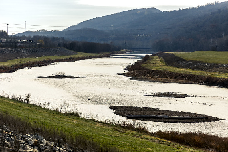
The extant location which I’d been heading towards all morning, after leaving Pittsburgh at about 5 in the morning, was in Cumberland, Maryland. Pictured above and below is the C&O canal, aka the Chesapeake & Ohio canal, aka the ‘Grand Old Ditch.’ This wasn’t what I had traveled for, but what? I’m going to ignore it? Pfah.
The C&O Canal extends from Washington D.C. to Cumberland, some 184.5 miles. Its construction began in 1828 (inspired by the early success of ‘Clinton’s Folly’ in New York), there are 74 locks along its length, and its current status is that of a National Park. Its designed function was to provide a transportation pathway for coal, mined out of the Appalachian region in the ‘panhandle’ of Western Maryland and Southwestern Pennsylvania, to markets and industry in the nation’s Capital and surrounding area.
The C&O canal was completed in 1850, but was already redundant the day that the ribbons were cut as the Baltimore & Ohio Railroad had gotten here first in 1842.
Chesapeake Bay on the Atlantic Seaboard, however, was connected to mountain girdled Cumberland via this canal, which was a historic infrastructure project originally proposed and championed by George Washington and ultimately funded during the Presidency of James Monroe. The original plan for this canal was to connect all the way to the Ohio River near Pittsburgh, but the rail people had already out competed the canal people on that one, and the Cumberland to Pittsburgh/Ohio River section never happened.

– photo by Mitch Waxman
I’m willing to go out on a limb here, and predict that 100 years from now the United States will be revisiting this sort of intra city cargo transportation methodology in the post fossil fuel era. The way that these canals worked involved using pack animals walking on a tow path which were harnessed to long boats or barges, providing motive power to these vessels and floated along on the captive water.
The boats which used this canal were specified as being no more than 90 feet stem to stern, with a beam (width) of 14.6 feet.
A modern day 40 TEU cargo container’s dimensions are 40′ long x 8′ wide x 8′ 6” high, so…
It won’t be donkeys hauling any 22nd century cargo boxes around, however, instead it’ll likely be some sort of unmanned electric tractor tied off to the barges which will move at a fairly slow but steady pace. The drainage ditches along the interstate highway system should provide a good idea of where such canals will be constructed. These canals would also be handy infrastructure to have, for overflow during heavy rainfall and springtime floods, as well.

– photo by Mitch Waxman
Cumberland itself is a city of about 20,000 people found along the Potomac River, and the Cumberland Metro area has about 100,000 people in its extended territory. Found on the other side of the North Branch of the Potomac River in this area is West Virginia. Cumberland was a jumping off point for overland expeditions in the post American Revolution period, has a storied industrial past, and like much of the Appalachian region – has been in a financial and demographic free fall since WW2. There are 318 metropolitan areas – as identified by the Federal Government – in the United States and Cumberland ranks as #305 in terms of wealth. Average median income in Cumberland for a single earner household is just $25,142, and for families it’s $34,500. That’s the 50% mark, I’d point out, as in half of the population scratches by on less than those numbers. Close to 20% of the population in Cumberland lives below the Federal Poverty line, and the city is regionally infamous for high levels of opiate addiction. The population has been declining steadily since 1950, and over the course of the last half of the 20th century it lost several of its major industrial employers. Observationally, it wasn’t all that bad, but I was visiting the city center and historic district – not driving around up in the hills and neighborhoods where these conditions exist.
The good news here is that they have some of the most inexpensive real estate on the east coast of the United States, and that their cost of living is the sixth lowest in the entire country. Saying that, I can now tell you from experience that whereas your rent burden is far lower in this region than it is back in NYC, everything else costs the same – health insurance, services like internet and telephone, all that.
Now, you know I didn’t leave the house at 5 in the morning just to take a few pics of an empty but historic canal, right? Wait till you see what else Cumberland has going on, in tomorrow’s post at this – your Newtown Pentacle.
“follow” me on Twitter- @newtownpentacle
Buy a book!
“In the Shadows at Newtown Creek,” an 88 page softcover 8.5×11 magazine format photo book by Mitch Waxman, is now on sale at blurb.com for $30.


