Posts Tagged ‘Monongahela River’
High over Pittsburgh
Monday
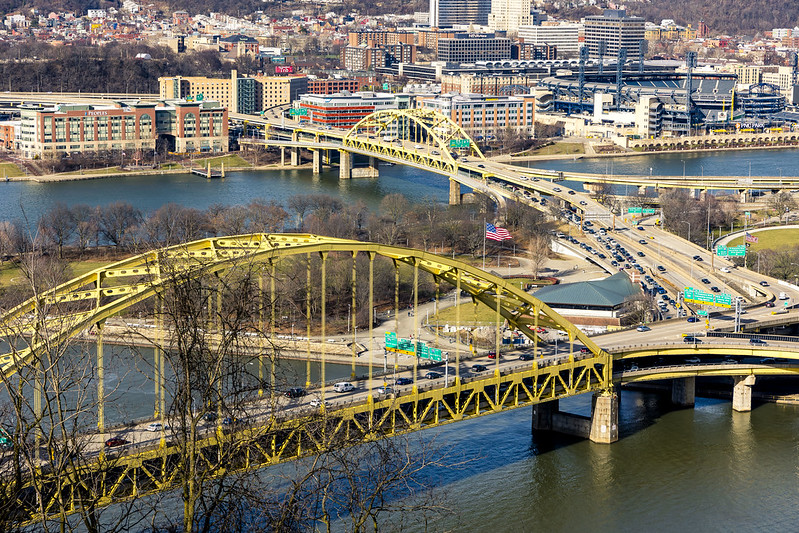
– photo by Mitch Waxman
Last week, an unusually warm February day found a humble narrator marching around Grandview Avenue on Mount Washington here in Pittsburgh. This street sits on a ridge overlooking Downtown Pittsburgh and the Monongahela River, and it’s bookended by the two inclines – Allegheny and Duquesne. The views from up top are fairly killer, and it should be mentioned that I’ve been here up before. There are overlook platforms, and a sort of linear park which is well used by the public, along Grandview Avenue.
The bridges in the photo above are the Fort Pitt and Fort Duquesne Bridges, both of which were recently walked over and described.
– photo by Mitch Waxman
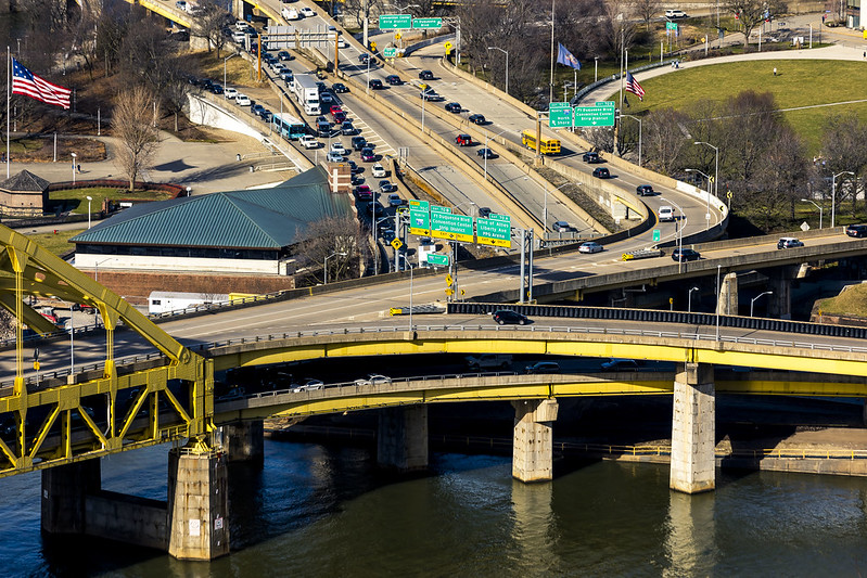
One is – as always – fascinated by the massing shapes and parabola of the access ramps leading to and from the bridges. The water is the Monongahela River, and this is nearby the titular end of the 130 mile long waterway where it combines with the Allegheny River and the combination transmogrifies into the Ohio River.
Wanderings over the last couple of months have seen me stitching around, exploring. One was feeling the need to come back to square and reconnoiter from above.
– photo by Mitch Waxman
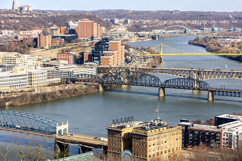
Looking up the Monongahela River, in the foreground is the Smithfield Street Bridge and the P&LERR building. Next up is the Panhandle Bridge which carries the T light rail into Downtown. Behind that is the Liberty Bridge, and the yellow one is the South Tenth Street Bridge. In the distance, you can see the Birmingham Bridge.
All along the waterfront are ‘rail to trail’ public spaces. Between Birmingham Bridge and South Tenth Street on the north side of the river is the Eliza Furnace Trail, for instance, with the Hot Metal trail found in the south side of the water.

– photo by Mitch Waxman
The T is seen crossing the Panhandle Bridge in the one above. I’m planning on putting some time and spending some shoe leather on this section of the world this week, so stay tuned for that one.
I’m also planning on heading further out, specifically returning to Clairton and the trailhead of the Montour Trail found directly across the street from the sense shattering US Steel mill found in that community. I’m also planning on walking another section of the Great Allegheny Passage trail which should provide great views of USS’s Mon Valley Works in Braddock from across the river.

– photo by Mitch Waxman
This one looks back along the steep slope of Mount Washington, where the trees are still very much in their winter time hibernation mode.
Since the start of the year, there’s been a couple of very high profile crimes which resulted in the shooting death of two Police Officers in separate incidents, here in the greater Pittsburgh area, and thereby the flags have been flying at half mast throughout the City.
– photo by Mitch Waxman
One spent a couple of hours marching back and forth on Grandview Avenue, during the late afternoon. The day was coming to an end, and I wanted to do a few tripod shots, but desired to capture a less common point of view. One headed back to the Mobile Oppression Platform (my pet name for the Toyota) which had been parked at a metered spot midway twixt the two inclines, and headed towards my next destination.
The good news is that I’m finally getting comfortable with having a car be a part of the equation. Compared to having to drag ass back to HQ after walking around NYC and getting on the Subway to discover MTA is having yet another meltdown and “you can’t get there from here” it’s a real pleasure to have some personal agency in terms of getting from A to B.
Back tomorrow with what I saw and recorded.
“follow” me on Twitter- @newtownpentacle
Buy a book!
“In the Shadows at Newtown Creek,” an 88 page softcover 8.5×11 magazine format photo book by Mitch Waxman, is now on sale at blurb.com for $30.
There and back again
Thursday

– photo by Mitch Waxman
That’s the Birmingham Bridge which a tugboat is navigating up the Monongahela River under, here in Pittsburgh. Where the bridge comes back to land on the southern shore, seen on the right hand side of the shot, is where my car was parked. Due to construction, my original plan to walk across Birmingham Bridge was thwarted, and also due to that project a humble narrator was forced to just keep on going in a generally westwards direction until a river crossing manifested itself. This is from the northern shoreline of the waterbody, and I needed to get to the south side and then back to my waiting automobile.
That’s the quandary. I solved it by doing what I do, which to just keep on walking. Scuttling, actually, but let’s call it walking. Luckily, an apparently quite energetic young woman jogged past me, hopping a couple of feet into the air with every stride, and since she seemed to know where she was going I kept an eye on her path.

– photo by Mitch Waxman
The path which that fitness enthusiast blazed led me directly to the South Tenth Street Bridge, which I’ve actually mentioned before. The bridge connects several levels of the north side area together, including leading up to Duquesne University via a very steep staircase set against a bluff. There’s also a vehicle only tunnel punched through the base of the bluff which leads out to local streets. On the river facing side, you can navigate down to the waterfront and it’s trails, as well as to ‘for pay’ parking lots surrounding several governmental buildings. On the other side of the river, the bridge enters the South Side Flats neighborhood. That’s where I needed to go, to find my way back to the car.
Luckily, protected pedestrian and bike paths on bridges are pretty common hereabouts. One hung a left, and away a humble narrator went.

– photo by Mitch Waxman
It was a pretty pleasant walking experience, actually. Separated from vehicular flow by steel girders, but few chain link sections of fencing. One of my most sincere complaints about NYC DOT’s Bridge operations revolves around the prison yard fencing that they throw up everywhere they can. One of my proudest moments along Newtown Creek was convincing the NYS DOT not to chain link the new Kosciuszcko Bridge and instead install a model of fence which didn’t occlude the views. I talked them into creating a fence not dissimilar to the one surrounding Calvary Cemetery, arguing about visual continuity with the designers. It’s just a coincidence that the width between the bars of that fence happen to be 1/2” bigger than the barrel of my favorite lens. Coincidence, I say.
It’s only about 1,200 feet across, the South Tenth Street bridge, so it’s a fairly quick walk.

– photo by Mitch Waxman
I heard it right about here, I’ll cryptically mention.
The ‘quality rolls’ place in the background was some kind of metals mill, not too sure about what they roll or the quality thereof. As has been the case every time I’ve left the house for the last month, I’m not pretending to myself that I’m going to “photograph” anything (I’ve taken a lot of ‘crime of opportunity’ photowalk “shots”) and that my order of the day continues to be scouting in pursuance of future photo outings which will be more in depth.
Is it a Morning thing? Summer or Fall thing? What time of year do these sticks and twigs flower? All that.

– photo by Mitch Waxman
As mentioned, I heard it back on the bridge. Luckily for me, the crew was stuck at a signal and I had all the time in the world to get into position before they blew the horn and started moving.
I have been extremely unlucky as far as timing goes when it comes to freight rail. That construction detour back on the Eliza Furnace Trail on the north side of the Monongahela River actually set me up. Serendipity, I tell’s ya, serendipity.
That’s a CSX train set, on the Pittsburgh Subdivision. There were tanker cars in the line, but who the hell knows what was in them or maybe they are empty inside. A couple of weeks ago, I saw a photo of a CSX unit towing Army Tanks and military looking container boxcars along these tracks. Was there ammo on board? Who knows? There’s supposed to be a ‘no hazardous material’ rule within the city’s limit, I’m told, but is that enforced? By who? Is there a formal compliance agreement between the carrier and the State or the Feds? Have dirty rotten cheaters gamed the system?
Who knows?

– photo by Mitch Waxman
That derailed Norfolk Southern business in Ohio is about 50 miles away from HQ. I’ve been watching the social media ripples of the event splashing about, and all I can say is that maybe when the Union wanted to go out on strike last month we should have listened to them and the members if Congress shouldn’t have engaged in a rare bipartisan alliance to crush their right to strike. Joe Biden joined a long list of American Presidents who have orchestrated against Labor when the industry involved is Rail – and that includes FDR, Truman, Nixon, Reagan etc. This sort of thing goes beyond party, btw, and has nothing to do with that. It’s national security, supply chain, mega capitalism.
Vital industries depend on rail, and the last thing you’d want to do is increase the amount of volatile material that travels around the USA in trucks. The fact that the sort of disaster which the people in Ohio, just an hour’s drive west of here, are living through is rare and comment worthy is a testament to how good American rail workers are at their jobs, and how robust the American Rail system actually is. The problem right now is success, as in the success of the company in the eyes of Wall Street.
Not enough butter is getting spread over too much bread in the name of growing the profit margin, in order to make Norfolk Southern and CSX look good to the Wall Street hedge fund managers. That’s why corners get cut, maintenance deferred, and the trains and yards are undermanned.
“follow” me on Twitter- @newtownpentacle
Buy a book!
“In the Shadows at Newtown Creek,” an 88 page softcover 8.5×11 magazine format photo book by Mitch Waxman, is now on sale at blurb.com for $30.
Eliza Furnace Trail
Wednesday

– photo by Mitch Waxman
After having crossed the Monongahela River here in Pittsburgh, via the Hot Metal Bridge, one then proceeded onto the Eliza Furnace Trail heading in a generally westerly direction towards Downtown Pittsburgh. In yesterday’s post, I walked on the two other trails found on the south side of the river, and then on one set on the Hot Metal Bridge itself. It’s all very confusing, really, but you get where you want to eventually.
Eliza Furnace Trail is cut through a weird liminal space formed by bridges, highways, industrial activity, and is set against very high ridges and cliffs… wow.

– photo by Mitch Waxman
There’s a maintenance project underway in this spot, involving one of the minor Bridge/Onramp structures weaving about on the north side of Pittsburgh. Workers were up on scissor lifts with concrete and metal working equipment. Scaffolding was in place, as were steel structures acting as drop cloths under the job site.
Pittsburgh is in a constant state of emergency repair, due to the challenging geology and a lack of systemic maintenance during its downward financial spiral at the end of the 20th century. Sinkholes are known to form here, and a few years ago – one opened up downtown and swallowed a city bus. It’s become an unofficial seal for the city, and people sell t-shirts and xmas ornaments of the scene.

– photo by Mitch Waxman
The Eliza Furnace Trail wanders fairly far afield of the Monongahela River’s waterfront. My original plan for this scouting mission was to cross the river at the Birmingham Bridge and circle back to where I’d parked the Mobile Oppression Platform. Problem was that the construction project had obliterated the connection to the bridge and the surrounding streets, so I ended up having to scuttle about a mile further west than intended to get back to the south side. I need the exercise, anyway, so no big whup.
The traffic, the noise of construction, clouds of concrete dust and auto exhaust hanging in the air… it’s like I was back in NYC for a minute.

– photo by Mitch Waxman
A bunch of people whom I’m in telephone contact with have asked “do you miss it?” The answer is “I don’t.” I still feel like I’m on vacation somewhere, but… we now live in a house, on a quiet and somewhat suburban street. The vibe here in Pittsburgh is awesome.
What I do miss is the ability to stagger out the door and walk over to Sunnyside Yards for a few quick train shots, or over to Dutch Kills in LIC for yet another series of loving shots of that unloved industrial canal. I don’t miss the noise, danger, and constant bullshit right under my bedroom window. I have never, ever, had the quality of sleeping that I’m currently experiencing. It’s quiet and dark here at night.

– photo by Mitch Waxman
I’m also quite enjoying the discovery of novel and new here. Back in NYC, I was a dirty rotten “know it all.” Want to know who built the NYC Ferry and where? Which one of Kathy Hochul’s sponsors will profit from her interborough rail plan? Who will get to build those 15 foot sea walls they’re proposing for Brooklyn and Queens, and what it cost them to be the first in line when Congress starts writing checks?
It’s lovely not knowing everything. Saying that, I can already tell you that the green/blue steel is owned by the State of Pennsylvania and that the yellow part is owned by the city of Pittsburgh. At least that’s what I think the different colors mean.

– photo by Mitch Waxman
My walk continued, after having passed under the Birmingham Bridge and the nest of on and off ramps which feed into it. The Eliza Furnace Trail transmogrifies into the Three Rivers Heritage trail and overlays the Great Allegheny Passage trail somewhere around where the above photo was captured. This path ultimately leads the Point State Park on the golden triangle section of Pittsburgh, where the Fort Pitt Bridge can be found.
Point State Park is the de facto center of the Pittsburgh metropolitan area, which encompasses multiple counties and satellite cities, towns, and boroughs in four states – Pennsylvania, Ohio, West Virginia, Maryland. Culturally and financially distinct from the nearby East Coast, Great Lakes, and Toronto megalopolis, one continues to try to wrap his head around this amazing part of the United States which I now call home.
More tomorrow, from the Paris of Appalachia, at your Newtown Pentacle.
“follow” me on Twitter- @newtownpentacle
Buy a book!
“In the Shadows at Newtown Creek,” an 88 page softcover 8.5×11 magazine format photo book by Mitch Waxman, is now on sale at blurb.com for $30.
Hot Metal, 3 Rivers Heritage Trail
Tuesday

– photo by Mitch Waxman
The path which the Monongahela River enjoys is somewhat serpentine in nature, prior to the waterway’s juncture with the Allegheny River, where they mutually become the Ohio River nearby Downtown Pittsburgh. Last week, I drove the Mobile Oppression Platform (the Toyota) over to a neighborhood called the Southside Flats and parked in a lot associated with a park and the Three Rivers Heritage Trail. The MOP was left directly beneath the Birmingham Bridge, pictured above.
It’s a young bridge for this section of the world, having been opened for business in 1977. It’s another bowstring arch bridge, not unlike the Fort Penn bridge discussed last week. The fact that it’s not painted yellow indicates that it’s a state – rather than a city – bridge. My plan for the afternoon was pretty simple – I’d walk eastwards along the trail, cross the river and then walk westwards, whereupon I’d circle back to the MOP. It was overcast in Pittsburgh, with roiling clouds bolting around up in the vault, and the temperatures were comfortable and in the mid 50’s.

– photo by Mitch Waxman
This is another one of the sections of Pittsburgh where there used to be a steel mill, I’m told. The trail itself follows active freight rail tracks on the south side of the river. In tomorrow’s post, the north side of the scene will be explored, but for the first half of my walk it was all about the south side and getting to where my crossing would be found.
There’s gigantic infrastructural elements available for inspection and appreciation along the way – storm sewers, enormous concrete and iron retaining walls that keep the slopes of sedimentary soil deposits from sliding into the river. One section had steel plates holding up a wall of soils, with the steel plates bolted into place with giant lug nuts that were the size of dinner plates.

– photo by Mitch Waxman
That’s the 1887 vintage Hot Metal Bridge. During the Second World War, 15% of American steel production would travel over it on the rails. In 2000 AD, it was converted over to vehicle and pedestrian/bike usage. Its “official” name is the “Monongahela Connecting Railroad Bridge and Hot Metal Bridge.” On the path approaching it, there’s historic signage which describes the steel industry and the railroads which served it.
There’s post industrial development everywhere you look in this zone, and a few large corporate anchors are located nearby, including the clothing company American Eagle Outfitters.

– photo by Mitch Waxman
On the Hot Metal Bridge’s pedestrian path, which is completely separated from the vehicular lanes, and heading north – that’s where this shot was gathered. I didn’t have any particular goal for the afternoon other than kicking my feet about and getting some exercise, but I was able to piece together a mental map of where I was scuttling based around prior explorations – which I’ve described here – of the Monongahela Valley. Locally, it’s referred to as the Mon Valley by the politicians, but when they say that it’s usually in reference to the still quite industrial areas to the east like Clairton and Braddock.
There were just a few other people on the bridge. A bike rider or three, joggers, one or two other pedestrians. No dogs.

– photo by Mitch Waxman
This one looks back towards the south side of the river across the Hot Metal Bridge. My original plan was to circle back to the south side and the MOP using the Birmingham Bridge… but more on that tomorrow.
The north side has quite a different circumstance than the south does, with high speed roads like I-579 riding on elevated structures and an industrial and commercial zone. When you get to the north side, the Three Rivers Heritage trail is renamed as the Eliza trail to commemorate the J&L Steel mill which was located here. This bridge is also part of the Great Allegheny Passage trail.

– photo by Mitch Waxman
On the north side, I turned westwards. The neighborhoods around this intersectional area are Oakland and the Hill District. The terrain here is difficult due to its verticality, and I can tell you that it’s a real challenge to climb these hills on foot. Luckily, the path I was walking on was graded for rail, meaning one foot of elevation for every hundred feet horizontally.
Tomorrow, I find myself walking through the sort of place which most would logically go looking for my corpse, if I’d gone missing.
“follow” me on Twitter- @newtownpentacle
Buy a book!
“In the Shadows at Newtown Creek,” an 88 page softcover 8.5×11 magazine format photo book by Mitch Waxman, is now on sale at blurb.com for $30.
Fort Pitt Bridge, part 2
Wednesday

– photo by Mitch Waxman
As described yesterday, one required a bit of exercise and thereby the Fort Pitt Bridge’s extremely icy pedestrian walkway beckoned. It was literally below freezing out, but a humble narrator was wrapped up tight in winter garb, including a brand new winter coat. A conscious decision was made to travel a bit lighter than usual, with just two lenses and no tripods or other extraneous gear to slow me down. As it turns out, I only needed the one lens (24-105mm).
After crossing over the Monongahela River, the walkway is set onto an elliptical path which eventually brings one back to the sidewalk nearby Pittsburgh’s famous Duquesne Incline.

– photo by Mitch Waxman
Alluding to Tolkien – one lens to rule them all – is what I’ve been missing on the Canon RF mount since I upgraded from my old rig, which was a Canon 7D. The Canon R6 I’m using these days is in all ways a superior digital appliance to the former camera, but there are few if any third party lenses available for it. On the 7D, which is a “crop sensor” model, I almost always had a Sigma 18-300mm zoom lens attached to it for general “photowalk” usage. That lens, and several others in my kit, are designed specifically for the crop sensor and not the full frame chip inside of the R6. This sort of “all in one” range suggests that it would be a crappy lens, but I liked it for its versatility and once you got to know the thing and where and when it failed, it was actually pretty reliable. I find myself using the 24-105 a lot here in Pittsburgh.
Saying that, I’m not unhappy with what I’m getting from the 24-105mm – I mean, it’s a Canon L series lens with a red band and everything – but I miss the option of going from ultra wide to telephoto with just a twist of the lens barrel. Supposedly Canon isn’t licensing the RF mount to anyone right now. That’s a shame, since there’s some pretty amazing glass out there from Sigma and others in the Nikon and Sony mount spaces.

– photo by Mitch Waxman
That’s the Fort Pitt Tunnel that the vehicle traffic is hurtling into. Right around this spot is where I ended up conversing with some bloke about the news of the day and we both landed on how cold it was. There wasn’t too much in the way of pedestrian or bike traffic on this particular afternoon, but it was – after all – January in Pittsburgh.
It has been fairly difficult to get out for my every other day walks for the last couple of weeks due to the January factor. Rain, snow, snow showers, rain, polar vortex, rain…

– photo by Mitch Waxman
When time and opportunity present, though, I get my butt moving! The plan for the rest of the afternoon involved scuttling down the Monongahela River shoreline towards the Station Square “T” light rail stop. This pathway leads into a connection with the Three Rivers Heritage Trail, which is another one of the many (fantastic) rail-to-trail pathways that snake around the city. A couple of weeks ago, the Great Allegheny Passage’s trail in Homestead was discussed – part 1, part 2, part 3.
Just the other day, I was walking down the other side of the Monongahela River, on the golden triangle/city side. You’ll see those shots next week, but that’s where the waterfront trail’s path goes nowhere near the water and you’re separated from it by a massive highway and several waterfront industrial and commercial parcels. I was ecstatic about this, of course, since I got to walk around and photograph the footings of bridges and highways. I’ll show you all that next week, I think.

– photo by Mitch Waxman
We are just about done with the moving process at this point. Furniture is in the house, I’ve now got a Pennsylvania Driver’s License, and have learned about seasonally available regional baked goods. Ever had a Pączki? One is looking forward to spring, exuberantly. The moving process consumed my entire autumn and winter. Y’know, you’d think moving from one state to another would be simple, huh?
The last major process we have to handle involves transferring my car registration and plates over to Pennsylvania ones. When that’s done, major combat operations will have concluded and I will realize the peace dividend of having fewer “have-to’s” listed in my column on a white board somewhere.

– photo by Mitch Waxman
I kept on hoping for a train to roll through, which would have really made the shot above sing. As continually repeated – I’m scouting right now. Figuring out where the shots are, how I get there, what time of day would be best – all that. So far, I haven’t had very much luck as far as timing goes when it comes to freight rail traffic. I’m no train spotter, or railfan as it were, but damn… I wish there had been a CSX train set rolling through for this one.
Tomorrow, a few more shots from my walk along the Monongahela River here in the Paris of Appalachia.
“follow” me on Twitter- @newtownpentacle
Buy a book!
“In the Shadows at Newtown Creek,” an 88 page softcover 8.5×11 magazine format photo book by Mitch Waxman, is now on sale at blurb.com for $30.


