Investigating the GAP, part three
Friday

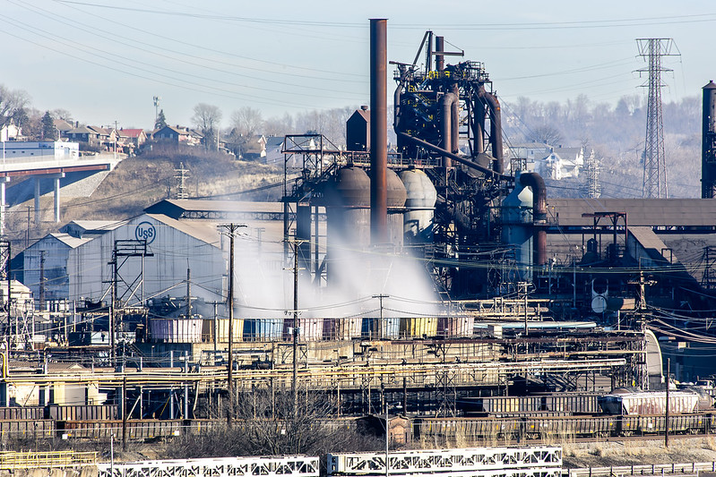
– photo by Mitch Waxman
The Mon Valley Works – Edgar Thomson Plant. That’s what the U.S. Steel outfit calls this steel mill, parts of which date back to 1875 and Andrew Carnegie. It’s where the United States’ first Bessemer Converter was installed, and is a cornerstone of our American story.
Having never witnessed this sort of thing in person before, the Mon Valley Works absolutely blows my mind. Wow. I’ve seen Battleships, and Air Craft Carriers, and mega massive sewer plants, and power generating stations, and petroleum refineries, and waste transfer stations, and port infrastructure – but I’ve never seen anything like this before. Blown.

– photo by Mitch Waxman
I had carried all the gear I use with me onto the Great Allegheny Passage trail, and got busy with the tripod and everything else as soon as a decent point of view of the Mon Valley Works appeared. Next time I visit the GAP, I’m planning on entering the trail from the Duquesne side to explore what you can see from that set of angles.
I’m also going to return to this position for early morning and late afternoon light when it warms up a bit, but I fear that spring and summer will create problems for me due to the vegetation being clad with leaves.
– photo by Mitch Waxman
Even across the Monongahela River, and pretty distant, the Mon Valley Works are loud. Massive fans are at work for the heat exchangers, and the furnaces also are beaming out vibration and sound. The plant is also pumping out a terrific amount of sulfur dioxide, as it runs off coke and coal, so there’s a smell of rotten eggs which is omnipresent in the air.
I’m told that air quality in the Pittsburgh area can be awful, largely because of these coal fired heavy industries. So much so that there’s a website which tracks the plumes of pollutants that the three big steel mills pump into the atmosphere. Prevailing wind and economic geography decide who gets to breathe the stuff in. These steel mills, however, form and produce the building blocks for other industrial sectors, and always have. Somebody always pays the price for “progress.” It’s something to remind yourself about as you consume new manufactured products in the manner of a raging wildfire.
– photo by Mitch Waxman
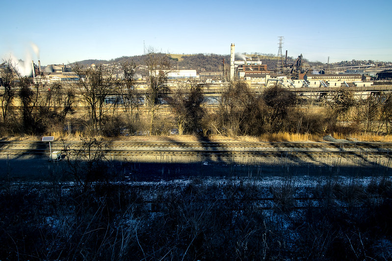
On the side of the Monongahela River that the GAP trail follows, you’re a pretty decent distance away from the shoreline. I did a wide shot to illustrate that, and to pass on the advice that if you want to get shots of the plant, bring a zoom lens with a not insignificant range.
As mentioned, those trees are going to block out the view during the warmer months. This was my turnaround point for this walk, as I’d have about another 4 miles to walk to get back to the Mobile Oppression Platform (my nickname for the car) which was parked at the Homestead Pump House. How did I come up with “Mobile Oppression Platform”? First, I owe a debt to the writers of the Futurama cartoon, secondly… have you ever talked to the bicycle people in Queens? Ever heard a car described as a two ton murder machine? I have, and took inspiration from the bellicose posturing they offered. If “two wheels good, four wheels bad” is your motto, I figured I’d give my car a name to piss you off. I’m a Dick like that.
– photo by Mitch Waxman
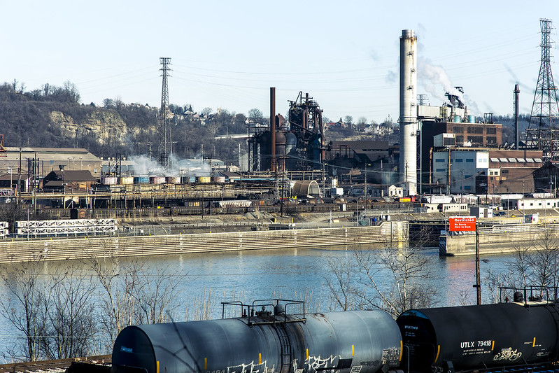
There’s so many things I want to get close up to in the shot above, including the Army Corps of Engineers lock and dam at the right side of the shot. After a disastrous flood in the 1930’s, the USACE installed a series of locks and dams on the rivers leading to Pittsburgh to control the waters. There are multiple USACE lock and dam facilities in the Pittsburgh area which I’m “kvelling” to get closer to.
I packed up my more esoteric gear after this one, reverted back to handheld shooting mode, and started retracing my steps back to the Mobile Oppression Platform in Homestead and my ride back to HQ.

– photo by Mitch Waxman
On my way, I cracked out a few more shots, and was passing by the defunct Carrie Furnace just as the light became a bit kinder. As mentioned in the first of these posts, it was fantastic to walk a fairly long distance again. It’s been a couple of months, what with the move and the setting up of housekeeping and all that, since I’ve had the chance to just scuttle about and see these sort of things.
Next week, something different at this – your Newtown Pentacle.
“follow” me on Twitter- @newtownpentacle
Buy a book!
“In the Shadows at Newtown Creek,” an 88 page softcover 8.5×11 magazine format photo book by Mitch Waxman, is now on sale at blurb.com for $30.


As a bicyclist who likes not getting run over but also owns two cars, I will not refer to your car as a murder machine 🙂
Thanks for the write up btw. Enjoying seeing the photos.
Simple Suburban Existence
January 27, 2023 at 1:43 pm
It’s eye catching that there are pink, blue and yellow painted objects in the midst of all that. Is that steam coming out of them?
Jaye Haviland
January 29, 2023 at 9:20 am
I believe so, and my understanding is that those are atmospheric heat exchangers. Saying that – grain of salt as I’m surmising and educated guessing.
Mitch Waxman
January 29, 2023 at 10:37 am
[…] When time and opportunity present, though, I get my butt moving! The plan for the rest of the afternoon involved scuttling down the Monongahela River shoreline towards the Station Square “T” light rail stop. This pathway leads into a connection with the Three Rivers Heritage Trail, which is another one of the many (fantastic) rail-to-trail pathways that snake around the city. A couple of weeks ago, the Great Allegheny Passage’s trail in Homestead was discussed – part 1, part 2, part 3. […]
Fort Pitt Bridge, part 2 | The Newtown Pentacle
February 8, 2023 at 11:45 am
[…] On the Hot Metal Bridge’s pedestrian path, which is completely separated from the vehicular lanes, and heading north – that’s where this shot was gathered. I didn’t have any particular goal for the afternoon other than kicking my feet about and getting some exercise, but I was able to piece together a mental map of where I was scuttling based around prior explorations – which I’ve described here – of the Monongahela Valley. Locally, it’s referred to as the Mon Valley by the politicians, but when they say that it’s usually in reference to the still quite industrial areas to the east like Clairton and Braddock. […]
Hot Metal, 3 Rivers Heritage Trail | The Newtown Pentacle
February 14, 2023 at 11:00 am
[…] while back, I offered several posts (Part one, Part Two, Part Three) from the section of the GAP stretching from Homestead to a point directly across the Monongahela […]
Second GAP: Part 1 | The Newtown Pentacle
March 6, 2023 at 11:15 am
[…] neighborhood of Swissvale. Found along the Monongahela River, Swissvale is neighbored by Rankin, Braddock, and is just across the river – Homestead and Duquesne. This is a fairly depressed area, in […]
Corduroy City | The Newtown Pentacle
February 27, 2025 at 11:00 am