Posts Tagged ‘Panhandle Trail’
Walkers Mill, Panhandle Trail
Thursday

– photo by Mitch Waxman
The start of the Panhandle Trail is pictured above, at a location which the people who run the institution call ‘Walkers Mill.’ Recent endeavor led to discovery of the trailhead location, which offers both parking and a porta potty. I checked the location into active memory after seeing it, and resolved to return and check the trail out. Glad I did, as Walkers Mill is only a 15 minutes drive from HQ. This sort of place is precisely what I’m needing at the moment, in terms of the post broken ankle ‘stretching and strengthening’ mission described in a post earlier this week.
This is a ‘rail trail,’ meaning that there used to be a freight train outfit whose ‘right of way’ was abandoned when they went out of business. I grabbed a shot of their signage, describing the history of this route, which you can see here. Obviously, a great more detail can be gleaned at the friends of the Panhandle Trail website.
I’ve encountered another section of the Panhandle Trail in the Pittsburgh metro area before, where it crosses the Montour Trail at a nice railroad trestle bridge. As it turns out, you can theoretically walk to West Virginia on this path. How’s about that? You’ll know you’re there when you start hearing Banjo music being played.

– photo by Mitch Waxman
Alongside the trail is a shallow but quick flowing waterway called Robinson Run. The trail had a few other people walking and jogging around, but the population was sparse (it was a Monday, early afternoon). Your humble narrator had a few errands to accomplish nearby, and a Doctor’s visit later in the afternoon with the orthopedist who put Humpty Dumpty back together again. There’s a side trail or two which take you into the woods, notably one which leads to a ‘fossil cliff.’ The signage cautioned that accessibility is ‘difficult,’ but that usually refers to the grade of the hill. At the moment, walking on steep grades is still an issue, so I filed away that one for a visit in a couple of months when the ankle is stronger and surer.
Robinson Run does seems to receive a good amount of waste water from the surrounding town’s residences and businesses, based on my observation of the liquid’s coloration in areas of the stream bed which allowed pooling, and a few good sniffs.

– photo by Mitch Waxman
This sort of thing is absolute nepenthe for me right now, especially so with the vague odor of sewage popping up every no and then. Reminds me of home. Speaking of, I’m going to be back ‘in the old neighborhood’ for a few days in June. My dance card is already fairly full, but I’m planning on riding the ferry, smelling salt water (mixed with sewage), and visiting a certain waterway which provides the border of Brooklyn and Queens. I used to add in ‘undefended border,’ but who knows what’s been happening there since I’ve been gone.
Crushed limestone or paved surfaces, the Panhandle Trail is graded according to railroad standards, one foot’s worth of change in elevation for every hundred linear feet horizontally. Easy walking, this, and given that the rest of this year is going to be all about getting my legs back into scuttling condition… perfect.
Back tomorrow with more.
“follow” me on Twitter- @newtownpentacle
Buy a book!
“In the Shadows at Newtown Creek,” an 88 page softcover 8.5×11 magazine format photo book by Mitch Waxman, is now on sale at blurb.com for $30.
Foyleeages
Friday
– photo by Mitch Waxman
I’m always entertained at the way that the colloquial phrase “Fall Foliage,” gets mangled by the proletariat in the manner of it being describable as a tongue twister. Our Lady’s recovery from a medical situation had finally progressed to the point that we decided it would OK to go out of doors to somewhere pleasant, bringing along Moe the Dog, to take a short walk together amongst the ‘foyleeajes.’ We thereby drove about a half hour north of HQ, to the intersection of the Panhandle and Montour trails in the McDonald section of Pittsburg.
This particular trail location was described in posts from back in May of this year – here, and here. Back then, the folyages were spring time green, and I had been on my own. Moe had probably just been born into the dog shelter and pet fostering system, which ultimately brought him to us. Personally, I’m pretty much the same icehole.
Moe the Dog seemingly enjoyed a very nice time. Moe got to mortally wound a vole, as part of his never ending quest to annihilate all mammals smaller than himself, then menaced another dog, and os now capable of pulling me forward – via the leash – at great rates of speed that I’m uncomfortable moving at. He’s also discovered ‘dog anchor mode,’ wherein he suddenly stops moving and solidly locks onto the planet. The vole thing happened during one of these sudden stops.

– photo by Mitch Waxman
It’s ‘leaf season’ hereabouts, when the autumnal ‘burning hills of Pennsylvania’ asserts itself. Lots of orange and yellow colors are painting the hills of Appalachia, and it’s not just a hundred shades of green for a change.
Really nice experience, this. Moe the Dog ate about four pounds of those autumn leaves, then accosted a passing stranger and forced the poor guy to accept his puppy love attack. The guy didn’t mind, and Moe – thankfully – didn’t bite him in the crotch. Our Lady was beaming, taking the sun, and esthetically enjoying the setting.
– photo by Mitch Waxman
I guess we were wandering about in this area for a couple of hours, but after an interval we had other places to go, and more prosaic things to accomplish. Our Lady enjoyed herself, after enduring a three week long hermitage. It was a good walk, with ideal climate. We stuffed Moe the Dog into the Mobile Oppression Platform for the ride back home. Moe fell asleep while standing in the back seat.
All was right in the world, at least for a few hours on an autumnal afternoon in Western Pennsylvania. This was the 7th of October, mind you, and it wasn’t until we got home that we saw the news from overseas about Israel. I think lots of things about that, but it’s not my wheel house and will be staying out of conversation about it, except to offer my actual reaction – ‘oh my god, all those ordinary people on all sides of this… who have been caught in the middle of all this hell… uggh.’
Back next week with something different – at this – your Newtown Pentacle.
“follow” me on Twitter- @newtownpentacle
Buy a book!
“In the Shadows at Newtown Creek,” an 88 page softcover 8.5×11 magazine format photo book by Mitch Waxman, is now on sale at blurb.com for $30.
Old McDonald
Tuesday

– photo by Mitch Waxman
Now that the weather has turned to Spring here in Western Pennsylvania, one has resumed his long scuttles. I’ve had a few fantastic walks in the downtown area where the three rivers convergence occurs, but as I’ve told anyone who will listen – the network of ‘rail to trails’ public spaces here in Pittsburgh are absolutely fantastic.
I drove the Mobile Oppression Platform (the Toyota) from HQ to a town about 30 minutes away from HQ called McDonald. I was heading for the convergence of two former railroad right of way’s which have been converted over to trails – the Panhandle and Montour.

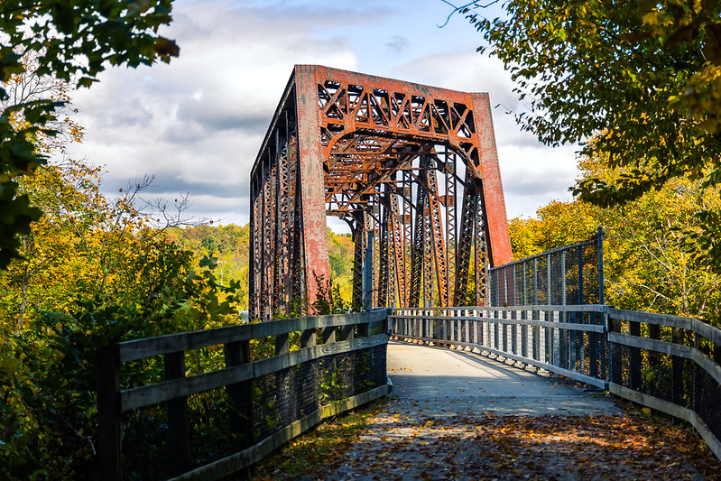
– photo by Mitch Waxman
Rail bridges are incorporated into this rail to trail network, which offers one such as myself the rare opportunity to gain some altitude in an otherwise wooded and somewhat natural environment. When I say ‘somewhat,’ it’s because this entire area is post industrial. This used to be “oil country” back in the early days of the petroleum industry, and the engineers who worked for the rail companies that served the various industries in Pittsburgh did things in an expeditious fashion ‘back in the day.’ If there was a hill or a mountain in the way of your tracks, you’d blow them up with dynamite and use the rubble to fill in the next valley. The term ‘terraforming’ kind of applies.
The McDonald oil field was one of the largest and steadiest producers of petroleum in the United States during the early days of the oil industry, and operated right up until the 1960’s. Supposedly, there’s still productive well heads nearby. The market for 19th and early 20th century crude oil were refineries in the big cities along the Atlantic Coast and the Great Lakes, and it was shipped by various rail entities until the pipeline shipping method became more common. When the pipelines came along, the rail people began to go bankrupt. One of the pipelines leading eastwards from here went to Queens in NYC, where it fed the Standard Oil (later Mobil) refineries along – you guessed it – that fabulous ribbon of neglect called the Newtown Creek.

– photo by Mitch Waxman
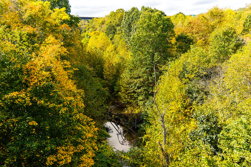
I had probably walked a couple of miles beyond the rail bridge on the trail, whereupon an enormous and quite modern truss bridge set upon concrete piers was encountered. Apparently, the Pennsylvania Turnpike runs on the road above, and it’s heading towards the airport here in Pittsburgh. I wasn’t alone at all on this walk. People were riding bikes and jogging, and there were all sorts of very happy looking dogs being walked on the trail as well. Hawks and other predatory birds were twisting around up in the sky looking for luncheon, and all sorts of mammalian critters were observed skittering about.
What made this walk really interesting will be discussed in tomorrow’s post, so be sure to come back to Newtown Pentacle if you want to find out ‘sup.
“follow” me on Twitter- @newtownpentacle
Buy a book!
“In the Shadows at Newtown Creek,” an 88 page softcover 8.5×11 magazine format photo book by Mitch Waxman, is now on sale at blurb.com for $30.


