Posts Tagged ‘Pennsylvania’
calculations would
Wednesday

– photo by Mitch Waxman
It’s about a mile’s walk, all uphill, along Pittsburgh’s Grandview Avenue, from the Monongahela Incline to the Duquesne Incline. Along the way, I was shooting, and the shutter was a-clicking.
The up hill walk gave me time to reflect on everything I was experiencing. It also reminded me that I grew up nearby “Flatlands Avenue” and not too far from a place called “Flatbush.” “Flat” is a recurring theme in NYC, after all. We all live on a flood plain, whereas Greater Pittsburgh is definitively “not flat.”

– photo by Mitch Waxman
As mentioned in earlier posts, Mt. Washington used to be called “Coal Hill” and by early 19th century standards the mineral deposits found here were considered to be one of the most valuable resources in Western Pennsylvania. Coal Hill was rechristened as Mt. Washington in 1876. From my limited observations, it seemed like a pretty nice choice as far as places to live.
Once again, the topology of Pittsburgh boggles the mind, especially for someone who grew up in a place defined by terms like “sea level” and the omnipresent usage of the descriptor “flat.”

– photo by Mitch Waxman
Vehicular roads leading to and from Mt. Washington use sharp turned switchbacks to allow cars and trucks egress to the area. The ridge directly overlooking the downtown area had several multi unit homes arranged along it, but there were also plenty of places for visiting lookie-loo’s like me to check the scene out from.
For a sense of the elevation, the UPMC building at the left of the shot is the tallest building in the city.

– photo by Mitch Waxman
Here’s a look at one of the neighborhoods up on Mt. Washington, where that weird topology is manifestly visible. I have a friend who’s got a brother that lives in the Pittsburgh area, and said brother is a photographer. The Brother – who is dubbed Tim Fabian – provided photos for a book by author Bob Regan on “The Steps of Pittsburgh.” It seems that all of these neighborhoods – up and down the hills – are vertically connected by 712 public stairways. Again – fascinating.
The housing stock of Pittsburgh, if I might comment, is disturbingly heterogenous. You see all sorts of floor plans and massing shapes here.

– photo by Mitch Waxman
As mentioned the other day, day two in the Steel City bore the threat of possible rain, but I didn’t find myself inconvenienced by precipitation. The volatile weather of Pittsburgh was on display, however, as just a couple of miles away it was raining – as you can discern in the shot above. Weird, huh?
It really was quite a walk between the two inclines. If you find yourself here and on foot, I’d suggest reversing the order I chose – Duquesne Incline first and Monongahela Incline second. If you hit the higher one first, it’s all downhill from there.

– photo by Mitch Waxman
My “good photo luck” game was strong on Day 2 in Pittsburgh, and I spotted a push boat towing an equipment barge under the Fort Pitt Bridge. Wasn’t the last lucky capture of the day for me, not by a long shot.
Tomorrow – the Duquesne Incline!
“follow” me on Twitter- @newtownpentacle
Buy a book!
“In the Shadows at Newtown Creek,” an 88 page softcover 8.5×11 magazine format photo book by Mitch Waxman, is now on sale at blurb.com for $30.
without dissolution
Tuesday

– photo by Mitch Waxman
In the middle 19th century, enormous numbers of German speaking people began to migrate to Pittsburgh to take advantage of the limitless employment opportunities in the burgeoning iron and steel industries. One of them was a Prussian engineer named John Endres, who actually lived in Cincinnati. Endres designed and oversaw the construction of the 1870 vintage Monongahela Incline. This funicular railway is the oldest continuously operating funicular in the United States.
There used to be 17 incline or funicular railways in Pittsburgh, several of which were used exclusively for freight rather than passenger service. The inclines allowed workers to move into the steep hills and valleys surrounding the so called “Golden Triangle” river delta.

– photo by Mitch Waxman
Operated in modernity by the Port Authority of Allegheny County (whose Monongahela Incline staff were incredibly nice, helpful, and friendly, btw), this attractive structure is the station house at the top of Mt. Washington on Grandview Avenue. The overlook which I shot yesterday’s post from is just alongside it on the uphill side. You walk in the building (masked up since it’s considered mass transit), and are free to observe several framed historic photos and newspaper clippings. There’s a gift shop, and a ticketing machine. A round trip ticket cost me $3.50.
Before boarding, I changed lenses, and attached the foam collar I’ve mentioned a few times to the thing. The foam collar allows me to place the lens against windows without annoying reflections manifesting in the photos, as well as forming a flexible prophylactic that keeps the lens from interacting mechanically with the window glass – in terms of transmitted vibration.

– photo by Mitch Waxman
Looking out of the window of the Monongahela Incline at the lower station house, which I’m told was rebuilt in 1904. The way that these haul rope cable railways work is that as one car is descending, the other one ascends. How amazingly simple, and how super complicated, this system is, huh?
I had a single fellow passenger in the car with me and we briefly chatted about her City on our journey down to the lower station. She was retired, and extolled the virtues of Pittsburgh to me from that point of view. It seems that the City is currently tied with Miami for the number of retirees living in the area, due to its fairly low cost of living. The City encourages mass transit use by this population by making transit free to people over 65.
Entirely different from back home in NYC where “go fuck yourself asshole, ride a bike” or “you’re a racist” is the answer to most things transit related, and where our familiar MTA public transit agency is a dumpster fire of a political patronage mill whose managerial payroll is populated by the not too smart nephews and nieces of god awful upstate politicians, ones who haven’t yet been sent to jail for financial corruption or sex crimes. Heh, look at that, I actually suggested that the political class in New York can be convicted for the crimes they commit in office. Hah.

– photo by Mitch Waxman
The incline car carried us to the lower station house, where my new acquaintance expected to meet a bus – which would travel in its own dedicated lane – that would in turn take her to a supermarket. She planned on making the return trip, with bags of groceries, using the bus and incline. Imagine being able to use a predictable form of mass transit, with buses that run on schedules that are more or less accurate.
I’m just so sick of all the dystopian shithole crap in NYC these days, you have to forgive me. I just cannot reconcile the amount of tax money that our politicians allocate to transit with the level of services delivered. There are no consequences for bad behavior either. Get caught with your hand in the cookie jar, or stroking the cookie jar suggestively, you just get railed by the headline writers and then disappear for a few months and run for another office. Single party rule sucks, it breeds corruption, and it’s result is… well, just look around your neighborhood.

– photo by Mitch Waxman
At the lower station of the Monongahela Incline, nearby a fairly tragic series of land use decisions called “Station Square.” This area too will be explored in some detail in later posts from my 72 hours in Pittsburgh. As a note, several of the locals complained about heavy traffic to me as being a detriment to life in this city. Maybe I’m jaded by NYC’s omnipresent traffic jams, clustered around the river crossings, but “by me” everywhere I looked – even at rush hour – it was smooth sailing.
After getting a few shots down here at the foot of Mt. Washington, I used my round trip ticket and headed back up to the top.

– photo by Mitch Waxman
Gosh, do I love me a good funicular.
There’s one funicular in Chile’s City of Valparaiso that I aspire to ride on someday, but that’s going to take a lot more than an Amtrak ticket and 72 hours to accomplish. I’m also going to have to develop a functional ability to speak Spanish to chat with the locals for that one.
More tomorrow – at this – your Newtown Pentacle.
Also, if you enjoyed this post, or Newtown Pentacle in general – would it be too much to ask for you to share it out to your social media feeds? Maybe just hit “like” or leave a comment?
“follow” me on Twitter- @newtownpentacle
Buy a book!
“In the Shadows at Newtown Creek,” an 88 page softcover 8.5×11 magazine format photo book by Mitch Waxman, is now on sale at blurb.com for $30.
needed formula
Monday

– photo by Mitch Waxman
Before another word gets mentioned, a humble narrator must confess that he is an absolutely goof for funicular railways. A cable car arrangement, which uses haul ropes and a system of sheaves to exchange the positions of the two cable cars from top to bottom, this is a pretty early example of “people movers.” I got to ride on one or two of these in Europe a few years back, and so was one of my nerd obsessions born. Pittsburgh has two working funiculars, but they call them “inclines” there. Both are found on Mt. Washington and are operated and maintained by the Port Authority of Allegheny County. The Monongahela Incline, pictured above, is the oldest operating funicular in the United States, having operated continuously since 1870, and later in the week you’ll come for a ride on it (and the other one too) with me.
Amazingly, one of the features of these “inclines” is the presence of a large terrace or “overlook” platform open to the public, to take in and appreciate the views from high up on the prominence of Mt. Washington. Before I got busy with “nerding out,” the camera and tripod were deployed and I got busy.

– photo by Mitch Waxman
Pittsburgh is famously sited at the conjunction of three rivers – Ohio, Allegheny, and Monongahela. The latter is on the south side of the city and pictured above. This was day two of the Pittsburgh leg of my September travels on Amtrak, and all in all I was in the city for about 72 hours. A late afternoon boat tour ticket was in my pocket, but for now I was in the cat seat high above the Golden Triangle of Downtown.
I kept on thinking to myself that about a hundred years ago you wouldn’t be able to even see the city for all of the smoke stacks belching coal smoke into the air. Steel mills, power plants, railroads – that’s what Pittsburgh used to be before the deindustrialization of the 1960’s and corporate reorganizations of the 1970’s and 80’s which reduced Pittsburgh’s population by half and annihilated its tax base.

– photo by Mitch Waxman
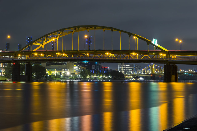
The bridge at the center bottom of the shot above is small but spectacular, and as I learned later in the day, kind of special and noteworthy from a Civil Engineering point of view. Especially so if you happen to live in NYC’s Queens. More on that in a later post.
It was about 65 degrees, overcast, and the forecast called for passing showers. I never got rained on, but from up here on Mt Washington, you could see that it was raining just a few miles away in different sections. Again, the weird topology of Pittsburgh and its riverine continental climate just fascinated me.

– photo by Mitch Waxman
Pictured is a pretty major bridge for the City, the Fort Pitt bridge, which connects to the Fort Pitt Tunnel which carries southbound traffic out of Downtown and towards their airport and suburbs. Behind it is Point Park, with its fountain, and the convergent intersection of the three rivers. Again – more on all that in future posts.
This city has 446 bridges, and I could spend months talking about the “who, why, where, and significance of” each one.

– photo by Mitch Waxman
On the south side of the Monongahela River, the bridges cross over still quite active freight tracks. The bridge closest to the camera is a rail bridge, whereas the other three are vehicular crossings.
We’ll talk about – again – the granular details about them when the posts from the boat tour reach you in the near future. At this stage of the morning, a humble narrator was deep in photo mode.

– photo by Mitch Waxman
What a spectacular place this is. I’ve been to Pittsburgh before, but that was back in the early 1990’s when I was in town hawking a comic I had drawn which was just published. One used to spend his weekend’s traveling from place to place, usually by car, doing “shows.” Shows were Comic Conventions. You’ve got your “big shows” like San Diego Comicon, or the New York and Atlanta ones, but there’s a comic convention happening in a hotel ballroom in some analogue of Wayne, New Jersey each and every weekend in the United States. For the Pittsburgh one I attended – during the Presidential administration of George Bush Senior – I was actually the featured guest and the promoter flew me out and paid for my hotel room. A friend from college is from Pittsburgh and she gave me the nickel tour when I was here, but even at that time I had made a mental note to return here someday and explore.
More tomorrow.
“follow” me on Twitter- @newtownpentacle
Buy a book!
“In the Shadows at Newtown Creek,” an 88 page softcover 8.5×11 magazine format photo book by Mitch Waxman, is now on sale at blurb.com for $30.
terrestrial gravity
Friday

– photo by Mitch Waxman
Day two in Pittsburgh began before the sun came up, and I was showered/dressed/ and charging the camera batteries up for another bridges heavy shot list. The day’s weather forecast was perfect for me – middle 60’s, breezy, and a bit overcast but no rain.
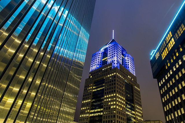
At the center of that shot above is the tallest building in Pittsburgh. It’s the 58th tallest building in the United States, and used to be known as the USX tower. Today, it’s the called the U.S. Steel building, and it’s the HQ for that company as well as UPMC – the University of Pittsburgh Medical Center – whose illuminated logo adorns the summit.

– photo by Mitch Waxman
Funnily enough, the shot above was total serendipity. I was throwing out a bit of garbage I had generated over the last two nights in the AirBNB at the Clark Building, and this is the view from the garbage room, which looks towards the Alcoa building on the Allegheny River’s north shore and the 10th and 9th street (Andy Warhol and Rachel Carson) bridges. I walked out onto Liberty Avenue at about 7 in the morning.
First thing on my list was breakfast, and since throughout these travels the heavy pancake/bacon/egg deal had served me well, I was looking for a diner or coffee shop to purchase a meal of that type. A bit of quick googling revealed a spot just a few blocks away, but it didn’t open until 8 a.m. so I had a little time to kill. After a cup of steaming black coffee was obtained at a convenience store, I was on my way.

– photo by Mitch Waxman
Pittsburgh seems to have a lot of alleys. They also haven’t turned all of their downtown parking lots into condominiums with the proviso that you should ride a bike or you’re an asshole, or intone that you hate minorities if you oppose more luxury housing, the way they do in NYC. It’s almost like Pittsburgh has other industries whose opinion matters, beyond the one offered by big real estate, when the Electeds are making decisions here.
Naturally attracted to shunned places, I had to walk through a few of them. I spotted this hilarious sign in one of those alleys.

– photo by Mitch Waxman
While “photowalking” to breakfast, I spotted lots of intriguing and fairly old municipal buildings like the Firehouse pictured above. I also observed that the infamous Midwestern “Opioid Epidemic” has taken over a lot of lives hereabouts. Drug and addiction treatment centers abounded, and I saw hundreds of people waiting on line for their little plastic cups of orange liquid (methadone) who all wore the tell tale mask of heroin use on their faces. That sucks. I don’t wish that life on anyone, even if they did it to themselves. Heroin breaks people into little evil pieces, and turns them into shadows. You can call it OxyContin if you like, but it’s heroin. This drug epidemic is the actual consequence of going to war in Afghanistan, by the way.
Poor bastards.

– photo by Mitch Waxman
An old downtown department store was receiving a lot of attention from construction crews when I passed by, and luckily this amazing public timepiece wasn’t being demolished by them. Just look at that thing. Jeez. Talk about gilded age, huh.
Most of the historic building stock encountered was reminiscent of the early 20th century examples you encounter in Manhattan’s financial district. Ornate Neo classical facades, street level grand entrances, lots of massive stone structure punctuated with enormous plate glass windows. Cathedrals of Capitalism. Unlike NYC, setbacks for upper floors didn’t seem to be a thing here, and you have all of these dark and shadowed alleys between and behind which expose the “works” of the buildings – the HVAC piping, electrical hookups, and so on.

– photo by Mitch Waxman
After breakfast, I summoned a LYFT ride share to carry me to my first destination of the day on the south side of Pittsburgh on Mount Washington. Formerly called Coal Hill, the prominence was dubbed Mt. Washington in 1876. It hosts the two inclines – or Funicular Railways – and is on the south side of the Monongahela River. Mt. Washington offers an elevated point of view from which any visiting photographer is obliged to actuate the shutter. Ultimately, most of my second day in Pittsburgh was spent in close association with Mt. Washington and the Monongahela River. The boat tour I had purchased advance tickets for would leave its dock from this side of the city later in the day.
More next week – at this – your Newtown Pentacle.
“follow” me on Twitter- @newtownpentacle
Buy a book!
“In the Shadows at Newtown Creek,” an 88 page softcover 8.5×11 magazine format photo book by Mitch Waxman, is now on sale at blurb.com for $30.
certain circumstances
Thursday

– photo by Mitch Waxman
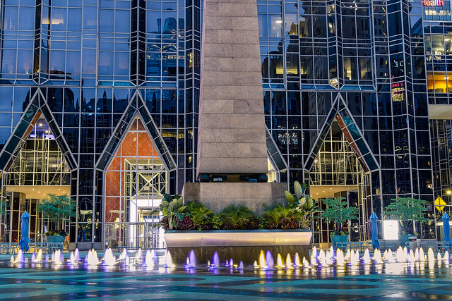
After eating dinner at one of Pittsburgh’s iconic Primanti Brothers restaurants, one got busy on his evening plans. The camera was rigged up for low light/night shooting, and a humble narrator got to work. Pictured above and below are sections of PPG Place, a 1984 vintage six building commercial real estate complex built and primarily occupied by the Pittsburgh Plate Glass outfit. The main 40 story building, whose ground floor entrances sit behind that fountain, is the corporate headquarter for PPG. The entire deal is clothed in plate glass, some 19,750 panels (over one million square feet of glass) of it, which is why it looks like an early 1990’s CGI background. Wet glass, LED lighting, weird look and feel. PPG has operated out of Pittsburgh since 1895.
The PPG complex sits on six square blocks or one square acre, replaced a department store called Guskey’s, and it’s construction revealed a cornucopia of archaeological finds ranging from Native American to early Colonial and pre industrial uses of the site. The main tower is the third tallest building in Pittsburgh.
– photo by Mitch Waxman
As mentioned several times in the last few weeks, on this particular interval of travel, one felt compelled to record the scene whenever and wherever a fountain was discovered. This wasn’t much of a fountain, in comparison to what I saw in Washington D.C., but there you are. Apparently, during the holiday season and winter months, this plaza is converted over to be an ice skating rink. It’s a fave for Pittsburghers, apparently, with high occupancy rates and several newspaper polls listing it as the voted on choice for “best building” in the City.
– photo by Mitch Waxman
The fourth tallest building in the City of Pittsburgh is nearby, which is called “Fifth Avenue Place” officially, but is colloquially called Highmark Place. 31 floors, and completed in 1988, it’s the HQ for a Highmark subsidiary called Jenkins Empire Associates. Highmark is a non profit health insurance organization which also owns several for profit medical insurance and reinsurance companies. Basically – Highmark is the corporate entity that Pennsylvania and West Virginia’s Blue Cross and Blue Shield have reorganized themselves into.
The building was originally meant to be a bit taller, but city zoning officials squashed that. The 13 story tall spire atop the building was an attempt to lay claim to the original height that the architect planned for, and with all the hub bub over the zoning deal it was never transmitted to the City that the spire/mast was designed to sway up to three feet when high winds hit the top. It seems that the first time this sway was observed, Pittsburgh’s First Responders shut the downtown area down fearing that something catastrophic was about to occur.
– photo by Mitch Waxman
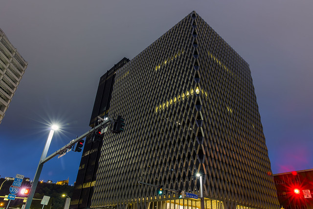
Developed by the Equitable Life Assurance Society, in 1964, this “caught my eye” structure – with its fascinating load bearing external diagrid and framed tube steel exoskeleton – was built on the footprint of an old Wabash Terminal Train Shed. When it opened as the IBM Building, its principal tenants were the IBM corporation on floors 1-4 and U.S. Steel on floors 5-13. It was bought by the United Steelworkers Union in 1973, and the labor organization’s offices are still housed therein.
A bit of skyscraper trivia is offered here. The same people who designed the external structure of the building also did the World Trade Center in NYC. Just like the WTC, the structure of the building is outside the walls, and within the only structural supports are at the center of the thing surrounding the elevator and plumbing/electrical cores. Neat!
– photo by Mitch Waxman
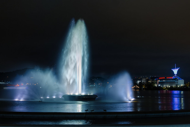
My next stop was yet another fountain, this time being Pittsburgh’s “big kahuna” at Point State Park. It’s found at the “tip of the spear” on the river delta formed by the three rivers – Ohio, Allegheny, Monongahela. 36 acres in size, this Pennsylvania State Park was opened in 1974. Its fountain is the iconic center of the larger metropolitan region, and Pittsburgh’s reclamation of its post industrial waterfront really started with the opening of this park. The fountain sits where the on and off ramp of two bridges used to be found, the Manchester and Point Bridges.
The park incorporates the remains of Fort Pitt and Fort Duquesne, which were important fortresses during the French and Indian War (1755-1764) and although I’m largely ignorant about the details of the conflict here at the ‘forks of the Ohio,” there’s a nearby spot referred to as “Washington’s landing” so… George Washington.
– photo by Mitch Waxman
The one Allegheny River Bridge between Point Park and the 31st street Bridge I didn’t show you yet is pictured above, the so called “Bridge to Nowhere” or Fort Duquesne Bridge. It carries Interstate 279 (North Shore Expressway) and Interstate 376 into and out of Downtown Pittsburgh and also has a pedestrian walkway in the lower deck. It’s got a steel bowstring type span of 426 feet, and provides a water clearance of 46 feet. It opened to traffic in October of 1969.
Whew. All of this Pittsburgh stuff that you’ve seen here at Newtown Pentacle for the last two weeks was literally captured in one day between 7 a.m. and about midnight. It started raining again while I was capturing the bridge shot above, so I double timed it back to the street and caught a cab back to the AirBNB. Starting tomorrow – Day two. I was just getting started on day one, and had to contend with the weather, and I also had tickets for a boat tour of the rivers nested in my pocket for day two. The things I saw…
If you haven’t yet subscribed to Newtown Pentacle, please consider doing so using the “sign me up” button and field at the top right.
Also, I’d greatly appreciate it if any of you could share these posts out to your social media accounts if you like them. I’m about to start doing tours of Newtown Creek again, I think, and would like to increase the “reach” and readership of this continuing effort.
“follow” me on Twitter- @newtownpentacle
Buy a book!
“In the Shadows at Newtown Creek,” an 88 page softcover 8.5×11 magazine format photo book by Mitch Waxman, is now on sale at blurb.com for $30.


