Posts Tagged ‘Pittsburgh’
Dormont noticings
Wednesday

– photo by Mitch Waxman
The Mobile Oppression Platform, as I’ve named the Toyota, was purchased and registered in New York State before we left. One last payout in tax to Albany, for me. State law here in the Commonwealth of Pennsylvania demands that resident vehicles be registered under their bureaucracies, and transferring the legal status of the vehicle – even between neighboring states – has proven to be surprisingly complicated due to having to handle the bureaucratic demands of two States and a large automobile manufacturer’s financing department. The long procedure was finally completed, and as the car is now wearing a Pennsylvania license plate, one had to bring the thing to a dealership for an inspection to scry its emissions and mechanical soundness. It’s a brand new car, so it obviously passed, but I still had to kill an hour or two. Luckily, just such a dealership is proverbially “around the corner.”
I did what I do when I’ve got time to kill, and walked around the periphery of the town I’m living in, called Dormont. There’s no such thing as a typical house here, according to my admittedly limited observations, but those homes pictured above are pretty typical and are likely in the 190-300k range. Unfortunately, they’re located along an arterial roadway and up the block from one of the worst McDonalds I’ve ever set foot in. I do like a McCoffee though, which is surprisingly decent as far as hot bean juice goes. Saying that – how do you screw up McDonalds? I used to work at a Burger King in high school, and I can tell you that it’s assembly line back in the kitchen. The only time you really have to pay attention is when your building the actual sandwich, everything else is timed and fairly automated.

– photo by Mitch Waxman
I drive past these buildings just about every day on the tertiary arterial road which connects the two secondary arterial roads that define the larger neighborhood. The blonde brick one has the word “Hafer” in block type across its lintel, and an intriguing design element which I think I’ve seen before. I’ve found an old ad from 1971, hawking Carrier Air Conditioners, that lists “Hafer’s” in Dormont at this address as a store where you can buy one of their units. I’ve also found an announcement from 1919 that a C.A. Hafer had been awarded a valuable plumbing contract on a then new housing development. Hafer seems to be a fairly common name in Pennsylvania, incidentally, so there’s a lot of false positives. Curious.
At least I now have a leading question to ask when I pay a visit to the Dormont Historical Society. I recognize this sort of design as a mercantile building, and that three circled icon… it’s a tip of my tongue thing, one which I know I’ve seen before. Masons, Shriners, Odd Fellows? Something.

– photo by Mitch Waxman
There’s a chain of casual dining restaurants, of the sort which were called “diners” once, in the Pittsburgh area called “Eat’N Park.” It’s one of those not terribly healthy for you kind of menus – pancakes with bacon and eggs, or burgers and fries, or corn dogs, milkshakes and pies – but sometimes that’s what you want on a weekend morning. This outfit is pretty consistent from location to location with their branding, service, and food quality even though they’re found all over the geography in these parts. I’m told it’s a family owned company that’s getting ready for a growth spurt of new locations, and they’re observationally pretty popular.
Luckily for me, these dudes were fixing an illuminated Eat’N Park sign here in Dormont, just as I got stuck at a red light.
Back tomorrow with something different.
“follow” me on Twitter- @newtownpentacle
Buy a book!
“In the Shadows at Newtown Creek,” an 88 page softcover 8.5×11 magazine format photo book by Mitch Waxman, is now on sale at blurb.com for $30.
Oliver Miller Homestead
Tuesday
– photo by Mitch Waxman
I swear that I had no idea about this, when I parked the car. An errand had found me in the neighborhood of South Park, in Pittsburgh’s South Hills, nearby the neighborhood of Bethel Park. The spot I had chosen to park nearby is a water and fountain feature called “The Cascades,” which as it turns out hasn’t opened for the warm seasons yet. After meeting a family of Deer, I took a short walk and found myself at the Oliver Miller Homestead public museum, where American Citizens first took up arms against George Washington and the newly created United States in 1794.
This is, I’m told, where the first shots fired of the Whiskey Rebellion were let loose. For those of you who didn’t pay attention in high school history class, or fell asleep during the endlessly boring lessons about the Articles of Confederation in 10th Grade, allow me to summarize our country’s very first tax revolt in a somewhat modern vernacular.

– photo by Mitch Waxman
Back in the day, the fledgling United States was drowning in debts which the Rebellion had incurred in pursuit of chasing the British Crown away. President Washington signed into law a tax on distillates like Rum and Whiskey. Agriculture enthusiasts had long been in the habit of distilling excess or surplus grains like rye, barley, wheat, and even corn into liquors. This is an old European trick, preserving summertime calories in a manner which could also coax the party spirit out of people. Also, in the days prior to the Germ Theory of Disease, your best bet to sterilize the water you were about to drink was to add a bit of the good stuff to it. They didn’t know that’s what they were doing, of course, but it was. Clean drinking water is one of the technologies seldom pointed to as creating the modern era, but there you are. This practice of adding a shot’s worth of an alcohol drink into your water is why rum or whiskey were a part of soldier’s rations right up to the 20th century.
To pay down the National Debt of $54 million, (current worth of that number would be $1,476,850,909.09 today) Washington and the list of famous names he worked with in Congress enacted the Whiskey Tax. To say that this went down like a lead balloon with the Frontier types (Lewis and Clark left for their journey to the west from Pittsburgh, literally the last outpost of European Civilization in those days, until you got to the Spanish holdings) in Western Pennsylvania and the Ohio Valley is a bit of an understatement. Many of these “Frontiersmen” had actually served under Washington during the rebellion.

– photo by Mitch Waxman
There’s a great account of the conflict which led to the Whiskey Rebellion becoming a shooting war in this post at Mt. Lebanon Magazine. Suffice to say that a tax collector came here to the Miller Homestead on July 15 in 1794. That drew a crowd, which soon became an incensed mob, and the Tax collector and Sheriff had to run for their lives. By the time that the Tax collector – one John Neville – was able to summon army troops to help him enforce the law, that angry mob had transformed into a Rebel Militia. Things went pretty much as you’d expect at that point, with trained soldiers on each side shooting at each other and farm buildings burning down.
Things soon progressed to the point that George Washington, President of the United States, assembled an army of 12,000 soldiers and was personally leading them – as a General – towards Pennsylvania. You can read all about it here, but you should have paid more attention to it back in 10th grade.

– photo by Mitch Waxman
Thomas Jefferson repealed the Whiskey tax in 1802 when he became President, and he blamed all the bloodshed and trouble in the region on his rival Alexander Hamilton, who had pushed Washington and Congress into accepting fiscal reality regarding the debts.
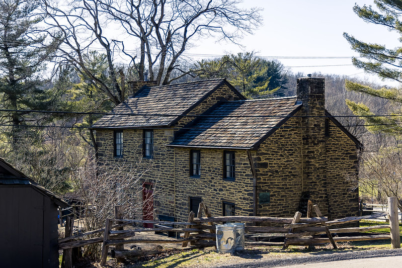
The Miller property was colonized in 1772, and the original deal here was a log cabin on a farm with several “out” buildings – a barn for the animals, a house for the slaves, etc. The log cabin was replaced in 1830, and the modern homestead building is called a “Stone Manse.” This is a protected historic place, and when the surrounding South Park was opened in 1931, the Miller Homestead was turned into a public museum.

– photo by Mitch Waxman
I observed several other small structures, including the cabin above and a “spring house” which hosted a large basin and fresh water bubbling up into it from below. The site was closed when I visited, but a humble narrator crossed the boundary while trying to save a butterfly from a predatory bird. That’s my story, sticking with it.
This was all just lucky serendipity for me, incidentally. As mentioned, I had no idea this was here, and somehow I made a beeline for it.

– photo by Mitch Waxman
South Park is pretty amazing, actually. There’s an animal preserve section nearby this spot which has Bisons living on it. Pictured above is a barn, which struck my fancy enough to take a picture.
Back tomorrow.
“follow” me on Twitter- @newtownpentacle
Buy a book!
“In the Shadows at Newtown Creek,” an 88 page softcover 8.5×11 magazine format photo book by Mitch Waxman, is now on sale at blurb.com for $30.
Nothing but blue skies
Monday

– photo by Mitch Waxman
That’s the Homestead Grays Bridge pictured above, spanning the Monongahela River. I don’t have much to say about it other it was lit up all pretty like on a recent Sunday afternoon when I was passing through. The last week has been pretty much overcast or super rainy here in Pittsburgh. Annoyingly so.
At any rate, one managed to get out and about a few times last week when it wasn’t raining or dire.

– photo by Mitch Waxman
An errand of a somewhat pedantic nature, actually a series of such errands, found me nearby something I’ve been wanting to take a gander at – Pittsburgh’s South Park. It’s another one of the mega massive public amenities hereabouts. I was in the neighborhood and had an hour or so to spare before needing to head back to HQ, so I picked out a random destination within the 2,000 square acre urban park to aim myself at.
When I pulled the Mobile Oppression Platform into a parking lot, a big pile of deer were roaming about. They stuck around for a few minutes and posed for pictures before scampering off into a wooded section.

– photo by Mitch Waxman
There’s an actual traffic roundabout in the park, something very common in Europe but not so much in the USA. As it turns out, the random spot I chose to pull the car over has an enormous “historicity” to it, but I’ve always been lucky when it comes to stumbling across places with an interesting past.
More on all that tomorrow, at your Newtown Pentacle.
“follow” me on Twitter- @newtownpentacle
Buy a book!
“In the Shadows at Newtown Creek,” an 88 page softcover 8.5×11 magazine format photo book by Mitch Waxman, is now on sale at blurb.com for $30.
another archive one today
Friday

– photo by Mitch Waxman
Captured the one above back in December, right about the time we moved from NYC to Pittsburgh. This is just east of the Strip District, where a few old mills and railroad warehouses have been converted over to theatrical production. There’s a movie and tv production industry here in Pittsburgh, and operations seem to be centered around this area. I was lucky enough to be driving through at sunset.
Back next week.
“follow” me on Twitter- @newtownpentacle
Buy a book!
“In the Shadows at Newtown Creek,” an 88 page softcover 8.5×11 magazine format photo book by Mitch Waxman, is now on sale at blurb.com for $30.
Damn, that’s one heck of a Dam
Wednesday

– photo by Mitch Waxman
The United States Army Corps of Engineers’ Montgomery Locks and Dam is one of the giant honking pieces of infrastructure an inquisitive wanderer might encounter in Pennsylvania’s Beaver County, while scuttling along the Ohio River. This isn’t too far from the currently undefended border of the states of Ohio and Pennsylvania, where the now infamous East Palestine locomotive derailment occurred. Up the Ohio towards Pittsburgh, you’ve got the Shell Cracker Plant mentioned on Monday and just down the river, there’s a nuclear power plant.
USACE has a page at their site which describes their operations on the Ohio in this region, which can be accessed here. To summarize – this monster dam and gate system was built between 1932 and 1936, and it replaced three earlier (late 19th century) wooden locks and dams.

– photo by Mitch Waxman
The mechanics of what this facility does involves mechanical lift gates and spillways which regulate the amount of river flowing through them. This outfit works in concert with other lock and dam installations to allow the Corps to maintain the “Pittsburgh Pool” and other navigational areas, but it isn’t intended to control the flooding issues which had previously bedeviled the region. A lot of Federal cash went into not having anything like the disastrous St. Patrick’s Day flood of 1936 happen again, but there’s a completely different set of infrastructure prophylactics in place for that sort of work. This is one of the many things that I’m reading up on at the moment.
See? I’ve learned, and am learning, new things since moving here.

– photo by Mitch Waxman
On the opposite shore, USACE has two lock systems, one for large ships and commercial vessels and another for smaller private or pleasure craft ones. The commercial lock is 600 feet long by 110 wide, and the secondary is 360 feet long by 56 feet wide. It’s costs about $6 million a year to keep this machine running, or so I’m informed.
The Ohio River is just under 1,000 miles long. It starts in Pittsburgh and eventually intersects with the Mississippi River at the southern tip of the State of Illinois. A river of cities, industry, and commerce – and a de facto extension of the Mason Dixon line between north and south – the westward flowing Ohio is also considered to be the most polluted waterway in the United States over the course of its length. It actually edges out Newtown Creek on pollution, but unlike my beloved creek, the Ohio is a source of drinking water for many of the communities found on its banks – parts of Pittsburgh, or West Virginia’s Wheeling for instance. The Ohio is thought to be the sixth oldest river in North America, and several civilizations have depended upon the ancestral waterway for its riches, including our own.

– photo by Mitch Waxman
Having followed the aforementioned group of fishermen whom I had noticed leaving a pickup for a trail towards the water, one soon found himself staring into the lift gates and spillways at the heart of the operation. I had prepared for my afternoon with a “full pack” camera bag and I had all of my toys and tools with me. These are all tripod shots with the lens wearing a 10 stop ND filter to slow down the scene and mellow out the visual distraction of water ripples and that sort of thing. Generally speaking, it was pretty bright out and these are 8-10 second captures.
When I’ve got a few extra bucks in my pocket, somewhere down the line, I’m planning on replacing my current set of old school screw on filters with the more modern magnetic snap on kind. So much easier to deal with, the magnet ones. You screw the receiver onto the lens and then just “click” the filter onto it. The screw on kind are dust collectors extraordinaire, are quite “fiddly,” and it is very, very easy to scratch your expensive lens with the exposed metal edge of the screw fitting on the thing. Yeah, I know, camera nerd stuff… sorry.

– photo by Mitch Waxman
The weather was definitely on my side for once, with temperatures in the low 50’s and a bright sky. It’s been a pretty warm winter here, but that’s also seen a lot of super cloudy days with dismal lighting. Back in NYC, this sort of atmospheric season would see me riding a lot of Subways out to distant stations and “shooting trains.” The subway system presents a series of horrific challenges, photography wise. Mastering that environment, which you’ll soon learn the rules of, is a fantastic exercise for learning how to work a camera.
One of the other things I’ve learned here in Pittsburgh is that when the skies are good, you take advantage of that. Pittsburgh is one of the cloudiest regions in the entire country, with something like 200 days of the year (on average) being cloudy or overcast. This is apparently caused by the shape of the terrain, which causes most storms to fly around or over Pittsburgh. Other surrounding communities less than an hour’s drive away will get walloped by snow or thunderstorms whereas in Pittsburgh itself you just get clouds and drizzle. Not a meteorologist, can’t tell you why, but it has something to do with being located in what’s considered “the foothills of the Appalachian Range.”
Where I was standing had signage indicating that this was a park, and in tune with that the thing that’s surprised this transplanted New Yorker just about everywhere I’ve visited – there was a Porta Potty available to the public to take care of business if the need arose. To a former New Yorker, this is acknowledgment of human biology is nepenthe.

– photo by Mitch Waxman
A humble narrator enjoyed a short chat with a young fellow working as a contractor for the Feds doing maintenance on the dam and its spillways. He described what sounded like an incredibly dangerous job freeing debris and mud from occluding the gate system, one which pays less an hour than a job working a cash register back in NYC. I headed back up the hill to the Mobile Oppression Platform, whereupon my gear was packed away and the camera settings returned to my ‘catch as catch can’ handheld settings, and away from the landscape and filter setup.
Tomorrow, something different at this – your Newtown Pentacle.
“follow” me on Twitter- @newtownpentacle
Buy a book!
“In the Shadows at Newtown Creek,” an 88 page softcover 8.5×11 magazine format photo book by Mitch Waxman, is now on sale at blurb.com for $30.


