Archive for June 2009
Seaplane landing at Newtown Creek
This one’s a little light, still working on part 3 of the Long Island City history (part 1 here, part 2 here). Did you know there was a “newsboy legion” which hung around Vernon and Jackson and did the bidding of a mayor named “Battle-Ax Gleason”? Or that Thomson Avenue was named for the president of the Long Island Rail Road?
On a Friday, May 22, I was riding my bike around the Pentacle and decided that I would chance going past the security booth at the end of 2nd street in Hunter’s Point, down in Long Island City. This is the former site of the Budweiser distributor, and future home of 2,200 middle and high income apartments and a 350 room hotel.
Citynoise has an interesting post about what an Urban Explorer found on the other side of some of these fences (no endorsement, DO NOT BREAK THE LAW).
It was a gray, not good for photography kind of day, but I was taking a few shots anyway. I heard an engine over my shoulder and caught this sequence. (zoomed in for clarity in shot 1)

photos by Mitch Waxman
A seaplane just flew over Greenpoint, and was looping around for an approach to the water over Long Island City on its way across the East River to the seaplane port in Manhattan (at 23rd street and FDR drive). Interesting, New York has some of the most crowded air on earth, yet seaplanes come and go on filed flight plan only (no air traffic controllers). If you’re rich enough, I guess…

There’s a lot of history involving New York and seaplanes. Here’s a NY times article from 2003, which is admittedly a puff piece.

New York used to have a lot more options, air travel wise, than it does today. That was of course, before the Port Authority turned North Beach into LaGuardia.
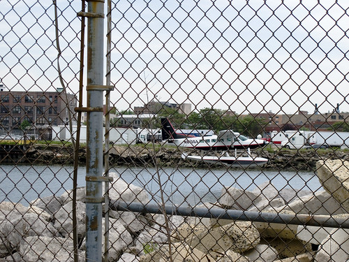
Apocryphal, but authoritative, someone who is “in the know” about the Creek and East River told me ” they ferry rich guys back and forth between the hamptons, fire island, and the city. They try to keep it quiet and not let people know that you can get to the eastern tip of Long Island in only 35 minutes. Its only for the rich, celebrities, and wall street types though”.
Wonder if the rich realize they’re landing in the Newtown Creek?
A Big Dig in Queens
Sorry for the quotidian nature of parts of this post, but if someone says it better and more succinctly than you can- just acknowledge and accredit the source I always say.

Sunnyside Yards, Degnon Terminal- photo by Mitch Waxman
An Observation:
Good old fashioned “Progress” is on the move again in the City of Greater New York.

Sunnyside Yards, from Skillman Avenue- 3 exposure HDR photo by Mitch Waxman
Along the east side in Manhattan, a new subway line is under construction. The project has called for an expansion of the Long Island Rail Road’s cyclopean Sunnyside railyards at the Degnon Terminal here in Queens. (ps- check this video of a ride on the 1950’s Manhattan Third Avenue El at YouTube).
Quoted content from trainsarefun.com
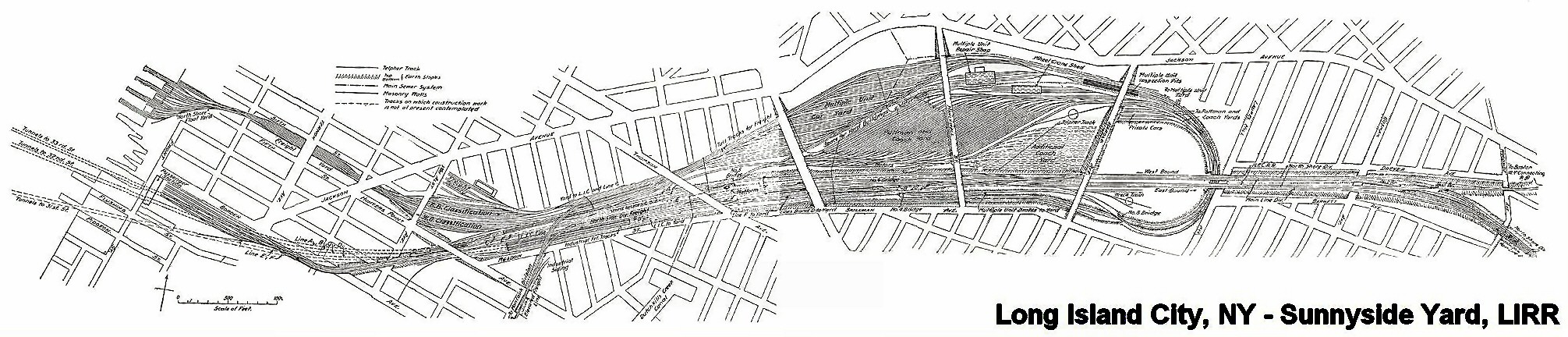
Sunnyside Yard Rendering C. 1905
In 1910 the Pennsylvania Railroad had completed its terminal in New York City, which was connected by tunnels to New Jersey, and under the East River to Long Island. At Sunnyside the large yard of the Pennsylvania Railroad was constructed. An agreement was made with that Railroad and the Pennsylvania Tunnel and Terminal Railroad Company whereby the cars of the Long Island Railroad would be carried through the tunnels under the East River into the Terminal at Seventh Avenue and Thirty-second Street, New York. Thus the Long Island Railroad acquired what successive administrations had striven for in vain, a terminal on Manhattan Island. In order to reach this terminal it was necessary to electrify from Jamaica to New York, which was accomplished in 1910, and the first train run into the Pennsylvania Station on September 10th of that year.
-Felix E. Reifschneider’s 1925 Long Island Rail Road History
I REALLY have to recommend some time spent at Trainsarefun.com for any antiquarian, and especially for the intrepid photographer trying to peel back a few layers. This is one of the best collections of old photos and maps on the Long Island City and Newtown Creek industrial complexes that I’ve found so far. Wow. This is the link to their LIC page (same as one on accredidation).

Sunnyside Yards, Degnon Terminal- photo by Mitch Waxman
The Plan:
as quoted (verbatim) from the wikipedia article on the subject:
Extending between Sunnyside, Queens, and Grand Central Terminal, the East Side Access project will route the LIRR from its Main Line through new track connections in Sunnyside Yard and through the lower level of the existing 63rd Street Tunnel under the East River. In Manhattan, a new tunnel will begin at the western end of the 63rd Street Tunnel at Second Avenue, curving south under Park Avenue and entering a new LIRR terminal beneath Grand Central Terminal.
Current plans call for 24-trains-per-hour service to Grand Central Terminal during peak morning hours, with an estimated 162,000 passenger trips to and from Grand Central on an average weekday. Connections to AirTrain JFK at Jamaica Station in Jamaica, Queens, will facilitate travel to John F. Kennedy International Airport from the East Side of Manhattan.
A new LIRR train station in Sunnyside at Queens Boulevard and Skillman Avenue[1] along the LIRR’s Main Line (into Penn Station) will provide one-stop access for area residents to Midtown Manhattan.[2] The station may spur economic development and growth in Long Island City.
A comment:
Once again, the recurring theme of “spurring development and growth in Long Island City” emerges. Look at the photos here at the Newtown Pentacle, go to our flickr group and see what other people are compelled to record and share. Does this place look undeveloped or undergrown? These are real estate interests talking, trying to grab away what remains of New York’s industrial infrastructure. These buildings are full of companies that employ people in low paying jobs that you don’t need a diploma or even ID to get. Greasy, necessary jobs handling garbage and other things you wouldn’t like to think about. Abattoirs and crematories are part of the story, like sewers and trains, of the greatest metropolis in the history of mankind.

Sunnyside Yards, Degnon Terminal- photo by Mitch Waxman
Minutia:
Degnon Terminal and the Sunnyside Yards are so large and obvious from the air, so critical to the economy and strategic operational capabilities of the United States- that they were designated by the Soviet Union’s Missile Forces as the first strike target in a nuclear attack on the New York Metropolitan area, not Manhattan (which is only a mile and half away, mind you, and would have been obliterated along with the yards).
– I’m trying to back that one up right now, but its something I read a while back- perhaps at conelrad, I’ll find my source on this- I just have to stop looking
-Astoria, incidentally, is where the famous “Duck and Cover” propaganda flick was made (here’s the youtube link).
Astoria and Sunnyside provided a large number of the 16,000 employees who worked here at the Degnon Terminal, almost all of whom belonged to labor unions. These were jobs “with benefits” like health insurance or paid vacations, a rarity before the late 1970’s. The shells of the titanic companies like Adams (Beeman) Chewing Gum, and Sunshine Biscuits line the streets surrounding the yard, but modernity has largely cut their links to it. These industrial buildings- filled piecemeal with dozens of smaller companies- load their containerized goods onto trucks, not trains, and the international port that will ship their products is in Newark, New Jersey.

Sunnyside Yards, this street corner is actually on a bridge over the yards- notice the change in elevation at lower left- still around 30-50 feet (10-15 meters) over the tracks– The structure at horizon is another road bridge over the yards. –3 exposure HDR photo by Mitch Waxman

Sunnyside Yards, Degnon Terminal- photo by Mitch Waxman
An opinion:
These sort of tectonic shifts in the landscape are nothing unusual in New York City, which is not so much a series of individual structures as it is an enormous complex of infrastructure whose every perspective is ultimately centered on Manhattan and whose borders ultimately lie hundreds, if not thousands, of miles away radiating in every direction including out to sea and in the air.

Sunnyside Yards, Degnon Terminal- photo by Mitch Waxman
Here in the Newtown Pentacle, near the very center of this Megalopolis– centuries of power, phone, water, and sewer systems weave around layered building foundations, abandoned trolley lines, and the legacy of the industrial revolution. Deep under the streets, streams and creeks that once ambled over the stubborn hills of New Amsterdam now crash through stone clad sewers in a century clad darkness, mixing with industrial runoff and raw sewage. Even under the best of circumstances, a lot of New York’s untreated waste ends up in the harbor. A significant portion of that dumping, by the City of New York, happens at Newtown Creek.

Sunnyside Yards, Queensboro Plaza Side, also a bridge over the yards- photo by Mitch Waxman
A warning:
In the very near future, vast new residential populations are envisioned to live nearby- at Hunter’s Point, and Queensboro Plaza, and all around the Sunnyside yards, if “growth is spurred”. I’m just an observer, but I’ve watched condo developers carving bloody chunks out of Long Island City, reducing enigmatic and functional structures down to a neighborhood eerily reminiscent of Battery Park City. These new developments are not required to improve the sewers, or build subway stops, or even compel the local electric company to improve the quality of its archaic grid. Can these ancient Newtown foundations support a magnified community they were never designed for?

Newtown Creek Bulkheads- photo by Mitch Waxman
On the waterfront(s), these waters flow into forgotten subterranean vaults, and flow through depression era landfills, swirling through long buried smuggler tunnels and abandoned building foundations on their pathway to the river– silt buried structures which await only the discovery of modernity. All the poisons which lurk in our Newtown mud leech into the water, eventually percolating into the East River and New York Harbor beyond.

Sunnyside Sewer- photo by Mitch Waxman
Who can imagine what might be buried down there, under all the layers of progress, and what the Big Dig in Queens might be stirring up?

Sunnyside Yards, Degnon Terminal- photo by Mitch Waxman
ps: Check out this video at Youtube for sound reasoning on why New York was the center of the universe– it’s Geography!
“Influence of Geography & History on Port of New York 1949”
Rare opportunities…
Working Harbor Committee is scheduling 4 Hidden Harbor Tours this summer – we’ll be on the June 15th one. Don’t miss this, get your tickets and ready your cameras!!!
Big Allis is not in the Land of the Lost… or how I learned to stop worrying and love Ravenswood #3

16% percent of the electricity consumed by New York City is generated at the junction of Vernon and 36th avenues in Queens where the gargantuan Big Allis power plant is found.

The first million kilowatt facility in the entire country, built at the behest of Consolidated Edison, Ravenswood number three first went online in 1965. Upon activation, the cyclopean dynamos of Big Allis were reduced to slag by volcanic emanations issuing from within its massive, natural gas driven turbines.

Six months later, a rebuilt system managed to withstand a full hour and twenty-seven minutes of these cosmic stresses before it too went out of commission for a further four months. The problem was diagnosed by experts and teams of engineers to be the responsibility of a malfunctioning bearing which was producing disharmonious vibrations.

After the blackouts of the late seventies, it seemed that Big Allis had finally been tamed by the tireless labor of the indomitable employees of Consolidated Edison. Perfected, the plant was sold by ConEd to the Keyspan Energy Corporation, which then sold it in 2008 to the TransCanada company for 2.9 billion dollars.
photos by Mitch Waxman
As always, if something you read here is contradicted by something you know, please leave a comment or contact us. Corrections and additions are always welcome.
The Horrors of Hallet’s Cove
On the Queens waterfront, at the junction of Broadway and Vernon Boulevard, can be found the Socrates Sculpture Garden, a very modern warehouse store, and dozens of derelicted industrial mills which define Hallet’s Cove and hint at its hidden past.
quote from myastoria.com:

and from wikipedia:

This area (between the nineteenth century’s American Civil war and the second thirty years war -called World Wars 1 and 2), along with the nearby Newtown Creek, was the busiest industrial manufacturing zone to be found in the entire world.

Today, its an abandoned patch of corrupted ruins whose ancient poisons and toxic filth leech through glass strewn mud into the East River.

I rarely cross a fence line, but this structure seemed to be calling out to me.

Once, this structure had been a metal finishing plant of some kind, but today it serves as a garbage dump for surviving area businesses.

The building is marked as condemned by the inspectors of the New York City Fire Department with a squared X, and apparently for good reason.

Spoke to a Fireman in a bar one night about what the squared x means. Won’t be crossing that mark again.

It disappeared in the spring of 2009, this place on Hallet’s Cove.

What remains is a brick lot with a fence around it.


