Archive for 2012
limned delicately
– photo by Mitch Waxman
One has always enjoyed strange interests and pastimes, even as a child. Vivid, memories of a next door neighbor (who owned a commercial vessel which was part of the Sheepshead Bay fishing fleet) displaying a captured deep sea creature- the sort whose teeth are transparent, skin is shiny black, and bearing a bioluminescent lantern protruding from its forehead- persist decades after viewing it dying in a bucket. Joy is found wandering about cemeteries and wasted heaths, or anyplace shunned by the common gentry.
from “Beyond Good and Evil” by Friedrich Nietzsche, Chapter IV. Apophthegms and Interludes
Wer mit Ungeheuern kämpft, mag zusehn, dass er nicht dabei zum Ungeheuer wird. Und wenn du lange in einen Abgrund blickst, blickt der Abgrund auch in dich hinein.
Translation: He who fights with monsters might take care lest he thereby becomes a monster. And when you gaze long into an abyss the abyss also gazes into you.

– photo by Mitch Waxman
Early experience has led one to appreciate, seek, and cultivate interest in the macabre. Hidden truths, occultist fantasy, the lure of the “real”- all have carried your humble narrator to bizarre locales in search of thrills. Delight is found in jars of formaldehyde cured anatomies, displays of skeletonized life forms, and the arcana of the mortician and police scientist. One thing which bizarre experience has taught me is that there are certain things which cannot be “unseen”, which will alter your perceptions of the normal.
from wikipedia.org
The original Maelstrom (described by Poe and others) is the Moskstraumen, a powerful tidal current in the Lofoten Islands off the Norwegian coast. The Maelstrom is formed by the conjunction of the strong currents that cross the straits (Moskenstraumen) between the islands and the great amplitude of the tides.
In Norwegian the most frequently used name is Moskstraumen or Moskenstraumen (current of [island] Mosken).
The fictional depictions of the Maelstrom by Edgar Allan Poe and Jules Verne describe it as a gigantic circular vortex that reaches the bottom of the ocean, when in fact it is a set of currents and crosscurrents with a rate of 18 km/hr.

– photo by Mitch Waxman
During my student years, a part time job at a photo developing company provided me with visions of horror normally reserved for the world weary gendarme. A certain police command in Brooklyn utilized our services to process evidentiary photographs and videotapes, and the horrors witnessed in these scraps of visual data imparted a real and lasting sympathy for the men and women who operate on the front lines of society. A child half consumed by zoo animals, bodies clad in the proverbial “cement overcoat” hauled from long residency in Jamaica Bay, the hapless victims of vehicular accidents. If you know a cop or ambulance driver, buy them a drink, as they have seen too much.
from The Shadow Over Innsmouth by H. P. Lovecraft
Complaints from many liberal organizations were met with long confidential discussions, and representatives were taken on trips to certain camps and prisons. As a result, these societies became surprisingly passive and reticent. Newspaper men were harder to manage, but seemed largely to cooperate with the government in the end. Only one paper – a tabloid always discounted because of its wild policy – mentioned the deep diving submarine that discharged torpedoes downward in the marine abyss just beyond Devil Reef. That item, gathered by chance in a haunt of sailors, seemed indeed rather far-fetched; since the low, black reef lay a full mile and a half out from Innsmouth Harbour.
People around the country and in the nearby towns muttered a great deal among themselves, but said very little to the outer world. They had talked about dying and half-deserted Innsmouth for nearly a century, and nothing new could be wilder or more hideous than what they had whispered and hinted at years before. Many things had taught them secretiveness, and there was no need to exert pressure on them. Besides, they really knew little; for wide salt marshes, desolate and unpeopled, kept neighbors off from Innsmouth on the landward side.
 – photo by Mitch Waxman
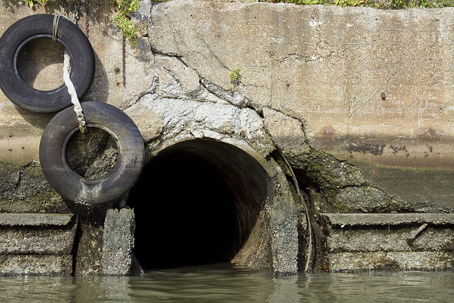
Perhaps this is why, whenever I am on Newtown Creek (which is rather frequently, after all) insistence on getting close to the open intestines of the cruel megalopolis is insisted on by your humble narrator. Miasmal, these pipeways contain the hidden and truly occult unknowable. Darkness shrouds and shelters unknowable realities in this system of engineered horror, whose construction largely dates back to a time in which a Kaiser still ruled Germany. An extensive urban mythology exists which speculates upon what might be found in this kingdom of the rat, along those weirs and subterranean grottoes fed by decay, filth, and all that which might be discarded by the sunlit world above.
Truly- who can guess, all that there is, that might be buried down here?
from “The Divine Comedy by Dante Alighieri“, translated by Henry Wadsworth Longfellow Inferno, Canto III
“Through me the way into the suffering city,
Through me the way to the eternal pain,
Through me the way that runs among the lost.
Justice urged on my high artificer;
My maker was divine authority,
The highest wisdom, and the primal love.
Before me nothing but eternal things were made,
And I endure eternally.
Abandon every hope, ye who enter here.”
old manor

– photo by Mitch Waxman
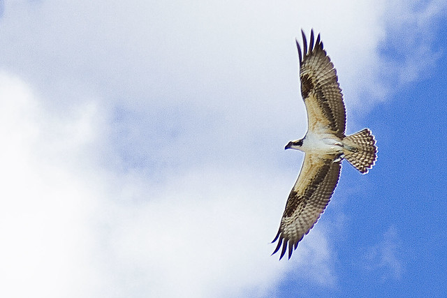
It may have been noticed, lords and ladies, that several shots of the loquacious Newtown Creek from an odd angle have appeared at this- your Newtown Pentacle- in the last few days. Your humble narrator recently found himself coerced into a bird watching expedition, by canoe, by certain powers and potentates of the Newtown Creek Alliance. It should be explained, as it has been mentioned in the past, that if the leadership of NCA can be analogized as the “Super Friends“- your humble narrator plays the role of Gleek the super monkey in the group.
Accordingly, when they ask me to go bird watching on Newtown Creek in a canoe with the North Brooklyn Boat Club, I go.
Hey, look, we saw an Osprey.
from wikipedia
The Osprey (Pandion haliaetus), sometimes known as the sea hawk, fish eagle or fish hawk, is a diurnal, fish-eating bird of prey. It is a large raptor, reaching more than 60 cm (24 in) in length and 180 cm (71 in) across the wings. It is brown on the upperparts and predominantly greyish on the head and underparts, with a black eye patch and wings.
The Osprey tolerates a wide variety of habitats, nesting in any location near a body of water providing an adequate food supply. It is found on all continents except Antarctica although in South America it occurs only as a non-breeding migrant.
As its other common name suggests, the Osprey’s diet consists almost exclusively of fish. It possesses specialised physical characteristics and exhibits unique behaviour to assist in hunting and catching prey. As a result of these unique characteristics, it has been given its own taxonomic genus, Pandion and family, Pandionidae. Four subspecies are usually recognised. Despite its propensity to nest near water, the Osprey is not a sea-eagle.

– photo by Mitch Waxman
Personal preference for motorized transport on the water aside, the folks from the North Brooklyn Boat House took great care of us and the afternoon went pretty well. Aside from the Osprey, we witnessed several other avian critters- including the Great Blue Heron which I’ve been chasing around the Creek all year. Unfortunately, the camera rig I carry isn’t purpose built for this sort of thing. The images in today’s post are pretty close to “actual pixels”, a 100% crop of a larger image, and look a bit rougher than my normal photos accordingly.
Bird photography, done properly, requires a powerful and expensive lens to get right.
from nytimes.com
Ospreys — large birds with dramatic brown and white markings and four-foot wing spans — occupy the top of the food chain, eating all kinds of fish, and are thus important indicators of the health of their environment. Along with other birds of prey, they were decimated by the widespread use of the pesticide DDT in the 1950s and ’60s, which led to a thinning of eggshells. Once DDT was banned in 1972, however, ospreys began a remarkable comeback, especially in the Northeast.
– photo by Mitch Waxman
Even those of us familiar with the Creeklands have been startled by the diversity of specie observed during these surveys. Your humble narrator, as an omnivore consumer of visual data, has little to no expertise in such matters- but those well versed with ornithological endeavors have been left slack jawed at the thriving ecosystem observed around the so called “dead sea” of the Newtown Creek.
from dec.ny.gov
The osprey is probably the longest studied and monitored raptor in New York. The New York State Department of Environmental Conservation (NYSDEC) monitors the status and productivity of the majority of New York’s population. Each year, both ground and aerial surveys are conducted by NYSDEC to document osprey nests in the state.
From 1980-1987, the NYSDEC released 36 young ospreys taken from nests on Long Island in an attempt to establish a third or “satellite” population in southwestern New York. During the seven years of the project, 30 young ospreys were released into the wild. This has lead to successful nests in the area, including nine nesting pairs in 1998. There are also close to a dozen breeding pairs in central New York and one in Southeastern New York in Sullivan County.
endless formulae

– photo by Mitch Waxman
Welcome to DUBABO, Down Under the Borden Avenue Bridge Onramp, along the loathsome Dutch Kills tributary of the Newtown Creek. Dutch Kills is an ancestral waterway which once suffused into the swampy tidal flats which the Netherlands colonists stumbled across in the 1640’s, and which are described in the historical record as having been “malarial, and mosquito ridden”. The waterway once ran as far inland as modern day Queens Plaza, but the entire coastline of western Long Island was riddled with shallow waterways back then, which fed a thriving wetland. Sunswick, Jack’s, Wolf’s, English Kills, Maspeth, Bushwick, and the largest- Newtown- Creeks macerated the shoreline and allowed tidal nutrients to suffuse into the soil.
from a 2011 newtownpentacle posting, “uncommented masonry”
Borden Avenue is one of the older pathways in New York and particularly so for Queens, as the modern street was designated as Borden Avenue in 1868. It allowed egress from the docks at Hunters Point to the incalculably far Newtown and passed by the thriving village of Maspeth along the way. Originally a plank road set roughly into the swampy lowlands which adjoined the Newtown Creek, what would become Borden Avenue eventually progressed to the point of regular horse drawn (and then electric) street car service by the late 19th century and beginning of the 20th. It became a natural place for heavy industries to gather, and in the 1870′s and 80′s, rail road switches and “rights of way” followed their customers here.
The Long Island Railroad terminal at Hunters Point is and was on Borden Avenue, and rail tracks run parallel to Borden Avenue’s path, along what would have once been known as Creek Street. Critically, these were both freight and passenger tracks.
As of 1908, a retractile vehicle bridge crossed Dutch Kills, which we call the Borden Avenue Bridge (and which replaced the earlier wooden plank road drawbridge).

– photo by Mitch Waxman
No secret, Borden Avenue Bridge is my second favorite of the many movable spans around the Newtown Creek watershed (Grand Street is tops). The entire surface of the structure is designed to physically roll away from its piers, on rails, and retract into a pocket- ostensibly allowing maritime traffic egress to commercial docks. Dutch Kills used to be a well used and quite busy thoroughfare for such traffic, although lately- not so much.
from the NYC DOT site
Borden Avenue is a two-lane local City street in Queens. Borden Avenue runs east-west extending from Second Street at the East River to Greenpoint Avenue. The Borden Avenue Bridge over Dutch Kills is located just south of the Long Island Expressway between 27th Street and Review Avenue in the Sunnyside section of Queens. Borden Avenue Bridge is a retractile type moveable bridge. The general appearance of the bridge remains the same as when it was first opened in 1908. The bridge structure carries a two-lane two-way vehicular roadway with sidewalks on either side. The roadway width is 10.5m and the sidewalks are 2.0 m. The west approach and east approach roadways, which are wider than the bridge roadway, are 15.3m and 13.0m respectively. The bridge provides a horizontal clearance of 14.9m and a vertical clearance in the closed position of 1.2m at MHW and 2.7m at MLW.

– photo by Mitch Waxman
The water quality at Dutch Kills is fairly nightmarish, with “floatables” and wind blown trash collecting along the bulkheads. The water betrays itself with the odd colors (and colour) it displays, ranging from a reddish brown after rain events to a cadmium green during the heights of summer and depths of winter. Unnaturally still, the only flow of water here is driven by the tepid tidal flow of the larger Newtown Creek or by the expulsion of waste water and storm runoff from the Combined Sewer Outfalls found along its banks.
from wikipedia
Dutch Kills is a sub-division of the larger neighborhood of Long Island City in the New York City borough of Queens. It was a hamlet, named for its navigable tributary of Newtown Creek, that occupied what today is centrally Queensboro Plaza. Dutch Kills was an important road hub during the American Revolutionary War, and the site of a British Army garrison from 1776 to 1783. The area supported farms during the 19th Century, and finally consolidated in 1870 with the villages of Astoria, Ravenswood, Hunters Point, Middletown, Sunnyside and Bowery Bay to form Long Island City.

– photo by Mitch Waxman
Scientific analysis of the water, offered in now decades old reports by the United States Army Corps of Engineers and the far ranging Hydroqual studies of the watershed in the 1990’s, describe the presence of a millimeter thick layer of fats and lipids overlying the water. This medium allows bacterial specie to survive in the open water, and such sewage borne pathogens are abundant. Typhus, cholera, and gonorrhea- for instance- are all mentioned. Additionally, like all the waters of NY Harbor, but especially concentrated at Dutch Kills (and all around the larger Creek) due to the abundance of CSO’s- one can expect to find elevated levels of prescription drug residue carried in by sewer discharge.
from nysdot.gov
About 1900, most of the Newtown Creek was bulkheaded and occupied by about fifty industrial properties. Undeveloped or less developed sections without bulkheads included Dutch Kills, about 2,000 feet of shoreline in Queens just above Dutch Kills with two LIRR lighterage piers, about 1,000 feet of shoreline in Queens near the Penny Bridge, and about 3,500 feet of shoreline downstream of Maspeth Avenue in Brooklyn.15 Dutch Kills, and the Queens side of Newtown Creek, just upstream of Dutch Kills, were developed circa 1905-1912, largely through the efforts of the Degnon Terminal & Realty Company. The Degnon firm created an industrial park with rail and marine access around Dutch Kills between about Hunters Point and 47th Avenue, Dutch Kills subsequently was included within USACE dredging projects. Without federal assistance, Degnon created a 150-foot-wide channel with 2,400 feet of bulkhead, including a turning basin.

– photo by Mitch Waxman
DUBABO was one of the spots recently targeted by the IEC organization during “Shoreline Cleanup day”, and event in which Newtown Creek Alliance participated. IEC musters crews of volunteers who literally pick up the trash. Other harbor groups participated in the cleanup in Queens, and efforts were made literally all along the east river coast of the borough, from Astoria Park all the way to Hunters Point. Arrangements were made with a carting firm, in our case Waste Management, to dispose of the collected materials, after it had been weighed and categorized. NCA’s mission is to “Reveal, Restore, Revitalize” the Newtown Creek, after all, and “a great starting point for any project is picking the crap up off the floor first”, as my dad might have said.
from a 2011 newtownpentacle posting, “ponderous and forbidding”
All across Dutch Kills, everything bore that unmistakable colour which typifies the lament and sickness of the Newtown Creek watershed. Iridescent, it is neither black nor white nor any normal color, rather it’s is like something alien coating everything in rotten decay. Metal corrodes, wood molders, stone and cement simply crumble away.
The swampy wetlands which existed here in aboriginal times were known as the Waste Meadows in the 19th century, and perhaps this is still the appropriate terminology for them.
central chamber

– photo by Mitch Waxman
Recently, while out on the Newtown Creek on a Newtown Creek Alliance mission, the inestimable Executive Director of the group – Kate Zidar- gestured toward a certain structure on the Queens side and asked me what I knew about it. My mandate in the organization is to act as historian, as well as photographer, and the building in question is known to modernity as the “Lukoil Getty Terminal”. It’s waterfront is categorized by Dock Code 616, a 300 foot frontage, and it sits in plain view of the Greenpoint Avenue Bridge.
To me, it will always be referred to as Tidewater.
from wikipedia
Tidewater Oil Company (also rendered as Tide Water Oil Company) was a major petroleum refining and marketing concern in the United States for more than 80 years. Tidewater was best known for its Flying A–branded products and gas stations, and for Veedol motor oil, which was known throughout the world.
Tidewater was founded in New York City in 1887. The company entered the gasoline market just before World War I, and by 1920 was selling gasoline, oil and other products on the East Coast under its Tydol brand. In 1931, Tidewater expanded its reach into the midwestern U.S. by purchasing Northwestern Oil Company of Superior, Wisconsin.
Soon thereafter, Standard Oil Company of New Jersey (now ExxonMobil) gained control of Tidewater, and set up the subsidiary Mission Corporation to operate it. J. Paul Getty’s purchase of Mission in 1937 set the stage for the birth of Tidewater as a major national player in the oil industry.
In 1938, Getty merged Tidewater with Associated Oil Company, based in San Francisco with a market area limited to the Far West. Associated, founded in 1901, had created the prominent Flying A brand for its premium-grade gasoline in 1932.
With the merger and creation of Tidewater Associated Oil Company, Flying A became the primary brand name for the company, though the Tydol and Associated names were also retained in their respective marketing areas. Tydol During the 1950s, the Associated and Tydol brands gradually fell into disuse, and were dropped entirely in 1956. That same year, “Associated” was removed from the corporate name. The Veedol trademark was retained for motor oils and lubricants. BP acquired the Veedol brand when it bought Burmah-Castrol (who then owned the Veedol brand). In February 2011 announced that they wished to sell the Veedol Brand. Tidewater operated refineries on both the Atlantic and Pacific coasts, as well as a small fleet of West Coast-based tankers.

– photo by Mitch Waxman
In the early years of the American Oil industry, it seems, there were literally hundreds of small players who drilled or refined petroleum. A behemoth which emerged from the crowded field, that would dominate the sector in one way or another to this very day, was John D Rockefeller’s Standard Oil. Standard controlled the means of delivery, whether it be defacto control of the rail lines leading from oil rich regions (which were in Pennsylvania, back then) to refinery, or through ownership of the local pipelines which supplied their refined product to end use customers.
This allowed Standard to fix prices at a certain level, manipulate supply and demand in its own favor, or to keep competitors from getting their goods to market.
from 1919’s “Platts power, Volume 50“. courtesy google books
N.Y., Long Island City – The Tidewater Oil Co., 11 Broadway New York City, awarded the contract for the construction of a 2 story 30 x 140 ft warehouse on Greenpoint Ave and Newtown Creek, to H.D. Best, 949 Broadway, New York City. A steam heating system will be installed in same

– photo by Mitch Waxman
Unfair and underhanded, the Standard Trust went out of its way to destroy or stifle its competition and before long it controlled 90-95% of the oil business in the United States. Competitors came along as the years passed, most of which fell before the attentions of the Rockefellers. Some, like Charles Pratt, sold their operations to Standard and joined with it. Others were driven into bankruptcy. Technological advances and invention offered an opportunity to bypass the rail system dominated by the trust, and the dream of a pipeline which would feed oil to the independent refineries on the Atlantic coast of the United States became feasible.
The company that crystallized this challenge to Standard was the Tidewater Oil Company.
from 1889’s “Stoddart’s Encyclopaedia Americana: a dictionary of arts, sciences, and general literature“, courtesy google books

– photo by Mitch Waxman
For many years, Rockefeller and his Standard men (with their armies of bought and paid for politicians and local officials) ridiculed and fought against the pipeline company, but when his independent competitors banded together under the Tidewater brand in the 1870’s – he knew that Standard must innovate. In one of the first business moves of its kind, Standard began purchasing common stock in Tidewater, and by 1883 controlled a majority share in it.
Rather than using the well honed “breaking” techniques of industrial monopoly on the rival company, Rockefeller simply purchased his competition.
from “Harper’s magazine, Volume 72“, courtesy google books
– photo by Mitch Waxman
As an aside, it should be noted that the path Greenpoint Avenue takes, in modernity, as it crosses the Newtown Creek is slightly eastward of its ancient footprint. The modern bridge, which replaced an older swing bridge that carried LIRR and light rail tracks as well as vehicles, actually pulls traffic away from the ancestral road. In the early 20th century LUNA image linked to below, which is the inverse of my recent shot above, notice that only the bridge and rail tracks are still in place.
The Tidewater building would be to the left in the historic shot below.

X

– photo by Mitch Waxman
A recommended primer for anyone interested in the story of the early American Oil industry is “The History of the Standard Oil Company, By Ida Minerva Tarbell“, an admittedly biased and muckraking account told by the daughter of an oil pioneer whose business was wiped out by the Standard Trust. Tarbell disliked the term muckraker, and considering that she was a pioneering female journalist and investigative reporter in an age not exactly known for either- let’s just respect her wishes.
from “The History of the Standard Oil Company, Volume 2 By Ida Minerva Tarbell” courtesy google books

– photo by Mitch Waxman
Like most who opposed Rockefeller, who would die as the richest man in human history (in fact, adjusting for inflation- Rockefeller died richer than Augustus of Rome, and all the Pharoahs of Egypt, and all the kings of England- put together) Tidewater ended up a footnote, and being used as an instrument by which Standard could further dominate the competition.
Standard was broken up by the actions of the federal government in the early 20th century, shattered into several smaller corporations. Standard Oil Company of NY (SOCONY) was one of these, and it would become Mobil. Standard Oil Company of NJ (SOCONJ) would become Exxon.
Rockefeller’s bank account would one day attain sentience and become Chase Manhattan bank.
from wikipedia
In 1904, Standard controlled 91% of production and 85% of final sales. Most of its output was kerosene, of which 55% was exported around the world. After 1900 it did not try to force competitors out of business by underpricing them. The federal Commissioner of Corporations studied Standard’s operations from the period of 1904 to 1906 and concluded that “beyond question… the dominant position of the Standard Oil Company in the refining industry was due to unfair practices—to abuse of the control of pipe-lines, to railroad discriminations, and to unfair methods of competition in the sale of the refined petroleum products”.
things sobbing

– photo by Mitch Waxman
Like the Lois Ann L Moran in a graving dock, pictured above, this maritime sunday was not spent hard at work for your humble narrator. A marathon viewing of a cache of latter day Godzilla movies literally has stomped into my weekend, obliterating all productivity as if by a blast of atomic fire breath. This post, as is very thing else besides Godzilla (for instance- hygiene, exercise, conversation), is obligatory at this point in time. At this writing, your humble couch potato is midway through Godzilla versus Destoroyah, and on his way to “Final Wars”. Wish me luck.


