ponderous and forbidding

– photo by Mitch Waxman
As mentioned in a post the other day, an opportunity arose for me to accompany a representative of Riverkeeper on a survey mission to Newtown Creek recently.
Demanded by the top leadership of the Newtown Creek Alliance itself, this was an expedition whose agenda would require the photographic documentation of bulkheads and shoreline conditions all along the Creek. Of special interest to those involved in the renewal and resuscitation of brownfield sites, the mission as put forward was to get a shot of everything possible. This survey would include observation of the lesser known tributaries of the Creek- Dutch and English Kills, as well as Maspeth Creek, and the East and West Branches which lie beyond the Grand Street Bridge.

– photo by Mitch Waxman
The barriers which guard the secrets of Dutch Kills, which branches from the main body of Newtown Creek just .8 of a mile from it’s locus point with the East River, are two rail bridges. As mentioned in the past, I am no expert on the intricacies of the trackways which snake around the Queens side of the Creek. The expert on this subject was Bernard Ente, who recently passed away, and I wouldn’t offend his memory by pretending to know more than the following:
Neither Bridge (both are moveable) has opened for some time, and it is my understanding that they are part of the “Montauk Cutoff”.

– photo by Mitch Waxman
The survey team was small, as we were in a tiny craft. Hardly more than a rowboat with an outboard motor, three of us sat less than a few inches above the water. There was a mist hanging in the air, as it was early morning, which was quite invisible to the eye but will occasionally become visible in these shots (when I fired off the flash).
Our plan was to take advantage of high and low tides to gain access to the various sections which we were mandated to record, and the low ceiling of the swing bridge at Dutch Kills demanded we make our attempt at ebb tide and exit the tributary before it again flooded.

– photo by Mitch Waxman
I will admit to prayer that a train might pass overhead, for this would be a prize photo for your humble narrator, but alas- no such luck. I don’t know very much about the rails, but I do like taking pictures of trains from odd angles. There was a ghastly sensation afoot in me as well, as I knew that the very air which we were breathing was a hideous miasma of vapor emissions rising from the poison sediments which line the bed of Dutch Kills.
Everywhere, there were tiny bubbles erupting to the surface of the water, and as we disturbed them- mephitic smells swirled about and enveloped the boat.

– photo by Mitch Waxman
Many times have I been down Newtown Creek on the water, but it has always been in nothing smaller than a NY Water Taxi. Additionally, Dutch Kills is “mine”, a branch of the Creek that has received extensive study and historical analysis here at Newtown Pentacle as well as having been thoroughly catalogued photographically. No surprises in store here thought I, English Kills is a bit more “unknown territory” and would likely yield something to hang my hat on.
That is what I thought at the start of this trip.

– photo by Mitch Waxman
To start, the first rail bridge seems to be in a deep state of corrosion, which would make sense given its century long existence. I am no engineer, of course, but this thing hasn’t seen a paint brush in a very long time.
Witnessing the rust and metal fatigue on this bridge actually made me glad that a train wasn’t passing by overhead. The works and motors which power this bridge’s swing action have been burnt out for some time I am told.

– photo by Mitch Waxman
I have never seen it happen (as you would have seen a photo of it here by now) but word is that if the bridge needed to be opened, rail workers would utilize the sort of tow trucks known as “wreckers”, situated at both banks, to winch the thing open.
Sounds bizarre, but the aforementioned Bernard Ente told me that one, and “Bernie was always right” about this sort of thing. Can’t tell you how many crazy stories he would tell me about the history and lore of this place, which my own research would prove him to have been purposely understating.

– photo by Mitch Waxman
All across Dutch Kills, everything bore that unmistakable colour which typifies the lament and sickness of the Newtown Creek watershed. Iridescent, it is neither black nor white nor any normal color, rather it’s is like something alien coating everything in rotten decay. Metal corrodes, wood molders, stone and cement simply crumble away.
The swampy wetlands which existed here in aboriginal times were known as the Waste Meadows in the 19th century, and perhaps this is still the appropriate terminology for them.
– photo by Mitch Waxman
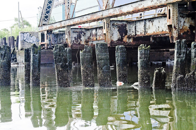
Pilings and structural elements squamously protrude from the water, whose surface seems thicker than expectation would predict. Normal fluid dynamics apply of course, but the turgid waves behaved in the manner of a broth or syrup as opposed to the more wholesome (but still polluted) water found on the nearby East River.
Additionally, high tide was not marked by invertebrate communities of barnacles or mussels here, but rather by tree ring like deposits of sediment.

– photo by Mitch Waxman
Looking back toward the swing bridge, in the direction of infinite Brooklyn, a long walkway is attached to the pier which the bridge is anchored into.
One thing which I can categorically show in these “bulkhead survey” shots of the Newtown Creek, is that much of the so called land along the Queens bank of the Creek (and large parts of English Kills in Brooklyn) is actually an engineered surface of pilings intermixed with fill and capped with a cement slab- reclaimed land.
One of the scarier ramifications of this, and again– not an engineer- is witnessed in the deleterious condition of these century old wood pilings visible from the water’s edge.

– photo by Mitch Waxman
Next up on this trip is the truss rail bridge, which is built quite a bit higher in elevation than the initial structure and is found at the other side of the pier and walkway which connects to the Swing Bridge. It’s a drawbridge, and the elevated height must have been part of a plan to reduce the need to open the span for water traffic on the once busy Dutch Kills.

– photo by Mitch Waxman
Apologies are offered for vagueness, lords and ladies, as I fear that I’ve spoiled you over the last several years with vulgar displays of “info-porn”. Normally, you’d be reading stats and figures, hearing the name of engineers and learning of long forgotten disasters. Unfortunately, as these two bridges are not publicly accessible, and to study them in any real detail would mean trespassing and demand mandatory jail time… these are the bridge structures which I can describe in the least detail anywhere along Newtown Creek.
Railfans of NYC, anonymous LIRR employees, please leave a comment below and share the wisdom.
As mentioned in the past- I never trespass- like a Vampire your humble narrator needs to be invited inside to do his best work and in the age of terror- no one is invited to look too closely at railroad infrastructure.

– photo by Mitch Waxman
Others, however, are not as constrained as I.
A garish banner caught my eye as we passed beneath the truss bridge. My mind concocted that I was seeing just another windblown tarp or plastic container bag at first, but then as we approached… I realized that it was some kind of painting.

– photo by Mitch Waxman
Hung at a level which allows it to interact with the high tide level, this painting seems to depict- to my eye- a middle eastern city withering in flame beneath the burning thermonuclear eye of god.
What’s more, for once, I can brag to Ms. Heather, over at ny-shitty.com, that I finally got something before she did.
Note: as always, clicking the photo will open a new window at Flickr. Clicking the view all sizes option under the “actions” tab will take you to ever larger incarnations of the shot for closer examination. If anyone knows who the artist is, or what this situation is about, I’d love to hear about it.

– photo by Mitch Waxman
It would seem that someone has set up camp under here, or perhaps it is just a studio space. The undocumented men and women who live in both these “Waste Meadows” -and the Newtown Creek watershed as a whole- are too numerous to count. Many are exactly where they belong, while others are trapped by circumstance and ill omen.
All need to be coaxed away from this place, before the Creek does to them what it has to so many others in Greenpoint and Long Island City.

– photo by Mitch Waxman
No human being should be living in this place, except as part of a penal sentence for an especially heinous offense. Trolls live under bridges, not Americans. Additionally, in the age of terror, how exactly does this go unnoticed by the gendarme?
I cannot stress how often I ask this question as I wander across the Creeklands.

– photo by Mitch Waxman
Despite the fearful atmospherics and forbidding appearance of the water, we pressed on. Our steward from Riverkeeper kept a steady hand on the outboard motor and the tiny boat slid forward across Dutch Kills. This shot is looking back at the two rail bridges of the Montauk Cutoff which we had just passed beneath.
Still no trains.

– photo by Mitch Waxman
Dead ahead was the Borden Avenue Bridge and the high flying Long Island Expressway, the experiencing of which which will be discussed tomorrow at this- your Newtown Pentacle.


Once again excellent photos, (and better you then me). Just a bit of information to help out.
The Montauk cut-off is the set of tracks that branches off the Montauk Branch at Bliss Tower (just west of the Greenpoint Avenue Bridge) and goes towards Sunnyside Yard.
The truss bridge is called “DB Cabin” and is on the LIRR Montauk Branch (Starts/ends at LIC yard, depending upon ones perspective)
The Bascule bridge is called “Cabin M ” and that bridge is on the Montauk Cut-off proper.
Freight trains(mostly) use(d) the cut-off to get from the Sunnyside freight yards, (Arch Street Yard is all that remains active) and transfer bridges (now Gantry Park) to head east towards Fresh Pond Yard and points further east.
Always curious as to how the LIRR called railroad operation towers “cabins”
John
August 19, 2011 at 11:04 am
[…] The launch we were in had been referred to as the “tin boat” by the Riverkeeper folks, but it was more a smallish rowboat with an outboard engine than anything else. This is the second post of this adventure, click here for the first one. […]
ethereal character « The Newtown Pentacle
August 20, 2011 at 11:42 pm
[…] mentioned in prior postings (parts one and two), the Newtown Creek Alliance had tasked a small group of it’s members (myself […]
pillars and niches « The Newtown Pentacle
August 21, 2011 at 10:57 pm
[…] or parts one, two, and three of this trip down Dutch Kills. This is the last of the four postings describing […]
another aperture « The Newtown Pentacle
August 22, 2011 at 4:03 pm
[…] Zone A, and an extraordinary small boat journey around Dutch Kills was detailed in: “ponderous and forbidding“, “ethereal character“, “pillars and niches“, and “another […]
warnings and prophecies « The Newtown Pentacle
December 31, 2011 at 12:16 am
[…] from a 2011 newtownpentacle posting, “ponderous and forbidding“ […]
endless formulae « The Newtown Pentacle
September 25, 2012 at 11:39 am