Posts Tagged ‘East Elmhurst’
youth’s madness
East Elmhurst.

– photo by Mitch Waxman
As described yesterday, I uncharacteristically rode a bus from Astoria to East Elmhurst in order to get into the right spot for some “waving the camera around” action, which deposited me a few blocks away from my destination. A scuttling I went, heading eastwards on Astoria Blvd. I was heading for the zone I describe as “where Boulevards collide” or “just so Robert Moses.” It’s where Ditmars, Astoria, and Northern Blvd. all smash together with the Grand Central Parkway and Citifield at the edge of Flushing. You’ll be walking down the sidewalk in certain spots, and all of a sudden find yourself walking onto an off ramp to the highway.
One of the least pedestrian friendly spots in Queens, I tell you, although I’ve only been through here a few times.

– photo by Mitch Waxman
On my way, I spotted this tiny domestic survivor from long ago on Astoria Blvd. Itty bitty and wood framed, it had advertisements in its windows advertising a “Cuarto en renta” (room for rent). Something about the propert caught my eye, and instinct told me that “something has happened here.” Can’t tell you what, didn’t do the research on the property, but usually if something catches my eye the way this place did…
I’ll look into it.

– photo by Mitch Waxman
That’s one of the entranceways to the Flushing Bay Promenade pictured above, which is actually a pedestrian bridge overflying the Grand Central Parkway with Flushing Bay beyond. LaGuardia Airport is to the west, Flushing Meadows Corona Park to the east. Directly north is Flushing Bay, and as you can discern from the shot above, I arrived right on time just as the burning thermonuclear eye of God itself had ducked behind Manhattan. The night time, it’s the right time, I say.
More tomorrow.
“follow” me on Twitter- @newtownpentacle
impecuniuous residue
It’s National Animal Crackers Day, in these United States.

– photo by Mitch Waxman
Wandering about one recent afternoon, one found himself at the junction – or “angle” as I’ve coined it – between Woodside’s northern boundary, Astoria’s Southeast extent, and might be Jackson Heights’ western edge. Or at least I think that’s how you’d describe the zone found around Northern Blvd.’s intersection with Broadway. Over by the Newtown Creek, I can tell you the exact spot where it stops being LIC and starts being Maspeth, or say categorically where LIC ends and Woodside begins – but it’s these weird border spots – or angles – between the old municipalities where things get hazy. Suffice to say that if your zip code starts with “111” you live in what was once the independent municipality of LIC.
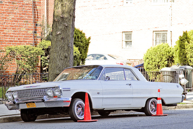
At any rate, I spotted a few cool cars on my walk which I figured I’d show you today. The one above looked to me like it had starred in an action movie and come back worse for wear.
– photo by Mitch Waxman
That’s a Chevrolet above, whose styling makes me say “early 1960’s” but I’ll be damned if I can tell you exactly what model or year it is is. It’s definitely been “modded” a bit, owing to the small tires and probable hydraulic shocks of the “LA gangbanger” style. I was more in the “get some exercise” than “photowalk” mode when it was encountered and didn’t really want to break stride to go and read the registration sticker. At the rear fender, there’s a bit of chrome that reads “ss” so maybe that’s a clue for one of your gear heads who might be reading this.
If you recognize the model, please share with the rest of us in the comments section.

– photo by Mitch Waxman
That’s an Oldsmobile Ninety Eight above, which is likely a “fifth generation” 1957 or 1958 model. They didn’t spell out “ninety eight” until 1958, which is how I can date it. Chevrolet used the numerals “98” instead for the prior models of their luxury models in this line. The “sixth generation” which began to be manufactured in 1959 is an entirely different sort of car with tail fins and a more “modern” profile. As you can see, this old road warrior is in fairly tremulous condition, but the good news is that the auto shop which I spotted it in front of on 32nd avenue specializes in restoring old cars.
Upcoming Tours and events
First Calvary Cemetery walking tour, May 6th.
With Atlas Obscura’s Obscura Day 2017, Calvary Cemetery Walking Tour – details and tix here.
MAS Janeswalk free walking tour, May 7th.
Visit the new Newtown Creek Alliance/Broadway Stages green roof, and the NCA North Henry Street Project – details and tix here.
“follow” me on Twitter- @newtownpentacle
without warning
A fairly novel spot found in north western Queens, in today’s post.
– photo by Mitch Waxman
As mentioned last week, one enacted a “bat out of hell” protocol when Our Lady of the Pentacle allowed me a brief furlough from a kitchen renovation project here at HQ. My perambulation was committed in an easterly direction along Northern Blvd., which ceases to be pedestrian friendly at 114th street. A northerly turn found me at the intersection of Astoria Blvd. and Ditmars, and since it was a warm afternoon, tree lined Ditmars was the route I elected to take back towards the rolling hills of almond eyed Astoria.
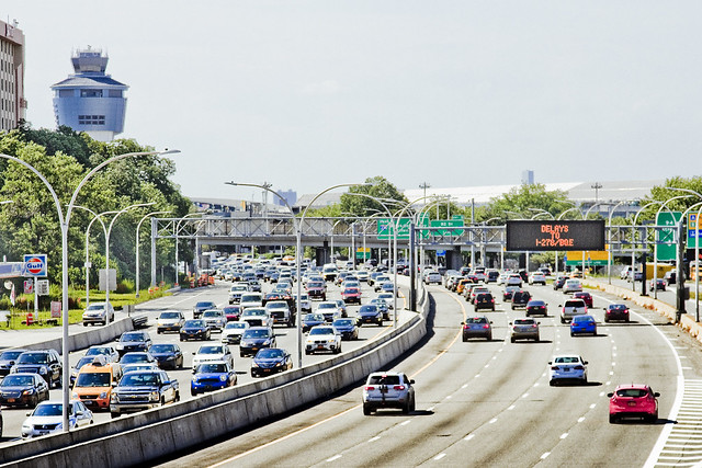
When you say “North Western Queens,” one thinks of jails and airports and power plants and stadiums, and as pictured above – the barrier parkway known as the Grand Central.
There is, however, something else found hereabouts.

– photo by Mitch Waxman
Along Ditmars Blvd., this inviting pedestrian path beckons. Signage found at its intersection informs that this is NYC Parks Department property, and a part of the Flushing Meadows Corona complex.

– photo by Mitch Waxman
The Worlds Fair Marina is noticed first, a boat basin servicing a fleet of privately owned pleasure craft.

– photo by Mitch Waxman
Then, looking to the west and LaGuardia Airport, you observe a part of the Flushing Bay Promenade. Asking around at my local bar, none of the native Astorian lifers even knew this park existed.
Perhaps it’s better known in East Elmhurst, which is the community that hosts it, but my Astoria peeps professed complete ignorance on the subject.

– photo by Mitch Waxman
To the east, something that every Queensican is intimately aware of will be found, the home of our lamentable Mets baseball team at Citifield. Just beyond the stadium are the main sections of Flushing Meadows Corona Park.

– photo by Mitch Waxman
To the west is LaGuardia Airport, and this spot along Flushing Bay was a great location from which to observe the goings on thereabouts.
The NYC Parks Dept. makes this page available at their website, describing the history and rather recent creation of the Flushing Bay Promenade, which is connected to the presence of a large NYC DEP “Combined Sewer Outfall” gray infrastructure project nearby.

– photo by Mitch Waxman
At the western edge of the park was a somewhat natural shoreline, and lots of birds were observed flitting about. Luckily it was high tide when I was visiting, as anyone who has driven along the Grand Central Parkway can describe the sickening rotten egg smell which out gasses from the mud flats here at low tide.

– photo by Mitch Waxman
A smallish homeless camp was observed right along the walls of LaGuardia Airport, and there were makeshift shanties and fabric tents arrayed amongst the tree line. I didn’t venture into the area any further than as indicated in the shot above, however, as I avoid taking shots of residences no matter what their status is.

– photo by Mitch Waxman
The high speed road known as the Grand Central Parkway, pictured above as seen from within the Flushing Bay Promenade, was constructed in the 1930’s. Part of the Triborough Bridge build out, the Grand Central was widened in the post WW2 period to its current dimensions. Another project from the House of Moses.
Robert Moses was a very clever man who mastered the bureacracy of State, City, and Federal highway systems – earning himself the appellations of both “Master Builder” and “Power Broker.” Moses held near absolute power over highway and bridge building, as well as public housing and parks, for nearly forty years before Governor Nelson Rockefeller ousted him from government in 1974.
The NYC we all know is the City that Moses built.

– photo by Mitch Waxman
As with all things government, specificity is key to understanding a thing. The reason that it’s the Grand Central “Parkway,” instead of highway or expressway, are the grassy and wooded medians that run alongside it. Since these medians are titular “parklands,” Moses had broader powers of eminent domain when claiming and remodeling the area to drive a high speed road through it.
Moses also built LaGuardia Airport, incidentally.
“follow” me on Twitter- @newtownpentacle
Upcoming Tours –
August 2nd, 2015
The Insalubrious Valley of the Newtown Creek – Bushwick & Mapeth Walking Tour
with Newtown Creek Alliance, click here for details and tickets.
August 8th, 2015
13 Steps Around Dutch Kills – LIC Walking Tour
with Atlas Obscura, click here for details and tickets
portal guardians
Hatches abound in the Newtown Pentacle.

– photo by Mitch Waxman
One is possessed by a certain and somewhat odd fetish for “access covers” – or as they are colloquially known and popularly referred to by the local gentry – “manhole covers.”
Often, these iron discs will be the oldest thing present on any given street, due to their durability and the difficulty one encounters when attempting to replace one. According to several Federal Highway and Street design manuals which I’ve suffered through – guidelines state that it is preferential to replace one of these hatch covers only with an exact copy issued by the original manufacturer.
That’s probably why you’ll notice the Citizens Water Supply Company of Newtown’s hatches sprinkled around the neighborhoods of the Newtown Pentacle.

– photo by Mitch Waxman
About a block from the 108th Precinct’s HQ in LIC, sharp eyes will notice this 1874 vintage (independent municipality of) Long Island City sewer cap adorning the pavement.
Nothing else which has survived gentrification on this particular block dates back to anything earlier than 1900 or so, which makes this discus a genuine artifact of another age and a somewhat prehistoric culture.

– photo by Mitch Waxman
A few blocks away, on Second Street in LIC, there used to be an iconic power plant that (positively) electrified the Long Island Railroad. The power plant is gone, transmogrified by the Real Estate Industrial Complex into yet another bland residential building sheathed in mirror glass.
The rectangular LIRR access cover remains, nevertheless. This chunk of iron likely dates back to the late 1890’s, an educated based on logo usage and operational era.

– photo by Mitch Waxman
Over on Queens Blvd., in the Sunnyside area, you might notice these IRT branded storm drain covers. They are found on the roadway parking lots which underlie the massive concrete acqueduct which carries the Subway tracks high above.
These access covers are a non standard size, btw, only around 16-18 inches across. They carry the sort of typography one would expect from the house of Moses at the TBTA, and I suspect that they might have installed when Queens Blvd. was widened to its current footprint back in the 1930’s (may have been 40’s but I think it was the post Triborough Bridge era in the late 30’s. Don’t trust me on this one, I’m pulling this from memory rather than proper fact checking).

– photo by Mitch Waxman
Once upon a time, there was just one phone company. A monolith corporation which enjoyed a special status in NYC, the populace hereabouts called it “Ma Bell.” One of the interesting bits of history about which these access caps can inform the observer concerns corporate America.
You’ll see “NYCTEL” and “Bell System” as well as “NYNEX” and “Verizon” sprinkled around here and there, and all speak to the roll out of telephonic infrastructure across the megalopolis, and the evolution of the telecommunications industry.

– photo by Mitch Waxman
Speaking of wires, Consolidated Edison caps are probably the most numerous hatch covers encountered. They are larger than most of the other ones, and are sometimes several feet in diameter.
My understanding is that the electric people have been retrofitting their access pipes in recent years with plastic undercaps, whose purpose is to keep salt laden melt water from winter snowfalls from infiltrating down into and degrading the electrical equipment found within. The hidden barrier also serves to vouchsafe against the manhole cover becoming electrified.

– photo by Mitch Waxman
Over in East Elmhurst, this gorgeous hatch was recently encountered along Ditmars Blvd. in the 80’s. It belongs, or belonged, to the Brooklyn Union Gas Company – another monolithic organization which enjoyed – like the Bell System – a special monopoly in NYC.
These mega corporations operated under the aegis of a “Public Utility” designation, which meant that in return for exclusive access to the NYC market they would agree to charging politically regulated rates and perform tasks in concert with municipal officialdom.

– photo by Mitch Waxman
The typography on this hatch is particularly pleasing, to my eye, at least.

– photo by Mitch Waxman
Also in East Elhurmst, around a block or two from LaGuardia Airport, this manhole cover was encountered. Signage nearby adjures that a buried gas line is in the ground, which might offer some clue as to the occupation of the hatch, but the “ACQ” screed embossed in the iron is somewhat puzzling.
Any ideas as to its meaning, Lords and Ladies?
“follow” me on Twitter- @newtownpentacle
Upcoming Tours –
July 26th, 2015
Modern Corridor – LIC, Queens Walking Tour
with Brooklyn Brainery, click here for details and tickets.
As detailed in this recent post, my camera was destroyed in an accident.
For those of you who have offered donations to pay for its replacement, the “Donate” button below will take you to paypal. Any contributions to the camera fund will be greatly appreciated, and rewarded when money isn’t quite as tight as it is at the moment.


