Archive for November 10th, 2015
betraying myself
Like the ghouls and ghasts, loosed upon the night wind.

– photo by Mitch Waxman
As described in yesterday’s post, one decided to take advantage of the atmospherics offered by temperature inversion last week and proceed to hike over to Newtown Creek from Astoria at four in the morning. As also mentioned in the prior posting – the manifestations of high humidity like fog and mist, coupled with spring like temperatures, created a physically arduous environment. Perspiration offered an abundance of skin secretions for my clothing to absorb, which, combined with worries about condensation on camera and lens – caused a rather uncomfortable series of existential challenges to endure. No one ever promised me a rose garden, however, so your humble narrator soldiered on into the night.
The apex of this part of Laurel Hill, sitting alongside a shallow valley through which a lost tributary of the lugubrious Newtown Creek which was known as “Wolf Creek” once flowed, is always that moment when a humble narrator comments to himself that the creeklands have been reached.

– photo by Mitch Waxman
Calvary Cemetery’s newer sections are on the left side of the shot above, and the “House of Moses” occupies the center. That’s the Long Island Expressway at center and above, with industrial Maspeth to the right.
This is where 48th street, whose gradual climb in altitude I had been ascending since Northern Blvd., begins to slope roughly towards the elluvial flood plains of the Newtown Creek. Once, this ancient road was paved with crushed Oyster Shells. That colonial era surface would have been replaced with horse and carriage friendly Belgian Blocks (colloquially known as cobble stones) shortly before the Civil War, and later in the 19th century by tar and Macadam. The modern road is formed out of a concrete bed underpinned by steel rebar and is paved in a petroleum industry waste product called “Asphalt.”

– photo by Mitch Waxman
Industrial Maspeth never knows sleep.
There are vast fleets of trucks, locomotives, and shifts of laborers converging at all hours of the day and night on this area, and on every day of the year (except Christmas and Thanksgiving, mostly). Sodium street lamps lend the place a sickly yellow glow, and the harsh illumination of passing heavy trucks provides for occasional blinding white blasts of light.
One has received “safety training” from Union laborers and corporate entities over the years, so a certain amount of confidence in how to handle oneself in locales such as this informed my actions. Donning an orange safety vest with reflective strips was one of the preparations made before leaving Astoria, incidentally. Night time in an M1 zone is one of the few times when the wandering photographer definitely WANTS to be noticed.

– photo by Mitch Waxman
There are lots of giant machines moving around in industrial Maspeth, and 21st century industrial America operates within and promulgates a certain cultural imperative. That culture is called “workplace safety” and it’s important to understand the “lingua Franca,” customs, and mores which these laborers operate within – and their expected cultural normatives – as one moves about.
As a rule, never walk in front of a truck or any sort of machine without its operator acknowledging your presence, and if possible indicate to them which way you will be going and wait for them to further acknowledge that before proceeding – that’s one of them. Another is to not just wander across a driveway without looking. These hard working people aren’t expecting some idiot with a camera to be wandering around at 4:30 in the morning, after all, and the cops don’t exactly enforce the 25 mph speed limit around these parts.

– photo by Mitch Waxman
At the bottom of the hill into which 48th street was carven, the grid of the streets is broken, and you can either head west towards Blissville in Long Island City or deeper into industrial Maspeth to the east or south. The Long Island Railroad tracks are found just beyond the fence line pictured above. That’s Review Avenue/56th Road/Rust Street you’re looking at. This is the very definition of a “not pedestrian friendly” intersection and is a dangerous crossing when on foot or a bike.
How dangerous is it, you ask?

– photo by Mitch Waxman
Another one of the thousands of ghost bikes is found here, a roadside memorial to someone who got squished. Every time you find a ghost bike, you find a human life cut short.

– photo by Mitch Waxman
Crossing the LIRR tracks. It should be mentioned that the “Haberman” section of these tracks are quite active these days, and that the signals are in terrible condition. Over the summer, just east of here, a truck crossing the tracks was swept away by a freight train. The exact spot which this shot was captured saw a similar incident occur a couple of years ago. In both cases the barriers never came down, the bells and flashing lights never sounded, and unlike the summer 2015 event to the east – this is where a fatality occurred.
In the distance, the Kosciusko Bridge project lights the horizon.

– photo by Mitch Waxman
There’s a bit of lens flare present in the shot of the Ferrarra Brothers Concrete trucks above, but there’s little one can do about that in context. The shots in today’s, and yesterday’s, post are almost entirely handheld. High ISO settings, coupled with a “wide open” aperture, and compensating for the counterpoints of bright artificial light and enveloping darkness make for quite the technical challenge. It’s all about technique, shooting postures, and being able to force the camera into “seeing the light.”
Sometimes that means light is bouncing around inside the lens, producing flares. “Work with it” as my pal Bernie Ente used to say.

– photo by Mitch Waxman
Heading towards Maspeth Creek along 49th street. I’ve been told that this, the section of 49th pictured above, is actually one of the lowest places in NYC – in terms of altitude relative to sea level and the sewer shed that feeds into the Newtown Creek. It’s a guarantee that you’ll alway see some flooding here every time it rains, which is something I can say with authority, and based on observation.
An apocryphal story offered by one of my many neighborhood informants stated that during a Hurricane Sandy, geysers of water were erupting from the sewer grates and manhole covers in this spot.
– photo by Mitch Waxman
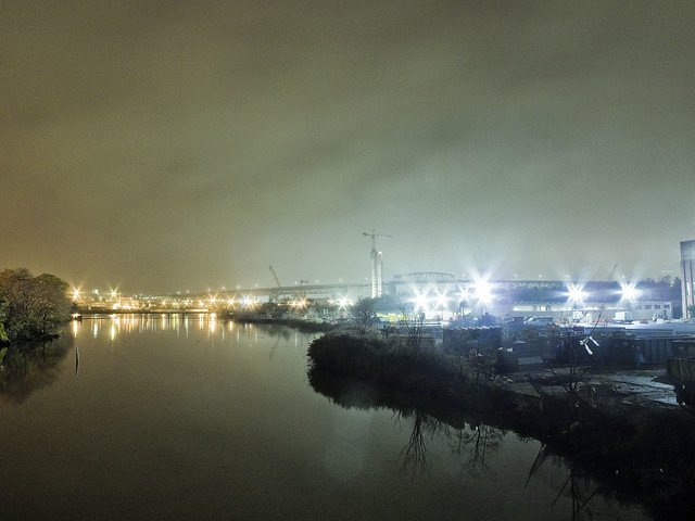
The shot above, depicting Newtown Creek’s tributary “Maspeth Creek” on a foggy night in November of 2015, was actually the first tripod shot which I popped off last Thursday.
I bagged the dslr momentarily, and employed my trusty old Canon G10 with its magnetic tripod and a remote shutter release. The magnet allows me to “clang” the camera onto fences, fire hydrants, anything ferrous. The shot is a 15 second long exposure, which characteristically causes water to assume a mirrored glass like appearance. In the distance – the Kosciusko Bridge, with Manhattan’s skyline lost in the mist rising from that malign example of municipal and corporate excess known only as the lugubrious Newtown Creek.
Tomorrow – more.
“follow” me on Twitter- @newtownpentacle


