Archive for 2016
tinkling flames
Finishing up a trip to Sheepshead Bay, in today’s post.

– photo by Mitch Waxman
Last week, I told you a bit about the NY Aquarium, and finding Nemo in Brighton Beach. Yesterday, it was a Holocaust Memorial, the Ocean Avenue footbridge, and an infestation of what I believe to be the mute swans in Sheepshead Bay. Today, we finish out my south east Brooklyn excursion and end with lunch at one of the old school businesses which has somehow survived the changing culture and real estate dynamics of Brooklyn.

– photo by Mitch Waxman
Sheepshead Bay has both a marina for small vessels and a series of Parks Dept. administered commercial piers along Emmons Avenue. There’s a plethora of fishing boats and pleasure craft on display at the marina.

– photo by Mitch Waxman
The commercial vessels, found along Emmons Avenue at the aforementioned commercial piers, range from gigantic to quite small. When I was a kid, these piers were occupied entirely by fishing boats. My next door neighbors owned one of them, called the “Atomic.”
Pictured above is the Atlantis excursion boat. Atlantis is technically a luxury yacht, designed for “functions,” and is spacious enough to serve a sit down dinner to 240 people or accommodate 319 for a party. She’s got a 32′ beam, is 147 feet long, and apparently there’s a jacuzzi with a lighted fountain onboard. She’s owned by an operation called “Amberjack” which has a flagship vessel that’s pretty huge and is docked right next door.

– photo by Mitch Waxman
These piers really seemed to be in great shape, and boy oh boy could we use this sort of shoreline tackle on the East River.

– photo by Mitch Waxman
Towards the other side of Sheepshead Bay’s fleet spectrum, that’s Capt. Midnight pictured above. She’s a 75 foot long fishing boat that can accommodate 63 guests.

– photo by Mitch Waxman
The western tip of the marina is visble from Emmons Avenue, and you can see what I mean about it being a pretty heterogenous collection of vessels.

– photo by Mitch Waxman
Pictured above is a bait shop which has been in this spot since I was a very young kid, nearly a half century ago.

– photo by Mitch Waxman
I spotted a pile of dead birds, which made for a nice picture, but a humble narrator was desperately in need of some luncheon and a cold drink at this point in time. Dead birds weren’t going to cut it.
Luckily…

– photo by Mitch Waxman
Roll N Roaster is still there, at the corner of Emmons and East 29th, just where I left it.

– photo by Mitch Waxman
And inside of RnR, nothing has changed since the 1980’s, except for the prices.

– photo by Mitch Waxman
I went with the lemonade, and the roast beef “as jus” sandwich. If you have the opportunity, get the above. If it’s wintertime, get the cheese fries as well. Fried potatoes just don’t go with the summer heat, IMHO.

– photo by Mitch Waxman
A short scuttle carried me over to Sheepshead Bay road, and the elevated tracks which carry the Q and B lines through the neighborhood. Around 45 minutes later, there I was, back in Astoria.
Upcoming Events and Tours
Wednesday, July 27, 1st trip – 4:50 p.m. 2nd trip – 6:50 p.m. –
2 Newtown Creek Boat Tours,
with Open House NY. Click here for more details.
Saturday, July 30, 11:00 a.m. – 1:00 p.m. –
DUPBO Walking Tour,
with Atlas Obscura. Click here for more details.
Sunday, August 21, 11:00 a.m. – 1:00 p.m. –
Poison Cauldron Walking Tour,
with Atlas Obscura. Click here for more details.
“follow” me on Twitter- @newtownpentacle
considerable distance
Back to southeast Brooklyn, in today’s post.

– photo by Mitch Waxman
Last week, I described taking a trip “back home” to the south eastern section of Brooklyn which spawned me. My ultimate goal for the trip involved a visit to the NY Aquarium, described in this post, and then I set off to the east in the direction of Brighton Beach where I seem to have found Nemo.
As mentioned in the two prior posts, having spent a good amount of time on the Q, or Brighton, line traveling here from Astoria in Queens – I wanted to maximize the time spent and decided to head over to Sheepshead Bay. At the head of the Bay, my first visit was to the Holocaust Memorial.
from nyc.gov
The park originally consisted of a grove of established London plane trees (destroyed by Hurricane Sandy in 2012 and since replanted) and a seating area which formed a contemplative space beside the water. After a lengthy planning process led by a local non-profit organization, the Holocaust Memorial Committee, Brooklyn Borough President Howard Golden allocated $933,000 toward construction of a permanent memorial designed and built by the City. Holocaust Memorial Park was dedicated on June 22, 1997 by Mayor Rudolph Giuliani.

– photo by Mitch Waxman
Having grown up in a Jewish neighborhood, and family, it was kind of normal to see people with non-ironic tattoos on their arms who were survivors of the Second World War’s death camps. In my peer group, it was actually fairly common for many of these folks to be my friend’s parents or grandparents.
Sheepshead Bay has, if anything, become even “more Jewish” in the years since I left this area, no doubt due to the huge number of Russian Jews who have emigrated here in recent decades. Accordingly, there’s a Holocaust Memorial Park at the head of the bay.
from wikipedia
The name “Sheepshead Bay” applies to the neighborhood north of the bay as well as the bay itself. Sheepshead Bay was named for the sheepshead, an edible fish found in the bay’s waters. The fish, now rare, can still be caught in the local waters occasionally.
The bay itself was originally the easterly entrance to Coney Island Creek, but the filling-in of the central part of this waterway during the 1930s, in conjunction with construction of the Shore Parkway portion of the Belt Parkway, eliminated access to that waterway. At the same time, the bay was widened, deepened, and bulkheaded at its western end. Recreational fishing fleets are now located there, though the fishing fleets have been shrinking every year and are being replaced by dinner boats. Holocaust Memorial Park, located at the western end of the bay, is used throughout the year for commemorative events.

– photo by Mitch Waxman
It’s actually a pretty nicely thought out sculptural installation that conveys a revenant vibe, and it is tellingly devoid of graffiti. Actually, one of the things I noticed about the modern version of Sheepshead Bay is that there was comparatively little graffiti on the walls. Even under the subway overpasses. This is a marked change from what it looked like when I was a kid. If the “old rules” of this section of Brooklyn still apply, it would indicate that there’s high ranking figures in the local underworld who have let the neighborhood know what will and will not be tolerated and that “street art” ain’t one of them.
When I was a kid, this figure would have been somebody of Italian ancestry, whereas today it is likely someone of Russian or Ukranian birth.

– photo by Mitch Waxman
I wasn’t at Sheepshead Bay to muse about the provence of the local Organized Crime families, nor to contemplate the Nazi regime and the consequences of their policies – instead I was here to revisit some of my old haunts and check out how the place was doing.
This neighborhood got absolutely slammed by Hurricane Sandy back in 2012, as you may or may not know,
from wikipedia
The western inlet of Coney Island Creek extends eastward from Gravesend Bay to Shell Road. The path of the landfill follows Shore Parkway, Guider Avenue, and the triangular block between Neptune Avenue and Cass Place. The eastern inlet picks up at Shore Boulevard and gradually widens into Sheepshead Bay.

– photo by Mitch Waxman
Sheepshead Bay was once part of the Coney Island Creek tidal strait – which seperated a sand bar barrier island – which today hosts the neighborhoods of Manhattan Beach, Brighton Beach, Coney Island, and Seagate – that was isolated from Brooklyn, which is actually on Long Island, and was called “Coney Island.” Coney was a proper island until Robert Moses came along in the 1950’s and turned it into a peninsula, separating Sheepshead Bay from the western section of Coney Island Creek with landfill, in pursuance of building out Shore Parkway and what we now call the Belt Parkway.
This section of the “House of Moses” is connected to the larger Jamaica Bay water system, which is absolutely teeming with all sorts of critters.
from wikipedia
Jamaica Bay is located on the southern side of Long Island, in the U.S. state of New York, near the island’s western end. The bay connects with Lower New York Bay to the west through Rockaway Inlet and is the westernmost of the coastal lagoons on the south shore of Long Island. Politically, it is divided between the boroughs of Brooklyn and Queens in New York City, with a small part touching Nassau County.

– photo by Mitch Waxman
Sheepshead Bay is fairly infested with Mute Swans. I believe they’re mute swans at least, (I’m no ornithologist) which are actually an invasive (anthropogenically introduced) specie native to Asia. You can tell what they are because of the orange bill. Trumpeter Swans, which are actually a native specie to North America, have black bills. They’re the Royal bird of the British Crown, which employs a “Royal Swanherd” to care for them on the Thames.
I didn’t see, nor have I ever heard of, anyone in Sheepshead Bay who might be described as a Swanherd.
from wikipedia
The English word ‘swan’, akin to the German Schwan, Dutch zwaan and Swedish svan, is derived from Indo-European root *swen (to sound, to sing). Young swans are known as swanlings or as cygnets; the latter derives via Old French cigne or cisne (diminutive suffix -et “little”) from the Latin word cygnus, a variant form of cycnus “swan”, itself from the Greek κύκνος kýknos, a word of the same meaning. An adult male is a cob, from Middle English cobbe (leader of a group); an adult female is a pen.

– photo by Mitch Waxman
The northern side of Sheepshead Bay follows Emmons Avenue, and that’s where you’ll find the big commercial docks as well as a series of restaurants, bars, and attractions. More on that in a minute, however.

– photo by Mitch Waxman
Shore Blvd. is on the tony Manhattan Beach side. Manhattan Beach hosts homes that are near mansions, and on its eastern tip you’ll find a nursing home and CUNY’s Kingsborough Community College. As an aside, when I was in high school back in the 1980’s, we referred to Kingsborough as the “12 and 1/2th grade” but I understand that they’ve really stepped up their academic standards since.
Connecting the two sides of the bay is the Ocean Avenue Bridge.

– photo by Mitch Waxman
Now, a bit of personal backstory is required for this.
My mother was terrified by many things. Elevators, African Americans, air conditioning, dogs, bees, flocks of passing birds – she was actually convinced that electricity could shoot out of the wall sockets if you didn’t put little plastic plugs in them. The largest resovoir of her irrational estimates of risk, however, always involved the water.
She would be rendered catatonic if she was around today and found out how much time I spend on boats, shorelines, etc. Catatonic, yes, but she would still likely be yelling at me about something.

– photo by Mitch Waxman
As a child, one thing I was forbidden to do by Mom – on pain of death – was to cross “dat piece a shit wooden bridge ovah dat Sheepshead Bay, it’ll collapse and they’ll never find ya body in that shit watah. Why woulds you do’s dat to me? Haven’t I sacrificed everyting for youse? Why would you do that to your mawtha?”
What can I say, the rumors you’ve heard about Jewish Mothers are actually kind of understated.
On the “pain of death” thing, for those of you under the age of thirty, it used to be pretty much assumed by kids that their parents possessed the legal right to murder them under the “I brought you into this world, I can take you out of it” rule.
from forgotten-ny.com
The bridge has a very old pedigree: it was first opened by Long Island Rail Road king Austin Corbin in 1880, and after a few false starts (Corbin kept closing the bridge since he thought “undesirables” would frequent his development, then-exclusive Manhattan Beach) there has been a pedestrian bridge here almost continuously since. It’s called the Ocean Avenue Bridge, even though it’s a block west of Ocean Avenue on the north side.

– photo by Mitch Waxman
It was with my last remaining ember of adolescent rebellion that I walked up the ramp to Ocean Avenue Bridge and headed across the water towards Emmons Avenue. Take that mom.

– photo by Mitch Waxman
Despite the spectral admonitions offered by a cranially contained inner voice which I refer to as “Mom,” I actually found the bridge to be in a fairly good state of repair. One did not fall into the water.

– photo by Mitch Waxman
Turning onto Emmons, I began to notice how much things had changed around Sheepshead Bay since the old days. Whole sections of the waterfront were completely changed, and most disturbingly, the bar I used to go to in high school that did not ask for proof of legal drinking age was gone. Of course, the bouncer at this particular bar – for a certain interval between 11th and 12th grade – was sometimes none other than Andrew Dice Clay.
That’s the neighborhood that I’m from, btw, for those of you know me in real life and think my behavior or speech patterns overly direct, confrontational, or not “politique” enough. As I often say, I grew up in “Brooklyn” Brooklyn where the only thing “artisanal” you might encounter was a beat down – if you were lucky enough to have encountered an assailant who was only using his hands rather than bricks, bats, or garbage can lids.

– photo by Mitch Waxman
Happily, though, some things on Emmons Avenue were exactly the same as they were the last time I was here, which reflection reveals as being more than two decades ago. More tomorrow.
Upcoming Events and Tours
Tuesday, July 26, 6:30 p.m. – 8:30 p.m. –
Glittering Realms Walking tour,
with NYC H2O. Click here for more details.
Wednesday, July 27, 1st trip – 4:50 p.m. 2nd trip – 6:50 p.m. –
2 Newtown Creek Boat Tours,
with Open House NY. Click here for more details.
Saturday, July 30, 11:00 a.m. – 1:00 p.m. –
DUPBO Walking Tour,
with Atlas Obscura. Click here for more details.
Sunday, August 21, 11:00 a.m. – 1:00 p.m. –
Poison Cauldron Walking Tour,
with Atlas Obscura. Click here for more details.
“follow” me on Twitter- @newtownpentacle
following day
puzzling things, general weirdness, and an update on that transformer fire in Astoria.

– photo by Mitch Waxman
Out on the water in NY Harbor recently, the scene above was observed.
Famously, one of those “harbor advocacy” statements which one is oft heard announcing on my walking and boat tours is that “maritime is the greenest way to transport cargo, with a single barge carrying the equivalent of thirty eight trucks worth of stuff,” but you seldom see it literally expressed by a barge carrying an actual truck. My rhetorical statement is actually built around a full sized flat top barge carrying cargo containers and guided by harbor sized tugboat type of scenario, rather than a smallish work barge that’s carrying a dump truck and being towed by a little push boat.
The push boat is the TJ Miller, btw, which operates of Staten Island’s Millers Landing.

– photo by Mitch Waxman
Passing by the Fuller Brush, or Flatiron building if you must, recently – I couldn’t get the whole 23 Skidoo stuff to exit my brain. I went to college a few blocks away at the School of Visual Arts, and Manhattan’s 23rd street was – and remains – one of the main thoroughfares of my life. Post college, most of the advertising agencies which I worked for were located somewhere within a few blocks of the Flatiron for some reason. I seldom photograph along its route, however, as the School of Visual Arts is – as mentioned – just down the block. They have a world class photography program there, and the 23rd street corridor is probably one of the most “captured” spots on the planet. While I was at SVA, I was in the illustration program, so unfortunately I haven’t got much in the way of documentation of the 1980’s version of it as I was drawing comics and painting and stuff back then.
It makes me wonder, however. Taking the Flatiron as an example, which is one of the most photographed buildings in NYC, and has been for a century… one ponders what information about our environment could be gleaned from assembling the decades long recordings of its appearance. Weather patterns, erosion, particulate levels in the air?

– photo by Mitch Waxman
Back in Astoria, after that transformer explosion I described to you a couple of weeks ago, it took the Con Ed guys about three days – working 24 hours, mind you – to put things back in order. There’s still crews working around two to three blocks north and to south, as presumptively wherever the wires connected to that failed equipment led to must have been also been damaged or affected by the event. That’s my guess anyway.

– photo by Mitch Waxman
It took the Con Ed crews just under a day to get the blacked out block of 44th street between 34 avenue and Broadway back on the grid, but that’s when their real job began. I don’t know too much about their operation, but I can describe how it played out. First there were emergency crews who arrived in red trucks who “put out the fire.” They were followed by a far larger contingent of blue truck crews who arrived with a variety of equipment and what seemed like a third party contractor. As the project went on, the cable trucks arrived, one of which is in the shots above.

– photo by Mitch Waxman
The (seemingly) third party contractor got busy digging up a pretty sizable trench leading from the transformer and following the curbline. The blue truck guys were moving in and out the manholes and had a substantial amount of equipment deployed. They were all working during the sweltering July heat, incidentally.
About three days after the transformer fire, they all suddenly left.

– photo by Mitch Waxman
Just another blackout in Astoria, Queens, I guess.
Upcoming Events and Tours
Tuesday, July 26, 6:30 p.m. – 8:30 p.m. –
Glittering Realms Walking tour,
with NYC H2O. Click here for more details.
Wednesday, July 27, 1st trip – 4:50 p.m. 2nd trip – 6:50 p.m. –
2 Newtown Creek Boat Tours,
with Open House NY. Click here for more details.
Saturday, July 30, 11:00 a.m. – 1:00 p.m. –
DUPBO Walking Tour,
with Atlas Obscura. Click here for more details.
Sunday, August 21, 11:00 a.m. – 1:00 p.m. –
Poison Cauldron Walking Tour,
with Atlas Obscura. Click here for more details.
“follow” me on Twitter- @newtownpentacle
small item
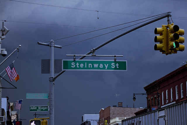
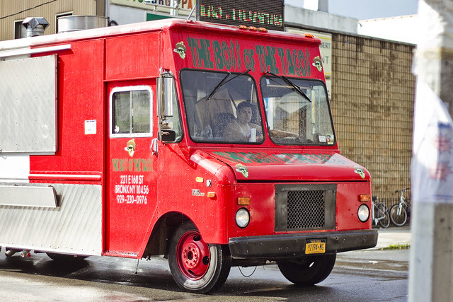
Thunderstorm action, and the Boss of The Tacos, in Astoria, Queens.
– photo by Mitch Waxman
You might recall that on the afternoon of Thursday, the 14th of July, a crazy powerful thunderstorm washed through the City. It happened that one was out and about, running errands, and as always I had my camera with me when the skies grew dark. What was weird about this storm was that it presented a nearly vertical line, and that to the east – skies were blue and the sun shining.
This created some VERY interesting lighting effects.

– photo by Mitch Waxman
The whole neighborhood here in Astoria knew that there was a deluge coming, and everybody was scurrying around trying to accomplish one last thing before sheltering from the coming storm. Personally, knowing that I’d never get back to HQ before the rain hit, a quick visit to my local bar allowed me a bit of cover and had the corollary benefit of allowing a pint of beer to be poured in.

– photo by Mitch Waxman
The rain blew in along a wall shaped vector, and the air was suddenly filled with what had to be hundreds of thousands of gallons of water in a few seconds. As is typical of thunderstorms, however, the event only lasted for around twenty minutes or so. That’s about how long it took me to quaff my pint of beer.
– photo by Mitch Waxman
As there is no better moment, air quality wise, in NYC than the half hour or so following a storm like this, I decided to order a second pint and settle alongside a familiar table outside. That’s when this enigmatic food truck rolled by, which was emblazoned with a screed reading “The Boss of The Tacos.”
There is a reason, after all, that I carry a camera with me everywhere I go. Astoria Queens rules.
Upcoming Events and Tours
Saturday, July 23, 11:00 a.m. – 1:00 p.m. –
Calvary Cemetery Walking tour,
with Brooklyn Brainery. Click here for more details.
Cancelled due to extreme weather, will be rescheduled.
Tuesday, July 26, 6:30 p.m. – 8:30 p.m. –
Glittering Realms Walking tour,
with NYC H2O. Click here for more details.
Wednesday, July 27, 1st trip – 4:50 p.m. 2nd trip – 6:50 p.m. –
2 Newtown Creek Boat Tours,
with Open House NY. Click here for more details.
Saturday, July 30, 11:00 a.m. – 1:00 p.m. –
DUPBO Walking Tour,
with Atlas Obscura. Click here for more details.
Sunday, August 21, 11:00 a.m. – 1:00 p.m. –
Poison Cauldron Walking Tour,
with Atlas Obscura. Click here for more details.
“follow” me on Twitter- @newtownpentacle
intact copy
A short aside on the Arthur Kill, and a look at the Goethals Bridge project.

– photo by Mitch Waxman
For the last few days, I’ve been describing a day trip to South East Brooklyn, which we’ll return to later on, but for today’s post I want to show you what’s going on at the veritable edge of NYC on the western end of… Staten Island… at the Arthur Kill waterway. That’s the Goethals Bridge construction project you’re looking at, which is another one of the three mega projects involving bridges going on in NYC at the moment.
I was actually “at work” when these shots were captured, conducting a corporate boat excursion for a group that wanted to “see something different” than what you normally get on a harbor cruise. They were all eating lunch on another deck as we passed by the Goethals so I grabbed my camera and got busy.

– photo by Mitch Waxman
I’m nowhere near as familiar with Goethals as I am with the Kosciuszcko Bridge over my beloved Newtown Creek, of course, but I can tell you that the span overflying the water is 672 feet long. With its approaches, which connect Elizabeth, New Jersey (and the NJ Turnpike) to… Staten Island… the structure is actually some 7,109 feet long. It’s 62 feet wide, 135 feet over the Arthur Kill, and carries about 80,000 vehicles a day.
Goethals opened in June of 1928, and along with the nearby Outerbridge Crossing, was the inaugural project for a newly created organization known to modernity as the Port Authority of New and New Jersey.

– photo by Mitch Waxman
Like several of the depression era bridges in NYC, Goethals has been deemed as being insufficient for the amount of traffic it carries, and it has developed some structural issues over the last century. Port Authority is building a replacement bridge, which will be a cable stay type span. It’s going to be wider, have modern traffic lanes, and incorporate both bicycle and pedestrian access into its design. It’s also meant to be a “smart bridge” which will utilize active sensor technologies to monitor traffic and structural integrity.
The PANYNJ has also left room in their designs for future modifications to the span like adding a rapid transit line. The blue bridge you see just north east of the Goethals is a railroad lift bridge which connects New Jersey’s CSX rail lines to the New York Container Terminal port facility on the… Staten Island… side. It’s called the “Arthur Kill Vertical Lift Railroad Bridge,” for the curious.
The part of… Staten Island… where all this is happening is called “Howland Hook.”

– photo by Mitch Waxman
That’s the Elizabeth, New Jersey side, where the Goethals connects to New Jersey’s “Chemical Coast.” It’s called that for the enormous presence of the petroleum industry in Elizabeth. This area was formerly the property of the Standard Oil Company of New Jersey.
SOCONJ retained the corporate branding of the Standard Oil trust after the Sherman anti trust act was invoked by President Teddy Roosevelt back in 1911. That branding was “S.O.,” which over the course of the 20th century first became “ESSO” and then later became “EXXON.”

– photo by Mitch Waxman
The new Goethals Bridge is meant to be ready for use in 2018, at which point the PANYNJ will begin the demolition project to get rid of the original. The 1928 steel truss cantilever bridge was designed by a fellow named John Alexander Low Waddell, who also designed the nearby Outerbridge Crossing. As a note, Outerbridge Crossing is not called that due to it being the furthest out bridge, as colloquially believed. It’s named for a a guy named Eugenius Harvey Outerbridge, and I’m friends with his grandson Tom.
The Goethals Bridge(s) is named for General George Washington Goethals, superviser of construction for the Panama Canal, and first consulting engineer of the Port Authority of New and New Jersey.
The PANYNJ has a neat website set up for the project which includes live construction webcams, check it out here.
Upcoming Events and Tours
Saturday, July 23, 11:00 a.m. – 1:00 p.m. –
Calvary Cemetery Walking tour,
with Brooklyn Brainery. Click here for more details.
Tuesday, July 26, 6:30 p.m. – 8:30 p.m. –
Glittering Realms Walking tour,
with NYC H2O. Click here for more details.
Wednesday, July 27, 1st trip – 4:50 p.m. 2nd trip – 6:50 p.m. –
2 Newtown Creek Boat Tours,
with Open House NY. Click here for more details.
Saturday, July 30, 11:00 a.m. – 1:00 p.m. –
DUPBO Walking Tour,
with Atlas Obscura. Click here for more details.
Sunday, August 21, 11:00 a.m. – 1:00 p.m. –
Poison Cauldron Walking Tour,
with Atlas Obscura. Click here for more details.
“follow” me on Twitter- @newtownpentacle


