contraband nature
It’s National Jelly Donut Day, in these United States.

– photo by Mitch Waxman
One has been on a non stop run across the City of Greater New York for the last six weeks, and my dogs are barking. Haven’t been to Staten Island (except by water, twice) or the Bronx at all, but tomorrow I’m going to Plumb Beach nearby Sheepshead Bay to attend a lecture on Horseshoe Crabs which, as it turns out, is being led by my tenth grade biology teacher. Small world, big City, I guess. The shot above was captured at the Grand Avenue station in Elmhurst, where I’ve been three times in the last six weeks, but was just passing through.

– photo by Mitch Waxman
The shot above was gathered onboard the new Citywide Ferry Rockaway service, which left from Pier 11 in Manhattan and proceeded to Bay 108 in Rockaway in about fifty minutes with a stop in Sunset Park. I was puzzled as to the end goal destination, across the street from the DEP’s Rockaway waste water treatment plant. B 108 isn’t exactly “Main Street” if you know what I mean, but putting two and two together, I figure that the City probably owns the land there due to the Rockaway Plant’s long tenancy and it was likely the only affordable spot along the Rockaway waterfront where you could install the dock.
Pictured, of course, is a NY Water Taxi rather than a Citywide Ferry boat. The Water Taxi was exiting Erie Basin while performing part of its’ IKEA ferry route.
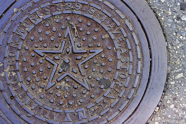
– photo by Mitch Waxman
Wandering around Astoria one recent day, this coal chute cover was encountered and I decided to do a bit of detective work on the address embossed into its legend. The folks at Greater Astoria Historic Society host a page which describes the various name changes that the streets in Astoria have assumed over the years, which provided for some of the hard slog footwork in translating “329 9th Ave., Astoria, L.I.” into the modern day street grid.
What was once known as “Kowenhoven St.” in a city of Newtown called Astoria, which was later renamed as “9th avenue by the independent municipality of Long Island City, became 38th street in the Borough of Queens and a part of the Consolidated City of Greater New York in the early 20th century. The sections of Belcher Hyde Fire Insurance Maps included in today’s post date from 1919, and still carry the LIC era street names and addresses.

– Belcher Hyde map 1919
Broadway is always so named, and Steinway Street was once an avenue but is still named after the local Piano Baron, and 31st avenue used to be called first Jamaica and then Patterson Avenue. 9th street is now 38th street, and if I’m reading the map correctly, the street address (329) of the Atlantic Iron Works would correspond with that of the no longer extant Public School no. 6 (which is a whole other story) and is coterminous with the modern day “Sean’s Place” playground.

– Belcher Hyde map 1919
As a note, the track lines indicated are Trolley, or Streetcar tracks. The arrival of the IND subway line was still a few years away at the stage of the game, and the “cut and cover” work was likely underway but not indicated.
“follow” me on Twitter- @newtownpentacle


Leave a comment