Posts Tagged ‘hatch’
sequestered factoids
I miss the tick tock of analogue clocks.

– photo by Mitch Waxman
I’m a bit behind schedule today, as I had to got to Greenpoint to do a lecture for a group of school teachers about my beloved Creek, and that’s why a single image greets you. Back tomorrow with a story that’s just plain bats.
Tours and Events
Canal to Coast: Reuniting the Waters Boat Tour. Only $5!
Thurs, August 30, 2018, 6:30 PM – 8:30 PM with Waterfront Alliance
Learn about the origins of Brooklyn’s Erie Basin as the Erie Canal’s ultimate destination, and its current role as a vital resource for maritime industry on this guided tour of Red Hook’s Erie Basin and the Brooklyn working waterfront, departing from and returning to New York Water Taxi’s Red Hook Dock. Tickets here.
“follow” me on Twitter- @newtownpentacle
contraband nature
It’s National Jelly Donut Day, in these United States.

– photo by Mitch Waxman
One has been on a non stop run across the City of Greater New York for the last six weeks, and my dogs are barking. Haven’t been to Staten Island (except by water, twice) or the Bronx at all, but tomorrow I’m going to Plumb Beach nearby Sheepshead Bay to attend a lecture on Horseshoe Crabs which, as it turns out, is being led by my tenth grade biology teacher. Small world, big City, I guess. The shot above was captured at the Grand Avenue station in Elmhurst, where I’ve been three times in the last six weeks, but was just passing through.

– photo by Mitch Waxman
The shot above was gathered onboard the new Citywide Ferry Rockaway service, which left from Pier 11 in Manhattan and proceeded to Bay 108 in Rockaway in about fifty minutes with a stop in Sunset Park. I was puzzled as to the end goal destination, across the street from the DEP’s Rockaway waste water treatment plant. B 108 isn’t exactly “Main Street” if you know what I mean, but putting two and two together, I figure that the City probably owns the land there due to the Rockaway Plant’s long tenancy and it was likely the only affordable spot along the Rockaway waterfront where you could install the dock.
Pictured, of course, is a NY Water Taxi rather than a Citywide Ferry boat. The Water Taxi was exiting Erie Basin while performing part of its’ IKEA ferry route.
– photo by Mitch Waxman
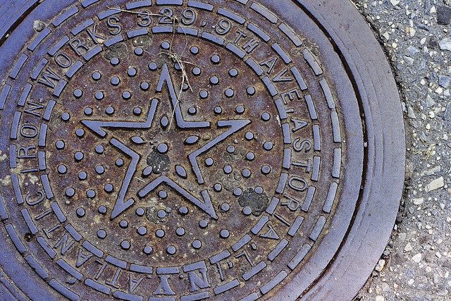
Wandering around Astoria one recent day, this coal chute cover was encountered and I decided to do a bit of detective work on the address embossed into its legend. The folks at Greater Astoria Historic Society host a page which describes the various name changes that the streets in Astoria have assumed over the years, which provided for some of the hard slog footwork in translating “329 9th Ave., Astoria, L.I.” into the modern day street grid.
What was once known as “Kowenhoven St.” in a city of Newtown called Astoria, which was later renamed as “9th avenue by the independent municipality of Long Island City, became 38th street in the Borough of Queens and a part of the Consolidated City of Greater New York in the early 20th century. The sections of Belcher Hyde Fire Insurance Maps included in today’s post date from 1919, and still carry the LIC era street names and addresses.

– Belcher Hyde map 1919
Broadway is always so named, and Steinway Street was once an avenue but is still named after the local Piano Baron, and 31st avenue used to be called first Jamaica and then Patterson Avenue. 9th street is now 38th street, and if I’m reading the map correctly, the street address (329) of the Atlantic Iron Works would correspond with that of the no longer extant Public School no. 6 (which is a whole other story) and is coterminous with the modern day “Sean’s Place” playground.

– Belcher Hyde map 1919
As a note, the track lines indicated are Trolley, or Streetcar tracks. The arrival of the IND subway line was still a few years away at the stage of the game, and the “cut and cover” work was likely underway but not indicated.
“follow” me on Twitter- @newtownpentacle
alienist harmony
It’s World Day of Social Justice, for member states of the United Nations.

– photo by Mitch Waxman
Just a quickly today, as it’s also a holiday and I’m taking the day off. That’s a gas main hatch spotted somewhere over in Brooklyn, nearby the Newtown Creek.
“follow” me on Twitter- @newtownpentacle
hysterical laughter
It’s Edgar Allen Poe’s Birthday, Icelandic Man’s and Woman’s Day (Bóndadagur), and it’s also National Popcorn Day – here in these United States.

– photo by Mitch Waxman
Part of my scheme to survive the cold this year involves a bit of a mix up on the normal routine. Rather than walk from Point A in Astoria to some distant industrial wasteland and then follow a completely different path back home (my normal “thing”), I’ve instead been taking the subway out a few stops to spots around three to four miles from home and then figuring out how to walk back home along an interesting route. On a recent day, my route involved taking the G out to Williamsburg. Not the shiny part of Williamsburg, of course, but the still crappy section that touches southern Greenpoint.
Whenever I’m in Williamsburg, I stare at the ground lest I catch the eye of a hipster who might find me novel or twee.

– photo by Mitch Waxman
On the corner of Metropolitan Avenue and Leonard Street, this centuried access cover was encountered, bearing the screed “Catskill Water Chamber.” Now, I’ve asked the question “who can guess, all there is, that might be buried down there?” more than once at this – your Newtown Pentacle over the years… but in this case I don’t actually have to guess or wonder.
This is the sort of stuff that I know about which makes the folks at NYC DEP nervous about how I know it, incidentally. Short answer – while everybody else is reading about celebrity news or watching sports, I’m combing through the well hidden corners of NYC.gov. It’s a gold mine, I tell you.
Water Tunnel #2 is about 17 feet in diameter, and it feeds pipes which first stretch out under Long Island City, Greenpoint, and Williamsburg. A sixty inch trunk main pipe under Jackson Avenue in LIC connects to one on McGuinness Blvd. in Greenpoint after passing under the Newtown Creek. At Leonard Street and McGuinness, a seventy two inch pipe is connected to the main line, and that one feeds water all the way to Driggs Avenue.
At the corner of Metropolitan Avenue and Leonard Street here in Williamsburg, where the access cover seen above can be found, there’s a series of smaller twelve inch mains which split off from the main flow and feed water to local customers.

– photo by Mitch Waxman
It’s likely that these access covers were forged sometime between 1905 and 1915, with the Catskill system beginning to come online in late 1915. The Catskill system was ultimately completed by 1928, forging one leg of the tripod of upstate reservoirs which supply NYC with drinkable water. It’s all very complicated.
The NYC Department of Water Supply, Gas and Electricity was the entity which the Catskill system would be handed over to, and was one of the many “wet work” agencies that were compressed into the gargantuan NYC Department of Environmental Protection back during the City Charter revision of 1983.

– photo by Mitch Waxman
After congratulating myself on displaying another bit of my largely useless knowledge base, it was time to start moving again as a small crowd of hipsters were beginning to form and I feared ending up being posted about on Instagram again. One decided to continue up Metropolitan Avenue, following it to the Northeast, and inexorably approaching those loathsome existential realities which one finds lurking about the legendary Newtown Creek.
More tomorrow – at this, your Newtown Pentacle.
“follow” me on Twitter- @newtownpentacle
overtones of
Another random series of shots, in today’s post.

– photo by Mitch Waxman
Over in Greenpoint, a line of empty taxis parked on Provost Street, across the street from the sewer plant.
It’s actually meant to be pronounced as “Provoost” despite being spelled as “Provost.” The Provosts were one of the original five families of Greenpoint, along with the Bennets, Calyers, Praas, and Messeroles. These five Dutch families dominated Greenpoint politically for nearly two centuries, owned most of the land, and only began to recede into history when Neziah Bliss married into the Messerole clan. Bliss laid out the modern street grid, erected the first bridges over Bushwick and Newtown Creeks, and is the father of the modern community.

– photo by Mitch Waxman
The IND R train entering into Queens Plaza. Queens Plaza’s IND service opened for business on August 19th in 1933, but back then there was only express service between Manhattan and Queens. It wasn’t until 1955 when the 60th street tunnel opened that the Queens local trains began to travel back and forth into the Shining City. I work on getting this shot every time I’m there, and you have to time it just right to catch an arc flash that the train sets off as it comes to the station tracks grade.

– photo by Mitch Waxman
It’s amazing how many manhole cover types there are, a subject which has been discussed endlessly at this – your Newtown Pentacle. The story of municipal consolidation can be read in the screeds embossed onto these iron discs, and the one pictured above was once the property of the “Bureau of Water and Sewers” which is now part of the NYC DEP and can be observed at the border of Sunnyside and Blissville in Queens.

– photo by Mitch Waxman
This is a “Brooklyn Department of City Works” access cover, which was found back in Greenpoint. DCW is also now a part of the consolidated DEP.
– photo by Mitch Waxman
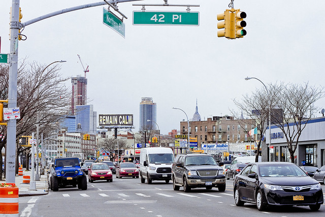
Back in Queens, on the “carridor” of Northern Blvd., a puzzling bit of signage has emerged on one of the enormous advertising bill boards found on the corner of 38th street. The easterly facing side says “Stay Calm” with a screed reading “-Peter.”

– photo by Mitch Waxman
The westerly facing side says “Don’t Panic,” and also has the “-Peter” signature. Dictionary definitions are superimposed on the block print messaging, this one bears the definition of courage. I’ve looked around for what these signs are meant to be selling or saying, but haven’t been able to find out much. If anybody knows what’s up with these messages, please share in the comments.
Either way, they are reminiscent of the sort of things Rowdy Roddy Piper observed in the John Carpenter film “They Live.”

– photo by Mitch Waxman
A gorgeous bit of hand painted signage adorns the back of a NYCHA emergency truck back in Greenpoint, and is pictured above.
“follow” me on Twitter- @newtownpentacle


