some curse
Twirling, ever twirling.
– photo by Mitch Waxman
From HQ in Astoria, I’ve got several approach vectors to the various sections surrounding the Newtown Creek. Walking south on 39th street and making a right on Skillman Avenue takes me to Dutch Kills in LIC, for instance. 43rd street carries me across Sunnyside and towards the Kosciuszcko Bridge. South on 48th street will point my toes at Maspeth Creek and or the Grand Street Bridge. In all the cases above, one walks downhill out of Astoria to cross a low point at Northern Blvd. and then up a shallow hill and the ridge which Sunnyside sits on. After crossing a certain point, the declination of the land begins to slope back down towards the flood plains surrounding Newtown Creek.
Then there’s the Woodside Avenue/58th street path, which is what I call “good cardio.” What makes it good is that you are pretty much pulling up hill towards the Maspeth Plateau the entire way. On this path, you get to stop and consider the place marker on 58th street and Queens Blvd. installed by the Dept. of City Planning denoting the geographic center of NYC, walk along the walls of Calvary Cemetery’s second and third divisions, and dodge a lot of traffic. Fun.

– photo by Mitch Waxman
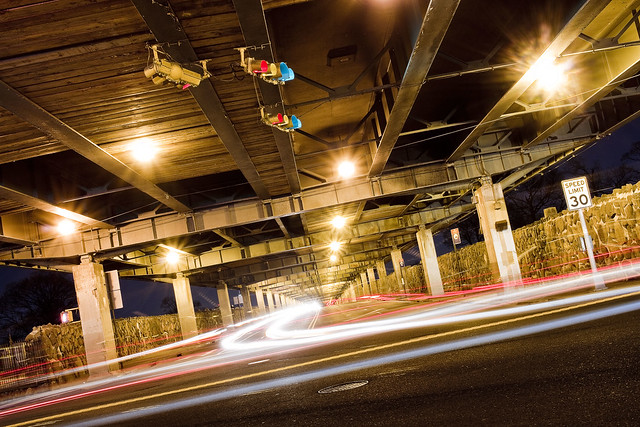
Theoretically, the street pictured above is Laurel Hill Blvd., which is overflown by the Brooklyn Queens Expressway on an elevated ramp. Calvary 2 is on the north side of the street, Calvary 3 on the south. Both sections of the funerary complex sport high masonry walls which are somewhat oppressive, and are oddly free of graffiti. My understanding is that there is a street racing scene hereabouts on Laurel Hill Blvd., but I’ve never observed it. Recent experience has revealed that the fast and furious crowd currently prefers Review Avenue in Blissville, nearby Calvary 1, for their antics. To the North and East is the Woodside section, West and North is Sunnyside, and heading South brings you to Maspeth.
Oddly enough, this section of road is terrifically well travelled, even at night. It seems to be a bit of a shortcut for drivers, and the Q39 bus enjoys a couple of stops down here. As mentioned from a post a couple of weeks back, the State controlled highway which the street lamps are mounted on has not switched over to LED luminaires as the City has and old school sodium lights offer a now nostalgic orange glow.
– photo by Mitch Waxman
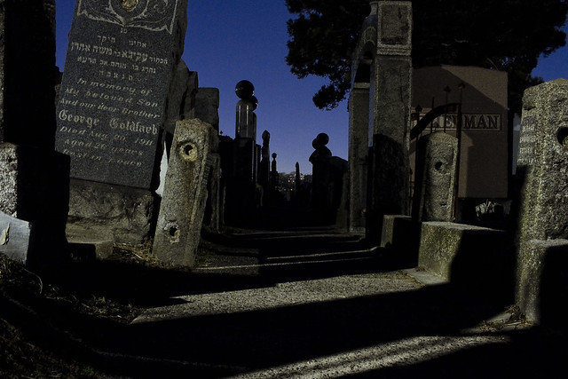
58th street itself, between the BQE and the Long Island Expressway, is essentially a trench running between two cemeteries – the aforementioned Calvary properties to the west and Mt. Zion to the East. Truly terrifying for a pedestrian, what passes for sidewalks are essentially earthen berms piles up against the cemetery walls.
Not everybody walks past a cemetery fence at night wishing that the property was open 24 hours, and regretful that the photographic splendors therein are out of reach, but I do. One couldn’t resist getting a few shots through the fence of Mt. Zion while picking my way along the rough hewn berm. Oh, to gain purchase within and spend time with the night gaunts and tomb legions.
“follow” me on Twitter- @newtownpentacle
Buy a book!
“In the Shadows at Newtown Creek,” an 88 page softcover 8.5×11 magazine format photo book by Mitch Waxman, is now on sale at blurb.com for $30.


Why are the graves socloselypackedtogether at Mt. Zion, but m u c h m o r e e x p a n s I v e at Calvary?
georgetheatheist . . . momento mori
February 25, 2020 at 2:49 pm
One in a grave for jews, Catholics allow stacking. Really.
Mitch Waxman
February 25, 2020 at 4:11 pm
“Oh, to gain purchase within and spend time with the night gaunts and tomb legions.”
Stop by Bayside/Acacia cemetery. Plenty of ways in and the security quite lax. Not a very exciting crowd there unlike 1st Calvary which is always a hoot but if easy is what you want…
Cav
February 25, 2020 at 7:12 pm
Mr, Waxman…..Your articles, photographs and presentation are a virtual TREASURE! I’ve spent much of my working career in the area with 45 years in the Engineering Department of a Heavy Local Contractor.
I’ve worked on many of the projects that You illustrate. Is it a coincidence that the nostalgia that You bring to life plays like a ‘life history’ lesson to me? I even have my Parents reposing in Calvary Cemetery. Our latest project (before my retirement in May, ’17) saw the completion and opening of the 1st new Kosciusko Bridge and the demolition of the existing one.
Your photos of the ins-and-outs of the surrounding neighborhoods and infrastructure are missing pieces of the puzzle that I’ve wondered about for years. I’ve had the honor to be involved with the infrastructure which You write about. This includes the Newtown Creek WPCP, The Long Island Expressway, BQE, LIRR Shops and Yards, The Archer Avenue (and other) Subways, the #7 Line El and Woodside Station. It’s been a “Lot of water under the bridge, and a lot of bridges over the water”. We’ve done the Dept. of Sanitation Transfer Station on the East River…..the list goes on and on, and includes the Thompson and Hunters Point Avenue Bridges over Sunnyside Yard. I remember as a child, waving to the people on the Trolley Cars on the Queensborough Bridge. Little did I know that I would be producing drawings for the Hudson-Bergen Light Rail and the ‘Air-Train’ to Kennedy Airport decades later.
Your photos of the Bascule Bridges recall ‘familiar territory’, as I worked as a Structural Inspector for Movable Bridges, climbing in, around and through such structures. It is a shame that the litter which You mention is such a blight to this city. I was amazed in Vienna, Austria where the subways were so clean that one thought that the Trackbed was a freshly-swept sidewalk. When will we learn?
I am privileged to be a member of Your site …..You have a Magnificent way of writing. Please keep up your excellent work.
Thank You…..
Bobby Bridgeman
bobbybridgeman
February 29, 2020 at 12:07 am