Author Archive
St. Pat’s day for all Parade
Another gargantuan set of photos can be found at flickr, this time from the St. Pat’s Day for all parade in Sunnyside on March 7, 2010. Here’s a few shots for now, as I’m in a bit of a hurry this morning, but we’ve got to talk about the protesters later on- VERRRY Interesting…

Malachy McCourt and Daniel Dromm – photo by Mitch Waxman

Brendan Fay and John Liu – photo by Mitch Waxman

Irish Traditional Dance – photo by Mitch Waxman

Joseph Crowley – photo by Mitch Waxman

Christine Quinn and Michael R. Bloomberg – photo by Mitch Waxman

Just how tall is Bill de Blasio, anyway? – photo by Mitch Waxman

Christine Quinn and Moppet – photo by Mitch Waxman

A great dog – photo by Mitch Waxman

Protester – photo by Mitch Waxman
I’ll be talking about these folks in some depth in a post this evening, which you will not want to miss (come into my house, from a Brazilian right wing cult, and think that the Newtown Pentacle won’t notice- HA). In the meanwhile, the entire photoset is up at flickr, and can be accessed by clicking here.
Lots of politicians and dignitaries, and if you attended, I swept the crowd a few times. Here’s a link to the whole shebang in a slideshow.
exhausted
Phew. Busy couple of days… sorry for the lack of contact. Creek week is extending into next week as well, but check out what I did on Friday the 5th.
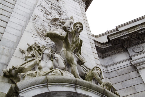
– photo by Mitch Waxman
On Friday, I attended a ceremony which placed a time capsule in the Manhattan Bridge, then walked from Chinatown to Astoria, developed a LOT of photos, slept 4 hours.
Saturday- woke up, took a ride on the Staten Island Ferry, then walked part of the Kill Van Kull shoreline , visited my sick mom in the hospital, and came back to Astoria.
Tomorrow is the “St. Pat’s Day for All” parade in Sunnyside- which promises to be enjoyable AND photogenic- if you’re around the neighborhood- don’t miss it.
Now, here’s a few shots from the Manhattan Bridge event.

DOT Commissioner Janette Sadik-Khan – photo by Mitch Waxman
from nyc.gov
Janette Sadik-Khan serves as the Commissioner of the New York City Department of Transportation since her appointment by Mayor Michael R. Bloomberg in April of 2007. She manages 4,500 skilled employees with wide ranging expertise from engineering to construction finance, to marine navigation, and is responsible for 6,000 miles of streets and highways, nearly 800 bridges, 1.3 million street signs, 300,000 streetlights and 12,000 signalized intersections, as well as the Staten Island Ferry, the nation’s busiest commuter ferry service carrying over 19 million passengers annually.
Since her appointment, Sadik-Khan has implemented an ambitious program to improve safety, mobility and sustainability throughout New York City, and ensure a state of good repair on all the Department’s roads and bridges. In April 2008 the Agency published its Strategic Plan, Sustainable Streets. Projects highlighted in that plan include the first Select Bus routes for NYC, the NYC Plaza Program, the creation of Broadway Boulevard in midtown Manhattan, the addition of 200 miles of on-street bike lanes, car-free summer streets and weekend pedestrian walks.

“Gridlock Sam” Schwartz – photo by Mitch Waxman
from gridlocksam.com
From 1982-86, Sam Schwartz served an extremely successful term as New York City’s Traffic Commissioner before going on to serve the next four years as the New York City Department of Transportation’s Chief Engineer/First Deputy Commissioner.
After nearly twenty years with the New York City Department of Transportation, Mr. Schwartz moved from public service in 1990 to join Hayden-Wegman Consulting Engineers, Inc. as Senior Vice President in charge of transportation engineering, infrastructure, quality control and planning.
In the summer of 1995, The Sam Schwartz Engineering opened its doors with a staff of two. Since that time, the company has grown to include over sixty diverse professionals. Today, under Sam’s direction, The Sam Schwartz Engineering produces some of the finest work in civil engineering, planning, and urban design.

Henry Perahia, Deputy Commissioner Chief Bridge Officer DOT – photo by Mitch Waxman
from nyc.gov
In 1998 Mr. Perahia was promoted to Chief Engineer of the Department. In 1999, he was given the added responsibilities of Chief Bridge Officer. As Chief Engineer, he serves as the Department’s representative on all engineering issues, including review of all major Department projects, response to engineering emergencies, and advising the Commissioner on all engineering issues. As Chief Bridge Officer, he is responsible for the planning and administration of all aspects of design, construction and maintenance of approximately 750 City-owned bridges, tunnels, and culverts, with an annual capital program of approximately $500 million and an annual expense budget of approximately $56 million.
The Division of Bridges is responsible for maintaining the structural integrity of all City owned bridges and tunnels. It undertakes the design and construction of all rehabilitation and reconstruction work, including in-house design, engineering support, engineering review, and quality assurance. It inspects the City’s bridges to identify hazardous or potentially hazardous.

A few of the items that were placed in the Time Capsule – photo by Mitch Waxman

The assembled crowd of dignitaries, DOT workers, and invited well wishers – photo by Mitch Waxman

The time capsule was sealed up within the ornate arches of the Bridge – photo by Mitch Waxman

Specifically, right about here (this is inside the arch) – photo by Mitch Waxman

How could I not have a look around? I mean, how often are you inside the Manhattan Bridge, after all? – photo by Mitch Waxman

A window? – photo by Mitch Waxman

Here’s the view from said window – photo by Mitch Waxman
for the complete set of photos at flickr- click here
the hillside thickets
CREEK WEEK continues…
- For the first installment, from the mouth of the Newtown Creek at the East River to the Pulaski Bridge, click here. For more on just the Pulaski Bridge, click here.
- For the second installment, which turns off the main course of the Newtown Creek and follows the Dutch Kills tributary to Long Island City’s Degnon Terminal, click here.

– photo by Mitch Waxman (from the Queens Museum of Art’s “Panorama of the City of New York”)
As the Newtown Creek follows its atavist path across the (currently) undefended border of Brooklyn and Queens, the second drawbridge encountered along its length is the J.J. Byrne Memorial Bridge, aka the Greenpoint Avenue Bridge, which provides a connection between Queen’s Blissville and Brooklyn’s Greenpoint.
A detailed posting on this bridge and its immediate environs was presented in August of 2009, which can accessed by clicking here.
from the DOT website:
The Greenpoint Avenue Bridge is a double-leaf trunnion bascule, with 21.3m wide leaves. This bridge is a steel girder structure with a filled grid deck. The bridge provides a channel with a horizontal clearance of 45.4m and in the closed position a vertical clearance of 7.9m at MHW and 9.4m at MLW. The bridge structure carries a four-lane two-way vehicular roadway with a 1.2m striped median and sidewalks on either side. The roadway width is 8.6m and the sidewalks are 4.0m and 3.7m for the north and south sidewalk respectively. The approach roadways are narrower than the bridge roadway. The west approach and east approach roadways are 17.1m (including 1.4m center median) and 11.9m respectively.

– photo by Mitch Waxman
A significant petrochemical industrial footprint is observed at the 1.3 mile mark of the Newtown Creek, and the bridge marks that point at which even the current generation of shambolic urban planners throw up their hands and surrender. This is where the heavy manufacturing stage of the industrial revolution was enacted and invented, and the story preserved in the anaerobic soils of this area will be the joy of future archaeologists. Nearby the Queens onramp, Silvercup studios maintains a large film and television production campus, but this is mainly a region defined by recycling yards, warehouses, truck depots, and a sewer plant interspersed with century old petrochemical franchises. There are a few homes nearby, in both Brooklyn and Queens, but this is not a residential area. This is where the “sweaty, smelly, and dirty work” is done.
the nytimes has an article available from 1919, describing a spectacular and auspicious conflagration at Standard Oil.

– photo by Mitch Waxman
The Brooklyn shore of the Creek hosts an enormous yard of fuel tanks, while the Queens side is lined with rail and light industrial buildings. Review and Railroad Avenue’s follow the Newtown Creek in Queens, which intersect with Laurel hill Blvd. less than a mile away. Appropriately high security along the volatile shoreline of Brooklyn renders exploration of it a somewhat futile endeavor, with high walls and armed guards securing and enclosing privatized corporate streets. A stroll down from Kingsland ave., through Grandparents ave., to Norman ave., Bridgewater St., and Stewart avenues will reveal visual egress to the Newtown Creek in only two places, both of which are well staffed and monitored by private security. A trucking center, the streets and sidewalks here are also quite degraded, and in this part of Brooklyn- Guard Dogs are deployed in great numbers. Go to Queens, instead.
There is more than 400 years of rich, if often troubled, history on Newtown Creek. Dutch explorers first surveyed the creek in 1613-14 and acquired it from the local Mespat tribe. The Dutch and English used the creek for agriculture and fledgling industrial commerce, making it the oldest continuous industrial area in the nation. The country’s first kerosene refinery (1854) and first modern oil refinery (1867) brought jobs and infrastructure. By the end of the 19th century, Rockefeller’s Standard Oil, which began as Astral Oil Co. in 1880, had over 100 distilleries on both sides of Newtown Creek, and each refinery’s average effluent of discharge per week was 30,000 gallons, most spewing into the creek. By the 1920s and 30s, the Creek was a major shipping hub and was widened, deepened, and bulkheaded to accommodate bigger barges, destroying all its fresh water sources. Newtown Creek became home to such businesses as sugar refineries, hide tanning plants, canneries, and copper wiring plants.
Up until the latter part of the 20th Century, industries along the creek had free reign over the disposal of unwanted byproducts. With little-to-no government regulation or knowledge of impacts on human health and the environment, it made business sense to pollute the creek. The legacy of this history today is a 17 million gallon underground oil spill caused by Standard Oil’s progeny companies—7 million gallons more than the Exxon Valdez spill in 1989, copper contamination of the Phelps Dodge superfund site, bubbling from the creek bed in the English Kill reach due to increases of hydrogen sulfide and a lack of dissolved oxygen, and creekbeds coated with of old tires, car frames, seats and loose paper. Nearly the entire creek had the sheen and smell of petroleum, with the bed and banks slicked black.

– photo by Mitch Waxman
The Queens shoreline boasts a geologic feature called Laurel Hill. High ground, as it were. A lot of time is spent on the Queens side, scuttling around in a filthy black raincoat, by your humble narrator. Of late, I’ve been curtailing my presence in the area, for fear of environmental exposure’s cumulative effects. Breathing this air, while walking the blistered concrete of its lengths, cannot be beneficent for the mammalian constitution.
Beginning at Borden Avenue near the Dutch Kills, which is roughly a mile from where the ferry docks of 19th century Hunter Point could be found, Review Avenue only goes to one place. Literally, it was the avenue that funeral reviews- elaborate parades of mourners replete with musicians and baroque carriages- would use to travel to Calvary Cemetery. A posting from July of 2009, Walking Widdershins to Calvary, explored Review Avenue and the surrounding area in some small depth. Industrial footprints are observed on the Creek side, and very active rail tracks still carry freight along the shoreline.
here’s a link to city-data.com, which details the sort of businesses and structures, and their worth, which are found along Review Avenue

– photo by Mitch Waxman
Relict factories and abandoned lots for many years, the structures along the Queens side are either being torn down or renovated to modern usage. Dirty industries like recycling and septic tank maintenance firms are seen hard at work, and a thriving light industrial facility exists, however, these businesses are predicated on the use of Trucks and ignore the reason for their original construction- which is access to the water. Not that long ago, industrial shipping along Newtown Creek outstripped traffic on the Mississippi River.
from bklyn-genealogy-info.com’s History of Queens County
The boundary line of Long Island City, “beginning at a point formed by the intersection of the easterly boundary line of the city and county of New York with the centerline of Newtown Creek,” runs “thence easterly along the center line of said Newtown Creek to the westerly side of the Penny Bridge (so – called); thence northerly along the westerly side of the Bushwick and Newtown turnpike to the road on the southerly side of Calvary Cemetery, known as the road to Dutch Kills; thence along the center of said last named road to the southerly and westerly side of Calvary Cemetery as far as the boundaries of said cemetery extend; thence northerly along the said cemetery to the center of the road leading to Green Point along the northerly side of said cemetery; thence easterly along said last mentioned road to the intersection of the same with the road leading from Calvary Cemetery to Astoria; thence northerly and north- easterly along the center of said road, Dutch Kills road, Woodside avenue, Bowery Bay road, to the easterly boundary line of land formerly of Isaac Rapelye, on the northerly side of said Bowery Bay road; thence along the line of said Rapelye land to the Bowery Bay; thence along Bowery Bay and the sound to the northerly boundary line of the town of Newtown; thence northwesterly and southwesterly along said boundary line to the easterly boundary line of the city and county of New York; thence southwesterly along said last mentioned boundary line to the place of beginning.”
The new city was divided into five wards, described as follows:
- First Ward (Hunter’s Point)– “All that portion of the city lying between the center of Newtown Creek on the south, the westerly boundary line of Long Island City on the west, the center of Nott avenue and Boundary street on the north and the center of Dutch Kills Creek on the east.”
- Second Ward (Blissville).- “Beginning at the junction of Newtown and Dutch Kills Creek, running thence easterly along the center of said Dutch Kills Creek to Boundary street; thence along the center of Boundary street to Jackson avenue; thence easterly along the center of said Jackson avenue to the easterly line of Long Island City; thence southerly along said boundary line to the southerly boundary line of said city and at the center of Newtown Creek; thence westerly along the southerly boundary line of said city to the place of beginning.”
- Third Ward (Ravenswood).– “Beginning at a point on the westerly boundary of Long Island City, at its intersection with the center line of Nott avenue when extended on its present course to the said westerly boundary line of Long Island City; running thence northerly along said boundary line to its intersection with the center line of Sunswick Creek; running thence easterly and southerly along the center of said creek to the center of Pearce avenue; thence easterly along the center of said Pearce avenue to the center of First avenue; thence southerly along the center of said First avenue to the center of Webster avenue; thence easterly along the center of Webster avenue to the center of Jackson avenue; thence southwesterly along the center of Jackson avenue and Nott avenue to the point or place of beginning.”
- Fourth Ward (Astoria).– “Beginning at a point in the westerly boundary line of Long Island City, at its intersection with the center line of Sunswick Creek, running thence northerly along said westerly boundary line to its intersection with the center line of Franklin street, when extended on its present course to the said westerly boundary line; thence easterly along the center of Franklin Street to the intersection of Flushing avenue; thence easterly along the center of said Flushing avenue to the easterly boundary line of said city at the center line of the Bowery Bay road; thence southerly along the said easterly boundary line to the center of Jackson avenue; thence southwesterly along the center of said Jackson avenue to the center of Webster avenue; thence westerly along said Webster avenue to the center of First avenue; thence northerly along the center of First avenue to the center of Pearce avenue thence westerly along the center of Pearce avenue to the center of said Sunswick Creek; thence northerly and westerly along the center of said creek to the point of beginning.”
- Fifth Ward (Bowery Bay).– “All that portion of the city lying between the northerly boundary line of Long Island City on the north, the easterly boundary line of said city on the east, the westerly boundary line of the same on the west, and the Fourth ward on the south, together with all the islands opposite thereto and comprehended in the town of Newtown.”
- The islands belonging to Long Island City are known as North Brother, South Brother and Berrien’s.

– photo by Mitch Waxman
The bulkheaded docks found here, this one in particular, once allowed funeral ferries from Manhattan to dock near the Penny Bridge (a structure which allowed egress from Brooklyn). A LIRR passenger station, also called Penny Bridge, was nearby. Mourners would gather on these docks and weave through the crowds entering the main gate of Calvary Cemetery, after having completed the journey from Manhattan. Nearby, in Maspeth, Hunters Point, and along Review and Greenpoint Avenue- hospitality industries sprang up in the form of inns, hotels, and saloons. Hunters Point also offered illegal gambling (and during prohibition in the 1920’s, booze), but that was for the trip home. When the Five Points gangsters held a funeral out here, extra police from Hunters Point would be on duty to prevent a drunken riot from breaking out, here- in Blissville.
from wikipedia
Blissville is a neighborhood in the New York City borough of Queens. It is part of Long Island City. It is bordered by Calvary Cemetery to the east; the Long Island Expressway to the North; Newtown Creek to the South and Dutch Kills (a tributary of Newtown Creek) to the West. Blissville was named after Neziah Bliss, who owned most of the land in the 1830s and 1840s. Bliss built the first version of what was known for many years as the Blissville Bridge, a drawbridge over Newtown Creek, connecting Greenpoint, Brooklyn and Blissville. It was replaced in the 20th century by the J. J. Byrne Memorial Bridge, also called the Greenpoint Avenue Bridge), located slightly upstream.
Blissville existed as a small village until 1870 when it was incorporated with the villages of Astoria, Ravenswood, Hunters Point, Dutch Kills, Middletown, Sunnyside and Bowery Bay into Long Island City.

– photo by Mitch Waxman
Calvary Cemetery, of course, is not the only entity which has defined this area- just the largest and longest lasting. Nearby, the Phelps Dodge corporation maintained a copper refinery, and an early chemical factory was located here. Colorants and dyes were also a specialty of the locale. Review Avenue is remarkable for a cyclopean splendor at Calvary, the towering masonry structures which girdle and contain the borders of the necropolis.
from queenslibrary.org
A history of the Laurel Hill Chemical works from the beginning in 1852, from the Phelps Dodge Corporation Laurel Hill Plant Records, 1893-1983.
The following is a chronology of Phelps Dodge Corporation’s Laurel Hill Plant starting with William Henry Nichols, the man who co-founded the original chemical plant, G.H. Nichols and Company at the site in 1872; continuing to when it was purchased by Phelps Dodge Corporation in 1930; and ending in 2000 when all the structures were finally demolished.
Chronology
- 1852 William Henry Nichols was born to George Henry and Sara Elizabeth (Harris) Nichols in Brooklyn, New York, January 9, 1852.
- 1870 William Henry Nichols and his friend Charles W. Walter started making acids.
- 1872 To expand their acid production to sulfphurc acid and support their entrepreneurial needs William H. Nichols and Charles W. Walter, with the financial backing of William’s father George Henry Nichols, formed the G. H. Nichols and Company. The new company so named, because not only did George Henry provide the majority of the capital, but also the two men were too young to incorporate a company in New York State. During the year the company began purchasing land and building buildings in the Laurel Hill (now Maspeth) neighborhood of Queens, New York on Newtown Creek. Not only did the site offer good fishing, it afforded convenient water and rail transportation to move their raw and finished material.
- 1870s-1880s Their sulphuric acid, produced from brimstone, was stronger than the industry standard upsetting their competition but greatly increasing their market share.

– photo by Mitch Waxman
Calvary Cemetery, as longtime readers of this Newtown Pentacle are all too aware, is a special place which I’ve spent a lot of time exploring. Past postings on Calvary include:
- Up and Through Calvary
- Calvary Mystery Box
- Calvary Cemetery Walk
- Tales of Calvary 1 – The O’Briens
- Tales of Calvary 2 – Veterans Day
- Tales of Calvary 3 – Rumors and stories
- Tales of Calvary 4 – Triskadekaphobic Paranoia
- Tales of Calvary 5 – Shade and Stillness
- Tales of Calvary 6 – The Empire State Building and the Newsboy Governor.
- Tales of Calvary 7
- Tales of Calvary 8– the Abbot
- Tales of Calvary 9– A Pale Enthusiast
- Tales of Calvary 10– The Hatch
- Tales of Calvary 11– Keegan and Locust Hill

– photo by Mitch Waxman
This shot is from one of those two vantage points in Brooklyn, mentioned above, showing the bend taken by the Newtown Creek and the Shining City of Manhattan beyond. The construction work observable on the right side of the image is the self same bulkhead where the ferries from Manhattan docked that was pictured above. Everything in Brooklyn and Queens looks toward Manhattan, but as always, I have to scuttle off in a different direction and to the beat of my own drummer. Turn widdershins on your heels, Lords and Ladies, and gaze eastward toward the besotted and behemoth corpse lands of the Kosciuszko Bridge.
from wikipedia
The Kosciuszko Bridge is a truss bridge that spans Newtown Creek between the New York City boroughs of Brooklyn and Queens, connecting Greenpoint, Brooklyn and Penny Bridge, Queens. It is a part of Interstate 278, which is also locally known as the Brooklyn-Queens Expressway. The bridge opened in 1939, replacing the Penny Bridge from Meeker Avenue in Brooklyn to Review Avenue and Laurel Hill Boulevard, and is the only bridge over Newtown Creek that is not a drawbridge. It was named in honor of Tadeusz Kościuszko, a Polish volunteer who was a General in the American Revolutionary War. Two of the bridge towers are surmounted with eagles, one is the Polish eagle, and the other the American eagle.

– photo by Mitch Waxman
The heart of darkness, where the slime and filth that agglutinate along the bed of the Newtown Creek defeat navigable intentions of oarsman and sailor alike, begins beyond the Kosciuszko Bridge. Untrammeled and seldom travelled pathways, a moonscape of cement dissolution awaits…
…but that’s going to be in another installment of Creek Week, here at your Newtown Pentacle.

– photo by Mitch Waxman (from the Queens Museum of Art’s “Panorama of the City of New York”)
On a side note, a ripple of revulsion and shock greeted the antiquarian and environmentalist communities that operate along the Newtown Creek recently, when a Dolphin was spotted near the Pulaski Bridge by members of the Harbor School- as reported by Gothamist.com
strange and brooding apprehensions
CREEK WEEK continues… for the first installment, from the mouth at the East River to the Pulaski Bridge, click here. For more on just the Pulaski Bridge, click here.

– photo by Mitch Waxman (from the Queens Museum of Art’s “Panorama of the City of New York”)
Moving a quarter mile eastward along the Queens bulkheads of the Newtown Creek from the Pulaski Bridge, the first tributary encountered by the intrepid urban explorer and photographer is a canalized horror called the Dutch Kills.
This branch of the Newtown Creek watershed is about an hour’s walk from Newtown Pentacle HQ, and its locale is visited or transited rather regularly by your humble narrator, as I perform the penitential exertions ordered by my physicians as the curative for certain extant health issues. All ‘effed up, my version of such wholesome activity requires the presence of the macabre, and some element of existential danger. Luckily- the Newtown Creek offers, to those who seek it, succor and salvation for a variety of desires.
Detailed postings, in and around the immediate neighborhood of the Dutch Kills waterway, include:
- Dutch Kills, or let the Photos do the Walking
- Long Island City Zen 2 -The Empty Corridor
- Weird Synchronicity
- After the Fire
- affordable housing development on Borden Avenue
- cry fowl, and let slip…
from wikipedia
Dutch Kills is a sub-division of the larger neighborhood of Long Island City in the New York City borough of Queens. It was a hamlet, named for its navigable tributary of Newtown Creek, that occupied what today is centrally Queensboro Plaza. Dutch Kills was an important road hub during the American Revolutionary War, and the site of a British Army garrison from 1776 to 1783. The area supported farms during the 19th Century, and finally consolidated in 1870 with the villages of Astoria, Ravenswood, Hunters Point, Middletown, Sunnyside and Bowery Bay to form Long Island City.

– photo by Mitch Waxman
Leaving the main course of the Newtown Creek, just .8 of a mile beyond its mouth, the first thing one encounters is a somewhat worse for wear railroad swing bridge- called the Long Island Railroad Bridge. Reports from “railfans” and “foamers” (and confirmed by the Coast Guard) state that the bridge hasn’t opened since 2002, which has orphaned the Dutch Kills from its parent waterway and cut the canal off from its intended usage. If my readings of old maps are correct (they often aren’t), these two tracks carry (or at least carried) rail traffic from either the Montauk Cutoff and Montauk Branch tracks, connecting the LIRR to the Sunnyside Yard and Wheelspur Yard with the tracks leading west to Hellsgate and east to Long Island. Notable former sights along this bank of the Newtown Creek would have been the City of New York’s Poultry Yard and the still extant Texas Oil Co.
For an extensive series of historical photos, discussion of the function and design of these tracks, and the industrial centers they once served- trainsarefun.com is the place to go. Special attention is called to this 1860 map of the area– which details the natural flow of the wetlands and shows the Dutch Kills as being a far larger body of water than it is today.
from Queens Borough, New York City, 1910-1920
During 1914 bulkhead lines were established by the United States Government for Dutch Kills Creek, a tributary of Newtown Creek, thus putting this stream under the jurisdiction of the War Department. The bulkhead lines as approved on October 29, 1914, give a width varying from 200 feet at its junction with Newtown Creek to 150 feet at the head of the stream, and include a large basin in the Degnon Terminal where car floats can be docked. The widths of the channel to be dredged under the appropriation of $510,000 mentioned previously, range from 160 feet at Newtown Creek to 75 feet at the turning basin. The Long Island Railroad plans to establish at this point a large wholesale public market, estimated to cost nearly $5,000,000.
Among the larger industrial plants in the Degnon Terminal served by this stream are : Loose Wiles Biscuit Company, American Ever Ready Works, White Motor Company, Sawyer Biscuit Company, Defender Manufacturing Company, Pittsburg Plate Glass Company, Marcus Ward, Brett Lithograph Company, Waldes, Inc., Norma Company of America, Manhattan-Rome Company, American Chicle Co. and The Palmolive Co.

– photo by Mitch Waxman
From Borden avenue, the second rail bridge is observed, which I believe to be the Montauk Cutoff track and a bascule type drawbridge. The canalized Dutch Kills, with its high bulkheads and rail connections, served as a water connection to NY Harbor for several heavy manufacturers in the area including F.A. Hunt, Holdtronics, New York Envelope, and American Chicle. The rail/dock complex, collectively, was known as the Degnon terminal. A short but sweet history of the Degnon Terminal can be accessed at members.trainweb.com. Michael Degnon was a master builder, one of the great men of the early 20th century in Queens, and is buried in Calvary Cemetery. Check out this nytimes.com article which discusses an expansion of his operations at the Dutch Kills in 1922 that brought floor space at his Degnon Terminal up to an astounding three million square feet.
from forgotten-ny.com
Michael Degnon was the contractor for the Steinway Tunnel, the first rail link to connect Manhattan and Queens, and also the contractor for the Sunnyside Yards. He decided to build his own railway, called Degnon Terminal, adjacent to the Sunnyside Yards and constructed large factories and warehouses complete with sidings facing the railroad tracks. This was attractive to his clients, since shipping goods via rail was now more accessible and less expensive for them. Some of the Terminal’s early clients were Sunshine Biscuit Company, Packard Automobile Company, American Ever Ready Company, and American Chicle Company. Of course, the rising cost of doing business in New York forced all of these companies to find other cities in which to manufacture. The sidings haven’t seen rail traffic since 1989, and the tracks are now either paved over or overgrown with weeds (some of which can be seen on FNY’s Disappearing Railroad Blues page). In its heyday, Degnon Terminal employed 16,000 workers.

– photo by Mitch Waxman
The currently “under construction” Borden Avenue Bridge allows vehicle and pedestrian traffic to cross the Dutch Kills. This is the point at which the water quality declines seriously, as the only fresh water entering its stagnant depths are combined sewer outputs (CSO’s) and runoff from the concretized industrial landscape surrounding it (which carry a stream of road salt, engine and exhaust residue, and whatever else might be on the road or sidewalk into the water every time it rains). The bridge recently celebrated its centennial, incidentally.
from the army corps of engineers, discussing precautions for the collecting, handling, and testing of Dutch Kills underwater sediments:
All individuals involved in handling contaminated sediment are required to use protective equipment and to submit to blood and urine tests. The protective equipment consists of:
from nyc.gov
As part of the construction of Borden Avenue in 1868, a wooden bridge was built over Dutch Kills. This bridge was later replaced by an iron swing bridge, which was removed in 1906. The current bridge was opened on March 25, 1908 at a cost of $157,606. The deck’s original design consisted of creosote-treated wood blocks, with two trolley tracks in the roadway. Character-defining features of this bridge include the stucco-clad operator’s house, four pairs of rails, and a rock-faced stone retaining wall. The gable-on-hip roof of the operator’s house retains the original clay tile at the upper part. Although alterations have been made, the bridge is a rare survivor of its type and retains sufficient period integrity to convey its historic design significance.
The Department of Transportation has identified a pocket of contaminated soil which has been classified as “contaminated non-hazardous”. As such, it poses no significant health risk to workers or the surrounding community. However, precautionary measures will be taken and every effort is being made to remove and dispose of the contamination quickly, yet safely, within all New York City and State guidelines. A Corrective Action Plan (CAP) for the removal and disposal of the contamination has been submitted to the NYS Department of Environmental Conservation (NYSDEC) for review and approval.

– photo by Mitch Waxman
Sewer construction projects along Hunters Point Avenue revealed that the swampy nature of western Queens is unchanged. These ground waters, as you might observe by the chalk markings on the pilings, would be some 13 feet beneath the streets. The vertical clearance of the nearby Hunters Point Avenue Bridge (and street grade) is approximately 15 feet over the water, so this would make sense.
Never forget, lords and ladies, that this Long Island City of ours is a swamp which was “reclaimed” by industrial means just within the last 150 years. The “ground” in most of the area is actually a sort of pier or dock, with timber pilings supporting cement clad fill. Just two stories down are the waters of the Newtown Creek and it’s tributaries, and this sort of subterrene terraforming is typical for most of the spongy land directly surrounding the Newtown Creek.
Who can guess, what poisons there are, laying in the mud waiting to hatch out?
from hydroqaul.com
Like a number of other local tributaries to New York Harbor, Newtown Creek is now simply a peripheral canal system fed by tides, CSO and stormwater discharges. None of its original freshwater creeks and extensive wetlands exist anymore, the whole area having been transformed into a series of canals by channelization, land reclamation (filling) and bulkheading. Biological abundance and diversity is impaired by reductions in the amount and variety of physical habitat, and by a vulnerability of the remaining habitat to retention and accumulation of pollutants. Although no scientific studies have been identified prior to 2001, it can be expected that biota of Newtown Creek reflect similar conditions in other highly impacted waterbodies around the harbor. Thus, a fouling community composed of epibenthic invertebrates such as barnacles and sea squirts should be present on pilings and bulkheads; a fairly homogenous community of benthic invertebrates dominated by tolerant forms of polychaete worms should be found in the sediments, and a typical assemblage of regionally indigenous fish such as striped bass, winter flounder, bay anchovy, Atlantic menhaden, snapper bluefish, sea robin and tautog may come and go as water levels and quality permit.

– photo by Mitch Waxman
The Hunter’s Point Avenue Bridge offers spectacular views of the Long Island Expressway with Brooklyn beyond, and from its walkway; the bulkheads marking the end of the Dutch Kills are visible. This is a dead zone, check out riverkeeper.org’s analysis of the waters here over a multiple year period. The foulness of these waters are part of the historical record, which an a New York Times article from March of 1871 proves, and the evidences of one’s own senses suggest.
from nyc.gov
The Hunters Point Bridge over Dutch Kills is situated between 27th Street and 30th Street in the Long Island City section of Queens, and is four blocks upstream of the Borden Avenue Bridge. It is a bascule bridge with a span of 21.8m. The general appearance of the bridge has been significantly changed since it was first opened in 1910. The bridge provides a channel with a horizontal clearance of 18.3m and a vertical clearance, in the closed position, of 2.4m at MHW and 4.0m at MLW. The bridge structure carries a two-lane, two-way vehicular roadway with sidewalks on either side. The roadway width is 11.0m, while the sidewalks are 1.8m wide. The width of the approach roadways vary from the width of the bridge roadway. The west approach and east approach roadways are 13.4m and 9.1m, respectively.
The first bridge at this site, a wooden structure, was replaced by an iron bridge in 1874. That bridge was permanently closed in 1907 due to movement of the west abutment, which prevented the draw from closing. It was replaced in 1910 by a double-leaf bascule bridge, designed by the Scherzer Rolling Lift Bridge Company. The bridge was rebuilt in the early 1980’s as a single-leaf bascule, incorporating the foundations of the previous bridge.

– photo by Mitch Waxman
At the end of the Dutch Kills, one finds a concrete company, and the former Degnon Terminal home of Sunshine Biscuits, which today serves as the “C’ building of the LaGuardia Community College campus (found between 29th and 30th streets and between 47th avenue and the intersection of Skillman and Thompson avenues). Additionally, the greater astoria historical society has posted a photo at smugmug that shows the rest of the scene in the shot above dating from 1966.
speaking of gahs, they have a short history of Sunshine Biscuit’s “thousand window factory” which can be accessed by clicking here

– photo by Mitch Waxman
A quick glance down at the banks of Dutch Kills reveal the true nature of things here, it is not uncommon to half glance at dead things floating by, suspended by their internal gases. At high tide on the East River, aquatic life often finds its way into the Newtown Creek and become entrapped in the oxygen deprived water. This provides ample food for thriving colonies of carnivorous worms and shore line scavengers- mainly river rats, the cats that prey on them, and various birds.
Few if any dogs have I observed down here, even where you’d expect them to be. Guard dogs are unemployed around these parts, and I’ve never seen a feral dog roaming around in all the time I spend scuttling around the area- but that’s probably because of all the trucks. I do know a fat old dog who’s chained to a fish butcher on 51st avenue, but she’s mainly interested in her sunny sidewalk and sleeping.
from nytimes.com
Hunters Point South, for its part, will have 5,000 homes built on 30 acres on the edge of the East River, near Newtown Creek. Three thousand of the homes will be set aside for families whose annual income totals $126,000 or less, with 800 of them destined specifically to families who earn less than $61,400 a year. There will also be 300 units built for low-income senior citizens and at least 225 units devoted to a middle-class homeownership program.
“We’re creating a model,” said Councilman Eric N. Gioia, whose district includes the area where the project will be built. “We’re creating housing where all New Yorkers can live together, in the same neighborhood.”

– photo by Mitch Waxman
At the end of Dutch Kills, near 47th avenue, illegal dumping seems to be a community passion. There is even a rusted out and derelict barge which seems to finally be sinking. As always, admonishment and advice for the urban explorer to ignore the temptation to climb out and take a look applies. The wet filth that lines the shore here stinks of sulphur compounds, and the smell of a sick aquarium permeates the breeze. This is also a HAZMAT zone, and nautical charts reveal that the water depth here is 13-15 feet, roughly a third deeper than it is in the channel. Don’t screw around back here, lords and ladies, you can get seriously hurt.
from nyc.gov, on the waterfront revitalization section of the Hunters Point South development plan
Policy 6.2: Direct public funding for flood prevention or erosion control measures to those locations where the investment will yield significant public benefit.
The proposed actions do not include public structural flood and erosion control projects. The central and eastern portion of Site A and much of Site B are within the 100-year floodplain.
The New York City Building Code (Title 27, Subchapter 4, Article 10) requires that residential buildings have a finished floor elevation (FFE) at or above the 100-year floodplain, while the Federal Emergency Management Agency (FEMA) requires the FFE to be one foot above the 100-year floodplain. In accordance with these regulations and as stated above, clean fill would be used to raise the development area, including the areas for new streets and buildings, as well as portions of the project sites designated for the waterfront park or other open space areas that would not be covered by impervious surface or structures. Raising the elevation of the project sites above the 100-year flood elevation would ensure protection of public health and safety, the new buildings and open space areas, public investment of city infrastructure, and enhancement of natural habitats. The proposed actions are consistent with this policy.

– photo by Mitch Waxman
On the Brooklyn side of the Newtown Creek is another tributary called Whale Creek (don’t worry, we’ll be going there soon enough), alongside which the magnificent Newtown Creek Wastewater Treatment Plant hums and belches methane in storied Greenpoint. This spot on 29th street, at the end of the Dutch Kills, is just under a half mile from the main channel.
A Newtown Pentacle posting from October of 2009 explored this Temple of Cloacina, which is a 24 hours a day municipal workhorse. The plant processes a significant percentage of the 1.1 billion gallons of sewage New York produces every day, delivering it in a milled and concentrated form to a pumping tank and dock in Greenpoint directly across the Creek from the forthcoming Hunters Point South development which is just starting on the Queens shoreline. In still another posting, we followed some sludge boats- the M/V Newtown Creek, North River, and the Red Hook, as they traveled past Hallet’s Cove and Astoria up the East River.
from nyc.gov
Dewatering reduces the liquid volume of sludge by about 90%. New York City operates dewatering facilities at eight of its 14 treatment plants. At these facilities, digested sludge is sent through large centrifuges that operate like the spin cycle of a washing machine. The force from the very fast spinning of the centrifuges separates most of the water from the solids in the sludge, creating a substance knows as biosolids. The water drawn from the spinning process is then returned to the head of the plant for reprocessing. Adding a substance called organic polymer improves the consistency of the “cake”, resulting in a firmer, more manageable product. The biosolids cake is approximately 25 to 27 percent solid material.

Hunters Point to Dutch Kills with Whale Creek on the left – photo by Mitch Waxman (from the Queens Museum of Art’s “Panorama of the City of New York”)
Creek Week continues… at this, your Newtown Pentacle. Prepare to penetrate into the darkness of the tomb legions, lords and ladies… as we move eastward.
Crazy Bastards

– photo by Mitch Waxman
Obligations and appointments in Manhattan during the early part of the day afforded me an opportunity to take advantage of yesterday’s relatively warm weather, and walk home along the Queensboro bridge.
Pleasant walk, except for a bicyclist who aggressively charged past me on the pedestrian side of the walk (the side with the little people icons painted on the pavement is for pedestrians, not the side with the little bicycle icons which is for bicycles). I politely… really… informed him that he was meant to be in his appointed lane, and the yuppie coward rode a short distance away and then gave me the finger. I shouted expletives, hurled defamatory accusations, and bellowed threats involving breaking his finger off and repositioning it elsewhere on his body. He then gave me two fingers and rode off.
Vehicles on the streets of New York, ALL VEHICLES, should require an operators license, insurance, and an identifying license plate- all things being equal… imho.
Anyway, while muttering profane and unutterable invocations to certain unknowable entities designed to bring a flaming case of psoriasis raining down upon this optic yellow lycra lad, I noticed an amazing scene. This has to be one of the world’s craziest jobs, standing on one foot at what has to be something like 200-225 feet over the East River on a windy day.
from nydailynews.com
The $25-million modernization project will keep the Roosevelt Island tram closed until Sept. 2., leaving riders without their quickest mode of transportation between the island and the East Side of Manhattan.
Commuters can still take the F train, the Q102 bus, or take $1 shuttle buses to the Queens Plaza subway station and the E, G, R and V trains.

– photo by Mitch Waxman
NY1’s morning news had run a story yesterday, which had penetrated through my morning fog, about the Roosevelt Island Tram being shut down for repairs, and then I happened across these Crazy Bastards making it happen.
from ny1.com
While the F train does stop on the island for its 14,000 residents, they say they expect more crowded trains and longer commute times. The four-minute tram ride carries two-million people a year.
“It’s going to be terrible. It’s going to be awful,” said a Roosevelt Island resident. “It’s going to add at least a half hour to my commute, which is already long.”
“We hope it’s only six months and not, you know, nine months or a year before it comes back,” said another. “I have doubts.”

– photo by Mitch Waxman
Creek Week continues later on tonight- sorry for the delay, but I’m still straightening out a few details in the next post, and I just wanted to share these photos while “the pixels were still drying”.


