Archive for the ‘Calvary Cemetery’ Category
Update on the Calvary Knots

– photo by Mitch Waxman
The first thing I would say is that the name on the card does not match those on the monument. The second would be to ask you to read through this posting- Tales of Calvary 4- Triskadekaphobic Paranoia from November of 2009 which describes this odd arrangement in some detail. In the comments thread at that post, please take note of a former Calvary employee’s possible explanation of what is going on here. Third, here’s the latest addition to the knots, a mass card which has appeared just at the outset of spring.

– photo by Mitch Waxman
Despite the intervening brutalities of a New York winter, the knotted cords and stick persisted in their intended places, as evinced above. Realize, of course, that the equinoxes mark special dates on the magickal calendar and cultic activity is ripe at the quarters of the solar and lunar cycle- both Passover and Easter fall near the equinox, for example. At these times of year, if you seek- ye shall find.

– photo by Mitch Waxman
I’m not certain, however, what significance a mass card carries. Not being an adherent of the Roman Catholic religion, I’ve nevertheless purchased them when friends and associates have suffered a loss, and offered them up to grieving families. My assumption has always been that they represent some sort special devotion or ceremony which will be performed by the priestly caste, but I remain ignorant of their purpose. As mentioned above, however, the names on the monument do not match the one on the mass card.
I’m keeping an eye on this “tree fed by a morbid nutrition” here at the ossified heart of the Newtown Pentacle in Calvary Cemetery.
And don’t miss tomorrow’s post, which discusses additional weirdness found at St. Michael’s Cemetery just this past weekend.
the hillside thickets
CREEK WEEK continues…
- For the first installment, from the mouth of the Newtown Creek at the East River to the Pulaski Bridge, click here. For more on just the Pulaski Bridge, click here.
- For the second installment, which turns off the main course of the Newtown Creek and follows the Dutch Kills tributary to Long Island City’s Degnon Terminal, click here.

– photo by Mitch Waxman (from the Queens Museum of Art’s “Panorama of the City of New York”)
As the Newtown Creek follows its atavist path across the (currently) undefended border of Brooklyn and Queens, the second drawbridge encountered along its length is the J.J. Byrne Memorial Bridge, aka the Greenpoint Avenue Bridge, which provides a connection between Queen’s Blissville and Brooklyn’s Greenpoint.
A detailed posting on this bridge and its immediate environs was presented in August of 2009, which can accessed by clicking here.
from the DOT website:
The Greenpoint Avenue Bridge is a double-leaf trunnion bascule, with 21.3m wide leaves. This bridge is a steel girder structure with a filled grid deck. The bridge provides a channel with a horizontal clearance of 45.4m and in the closed position a vertical clearance of 7.9m at MHW and 9.4m at MLW. The bridge structure carries a four-lane two-way vehicular roadway with a 1.2m striped median and sidewalks on either side. The roadway width is 8.6m and the sidewalks are 4.0m and 3.7m for the north and south sidewalk respectively. The approach roadways are narrower than the bridge roadway. The west approach and east approach roadways are 17.1m (including 1.4m center median) and 11.9m respectively.

– photo by Mitch Waxman
A significant petrochemical industrial footprint is observed at the 1.3 mile mark of the Newtown Creek, and the bridge marks that point at which even the current generation of shambolic urban planners throw up their hands and surrender. This is where the heavy manufacturing stage of the industrial revolution was enacted and invented, and the story preserved in the anaerobic soils of this area will be the joy of future archaeologists. Nearby the Queens onramp, Silvercup studios maintains a large film and television production campus, but this is mainly a region defined by recycling yards, warehouses, truck depots, and a sewer plant interspersed with century old petrochemical franchises. There are a few homes nearby, in both Brooklyn and Queens, but this is not a residential area. This is where the “sweaty, smelly, and dirty work” is done.
the nytimes has an article available from 1919, describing a spectacular and auspicious conflagration at Standard Oil.

– photo by Mitch Waxman
The Brooklyn shore of the Creek hosts an enormous yard of fuel tanks, while the Queens side is lined with rail and light industrial buildings. Review and Railroad Avenue’s follow the Newtown Creek in Queens, which intersect with Laurel hill Blvd. less than a mile away. Appropriately high security along the volatile shoreline of Brooklyn renders exploration of it a somewhat futile endeavor, with high walls and armed guards securing and enclosing privatized corporate streets. A stroll down from Kingsland ave., through Grandparents ave., to Norman ave., Bridgewater St., and Stewart avenues will reveal visual egress to the Newtown Creek in only two places, both of which are well staffed and monitored by private security. A trucking center, the streets and sidewalks here are also quite degraded, and in this part of Brooklyn- Guard Dogs are deployed in great numbers. Go to Queens, instead.
There is more than 400 years of rich, if often troubled, history on Newtown Creek. Dutch explorers first surveyed the creek in 1613-14 and acquired it from the local Mespat tribe. The Dutch and English used the creek for agriculture and fledgling industrial commerce, making it the oldest continuous industrial area in the nation. The country’s first kerosene refinery (1854) and first modern oil refinery (1867) brought jobs and infrastructure. By the end of the 19th century, Rockefeller’s Standard Oil, which began as Astral Oil Co. in 1880, had over 100 distilleries on both sides of Newtown Creek, and each refinery’s average effluent of discharge per week was 30,000 gallons, most spewing into the creek. By the 1920s and 30s, the Creek was a major shipping hub and was widened, deepened, and bulkheaded to accommodate bigger barges, destroying all its fresh water sources. Newtown Creek became home to such businesses as sugar refineries, hide tanning plants, canneries, and copper wiring plants.
Up until the latter part of the 20th Century, industries along the creek had free reign over the disposal of unwanted byproducts. With little-to-no government regulation or knowledge of impacts on human health and the environment, it made business sense to pollute the creek. The legacy of this history today is a 17 million gallon underground oil spill caused by Standard Oil’s progeny companies—7 million gallons more than the Exxon Valdez spill in 1989, copper contamination of the Phelps Dodge superfund site, bubbling from the creek bed in the English Kill reach due to increases of hydrogen sulfide and a lack of dissolved oxygen, and creekbeds coated with of old tires, car frames, seats and loose paper. Nearly the entire creek had the sheen and smell of petroleum, with the bed and banks slicked black.

– photo by Mitch Waxman
The Queens shoreline boasts a geologic feature called Laurel Hill. High ground, as it were. A lot of time is spent on the Queens side, scuttling around in a filthy black raincoat, by your humble narrator. Of late, I’ve been curtailing my presence in the area, for fear of environmental exposure’s cumulative effects. Breathing this air, while walking the blistered concrete of its lengths, cannot be beneficent for the mammalian constitution.
Beginning at Borden Avenue near the Dutch Kills, which is roughly a mile from where the ferry docks of 19th century Hunter Point could be found, Review Avenue only goes to one place. Literally, it was the avenue that funeral reviews- elaborate parades of mourners replete with musicians and baroque carriages- would use to travel to Calvary Cemetery. A posting from July of 2009, Walking Widdershins to Calvary, explored Review Avenue and the surrounding area in some small depth. Industrial footprints are observed on the Creek side, and very active rail tracks still carry freight along the shoreline.
here’s a link to city-data.com, which details the sort of businesses and structures, and their worth, which are found along Review Avenue

– photo by Mitch Waxman
Relict factories and abandoned lots for many years, the structures along the Queens side are either being torn down or renovated to modern usage. Dirty industries like recycling and septic tank maintenance firms are seen hard at work, and a thriving light industrial facility exists, however, these businesses are predicated on the use of Trucks and ignore the reason for their original construction- which is access to the water. Not that long ago, industrial shipping along Newtown Creek outstripped traffic on the Mississippi River.
from bklyn-genealogy-info.com’s History of Queens County
The boundary line of Long Island City, “beginning at a point formed by the intersection of the easterly boundary line of the city and county of New York with the centerline of Newtown Creek,” runs “thence easterly along the center line of said Newtown Creek to the westerly side of the Penny Bridge (so – called); thence northerly along the westerly side of the Bushwick and Newtown turnpike to the road on the southerly side of Calvary Cemetery, known as the road to Dutch Kills; thence along the center of said last named road to the southerly and westerly side of Calvary Cemetery as far as the boundaries of said cemetery extend; thence northerly along the said cemetery to the center of the road leading to Green Point along the northerly side of said cemetery; thence easterly along said last mentioned road to the intersection of the same with the road leading from Calvary Cemetery to Astoria; thence northerly and north- easterly along the center of said road, Dutch Kills road, Woodside avenue, Bowery Bay road, to the easterly boundary line of land formerly of Isaac Rapelye, on the northerly side of said Bowery Bay road; thence along the line of said Rapelye land to the Bowery Bay; thence along Bowery Bay and the sound to the northerly boundary line of the town of Newtown; thence northwesterly and southwesterly along said boundary line to the easterly boundary line of the city and county of New York; thence southwesterly along said last mentioned boundary line to the place of beginning.”
The new city was divided into five wards, described as follows:
- First Ward (Hunter’s Point)– “All that portion of the city lying between the center of Newtown Creek on the south, the westerly boundary line of Long Island City on the west, the center of Nott avenue and Boundary street on the north and the center of Dutch Kills Creek on the east.”
- Second Ward (Blissville).- “Beginning at the junction of Newtown and Dutch Kills Creek, running thence easterly along the center of said Dutch Kills Creek to Boundary street; thence along the center of Boundary street to Jackson avenue; thence easterly along the center of said Jackson avenue to the easterly line of Long Island City; thence southerly along said boundary line to the southerly boundary line of said city and at the center of Newtown Creek; thence westerly along the southerly boundary line of said city to the place of beginning.”
- Third Ward (Ravenswood).– “Beginning at a point on the westerly boundary of Long Island City, at its intersection with the center line of Nott avenue when extended on its present course to the said westerly boundary line of Long Island City; running thence northerly along said boundary line to its intersection with the center line of Sunswick Creek; running thence easterly and southerly along the center of said creek to the center of Pearce avenue; thence easterly along the center of said Pearce avenue to the center of First avenue; thence southerly along the center of said First avenue to the center of Webster avenue; thence easterly along the center of Webster avenue to the center of Jackson avenue; thence southwesterly along the center of Jackson avenue and Nott avenue to the point or place of beginning.”
- Fourth Ward (Astoria).– “Beginning at a point in the westerly boundary line of Long Island City, at its intersection with the center line of Sunswick Creek, running thence northerly along said westerly boundary line to its intersection with the center line of Franklin street, when extended on its present course to the said westerly boundary line; thence easterly along the center of Franklin Street to the intersection of Flushing avenue; thence easterly along the center of said Flushing avenue to the easterly boundary line of said city at the center line of the Bowery Bay road; thence southerly along the said easterly boundary line to the center of Jackson avenue; thence southwesterly along the center of said Jackson avenue to the center of Webster avenue; thence westerly along said Webster avenue to the center of First avenue; thence northerly along the center of First avenue to the center of Pearce avenue thence westerly along the center of Pearce avenue to the center of said Sunswick Creek; thence northerly and westerly along the center of said creek to the point of beginning.”
- Fifth Ward (Bowery Bay).– “All that portion of the city lying between the northerly boundary line of Long Island City on the north, the easterly boundary line of said city on the east, the westerly boundary line of the same on the west, and the Fourth ward on the south, together with all the islands opposite thereto and comprehended in the town of Newtown.”
- The islands belonging to Long Island City are known as North Brother, South Brother and Berrien’s.

– photo by Mitch Waxman
The bulkheaded docks found here, this one in particular, once allowed funeral ferries from Manhattan to dock near the Penny Bridge (a structure which allowed egress from Brooklyn). A LIRR passenger station, also called Penny Bridge, was nearby. Mourners would gather on these docks and weave through the crowds entering the main gate of Calvary Cemetery, after having completed the journey from Manhattan. Nearby, in Maspeth, Hunters Point, and along Review and Greenpoint Avenue- hospitality industries sprang up in the form of inns, hotels, and saloons. Hunters Point also offered illegal gambling (and during prohibition in the 1920’s, booze), but that was for the trip home. When the Five Points gangsters held a funeral out here, extra police from Hunters Point would be on duty to prevent a drunken riot from breaking out, here- in Blissville.
from wikipedia
Blissville is a neighborhood in the New York City borough of Queens. It is part of Long Island City. It is bordered by Calvary Cemetery to the east; the Long Island Expressway to the North; Newtown Creek to the South and Dutch Kills (a tributary of Newtown Creek) to the West. Blissville was named after Neziah Bliss, who owned most of the land in the 1830s and 1840s. Bliss built the first version of what was known for many years as the Blissville Bridge, a drawbridge over Newtown Creek, connecting Greenpoint, Brooklyn and Blissville. It was replaced in the 20th century by the J. J. Byrne Memorial Bridge, also called the Greenpoint Avenue Bridge), located slightly upstream.
Blissville existed as a small village until 1870 when it was incorporated with the villages of Astoria, Ravenswood, Hunters Point, Dutch Kills, Middletown, Sunnyside and Bowery Bay into Long Island City.

– photo by Mitch Waxman
Calvary Cemetery, of course, is not the only entity which has defined this area- just the largest and longest lasting. Nearby, the Phelps Dodge corporation maintained a copper refinery, and an early chemical factory was located here. Colorants and dyes were also a specialty of the locale. Review Avenue is remarkable for a cyclopean splendor at Calvary, the towering masonry structures which girdle and contain the borders of the necropolis.
from queenslibrary.org
A history of the Laurel Hill Chemical works from the beginning in 1852, from the Phelps Dodge Corporation Laurel Hill Plant Records, 1893-1983.
The following is a chronology of Phelps Dodge Corporation’s Laurel Hill Plant starting with William Henry Nichols, the man who co-founded the original chemical plant, G.H. Nichols and Company at the site in 1872; continuing to when it was purchased by Phelps Dodge Corporation in 1930; and ending in 2000 when all the structures were finally demolished.
Chronology
- 1852 William Henry Nichols was born to George Henry and Sara Elizabeth (Harris) Nichols in Brooklyn, New York, January 9, 1852.
- 1870 William Henry Nichols and his friend Charles W. Walter started making acids.
- 1872 To expand their acid production to sulfphurc acid and support their entrepreneurial needs William H. Nichols and Charles W. Walter, with the financial backing of William’s father George Henry Nichols, formed the G. H. Nichols and Company. The new company so named, because not only did George Henry provide the majority of the capital, but also the two men were too young to incorporate a company in New York State. During the year the company began purchasing land and building buildings in the Laurel Hill (now Maspeth) neighborhood of Queens, New York on Newtown Creek. Not only did the site offer good fishing, it afforded convenient water and rail transportation to move their raw and finished material.
- 1870s-1880s Their sulphuric acid, produced from brimstone, was stronger than the industry standard upsetting their competition but greatly increasing their market share.

– photo by Mitch Waxman
Calvary Cemetery, as longtime readers of this Newtown Pentacle are all too aware, is a special place which I’ve spent a lot of time exploring. Past postings on Calvary include:
- Up and Through Calvary
- Calvary Mystery Box
- Calvary Cemetery Walk
- Tales of Calvary 1 – The O’Briens
- Tales of Calvary 2 – Veterans Day
- Tales of Calvary 3 – Rumors and stories
- Tales of Calvary 4 – Triskadekaphobic Paranoia
- Tales of Calvary 5 – Shade and Stillness
- Tales of Calvary 6 – The Empire State Building and the Newsboy Governor.
- Tales of Calvary 7
- Tales of Calvary 8– the Abbot
- Tales of Calvary 9– A Pale Enthusiast
- Tales of Calvary 10– The Hatch
- Tales of Calvary 11– Keegan and Locust Hill

– photo by Mitch Waxman
This shot is from one of those two vantage points in Brooklyn, mentioned above, showing the bend taken by the Newtown Creek and the Shining City of Manhattan beyond. The construction work observable on the right side of the image is the self same bulkhead where the ferries from Manhattan docked that was pictured above. Everything in Brooklyn and Queens looks toward Manhattan, but as always, I have to scuttle off in a different direction and to the beat of my own drummer. Turn widdershins on your heels, Lords and Ladies, and gaze eastward toward the besotted and behemoth corpse lands of the Kosciuszko Bridge.
from wikipedia
The Kosciuszko Bridge is a truss bridge that spans Newtown Creek between the New York City boroughs of Brooklyn and Queens, connecting Greenpoint, Brooklyn and Penny Bridge, Queens. It is a part of Interstate 278, which is also locally known as the Brooklyn-Queens Expressway. The bridge opened in 1939, replacing the Penny Bridge from Meeker Avenue in Brooklyn to Review Avenue and Laurel Hill Boulevard, and is the only bridge over Newtown Creek that is not a drawbridge. It was named in honor of Tadeusz Kościuszko, a Polish volunteer who was a General in the American Revolutionary War. Two of the bridge towers are surmounted with eagles, one is the Polish eagle, and the other the American eagle.

– photo by Mitch Waxman
The heart of darkness, where the slime and filth that agglutinate along the bed of the Newtown Creek defeat navigable intentions of oarsman and sailor alike, begins beyond the Kosciuszko Bridge. Untrammeled and seldom travelled pathways, a moonscape of cement dissolution awaits…
…but that’s going to be in another installment of Creek Week, here at your Newtown Pentacle.

– photo by Mitch Waxman (from the Queens Museum of Art’s “Panorama of the City of New York”)
On a side note, a ripple of revulsion and shock greeted the antiquarian and environmentalist communities that operate along the Newtown Creek recently, when a Dolphin was spotted near the Pulaski Bridge by members of the Harbor School- as reported by Gothamist.com
Tales of Calvary 11- Keegan and Locust Hill

– photo by Mitch Waxman
The monument to Charles Keegan is a familiar one to those who visit First Calvary Cemetery with any regularity. Close to the gates on Greenpoint Avenue, one does not need to penetrate too deeply into the viridian devastations of the place to find it. Keegan was a firefighter, a Foreman of Hook and Ladder No. 4 who was killed during the pursuit of his duties on the 15th of September in 1882 at the conjunction of Meeker Avenue and the loathsome Newtown Creek.
nytimes.com has an article on the Locust Hill Refinery Fire, which presents the grisly details of that night and describes the tragic death of both Keegan and Captain Stuart Duane (whose death counts as one of the most horrible exits from this mortal coil I’ve ever encountered)

– photo by Mitch Waxman
Before the night was over and the vast fire contained, oil barges set aflame by the terrific explosions and spreading flames had been carried all the way to the Penny Bridge, which ended up being consumed itself by fire. The far larger Standard Oil works up the Creek were protected from this spreading conflagration by an ad hoc boom deployed by Firefighters across the Creek, said boom was composed of empty barges and logs. The entire blaze began when lightning struck the petroleum reservoir tanks of Sone & Fleming at the Locust Hill Refinery sparking a fire which spread insidiously across the 18th ward, during a severe thunderstorm.
arrts-arrchives.com has many fascinating images for the antiquarian community to marvel over, but of interest for readers of this posting will be this shot from 1852 (that’s the Newtown Creek, kids, see Calvary in the upper right corner- click image for a larger view at the arrts-archives.com site) showing the Penny Bridge that was burned away.


– photo by Mitch Waxman
By 1929, the independent oil companies around the Newtown Creek were absorbed by the Standard Oil Trust, parent of the modern Exxon and Mobil corporations. Standard Oil, of course was the guilty party concerning the Greenpoint Oil Spill.
William DONALD, proprietor of the Locust Hill Oil Works, where the fire originated, testified that when he reached the fire he saw the only way to save anything was to draw off the oil. By five o’clock in the morning one-half had been drawn off. About twenty minutes later the tank boiled over and filled the yard with burning oil. KEEGAN was near the tank at the time, with several men employed in the works and some firemen. They ran and escaped except KEEGAN, whom the witness afterwards heard was missing. There was about six hundred barrels of crude oil in the tank.
Shoosh… Be Very Quiet… I’m hunting rabbits…

– photo by Mitch Waxman
Hunting for the elusive gravesite of a man called Gilman, one frigid afternoon spent within the 365 acres of First Calvary Cemetery proved the existence here of a race of burrowing things- mud caked groundlings with glowing red eyes.
Somewhere, nearby I would suspect, is a subterranean warren kept warm by the swarming masses of their hairless and blind progeny. Squirming, these sweaty holes dug into the frozen graveyard force the adults to brave the bright dangers of the surface world to forage.
from wikipedia:
The lagomorphs are the members of the taxonomic order Lagomorpha, of which there are two families, the Leporidae (hares and rabbits), and the Ochotonidae (pikas). The name of the order is derived from the Greek lagos (λαγος, “hare”) and morphē (μορφή, “form”).
Though these mammals can resemble rodents (order Rodentia), and were classified as a superfamily in that order until the early twentieth century, they have since been considered a separate order. For a time it was common to consider the lagomorphs only distant relatives of the rodents, to whom they merely bore a superficial resemblance.
The earliest fossil lagomorphs, such as Eurymylus, come from eastern Asia, and date to the late Paleocene or early Eocene. The leporids first appear in the late Eocene, and rapidly spread throughout the northern hemisphere; they show a trend towards increasingly long hind limbs as the modern leaping gait developed. The pikas appear somewhat later, in the Oligocene of eastern Asia.

– photo by Mitch Waxman
Prey by nature, the foragers are fast and smart and alert. The gods of the sky, the claws of the stealth demons, the brutal agonies of the dog- all are found on the surface. Designed to eat the ruggose fibers of grass and seed, quickly and as much as possible in one go, they are swift and nervous. Fed on the morbid nutrition offered up by the loam of Calvary Cemetery, the glowing red eyes of these burrowers scan constantly for danger.
from wikipedia:
The rabbit lives in many areas around the world. Rabbits live in groups, and the best known species, the European rabbit lives in underground burrows, or rabbit holes. A group of burrows is called a warren. Meadows, woods, forests, thickets, and grasslands are areas in which rabbits live. They also inhabit deserts and wetlands. More than half the world’s rabbit population resides in North America. They also live in Europe, India, Sumatra, Japan, and parts of Africa. The European rabbit has been introduced to many places around the world.

– photo by Mitch Waxman
Merely a part of some vast ecosystem occluded by the marble and sorrow, these burrowers are prized game for the higher mammals and avian predators which frequent the bulkheaded shorelines of the Newtown Creek. It is difficult, with modern eyes, to imagine the world of the unspoiled Creek.
Once, this was part of a rich swampy marshland, and abundant game and wildlife drew sportsmen from the great cities of Brooklyn and Manhattan for hunting and fishing to the rural extants of the Newtown Creek. Nearby, aboriginal tribes of Lenape (the Maspeatche) made their camps near Mt. Zion cemetery and when the europeans came- great hunting lodges and hotels were erected along its banks to service the tourist trade from the two island cities. That was before the industries, before the Rural Cemeteries Act, and before the 800 pound gorilla came to town.
from wikipedia:
Jugged Hare (known as civet de lièvre in France), is a whole hare, cut into pieces, marinated and cooked with red wine and juniper berries in a tall jug that stands in a pan of water. It traditionally is served with the hare’s blood (or the blood is added right at the very end of the cooking process) and Port wine.
Jugged Hare is described in the influential 18th century cookbook, The Art of Cookery by Hannah Glasse, with a recipe titled, “A Jugged Hare,” that begins, “Cut it into little pieces, lard them here and there….” The recipe goes on to describe cooking the pieces of hare in water in a jug that it set within a bath of boiling water to cook for three hours. Beginning in the nineteenth century, Glasse has been widely credited with having started the recipe with the words “First, catch your hare,” as in this citation. This attribution is apocryphal.

– photo by Mitch Waxman
Your humble narrator appreciates the irony that New York City’s nature preserves are entirely accidental. The nearby Ridgewood Reservoir, an eidelon of municipal malfeasance and neglect, has transformed into a significant bird sanctuary and houses a teeming ecosystem ranging from rodent to raptor. The cemeteries of Queens similarly house a niche ecology, providing a refuge for ghoulish reprobates and rabbit alike. Some effort has been made at finding a scientific sampling of biota at these locations, but if it exists, my meager skills at the art of detection have been unable to uncover such data.
for a third person perspective on how my encounter with this manifest avatar of the Lepus specie went, please click here- its pretty much the way that the whole thing “went down”.
Tales of Calvary 10- The Hatch

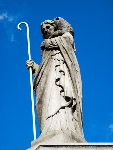
– photo by Mitch Waxman
Your humble narrator, amongst other failings, has a certain preference for the grandiose statuary of the late 19th and early 20th century at First Calvary Cemetery here in Queens. Baroque expressions such as these appeal to the comic book fan in me, looking for all the world like a Jack Kirby or Jim Steranko rendering. One half expects a concrete angel to… well, I stray…
– photo by Mitch Waxman
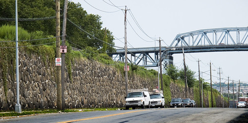
The southern section of First Calvary, found atop the cyclopean masonry observed on Review Avenue, offers glimpses of the Newtown Creek and panoramic views of industrial Brooklyn. Framing the open horizon of marshy western Queens and the forges of Brooklyn is the Kosciuszko Bridge, heroically carrying a vehicular river called the Brooklyn Queens Expressway over the infamous cataract. The elevation of these walls is actually quite high, an arcing and non euclidean structure which must be 2 to 3 stories at its apogee.
Am I overestimating? Check out this shot from the “street level” declination, aimed at the downward slope from halfway down Review Ave.–
And the shots below are from the other side of it, the topside of the wall.

– photo by Mitch Waxman
You won’t find the grandiose tombs or obsequious monuments to the famous on this side of First Calvary. This is where the “regular people” are buried- in their multitudes- in neatly defined rows of plots. The northwestern sections of Calvary, where the main gates are, and the northeastern- along Laurel Hill Blvd.- (both “High Ground”) are where you can find the princes of the 19th century city. Here, along Review Avenue, is where the middle and working class rest.

– photo by Mitch Waxman
My reasons for coming to this section must remain hidden, for now, suffice to say that I am still hunting for the grave of a man named Gilman (see “Tales of Calvary 7” for more speculation on this mysterious merchant from Massachusetts). Enjoying the relative quiet, I noticed one of the concrete pillboxes which I’ve also alluded to in earlier posts. These structures are all over Calvary, are often padlocked, and have aroused no small amount of curiosity in your humble narrator.

– photo by Mitch Waxman
Several conjectures -an access point to buried family mausoleums, a storage unit for groundskeepers, some sort of equipment shed- have assailed me as I observed these structures with their heavy iron lids and stout cement construction. An avid devotee of the macabre, I’ve often wondered aloud about just what is is that may be down there.

– photo by Mitch Waxman
This particular structure, as you can see, had been left unlocked. In fact, its heavy lid was just resting on the cement and its hinges had long ago stopped functioning.

– photo by Mitch Waxman
Nudging the lid back a few inches, a better than six foot drop was observed, which put its bottom some 4 feet below the surface as observed in the shot above. I activated the camera flash and illuminated quite a bit of airborne dust when the camera performed its intended action. As you can see, there were two modern shopping carts and part of a lamp down there. Puzzling- not for being trash, but… for… why, how, when, etc. You’d expect shovels or spades, but shopping carts and a lamp?

– photo by Mitch Waxman
Were I still the youthful and robust physical specimen I once was, I might have more to say about this, as I would have entered the yawning mystery for a closer look. However, as an aged physical coward and feckless quisling given to emotional stupor and irrational panic, the miasmal odor of the open hatch drove me backwards and I nearly passed into one of my episodes. Fighting off a faint, I labored to close the heavy lid and made for the Penny Bridge gates found on Laurel Hill Blvd. to escape the implications of that smell, which reminded me of an aquarium in need of filtration.
What can it be, that might be down there?


