Archive for the ‘kosciuszko bridge’ Category
mouldering bulk
It’s National Canadian Bacon Day, in these United States.

– photo by Mitch Waxman
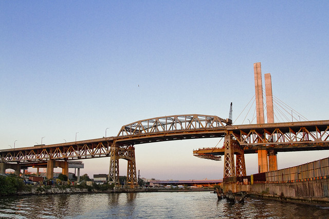
“Blowing it to bits” is a bit of an exaggeration, as offered by NYC’s tabloid headline writers (and the Governor of New York State), referring to a recently offered plan by the NYS DOT regarding the controlled demolition of the Kosciuszko bridge. Really… this isn’t going to be like the end of the movie Diehard, if anything it’s going to be a bit more like the end of Fight Club.
Documenting this project has been a long standing project of mine – this 2012 post tells you everything you could want to know about Robert Moses, Fiorella LaGuardia, and the origins of the 1939 model Kosciuszko Bridge. Just before construction started, I swept through both the Brooklyn and Queens sides of Newtown Creek in the area I call “DUKBO” – Down Under the Kosciuszko Bridge Onramp. Here’s a 2014 post, and another, showing what things used to look like on the Brooklyn side, and one dating back to 2010, and from 2012 discussing the Queens side – this. Construction started, and this 2014 post offers a look at things. There’s shots from the water of Newtown Creek, in this June 2015 post, and in this September 2015 post, which shows the bridge support towers rising. Additionally, this post from March of 2016 detailed the action on the Queens side. Most recently, here’s one from May of 2016, and one from June of the same year. Here’s one from August of 2016, and finally the December 2016 one.

– photo by Mitch Waxman
The NYS DOT held two meetings this week, one of which I attended, in which they described their plans. First – the central truss removal plan no longer involves the usage of maritime cranes. What their engineers described instead was the construction of four temporary towers which would support machinery which they described as “strand jacks,” which would lower the central truss down to couple of waiting flat top barges. Welding torches would be used to sever the truss’s links to the bridge superstructure, after the strand jacks are attached to support its weight. The truss will be lowered and secured to the barges, whereupon tugboats would guide it westward out of Newtown Creek, and across the harbor to New Jersey where its steel will be recycled.
They indicated this process would play out sometime around the end of April or the beginning of May. The DOT folks were quite vague about specific dates, saying that these were probable time frames but that they couldn’t commit to specifics at this point in time. This is problematic for me, personally, as I’m in the process of negotiating for boats to do Newtown Creek tours this summer, and the procedure described above includes the closure of the creek to all traffic for a couple of days. Worry, worry.

– photo by Mitch Waxman
There are two steel towers on either side of the Newtown Creek, which the engineering people indicated would be removed using conventional means (torches and cranes). Beyond the two steel towers, there are 21 spans supported by concrete piers – 10 in Brooklyn and 11 in Queens – which support roadway sections that range between large 230 foot long and 800 ton units and smaller ones that are 120 feet long which weigh in at 2-300 tons. These sections are the ones that DOT and the contractor partnership working for them are proposing to use the explosives on.

– photo by Mitch Waxman
The explosives used, and it should be mentioned that the very conservative FDNY Explosives Unit was present and participating in the discussion, would be shaped charges. What that means is that these things are essentially copper bars with high explosive material attached. The charges are placed at critical structural points on the bridge sections, and when their detonation is triggered, the copper chops right through the steel like a knife through butter. The sections which the explosives will be attached to will be “wrapped in filter fabric and conveyor belting equipment,” as they told us. It’s all very complicated.
The detonation will introduce structural deficits into the bridge sections, which will cause them to collapse in a controlled manner, effectively dropping straight down with little or no flyaway debris. There will be dust on impact with the ground, of course, which is a bit of a concern but the engineers say they have techniques to control that too.

– photo by Mitch Waxman
Vibration from the dropping sections – which again, weigh anywhere between 200 and 800 tons – is a concern, and the engineering folks described a series of dampening and avoidance technologies and techniques to handle that. These involved building engineered soil berms with internal steel structures, digging trenches, and so on. To be honest, I’m a bit concerned about what will amount to a seismic event, given the proximity of Calvary Cemetery and the somewhat ancient building industrial stock of West Maspeth and Eastern Greenpoint, but the FDNY guys seemed cool with it all.
As I said during the meeting – “If an FDNY Deputy Chief told me to go jump off the bridge, I’d probably listen to him or her,” but I have a more than normal level of respect for the FDNY’s opinions. One of the guys speaking at the meeting was a deputy chief, as a note.
As you may notice from the shot above, and the reason this whole demolition story is flying around, is that the DOT and their contractors are nearly done with constructing the eastern half of the new bridge.

– photo by Mitch Waxman
The 200,000 units a day of vehicle traffic carried by the Brooklyn Queens Expressway will soon be rerouted onto the new bridge, at which point the old bridge is irrelevant and in the way. A twin of the new bridge will then be erected on its footprints. As often mentioned in the past – this western side of the new span will include a pedestrian and bicycle path.

– photo by Mitch Waxman
In West Maspeth, once called Berlinville, you’ll find the sections of the roadway sitting on truck trailers and awaiting insertion into the span. Based on what I’m seeing, they should be installed shortly, and my guess would be that sometime in March the new span over Newtown Creek will be complete.

– photo by Mitch Waxman
One thing which I’m looking forward to in 2017 is a promised walk with the DOT over the new bridge shortly before traffic is rerouted. They’ve been a little vague as to when this will happen, but they have said repeatedly that it will occur. As a note, those are the tracks of the Lower Montauk branch of the LIRR, and a section of them known historically as “Deadman’s Curve.”

– photo by Mitch Waxman
Anywho, that’s your Kosciuszko Bridge replacement project update for the first quarter of 2017, see you on Monday at this – your Newtown Pentacle – with something completely different.
“follow” me on Twitter- @newtownpentacle
dark and shapely
Kosciuszko, Kosciuszko, men have named you…

– photo by Mitch Waxman
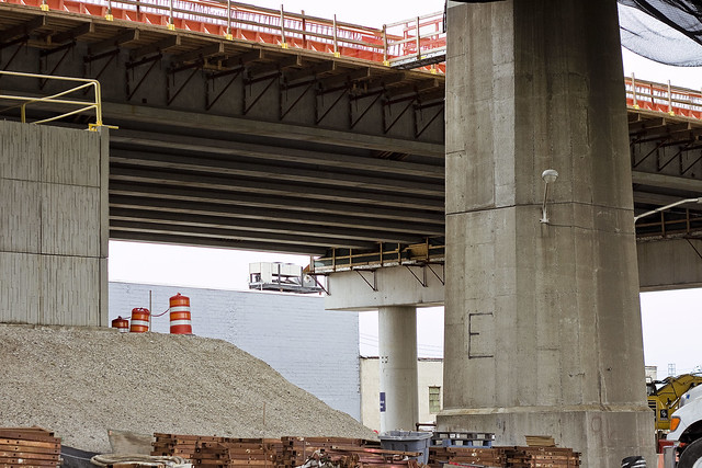
Over Thankgiving weekend, a visit was paid to the hazy borderlands of West Maspeth and Blissville. My goal was to check in on and shoot some photos on the progress the NYS DOT is making on Phase One of the Kosciuszko Bridge replacement project. Phase One involves the creation of half of the new span, the rerouting of the Brooklyn Queens Expressway, and the demolition of the 1939 era Kosciuszko Bridge, which overflies the lugubrious Newtown Creek.
Documenting this project has been a long standing project of mine – this 2012 post tells you everything you could want to know about Robert Moses, Fiorella LaGuardia, and the origins of the 1939 model Kosciuszko Bridge. Just before construction started, I swept through both the Brooklyn and Queens sides of Newtown Creek in the area I call “DUKBO” – Down Under the Kosciuszko Bridge Onramp. Here’s a 2014 post, and another, showing what things used to look like on the Brooklyn side, and one dating back to 2010, and from 2012 discussing the Queens side – this. Construction started, and this 2014 post offers a look at things. There’s shots from the water of Newtown Creek, in this June 2015 post, and in this September 2015 post, which shows the bridge support towers rising. Additionally, this post from March of 2016 detailed the action on the Queens side. Most recently, here’s one from May of 2016, and one from June of the same year. Finally, here’s one from August of 2016.

– photo by Mitch Waxman
The roadway now extends out over the water and is firmly shadowing the concrete devastations of Queens, nearly crossing the LIRR Lower Montauk tracks. The BQE Onramp also seems to be coming along, and I suspect that the DOT’s contractors will be joining the bridge span to the Queens side approaches pretty soon.

– photo by Mitch Waxman
Speaking of the BQE Onramp, there it is. In the foreground is one of the structural steel sections which will be joined to the span and support the road surface. Not pictured are the “panels” of the road surface, which arrived a couple of days later and which were noticed during a subsequent and unrelated visit to the area.

– photo by Mitch Waxman
In the shot above, you can see how the sections are attached. This is a cable stay bridge, of course. The roadway above will carry four lanes of two way traffic, but it’s just half of the new bridge. When the western half of the project is complete, there will be four lanes in each direction, and there’s also going to be a bicycle and pedestrian path.
That’s awesome. Cannot wait to shoot from up there.

– photo by Mitch Waxman
The new bridge, as I’ve been mentioning for several years at this point, is going to be quite a bit lower than the 1939 model. That’s going to bring noise issues to Maspeth and Blissville, I fear, but let’s see what DOT has planned.

– photo by Mitch Waxman
The NYS DOT is currently wondering what to do with the areas on both sides of the Creek which these columns rise from. There’s talk of public space and treating the two spots in the manner of a park or playground.
– photo by Mitch Waxman
Further back in Queens, to the north actually, the approaches to the new bridge seem to be ready for business. I haven’t managed to get up there yet, but cross your fingers, maybe I can talk the DOT folks into a walk through soon.

– photo by Mitch Waxman
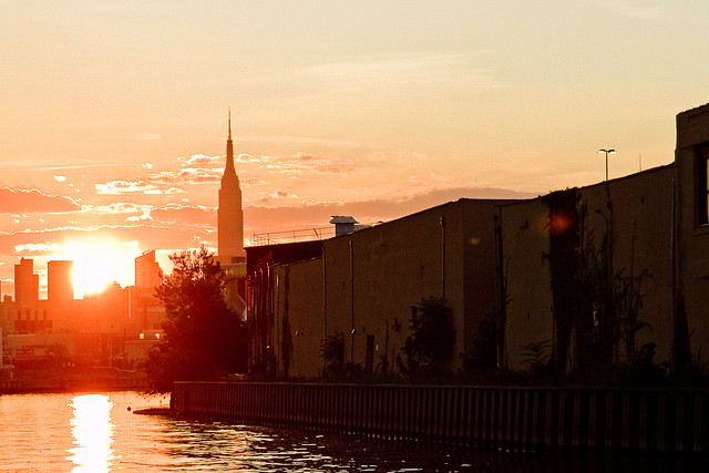
Given the fantastic sort of luck for which I’m distinguished, just as I started back for home (cutting through Calvary Cemetery) the misty murk occluding the burning thermonuclear eye of God itself began to break up, allowing the sky to turn blue and light to suffuse. I turned around and grabbed one last shot, while cursing.
“follow” me on Twitter- @newtownpentacle
leaping shadows
Lets talk about the Kosciuszcko Bridge, huh?

– photo by Mitch Waxman
Since the big bridge over Newtown Creek’s 77th birthday is coming up – August 23rd for the vulgarly curious – one decided to walk over and through Calvary Cemetery into West Maspeth the other day and check out the latest progress which the NYS DOT and their contractors are making on replacing it. The Kosciuszcko Bridge replacement project is humming along.
As a note, this post represents no special access or anything, just some specialized knowledge about Newtown Creek and the points of view thereupon which I am privy to. If there’s an angle of view on the Creek I don’t know about by this point, I will buy you a drink for showing it to me.

– photo by Mitch Waxman
As is my habit, one has been keeping a running tally of posts about the project.
To start – this 2012 post tells you everything you could want to know about Robert Moses, Fiorella LaGuardia, and the origins of the 1939 model Kosciuszko Bridge. Just before construction started, I swept through both the Brooklyn and Queens sides of Newtown Creek in the area I call “DUKBO” – Down Under the Kosciuszko Bridge Onramp. Here’s a 2014 post, and another, showing what things used to look like on the Brooklyn side, and one dating back to 2010, and from 2012 discussing the Queens side – this. Construction started, and this 2014 post offers a look at things. There’s shots from the water of Newtown Creek, in this June 2015 post, and in this September 2015 post, which shows the bridge support towers rising. Additionally, this post from March of 2016 detailed the action on the Queens side. Most recently, here’s one from May of 2016, and one from June of the same year.

– photo by Mitch Waxman
The roadway which will be the easterly BQE section leading out of Queens is now largely in place. There’s still a bunch of work going on up there, presumptively it involves the sort of rebar work observed in the May 2016 post linked to above.

– photo by Mitch Waxman
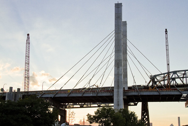
The shape of the cable stay section of the new bridge is beginning to form up as well.

– photo by Mitch Waxman
The steel sections are prefabricated and shipped to the job site via flat bed truck, where they’re then hoisted up and attached to the towers and cables.

– photo by Mitch Waxman
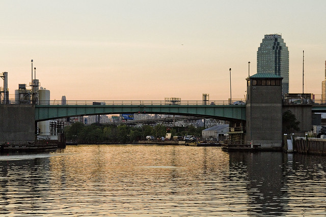
Looking down 56th road from Blissville into Maspeth. The area in the left hand side of the shot used to be an NYPD tow yard, which was a great example of NYC’s macabre sense of humor. NYPD tow pounds are typically in places which you can’t reach without a car, and since they’ve just taken your car…

– photo by Mitch Waxman
Looking north towards Sunnyside from 56th road. You can really discern the difference in height between the 1939 and modern bridges in the shot above. Apparently, part of the traffic engineering underlying the new bridge project is to eliminate the steep incline from the approaches.

– photo by Mitch Waxman
Looking south towards Brooklyn, while still on 56th road. The property fence line I’m shooting over is the former home of the Phelps Dodge refinery, which is said to be a particularly toxic hot spot.

– photo by Mitch Waxman
A bit closer to the water, on another part of the former Phelps Dodge properties which isn’t quite so “hot,” pollution wise. This is the parking lot of a wholesaler catering to the restaurant trade.

– photo by Mitch Waxman
The cable stay span of the new bridge is growing steadily towards Brooklyn in the shot above. To me, it looks like it’s going to be connected to the Brooklyn side ramp fairly soon.

– photo by Mitch Waxman
A close up on the ramp, and you can see the itty bitty construction guys at work right on the edge.

– photo by Mitch Waxman
Same perspective, but wide angle. That’s the Newtown Creek flowing below, and we are looking west towards Manhattan. Again, notice the height differential between the two spans.

– photo by Mitch Waxman
Looking south again, this time from Maspeth’s 43rd street. The contractors have a lot of their equipment and prefabricated materials staged out here.

– photo by Mitch Waxman
Back on 43rd street, but this time from the very edge of the project site, looking south along the spine of the BQE.
There you are.
Upcoming Events and Tours
Sunday, August 14th, 11:00 p.m. – 1:00 p.m. –
Calvary Cemetery Walking Tour,
with Atlas Obscura. Click here for more details.
Sunday, August 21, 11:00 a.m. – 1:00 p.m. –
Poison Cauldron Walking Tour,
with Atlas Obscura. Click here for more details.
Wednesday, August 24, 6:00 p.m. – 8:00 p.m. –
Port Newark Boat Tour,
with Working Harbor Committee. Click here for more details.
“follow” me on Twitter- @newtownpentacle
unequal heating
Creek Week concludes, in today’s post.
– photo by Mitch Waxman
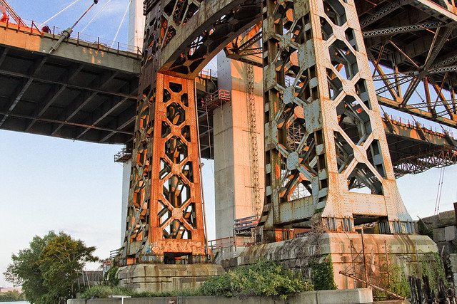
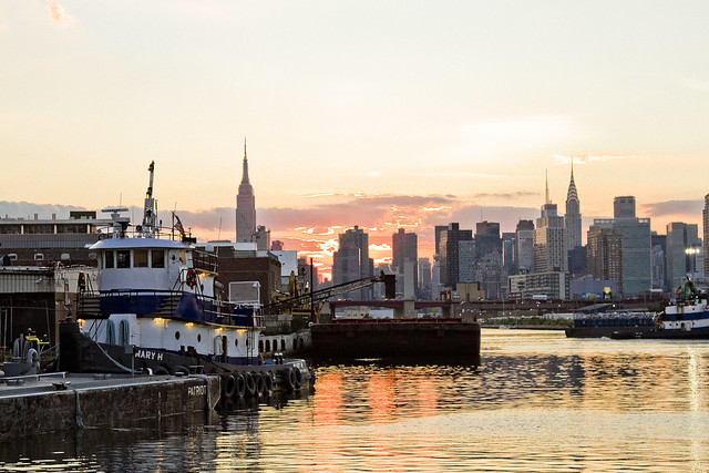
That’s the Kosciuszcko Bridge replacement project pictured above, with the 1939 Robert Moses model bridge providing a backdrop to the under construction cable stay model. That’s the Brooklyn side, for the curious. This is a $1.2 billion replacement effort, “fast tracked” by Governor Cuomo, which is intended to replace what’s considered to be the most dangerous bridge in New York State – which happens to carry hundreds of thousands of vehicle trips a day as the Brooklyn Queens Expressway runs across its 2.1 mile long structure (along with its approaches).
– photo by Mitch Waxman
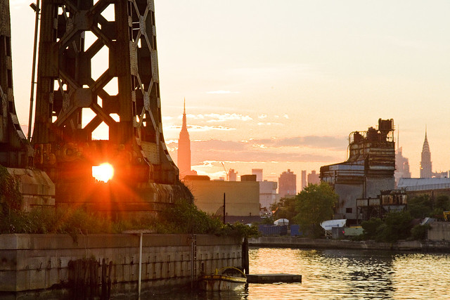
These shots were captured while onboard a NY Water Taxi hired for the evening by the Open House NY organization, and my colleague T. Willis Elkins and I were onboard to represent Newtown Creek Alliance and narrate to two sold out crowds. The second trip was heading back out from the Newtown Creek towards the East River just as sunset was occurring, and as always – Newtown Creek was and is a visual spectacular.
– photo by Mitch Waxman
One has been trying to capture as many angles and shots as possible of the old Kosciuszcko Bridge for a couple of years now, simply because within the next 24-36 months it will have been eradicated from common memory.
This whole “Newtown Creek Historian” business isn’t just about revealing the past, it’s about leaving behind a visual record for those who haven’t been born yet about what the place looked like during its superfund and early 21st century transformational period.
– photo by Mitch Waxman
I’ve mentioned it before, but the plan which the State DOT has put forward is that once the eastern side of the new bridge is complete, they are going to reroute the BQE onto it. Then, they’re going to demolish the 1939 model, and in its footprint, build the western section of the new cable stay bridge. The great news about that is that there is going to be a pedestrian and bicycle path on the western side of the bridge.
One looks forward to walking the camera across, and getting aerial shots from up there.
– photo by Mitch Waxman
The burning thermonuclear eye of God itself was setting in the west as our NY Water Taxi navigated back towards the East River. That’s Blissville in Queens on the right hand side of the shot above, and the former location of not just Charles Pratt’s “Queens County Oil Works” but just about the very spot where the first large scale oil refinery in the United States – Abraham Gesner’s “North American Kerosene Gas Light Company” was founded.
– photo by Mitch Waxman
On the Brooklyn or Greenpoint side of Newtown Creek, the former home of the Standard Oil Company of New York and birthplace of what would be one day known as Mobil Oil is closest to the camera, which are now the ExxonMobil Greenpoint Remediation Project properties at 400 Kingsland Avenue.
Sitting on part of the former oil company properties in Greenpoint is the NYC DEP’s Newtown Creek Wastewater Treatment Plant, largest and newest of NYC’s 14 sewer plants.
– photo by Mitch Waxman
DUGABO – or Down Under the Greenpoint Avenue Bridge Onramp – is the heart of petroleum country on Newtown Creek. Greenpoint Avenue heads west into Brooklyn, terminating at the East River at Transmitter Park, whereas it continues into Queens and once having crossed Queens Blvd. – it transmogrifies into Roosevelt Avenue and continues all the way out into Flushing.
– photo by Mitch Waxman
From a maritime industrial point of view, the DUGABO area surrounding the Greenpoint Avenue Bridge is probably one of the busiest sections of Newtown Creek in the 21st century. SimsMetal and Allocco Recycling host regular tug and barge traffic, as does Metro fuel.
In the distance is the Pualski Bridge and the towers of the Shining City of Manhattan.
Upcoming Events and Tours
Saturday, August 6th, 2:00 p.m. – 4:00 p.m. –
Insalubrious Valley Walking Tour,
with NY Adventure Club. Click here for more details.
Sunday, August 14th, 11:00 p.m. – 1:00 p.m. –
Calvary Cemetery Walking Tour,
with Atlas Obscura. Click here for more details.
Sunday, August 21, 11:00 a.m. – 1:00 p.m. –
Poison Cauldron Walking Tour,
with Atlas Obscura. Click here for more details.
“follow” me on Twitter- @newtownpentacle
tourist parties
Bottoming out in Blissville, in today’s post.

– photo by Mitch Waxman
A recent Saturday found me speaking at an early morning waterfront event in Astoria recently, which was followed by conducting a walking tour of the Poison Cauldron of the Newtown Creek in the late afternoon. Left with a gulf of time to fill between the two, I decided to spend it by walking from Astoria to Greenpoint via Blissville and checking in on what’s going on with the Kosciuszko Bridge project on the border of West Maspeth and the aforementioned Blissville section of Long Island City.
A bit of history trivia is offered – the Kosciuszko Bridge is built along the “legal” south eastern border of Long Island City and what was once known as “Newtown.” For the curious, the North Eastern border was more or less defined by Woodside Avenue.

– photo by Mitch Waxman
The roadway ramps on the Queens side of the Kosciuszko Bridge project are now overflying Review/58th avenue and reaching towards Newtown Creek. The Kosciuszko Bridge project engineers have always said that the northern section of the project would lag behind the southern, or Brooklyn, side.
Longtime readers of this – your Newtown Pentacle – will report that I’ve been keeping track of things at the Kosciuszko Bridge, with this recent post being the latest report from the Brooklyn side.

– photo by Mitch Waxman
For a running history of Newtown Pentacle coverage on the subject – this 2012 post tells you everything you could want to know about Robert Moses, Fiorella LaGuardia, and the origins of the 1939 model Kosciuszko Bridge. Just before construction started, I swept through both the Brooklyn and Queens sides of Newtown Creek in the area I call “DUKBO” – Down Under the Kosciuszko Bridge Onramp. Here’s a 2014 post, and another, showing what things used to look like on the Brooklyn side, and one dating back to 2010, and from 2012 discussing the Queens side – this. Construction started, and this 2014 post offers a look at things. There’s shots from the water of Newtown Creek, in this June 2015 post, and in this September 2015 post, which shows the bridge support towers rising. Additionally, this post from March of 2016 detailed the action on the Queens side.
– photo by Mitch Waxman
Supposedly, I’m meant to be gaining some access to the actual worksite in Queens fairly soon, although the only thing keeping me from having walked the site is my own discretion. As far as “urban exploring” goes, this would be an easy conquest. Regardless, I’m looking forward to walking the site sometime in June.
– photo by Mitch Waxman
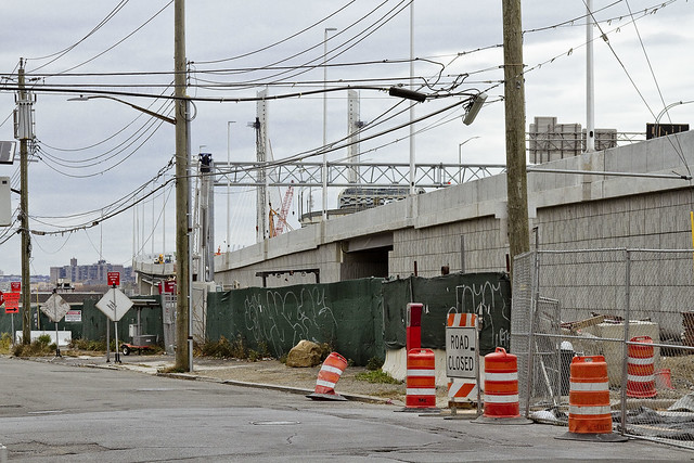
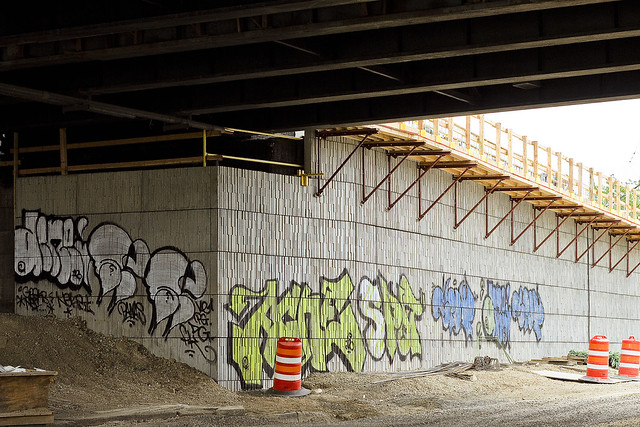
To wit, a graffiti crew which decided to adorn the still under construction masonry of the new Brooklyn Queens Expressway ramps leading to the span. Another crew a little bit further north of here weren’t quite as colorful, and instead painted white swastikas on the brick masonry of the BQE on-ramps.
What you see above is not graffiti, incidentally, it’s time.
Time and opportunity.
Upcoming Events and Tours
Saturday, June 4, 11:00 a.m. -1:30 p.m. –
DUPBO: Down Under the Pulaski Bridge Onramp,
with Brooklyn Brainery. Click here for more details.
“follow” me on Twitter- @newtownpentacle


