Archive for the ‘newtown creek’ Category
Hunters Point Avenue Bridge Centennial, Dec. 11

– photo by Mitch Waxman
Gaze upon it, lords and ladies, a risible talisman of permanence amidst an ever changing industrial landscape… The Hunters Point Avenue Bridge.
A recent post was offered for consideration at this, your Newtown Pentacle, which hinted at certain remarkable events about to occur in its environs and discussed a small part of the rather expansive history of this largish bit of motile steel which spans Dutch Kills.
Glory then, in the announcement of a free walking tour celebrating its centennial.
from nycbridges100.org

NEW YORK CITY BRIDGE CENTENNIAL COMMISSION AND NEWTOWN CREEK ALLIANCE TO HOST WALKING TOUR OVER HUNTERS POINT AVENUE BRIDGE MORNING OF DECEMBER 11TH
The New York City Bridge Centennial Commission (NYC BCC) and Newtown Creek Alliance announced today that they will sponsor a free walking tour of the Hunters Point Avenue Bridge in Long Island City on Saturday, December 11, 2010 at 11 a.m. to celebrate its 100th birthday.
“It’s important to celebrate these milestones as a way to show how much we rely on all these crossings in our day-to-day lives,” said NYC BCC President Sam Schwartz.

– photo by Mitch Waxman
Your tour guides for this centennial event will be Newtown Creek Alliance and Working Harbor Committee’s Bernard Ente, and a certain humble narrator will be assisting him in meager ways.
This location is awfully close to both legendary Greenpoint and to the heart of Long Island City, and quite close to Manhattan via subway. Here’s a google map with the location of the Bridge, and the meet-up point at 21st street and Hunters Point Avenue is called out.
from nycbridges100.org
The original Hunters Point Avenue Bridge dates back to 1874 when the bridge was a wooden structure. From 1874 to 1907 an iron bridge was in place before being replaced in 1910 by a double-leaf bascule bridge. It was again rebuilt in the early 1980s as a single-leaf bascule bridge. Bascule bridges are designed with a counterweight that balances the span as it swings upward (a single leaf lifts up from one end while a double leaf lifts up from both sides in the middle of the span).
The bridge is located between 27th and 30th streets in Long Island City and is situated four blocks east of the Borden Avenue Bridge. The span is 21.8 meters long and has two lanes, one in each direction. It has experienced higher traffic volumes over the last year and a half while the Borden Avenue Bridge has been closed for construction in this heavily industrialized area.

– photo by Mitch Waxman
Spectacular views of Dutch Kills, as well as knowledgeable and unbiased narration, can be had for the price of attendance alone. Attendees are advised to bring cameras, as this is a particularly photogenic section of the Newtown Creek watershed.
from nycbridges100.org
The meeting point for the tour will be at Hunters Point Avenue at 21st Street outside the 7 train station. If you would like to participate, please email tour guide Bernie Ente at info@entephoto.com.
About the NYC Bridge Centennial Commission
The NYC Bridge Centennial Commission is a 501 c 3 non-profit comprised of public and privateorganizations to commemorate the centennials of several NYC bridges and raise infrastructure awareness.
About the Newtown Creek Alliance
The Newtown Creek Alliance represents interests of community residents and local businesses who arededicated to restoring community health and vibrant water dependent commerce along Newtown Creek.

– photo by Mitch Waxman
Dutch Kills is a familiar sight to regular readers of this, your Newtown Pentacle, but must be experienced first hand by all interested in the story of the Newtown Creek. This will not be a rigorous walking experience- sneakers or other comfortable shoes should be sufficient as we won’t be leaving the sidewalk- but if icy conditions occur- use good judgement.
Undoubtedly, it will be cold, and the event will be happening rain, shine, or snow- so gauge your outerwear according to forecasted weather conditions.
For those interested in further discussion with other antiquarians and enthusiasts, we are planning an after event visit to a local diner for coffee, luncheon, and conversation.
from nyc.gov
Hunters Point Avenue is a two-lane local City street in Queens. Hunters Point Avenue is oriented east-west and extends from 21st Street to the Long Island Expressway/Brooklyn Queens Expressway interchange in Queens. The avenue is parallel to and approximately one block south of the Long Island Expressway. The Hunters Point Bridge over Dutch Kills is situated between 27th Street and 30th Street in the Long Island City section of Queens, and is four blocks upstream of the Borden Avenue Bridge. It is a bascule bridge with a span of 21.8m. The general appearance of the bridge has been significantly changed since it was first opened in 1910. The bridge provides a channel with a horizontal clearance of 18.3m and a vertical clearance, in the closed position, of 2.4m at MHW and 4.0m at MLW. The bridge structure carries a two-lane, two-way vehicular roadway with sidewalks on either side. The roadway width is 11.0m, while the sidewalks are 1.8m wide. The width of the approach roadways vary from the width of the bridge roadway. The west approach and east approach roadways are 13.4m and 9.1m, respectively.
The first bridge at this site, a wooden structure, was replaced by an iron bridge in 1874. That bridge was permanently closed in 1907 due to movement of the west abutment, which prevented the draw from closing. It was replaced in 1910 by a double-leaf bascule bridge, designed by the Scherzer Rolling Lift Bridge Company. The bridge was rebuilt in the early 1980′s as a single-leaf bascule, incorporating the foundations of the previous bridge.
Incidentally…
a photo in the same series as the one below was recently exhibited here- in the “from some point in space” posting about Dutch Kills and the Hunters Point Avenue Bridge.

– photo by Mitch Waxman
While doing supplemental research about the place, I came across the following shot embedded in a scanned “google book”, and the two images form an interesting parallel. The BW shot, you see, is from 1921.
Coincidence abounds, but I believe my forebear was shooting from a similar if not same vantage as I would be at some four score and nine years or 24,855 days later.

– Photo from “The Newtown Creek industrial district of New York City By Merchants’ Association of New York. Industrial Bureau”
confines of our kingdom
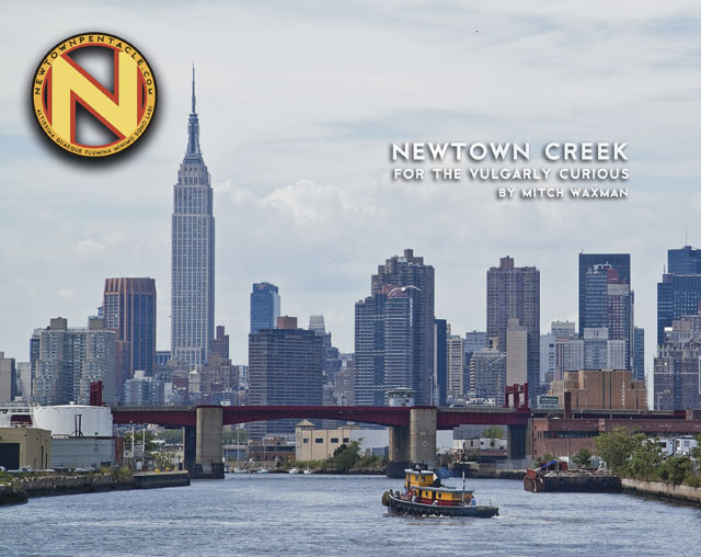
“Newtown Creek for the Vulgarly Curious” is a fully annotated 68 page, full-color journey from the mouth of Newtown Creek at the East River all the way back to the heart of darkness at English Kills, with photos and text by Mitch Waxman.
Check out the preview of the book at lulu.com, which is handling printing and order fulfillment, by clicking here.
Every book sold contributes directly to the material support and continuance of this, your Newtown Pentacle.
indefinable odors

– photo by Mitch Waxman
Down by Dutch Kills, one must persevere to maintain some inkling of hope for the future of mankind.
Saying that, however, in its own way Dutch Kills is actually quite a lovely place- as storied industrial centers which have seen better days typically are. A canalized waterway, Dutch Kills is a tributary of that languid cautionary tale known as the Newtown Creek, and has been isolated for several seasons from its principate source by emergency bridge construction and a changing industrial landscape. I’m down here a lot of course, most recently in the “from some point in space” posting of November 3rd, which includes an intriguing set of high elevation shots of the area which I recently managed to capture.
from nyc.gov
Hunters Point Avenue is a two-lane local City street in Queens. Hunters Point Avenue is oriented east-west and extends from 21st Street to the Long Island Expressway/Brooklyn Queens Expressway interchange in Queens. The avenue is parallel to and approximately one block south of the Long Island Expressway. The Hunters Point Bridge over Dutch Kills is situated between 27th Street and 30th Street in the Long Island City section of Queens, and is four blocks upstream of the Borden Avenue Bridge. It is a bascule bridge with a span of 21.8m. The general appearance of the bridge has been significantly changed since it was first opened in 1910. The bridge provides a channel with a horizontal clearance of 18.3m and a vertical clearance, in the closed position, of 2.4m at MHW and 4.0m at MLW. The bridge structure carries a two-lane, two-way vehicular roadway with sidewalks on either side. The roadway width is 11.0m, while the sidewalks are 1.8m wide. The width of the approach roadways vary from the width of the bridge roadway. The west approach and east approach roadways are 13.4m and 9.1m, respectively.
The first bridge at this site, a wooden structure, was replaced by an iron bridge in 1874. That bridge was permanently closed in 1907 due to movement of the west abutment, which prevented the draw from closing. It was replaced in 1910 by a double-leaf bascule bridge, designed by the Scherzer Rolling Lift Bridge Company. The bridge was rebuilt in the early 1980’s as a single-leaf bascule, incorporating the foundations of the previous bridge.

– photo by Mitch Waxman
Seldom commented, the Hunters Point Avenue Bridge segments Dutch Kills neatly, and has done so for nigh on a century now. The marshes and streams which once typified the area before the advance of railroad and vast agglutination of industrial installation are long gone, relegated to subterranean sewers and masonry clad spillways, but a century ago- the Hunters Point Avenue Bridge (and its predecessors) allowed egress between the terrestrial isolation of the Long Island City center and the rest of western Queens.
The NY Times, in 1908, commented that Long Island City might someday be known as “A city of bridges” due to the many crossings over the tributaries of the Newtown Creek and the presence of mighty Queensboro at its center.
from federalregister.gov
The Hunters Point Avenue Bridge, at mile 1.4, over the Dutch Kills has vertical clearances of 8 feet at mean high water and 13 feet at mean low water. The existing regulations for the Hunters Point Avenue Bridge in 33 CFR 117.801(d) require the draw to open on signal if at least a one-hour advance notice is given to the drawtender at the Grand Street/Avenue Bridge, the NYCDOT Radio Hotline, or NYCDOT Bridge Operations Office. In the event the drawtender is at the Roosevelt Island Bridge or the Borden Avenue Bridge, up to an additional half-hour delay may occur.
The bridge owner, the New York City Department of Transportation (NYCDOT), submitted bridge opening log data to the Coast Guard for review. The bridge owner plans to operate these bridges with multiple crews of drawtenders. The two-hour advance notice should allow sufficient time for the crews to operate these bridges due to the close proximity of the bridges to each other. Recent yearly openings have been relatively low which will allow the bridge owner to utilize the roving crew concept and still meet the needs of navigation.

– photo by Mitch Waxman
The Hunters Point Avenue Bridge (the 1910 version) was configured differently than the modern structure when first built, although the original was constructed for some $95,214 from plans by the Scherzer Rolling Lift Bridge Company with the dirty work performed by the Duseath Engineering Company of 114 Liberty St. NY. As you’d imagine, there is a certain logic behind the esoterica presented about this obscure little bridge found in a literal “industrial backwater” in Queens.
But… I can’t tell you what is is yet…
from nysdot.gov
About 1900, most of the Newtown Creek was bulkheaded and occupied by about fifty industrial properties. Undeveloped or less developed sections without bulkheads included Dutch Kills, about 2,000 feet of shoreline in Queens just above Dutch Kills with two LIRR lighterage piers, about 1,000 feet of shoreline in Queens near the Penny Bridge, and about 3,500 feet of shoreline downstream of Maspeth Avenue in Brooklyn.15 Dutch Kills, and the Queens side of Newtown Creek, just upstream of Dutch Kills, were developed circa 1905-1912, largely through the efforts of the Degnon Terminal & Realty Company. The Degnon firm created an industrial park with rail and marine access around Dutch Kills between about Hunters Point and 47th Avenue, Dutch Kills subsequently was included within USACE dredging projects. Without federal assistance, Degnon created a 150-foot-wide channel with 2,400 feet of bulkhead, including a turning basin. To create rail links to the development, Degnon helped the LIRR build a new 1,000-acre freight terminal circa 1907 along Newtown Creek east of Dutch Kills on property bought from Calvary Cemetery, including several short piers intended to handle heavy freight such as brick, coal, lumber, and ice. From this terminal, a private Degnon Terminal Railroad was created, largely through local streets. On newly filled marshy margins of Dutch Kills, Degnon Terminal & Realty promoted industrial development both on and away from the water. One iron works and several large building materials firms occupied the Degnon waterfront by the early 1920s. Reconstruction of the two movable bridges over Dutch Kills circa 1908-10 contributed to these developments. On other Degnon lots, large firms included the American Eveready Company and the American Chiclet Company, respective makers of batteries and candy.16 Facilitating this growth was the construction of the Queensboro Bridge (1909) and the start of the operation of the IRT subway line in 1917.

– photo by Mitch Waxman
Unfortunately, I can’t announce the news yet… Let’s just say that it would be a good idea to leave the 11th of December open, and that Long Island City is terrible in its grandeur during the winter months.
More on this will be forthcoming by the end of the week.
from wikipedia
Edward Byrne began his civil engineering career in 1886 with the New York City Aqueduct Commission on the construction of the Croton Water Supply System. It is of interest that on this project he met Robert Ridgway, who also was destined to become a distinguished engineer and an outstanding civil servant.
From 1889 to the close of 1897, Byrne worked on highways and bridges for the old Department of Public Works of New York City.
On January 1, 1898, he joined the Department of Bridges and began a striking and noteworthy service which ended in November, 1933, with his resignation from the position of Chief Engineer of the Department of Plant and Structures (the successor of the Bridge Department), in order to assume the duties of Chief Engineer of the Triborough Bridge. His thirty-six years of service in the Department of Bridges, and its successor, the Department of Plant and Structures, may be divided into two periods.
Borden Avenue Bridge
During this period, he was in charge of bridge construction and maintenance, supervising the construction of the Willis Avenue Bridge over the Harlem River, the Vernon Avenue Bridge, the Borden Avenue and Hunters Point Bridges over Dutch Kills, and the old bridge over Flushing River.

– photo by Mitch Waxman
Also, as a note:
I get asked all the time what these signs mean, what they indicate, and how seriously they should be regarded. The powers that be don’t make it easy to find out, for despite the “for more information” attribution, the City doesn’t go into much detail at nyc.gov/dep about them. Partly, this is due to the vogue followed by municipal authorities in recent years which allows private contractors to perform public work. The contractor is under no obligation to release their work into the public domain, as government workers are, and many important details about our metropolis ends up hidden behind corporate firewalls.
Here’s a little of the Batman type detection required to penetrate a purposely obtuse subject, which is a skill I’ve been developing over the lifetime of this, your Newtown Pentacle.
Quoting from hydroqual.com
The Bowery Bay WPCP is permitted by the NYSDEC under SPDES permit number NY-0026158. The facility is located at 43-01 Berrian Blvd., Astoria, NY, 11105 in the Astoria section of Queens, on a 34.6 acre site adjacent to the Rikers Island Channel, leading into the Upper East River, bounded by Berrian Blvd. and Steinway Street. The Bowery Bay WPCP serves an area of approximately 16,105 acres in the Northwest section of Queens, including the communities of KewGarden Hills, Rego Park, Forest Hills, Forest Hills Gardens, North Corona, South Corona, Lefrak City, Elmhurst, East Elmhurst, Jackson Heights, Maspeth, Woodside, Sunnyside Gardens, Sunnyside, Hunters Point, Long Island City, Astoria, Astoria Heights, Steinway, Ravenswood, and Roosevelt Island.
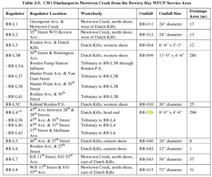
and from the same document this text and chart
The Low Level service area contains 46 regulators, of which 19 interconnected regulators discharge to the Newtown Creek during wet weather through the 13 CSOs. Of these 13 CSOs, 6 discharge to the tributary Dutch Kills (BB-004, 009, 010, 026, 040, and 042), and 6 discharge to Newtown Creek(BB-011, 012, 013, 014, 015, and 043). An additional 2-feet, 8-inches x 4-foot outfall, BB-049, is listed in the Bowery Bay WPCP SPDES permit as discharging to Dutch Kills near 21st Street, but no further information is available such as which regulator it is connected to.
lutes and dancing

– photo by Mitch Waxman
Wandering aimlessly across the pattern that underlies the streets of Long Island City, a logical course whose every obstacle is modern, one day I found myself in the Empty Corridor. Not so empty as it used to be, for the continuing diversion of traffic away from the Borden Avenue Bridge funnels vast numbers of vehicles through these streets- some of which are still clad in only their original Belgian Block cobbles.
from wikipedia
Public property
- It is generally legal to photograph or videotape anything and anyone on any public property, with some exceptions.
- Taking a photograph while on an airplane is banned in many places, and many mass transit systems prohibit taking photographs or videos while on board buses or trains or inside of stations. (It is unknown whether such prohibitions are legal, due to transit systems in the United States often being considered public places.) Photography is against Port Authority rules in New York and New Jersey’s PATH Train system. Photography and videography are also prohibited in the U.S. Capitol, in courthouses, and in government buildings housing classified information. Bringing a camera phone into one of these buildings is not permitted either.
- Photographing or videotaping a tourist attraction, whether publicly or privately owned, is generally considered legal, unless explicitly prohibited by posted signs.

– photo by Mitch Waxman
Always on the lookout for intriguing items to photograph, your humble narrator often finds himself in front of scenes such as this one, and possessed by a paradoxical mindset. On one hand, the artwork which adorns this octagonal stop sign is well wrought, and skillfully placed for maximum esthetic value. On the other, this is vandalism- and it creates a dangerous situation regarding the passage of vehicles through a now unmarked intersection.
Further, I’m often at odds with the ideation of taking photos of such displays at all.
from wikipedia
Private property
Photography may be prohibited and/or restricted within an area of property by the property owner. At the same time, a property owner generally cannot restrict the photographing of their property by individuals who are not located within the bounds of the property.
In order to film on someone else’s property, permission must be received from the owner.
Photographing of privately-owned property that is generally open to the public (i.e. retail) is permitted unless explicitly prohibited by posted signs.
Some jurisdictions have laws regarding filming while in a hospital or health care facility. Where permitted, such filming may be useful in gathering evidence in cases of abuse, neglect, or malpractice.

– photo by Mitch Waxman
Public art, even when unsigned, is still considered to be the property of the original artist. Technically speaking, I’m not allowed to “publish” this image without the express permission of the artist and despite the fact that I own the copyright on the image, I can’t transfer or sell it without permission.
Were this posting commercial in nature, in fact, a court of law could assign damages and restitution. Art commissioned and owned by “The State” on behalf of the public is a different matter, and a complicated legal ground that’s ever shifting about. Generally, if it’s owned by the U.S. government and produced before the 1970’s it’s probably in the public domain.
Usually, I just leave this sort of thing to the prolific Ms. Heather over at NY Shitty, as she’s much better at finding new and exciting street art than I and is possessed of a curatorial spirit toward her discoveries.
But this one I couldn’t stop from shooting. Click the image for the larger size, as these are very nicely drawn images.
from wikipedia
Copyright is a set of exclusive rights granted by the law of a jurisdiction to the author or creator of an original work, including the right to copy, distribute and adapt the work. Exceptions and limitations to these rights strive to balance the public interest in the wide distribution of the material produced and to encourage creativity. Exceptions include fair dealing and fair use, and such use does not require the permission of the copyright owner. All other uses require permission and copyright owners can license or permanently transfer or assign their exclusive rights to others. Copyright does not protect ideas, only their expression or fixation. In most jurisdictions, copyright arises upon fixation and does not need to be registered. Copyright protection applies for a specific period of time, after which the work is said to enter the public domain.
peace rests nevermore

– photo by Mitch Waxman
Area wags were abuzz in the days leading up to Wednesday the 17th of November, as a hush hush series of emails suggested that on the morning of the 17th an important and remarkable moment in the long history of Newtown Creek would occur. Your humble narrator braved the stinging winds tormenting the megalopolis that day, and perambulated from raven tressed Astoria to hoary Greenpoint in record time.
Your eyes aren’t fooling you either, those are actual white cap waves on Newtown Creek.
Newtown Creek has a length of four miles. Its natural depth was 12 feet, falling to four feet at the head of navigation. In the early days its shores presented a beautiful sight. In the background were the hills covered with trees. In the swamps below, the stream and its tributaries had their rise. Broadening on its way, the stream flowed quietly between wooded elevations and further along lowlands until it mingled its waters with the salt of the East River. When the tides met, the backing up of these tides caused the stream to overflow the marshes, and this fact led the Indians to name the waterway “Mispat”, that is, an overflowing tidal stream. An ancient deed from the Indians calls Maspet Kills “Quandoequareous”. The creek abounded with seafood and was also a favorite swimming spot.

– photo by Mitch Waxman
Borough President of infinite Brooklyn, Marty Markowitz suddenly appeared and “turned on the high beams”, meeting and greeting with the various dignitaries who were arriving.
from wikipedia
Marty Markowitz (born February 14, 1945) is the Borough President of Brooklyn, New York City, the most populous borough in New York City with nearly 2.6 million residents. Markowitz was first elected borough president in 2001 after serving 23 years as a New York State Senator. His third term began in January, 2010.

– photo by Mitch Waxman
Shmoozing while waiting for the event to begin, from left is Paul Gallay, Markowitz, and Senator Martin Malave Dilan. At the far right, seated, is Riverkeeper’s Philip Musegrass.
from nysenate.gov
Elected to the New York State Senate in November, 2002, Martin Malave Dilan is serving his fourth term in the 17th Senatorial District. In an unusual twist for a Senate freshman, Senator Dilan was appointed the Assistant Minority Leader of Conference Operations. In 2007, Senator Dilan was appointed Chairman of the Minority Conference. Continuing his role as a leader, in 2009, Senator Dilan was appointment Senior Assistant Majority Leader. As a Senator representing Brooklyn, Senator Dilan continues his extraordinary career in public service. The 17th Senate District encompasses the North Brooklyn communities of Bushwick, Williamsburg, Greenpoint, Cypress Hills, City-Line, East New York, Bedford-Stuyvesant, and Brownsville.

– photo by Mitch Waxman
Then the Governor-Elect of New York State, current Attorney General Andrew Cuomo, arrived.
from wikipedia
Andrew Mark Cuomo (pronounced /ˈkwoʊmoʊ/; born December 6, 1957) is the governor-elect of New York State. He is the 64th New York State Attorney General, in office since January 1, 2007; and was the 11th United States Secretary of Housing and Urban Development. Born in Queens, New York, he is the son of Mario Cuomo, the 52nd Governor of New York (1983–1994). Cuomo graduated from Archbishop Molloy High School in 1975 and went on to Fordham University and Albany Law School. A member of the Democratic Party, he was a top aide to his father during his 1982 campaign for Governor. He then joined the Governor’s staff as one of his father’s top policy advisors, a position he filled on and off during his father’s 12-year governorship. In 1993, he was appointed as an Assistant Secretary in the Department of Housing and Urban Development under President Bill Clinton. He was promoted to Secretary in 1997.
In 2002, Cuomo led an unsuccessful primary campaign for governor of New York, which he withdrew from at the last minute. In 2006 he successfully ran for New York Attorney General, replacing Eliot Spitzer, who won the governorship during the same election. In 2010, Cuomo ran for governor on the Democratic ticket with Rochester Mayor Robert Duffy. On November 2, Cuomo won the election, receiving 62% of the vote.

– photo by Mitch Waxman
I believe this person is Mylan Denerstein (but I may be wrong), a member of AG Cuomo’s team. She introduced the subject of the day, which was that a settlement with Exxon-Mobil had been reached concerning the extent and cost of cleaning up the Greenpoint Oil Spill.
The Newtown Creek Alliance is happy to announce that the lawsuits brought by the Hudson Riverkeeper and the New York State Attorney General’s Office against ExxonMobil relating to the Greenpoint Oil Spill were settled today. In a press conference held at the Manhattan Avenue Street End Park, Governor Elect Cuomo announced that the settlement will provide $19,500,000 in community benefit money, $5,500,000 in other penalties that will in large part compensate the state for past and future environmental improvements along the creek, a rigorous remediation plan that includes sediments, groundwater, and soil vapor, and strong enforcement provisions.
This settlement agreement is a giant step forward and reflects respect for a community that has been environmentally overburdened for a very long time. The Newtown Creek Alliance is optimistic that this settlement will mark the beginning of a speedy and inclusive environmental cleanup of the ExxonMobil Newtown Creek oil spill.The Newtown Creek Alliance would like to thank the attorneys at the Hudson Riverkeeper, the Pace Environmental Law Clinic, and the New York State Attorney General’s Office, who have secured this strong settlement agreement for Newtown Creek and its neighborhoods and businesses.

– photo by Mitch Waxman
Next up was Paul Gallay, of Riverkeeper.
from riverkeeper.org
Paul has worked for over 25 years to protect the environment and support local communities, as a non-profit executive, public official and educator.
During his thirteen years of service with New York State’s Attorney General and Department of Environmental Conservation, Paul and his colleagues, often working with local watchdogs, shut down unrepentant polluters; expanded programs to reduce contamination in the Hudson; forced sewage plants, landfills and other public facilities to cut pollution and improve management practices; protected Long Island’s drinking water aquifers; and helped transform a former Con Ed brownfield into a major regional paper recycling plant.
After leaving government, Paul served as Westchester Land Trust’s executive director from 2000 to 2008. He and his WLT colleagues helped create the Westchester Open Space Alliance, whose more than two-dozen grass-roots member organizations successfully lobbied for over $45 million in parkland and preserve funding. At the same time, WLT helped protect thousands of acres of sensitive land and successfully pushed for sounder, more sustainable development practices. In 2008, Contribute New York magazine named WLT its top-rated environmental charity in the metropolitan area, for fundraising efficiency, program focus and fiscal soundness.
Before joining Riverkeeper in July 2010, Paul served nearly two years as president of Maine Coast Heritage Trust. During this time, MCHT earned widespread approval for deepening its connection with local communities, supporting coastal entrepreneurs, adding new members and increasing access to its preserves.

– photo by Mitch Waxman
Christine Holowacz spoke next…
from nag-brooklyn
Christine Holowacz immigrated to the United States from Poland in 1972. She became involved in environmental issues in the Greenpoint community during the 1980s. President of the Greenpoint Property Owners since 1989, Christine devotes much of her time to issues concerning senior citizen homeowners. She is also the Church of St. Cecilia political and housing coordinator. Christine served on the Greenpoint Community Board #1’s 197a Committee as well as its Rezoning and Kosciusko Bridge upgrade Task Forces. She initiated the first meeting in the successful fight against the proposed Key Span/Con Edison power plant in Greenpoint, leading to the founding of GWAPP, which she co-chairs. She is currently part of the Greenpoint Coalition, St Nicholas Preservation and the Greenpoint Williamsburg Waterfront Task Force, and is the Community Liaison at the Newtown Creek Wastewater Treatment plant for the Newntown Creek Monitor Committee (NCMC). Christine received the Woman of the Millennium and the Carmine “Dusty” De Chair Community awards from the Seneca Club, (2001 & 2002) for her work with GWAPP and a Citation in 2002 from the Borough President for her work in the Polish Community. She holds a BA in Economics and Accounting from Brooklyn College.

– photo by Mitch Waxman
Followed by the big man himself, Andrew Cuomo.
from ag.ny.gov
NEW YORK, N.Y. (November 17, 2010) – Attorney General Andrew M. Cuomo today announced a settlement that commits ExxonMobil Corporation (NYSE: XOM) (“ExxonMobil”) to perform a full clean up of its oil spill as well as any related environmental contamination in Greenpoint, Brooklyn. The massive spill has been a source of contamination in the Greenpoint community for decades.
The settlement was filed today in Federal Court in the Eastern District and requires ExxonMobil to pay for the costs of cleaning up the Greenpoint oil spill.
The settlement requires ExxonMobil to conduct a comprehensive cleanup of its oil and related contamination at its Greenpoint facility and in the surrounding community, including oil floating on top of the water table, contaminated groundwater, soil as well as soil vapors. The settlement requires ExxonMobil to keep the cleanup moving forward expeditiously, including specific milestones such as:
- A plan for identifying the scope of the contamination involving oil, groundwater, soil and soil vapor problems must be created within 90 days of the agreement.
- A report on groundwater problems must be done within 120 days.
- A report on soil problems must be done within 180 days.A plan to involve the community must be submitted within 90 days.
- A report on the status and progress of the cleanup effort must be submitted quarterly and annually.
- An evaluation of new technology that could be used to speed up the cleanup of the oil must be done within one year.
In addition, the company must also pay approximately $25 million for penalties, costs and improving the local environment. This amount includes a payment of $19.5 million for environmental projects that will benefit the Greenpoint community, which is the largest single payment of its kind in New York’s history.

– photo by Mitch Waxman
The Governor Elect waxed enthusiastic about the settlement, claiming it to be a landmark.
also from ag.ny.gov
“For far too long, residents of Greenpoint have been forced to live with an environmental nightmare lurking just beneath their homes, their businesses and their community,” said Attorney General Cuomo. “With this settlement, ExxonMobil will be held accountable for fully cleaning up this environmental disaster. This settlement also repairs the damage to the community and will help make it a cleaner and healthier place to live.”
In the late 1970s, oil spills from ExxonMobil’s Greenpoint refinery and storage facility were discovered seeping into Newtown Creek, creating a plume of oil floating on top of the water table. Some of the oil dissolved in the groundwater and contaminated surrounding soil. It is estimated that at least 17 million gallons of oil were released underneath Greenpoint and that at least 55 acres of the community are now contaminated as a result.
The approximately $25 million that ExxonMobil will pay under the settlement will be distributed as follows:
- $19.5 million will fund “Environmental Benefit Projects” that will benefit the environment in Greenpoint.
- $1.5 million will go to New York State to compensate for past cleanup costs related to the spill.
- $3.5 million will be available for future oversight costs.
- $250,000 in penalties will be deposited in New York’s Oil Spill Cleanup Fund and Marine Resources Account.
- $250,000 in damages will be used to fund projects to compensate for the damaged natural resources in Greenpoint.
An independent outreach coordinator will be hired to ensure community participation in identifying priorities for the local environmental benefits projects to be funded.

– photo by Mitch Waxman
also from ag.ny.gov
This settlement with ExxonMobil does not incorporate the investigation and cleanup of Newtown Creek because it is a federally-designated Superfund site and is therefore being addressed by the Federal government. The state does, however, reserve all of it rights with respect to the Newtown Creek.
Attorney General Cuomo thanked Riverkeeper, community groups, and officials whose commitment to the cleanup of the ExxonMobil spill and the Greenpoint community set the stage for today’s settlement.
Congresswoman Nydia M. Velazquez said, “I am proud to join Attorney General Cuomo today to share this great news for our community. For too long, Newtown Creek has been a symbol of environmental catastrophe, and many had written it off as a lost cause. Today however, we are turning this into a symbol of hope, restoration and community partnership. Along with my colleagues here today, I will continue fighting for the people of the 12th Congressional District to protect our environment and our neighborhoods.”
Congressman Anthony Weiner said, “This is a victory for the environment, our community and the rule of law. The responsibility for this mess is firmly and finally placed where it should be.”
State Senator Martin Malav* Dilan said, “I applaud Attorney General Cuomo for fighting the good fight and holding those responsible for this pollution accountable. Throughout my entire career, I have been a strong supporter of environmental causes. I am proud of the community for banding together and standing behind Greenpoint and Newtown Creek, as we worked to change the tide of more than a century of industrial negligence. I look forward to continuing to work with my colleagues and Attorney General Cuomo as we begin to clean up Newtown Creek and return it to Greenpoint, cleaner and safer for future generations”
Assemblyman Joseph R. Lentol said, “Attorney General Cuomo has done our community a great service by holding ExxonMobil accountable for its pollution in Greenpoint. We must protect our waterfronts and ensure that future generations are able to enjoy our community’s full potential. I thank Attorney General Cuomo for his service and look forward to working with him in the future.”
Brooklyn Borough President Marty Markowitz said, “I commend our Attorney General and next Governor, Andrew Cuomo, for joining us in this fight to hold ExxonMobil accountable and for standing up for Brooklyn and protecting our environment. In 2006, I was proud to join Riverkeeper, local activists and elected officials in a legal action against ExxonMobil over the massive Greenpoint oil spill, and I am pleased that the lawsuit-and the subsequent action taken by the Attorney General-led to the superfund designation earlier this year.”
Acting Commissioner of the Department of Environmental Conservation Peter Iwanowicz said, “This was the largest oil spill in New York state history and this settlement mandates a comprehensive cleanup for the first time ever in this long-running saga. Previous actions addressed only the underground oil. But, now ExxonMobil must not only continue to pump out the oil but also address all ‘media’ groundwater, soil and air. Further, the settlement also means that ExxonMobil will fund the largest Environmental Benefit Project in state history — bringing tangible improvements directly to the Greenpoint area. My thanks to all the DEC and Attorney General’s staff that worked diligently to bring this to fruition”
Executive Director of Hudson Riverkeeper Paul Gallay said, “Today marks an historic turning point for the people of Greenpoint in their long struggle to reclaim their neighborhood from its legacy of industrial pollution. This cleanup agreement is the result of a strong partnership between Riverkeeper and the Pace Environmental Litigation Clinic, who first brought attention to the oil spill, Attorney General Cuomo whose actions were critical to settling these lawsuits, and of course dedicated Greenpoint residents and local elected officials, who supported us over the last eight years.”
Co-Chair of Greenpoint Waterfront Association for Parks and Planning (GWAPP) Christine Holowacz said, “As a longtime resident of Greenpoint, I am thankful to Attorney General Cuomo for reaching such a landmark settlement. The Attorney General’s settlement not only makes ExxonMobil pay to clean up their toxic mess, but it will also empower local citizens to work cooperatively toward the restoration of their community.”
Director of the Newtown Creek Alliance Katie Schmid said, “This settlement agreement is a giant step forward and reflects respect for a community that has been environmentally overburdened for a very long time. The agreement promises funding for community supported environmental projects, a thorough remediation of the oil spill and substantive mechanisms for enforcement. The Newtown Creek Alliance is optimistic that this settlement will mark the beginning of a speedy and inclusive environmental cleanup of ExxonMobil’s Greenpoint oil spill. We appreciate the hard work and dedication of the Office of the Attorney General and the Hudson Riverkeeper, which have secured this strong settlement agreement for Newtown Creek and its neighborhoods and businesses.”

– photo by Mitch Waxman
also from ag.ny.gov
This settlement will resolve claims from a lawsuit Attorney General Cuomo initiated against ExxonMobil in July 2007 for their violation of the federal Resource Conservation and Recovery Act, the federal Clean Water Act, and state law with respect to the Greenpoint oil spill. The settlement is subject to final review by U.S. District Judge Kiyo Matsumoto of the Eastern District of New York.
The Office of the Attorney General will hold a public meeting to discuss the settlement at the Polish Slavic Center (176 Java St., Brooklyn) on November 23 from 6:30 to 9 p.m.
This case was handled by Acting New York City Chief of the Environmental Protection Bureau Eugene Leff, Assistant Attorney General Todd Ommen, and New York City Chief Scientist Jodi Feld, under the supervision of Executive Deputy Attorney General for Social Justice Mylan Denerstein. Department of Environmental Conservation Executive Deputy Commissioner Stuart Gruskin and General Counsels Benjamin Conlon and Alison Crocker assisted with the case.

– photo by Mitch Waxman
The ceremony over, the attending politicians gathered into a group for the attendant cadre of professional press and photographers to create a record of the event.
from wikipedia
A photo op (sometimes written as photo opp), short for photograph opportunity (photo opportunity), originally referred to an opportunity to take a memorable and effective photograph of a politician, a celebrity, or a notable event. Among amateur photographers, the term is used to refer to any opportunity to take good photos.
The term was coined by the administration of US President Richard Nixon. William Safire credited its coinage to Bruce Whelihan, an aide to Nixon Press Secretary Ron Ziegler. Ziegler would say Get ’em in for a picture, and Whelihan would dutifully announce to the White House press room, There will be a photo opportunity in the Oval Office. The term has acquired a negative connotation, referring to a carefully planned pseudo-event, often masqueraded as news. It is associated with politicians who perform tasks such as planting trees, picking up litter, and visiting senior citizens, often during election cycles, with the intent of photographers catching the events on film, generating positive publicity.
Among nearly ritual photo ops are those when participants of a summit get out of their cars, shake hands or kiss, or sign a document. Formal, pre-planned photography sessions in the White House date back to the 1930s, when Franklin Roosevelt’s press secretary advised photographers to avoid taking photos of the President in a wheelchair.

– photo by Mitch Waxman
The center of attention, of course, was on the Governor Elect, and he was shortly surrounded by cameras and microphones. The other politicians slipped away, undoubtedly to other obligations. The press began peppering him with questions, many of which had nothing to do Newtown Creek or the agreement with ExxonMobil.
from wikipedia
The Exxon Mobil Corporation, or ExxonMobil, is an American multinational oil and gas corporation. It is a direct descendant of John D. Rockefeller’s Standard Oil company, and was formed on November 30, 1999, by the merger of Exxon and Mobil. Its headquarters are located in Irving, Texas.ExxonMobil is one of the largest publicly traded companies in the world, having been ranked either #1 or #2 for the past 5 years. However they are currently 4th according to Forbes Global 2000. Exxon Mobil’s reserves were 72 billion oil-equivalent barrels at the end of 2007 and, at then (2007) rates of production, are expected to last over 14 years. With 37 oil refineries in 21 countries constituting a combined daily refining capacity of 6.3 million barrels, Exxon Mobil is the largest refiner in the world, a title that was also associated with Standard Oil since its incorporation in 1870.
ExxonMobil is the largest of the six oil supermajors with daily production of 3.921 million BOE (barrels of oil equivalent). In 2008, this was approximately 3% of world production, which is less than several of the largest state-owned petroleum companies. When ranked by oil and gas reserves it is 14th in the world with less than 1% of the total.

– photo by Mitch Waxman
The 4th estate crowded in around the current Attorney General, and I began to lose interest as the questions turned to appointments in his forthcoming Gubernatorial administration and requests for commentary on various State and City issues.
from epa.gov
Area Characterization and Spill History: The northeast area of Greenpoint, the northwestern-most community in Brooklyn, New York has been heavily industrialized and the site of various petroleum industries for more than 140 years. The industrial history of this section of Brooklyn dates back to the 1830s. Large quantity petroleum storage and refining were some of the predominant activities in this area in the 1860s. An 1844 map of the area shows where Newtown Creek had been partially filled, and much of the area that has been historically used for oil storage and refinery operations is located on this fill. Petroleum refining within the Greenpoint area began in approximately 1866. By 1870 more than 50 refineries were located along the banks of Newtown Creek. This tidal area of salt marshes along the creek was reportedly severely impacted and saturated by the waste discharges of the industries and refineries in the area in the late 1800s.
In 1892, the majority of the area refineries were purchased and consolidated into the Standard Oil Trust. Following the breakup of the Trust in 1911, ownership of the refinery property in Greenpoint reverted to the Standard Oil Company of New York (SOCONY), and these operations became the SOCONY Brooklyn Refinery. SOCONY later became Mobil Oil Corporation, which later became Exxon/Mobil Corporation, referred to below as Exxon/Mobil. Refinery operations at the former Mobil Brooklyn Refinery ceased in 1966. The refinery was subsequently demolished, and significant portions of the refinery property were sold. Several of the subdivided lots were retained by Mobil Oil Corporation, while the other lots were sold to Amoco Oil Company and others. The lots retained by Mobil were utilized as a petroleum bulk storage terminal until 1993, when storage operations ceased at the property. Amoco Oil Company (currently BP, referred to below as BP/Amoco) constructed a bulk fuel storage terminal on its portion of the property that began operation in late 1969 and which continues in operation today. In addition to the petroleum facilities on the former Mobil site, the Paragon Oil Company occupied a portion of the site. Paragon Oil was a wholly-owned subsidiary of Texaco Oil, now Chevron Corporation (ChevronTexaco). Paragon operated an oil storage terminal at this location until approximately 1969, when Peerless Importers purchased the property and constructed a warehouse for its operations.
Prior to 1947, the ground water under Brooklyn was the sole source of the Brooklyn Municipal Water System. This system pumped huge quantities of water and caused a significant decline in ground water levels in that area. The pumping was so heavy that it created a large “cone of depression” (an area where the ground water levels are depressed due to pumping) in the ground water and is believed to have reversed the direction of flow of ground water away from Newtown Creek toward the pumping station. In the past 60 years since the pumping station closed down, the ground water levels have recovered and the direction of the flow has reversed back toward Newtown Creek. Since 1947 the ground water in Brooklyn has not been used as a source of public drinking water.

– photo by Mitch Waxman
That’s when this tugboat, the Brian Nicholas oozed into the scene, and it smoothly navigated the lugubrious waters of the Newtown Creek. Some 75 feet long, with a gross tonnage of 104 GRT, the Brian Nicholas is a creature of DonJon towing whose motive power is supplied by 2 850 HP engines that was built in 1966 and retrofitted in 2010.
from docs.google.com
This past June, Donjon completed the top-to-bottom refit and replacement of the main engines, generators, gears and related equipment of its tug Brian icholas. The refit was performed in house at Donjon’s Port Newark, New Jersey facility under the supervision of Donjon’s Gabe Yandoli and Robert Stickles. As a result of the refit, the Brian Nicholas is now a “green” tug, compliant with all applicable EPA and Tier 2 marine emissions regulations.
The rebuild included a repowering of the main propulsion with Cummins K38-M Marine engines, which were specifically developed by Cummins to meet EPA and Tier 2 marine emissions regulations. The new engines also meet the IMO, MARPOL and EU Stage 3A requirements. Similarly, the generators were upgraded to incorporate John Deere 4045TFM75 engines, also Tier 2 compliant. In addition to the replacement of the aforementioned engines, the project required virtually total replacement of exhaust lines and routing of new control lines and panels in the engine room and wheelhouse.


