Archive for the ‘newtown creek’ Category
Great Newtown Creek Tale
Our pal Rob over at thismyshiznat.com turns his attention to a Newtown Creek tale here. This one is about a guy who decided to drill for oil in Brooklyn, into the subterrene Greenpoint Oil Spill, in his yard.
Walking widdershins to Calvary
feel like taking a walk? I’ll show you something cool… Bring your camera- and ID
Anything you may experience, in situ, by following these walking directions is at your OWN RISK, and is offered by the Newtown Pentacle for documentary and entertainment purposes only. Remember- the rule we follow at the Newtown Pentacle is to NEVER trespass. Like Vampires, Newtownicans should wait to be invited into a house before they can do their work. Also, Please note — if something you read here is inaccurate, DO NOT BE SHY- contact me– additions and corrections are always welcome at the Newtown Pentacle.
Over Hill and Dale part 3- Widdershins around Calvary

-photo by Mitch Waxman
Click here to preview this photowalk in a google map
Hunters Point avenue intersects with the ancient course of Greenpoint Avenue at the degenerate extant of Long Island City. The Queens Midtown Expressway also comes back down to earth here, feeding Manhattan vehicular traffic to all points east. This is a very busy intersection, so be mindful of traffic, as fellow pedestrians are rare.
As with anyplace else in Queens you’d want to see, Forgotten-NY has been through here before. Click here for their page on Blissville and Laurel Hill.

-photo by Mitch Waxman
St. Raphael’s R.C. Church is on Greenpoint Avenue in a neighborhood called (atavistically) Blissville. A wooden frame building was built for St. Raphael’s in 1867, and served as the mortuary chapel for the newly built Calvary Cemetery. The current gothic influenced structure was completed in 1885, and has served both Calvary and the surrounding community since. This is one of the highest points in these parts, and the church steeple often acts as a reference point when negotiating the byzantine tangle of streets around the Newtown Creek. The architect is rumored to have been Patrick Keeley.

-photo by Mitch Waxman
Walk past a gas station (last chance for water or gum) on your right, and you’ll be at the corner of Greenpoint and the Queens Midtown Expressway. To your right is Manhattan, and the elevated phase of the Queens Midtown Expressway which carries vehicular traffic over Long Island City and the Dutch Kill. That’s Borden Avenue down there, under the elevated highway. Don’t worry, I’m taking you there in a few weeks. Today, we walk widdershins around the dead.

-photo by Mitch Waxman
Dead is what you’ll be if you don’t pay attention when crossing this street. Luckily, where we’re heading- you’ll fit right in. This may be a good time to remind you of a Newtown Pentacle posting from a few weeks back- “The Cemetery Belt“.
Quoting from James Riker Jr.’s “Annals of Newtown” – from Brooklyn Genealogy
CALVARY CEMETERY. This cemetery, which is located at Laurel Hill, was set apart and consecrated in 1848. It is one of the most accessible rural cemeteries near New York, and it would be difficult to select a lovelier or fitter spot as a place of sepulture. The old ground comprised one hundred and ten acres, but in 1853 a charter was obtained from the State by the trustees of St. Patrick’s cathedral, New York city, for 250 acres; 165 acres of this are now enclosed. The artesian well in that part of the enclosure called New Calvary was sunk in 1879. It is 606 feet deep and 6 3/4 inches in diameter, and was bored in white granite for a large part of its depth. Last year 32,000 persons died in the city of New York, and of this number 15,500 were buried in Calvary. The cemetery keeps one hundred and fifty men regularly employed, and two hundred more are kept at work by the relatives and friends of the deceased. Here may be found some of the choicest of materials and the finest models in monumental structure; and here we may mention as worthy of note the vault and chapel built by John Johnston, at a cost of $75,000, and regarded as one of the finest to be found in any ground. This cemetery is to the Catholics of New York what Greenwood is to the Protestant population. Since 1872 Hugh Moore has been the general superintendent, and to his ability much of the beauty and attractiveness of the place is due; he has been assisted by Michael Rowen. The mortuary chapel, of fine architectural design and finish, was built in 1856. The present chaplain is Rev. M.J. Brennan.

-photo by Mitch Waxman
The shadowed lanes of Calvary await your hungry eyes, but we are not entering the necropolis today, dear reader. Instead, we’re lurking around its nitre dripping fenceline, scuttling along the broken pavement and visible cobblestones of Greenpoint Avenue to the corner of Bradley Avenue, where we will turn widdershins (left).

-photo by Mitch Waxman
Click here for a Wikipedia page on Calvary Cemetery, to familiarize yourself with the story of this extraordinary place and the people who chose this as their final address.
To the modern mind, the Greenpoint Ave. gates of Calvary are the obvious main entrance to the place due to their proximity to the highway- but the actual street address of Cavalry is at 49-02 Laurel Hill Blvd.- which is on the Newtown Creek side (we’re going there, don’t worry). When this place was built, the Newtown Creek was the central artery of the surrounding communities, not the barrier that modernity has made of it.
Often, as I am out exploring these areas (in the early 21st century), I’m asked by neighborhood people- members of a long abused community which is wary of strangers – what I’m up to. I’ll explain my interest in the area and then be asked “What’s Newtown Creek?” by people who live in Greenpoint or Long Island City. Manhattan people think you’re just making it all up- they say “how can that be? You’re exaggerating” when you tell them about this place.
If members of “the community” aren’t even aware that the Creek exists, how can we ever hope to coerce our political class to address its many problems? Please, bring your cameras down here and peek under a few rocks yourself. Tell the story of this place.

-photo by Mitch Waxman
Bradley Avenue is truncated by the iron fencelines of Calvary, and we’re going to follow the dead end here, onto 37th street. I often wonder, when the fences of Cavalry are closed, what sort of things transpire in this lonely place.

-photo by Mitch Waxman
As we proceed down 37th street, the street elevation begins to drop down toward the Newtown Creek shorelines, but Calvary remains at the same grade level as Greenpoint avenue.

-photo by Mitch Waxman
A lonely industrial block, 37th street also hosts several homes of taste and substance near its intersection with Review Avenue. We turn widdershins again, to the left on Review.

-photo by Mitch Waxman
At the corner of Review, looking to your right, is the Greenpoint Avenue Bridge. Greenpoint people will find this a pleasant crossing over the Newtown Creek and a reference point for negotiating this lonely part of Long Island City.
-photo by Mitch Waxman
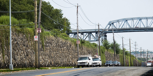
On Review Avenue, the wall of Cavalry looms. That’s the Kosciuszko bridge in the background. The cyclopean scale of Cavalry is apparent here, and behind that masonry lie the dead.

-photo by Mitch Waxman
As you continue down Review Avenue, you’ll be passing the old LIRR Penny Bridge station at the corner of Review and Laurel hill Blvd.

-photo by Mitch Waxman
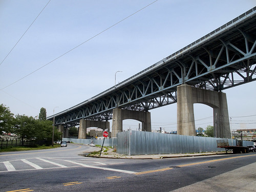
Now dear readers, this is your first revelation of a master plan behind the Newtown Pentacle. I am willing to reveal that everything is connected. This corner is where the post “Dead Ends, A short walk from Maspeth to Calvary” ends. That post picked up where “the Wrong side of the tracks, a walk in Maspeth” ended. Turn Widdershins on Laurel Hill Blvd.
-photo by Mitch Waxman
The big problem you’ll have, however, is that there isn’t really a functional sidewalk here on Laurel Hill Blvd. I’m quite used to this sort of thing at this point, so…

-photo by mitch Waxman
Commanding views of Calvary can be had here. The elevation rises, and St. Raphael’s comes into view.

-photo by Mitch Waxman
As you proceed, on the other side of the BQE will be a heavy manufacturing zone with relict housing interspersed. The area has an aura of long time municipal neglect.

-photo by Mitch Waxman
At the end of Laurel Hill Blvd, you will find a pedestrian bridge which is covered in a tightly woven chain link fence. Except for this spot, at tripod height, that was cut by some photographer in the past. The same person (same cut pattern and size) was also nice enough to cut a hole in the fence on the Pulaski Bridge.
Newtown Creek cruise
Our pals at the Newtown Creek Alliance and the Working Harbor Committee are offering a cruise up the Newtown Creek.
from the NCA website:
Newtown Creek Cruise
Saturday, September 12, 2009
Departs at 1:00 P.M. sharp from Skyport Marina, East River at 23rd Street, Manhattan.
Ticket Price $50.00 Length of Tour: Three Hours
Souvenir Tour Brochure with historical information and vintage maps. Narration by experienced historical and environmental guest speakers. Complementary soft drinks will be served.
Come aboard for an intense Newtown Creek exploration! Our comfortable charter boat will travel the length of Newtown Creek. We will also cover English Kills. The tour will pause at interesting locations for discussion. Guest narrators will cover historical, environmental, and conservation issues.The Greenpoint Avenue and Metropolitan Avenue bridges will open on our signal so we can view the furthest reaches of English Kills. Cruise runs rain or shine.
Cruise sponsor is The Working Harbor Committee. Cruise co-host is the Newtown Creek Alliance.
To order tickets click here
For more information, contact Tour Chairman Bernard Ente: bernard@workingharbor.org
I went on this last year, and am doing so again this time. Check out some photos from the trip here.
Newtown Creek Alliance meeting tonight
received from the NCA-
www.newtowncreekalliance.org
Newtown Creek Alliance
Public Meeting
Wednesday, July 29, 2009
7:00 P.M.
179 Green Street, Greenpoint
Agenda: BOA, Stormwater Grant, NCA website, and announcements.
Due to the threat of thunderstorms, The Newtown Creek Alliance will be meeting indoors on Wednesday, July 29th
Location is the Green Oaks Citizens Club, 179 Green St off of Manhattan Avenue.
By public transportation: B61, B43, B24 bus to Manhattan Avenue; Subway “G” train to Greenpoint Avenue Station, walk north on Manhattan Avenue, make right on Green.
Walk/bike from Queens over the Pulaski Bridge; west off bridge to Manhattan Avenue to Green Street.
for more info, visit the NCA site.
Dead Ends, A short walk from Maspeth to Calvary
Feel like taking a walk? I’ll show you something cool… Bring your camera- and ID
Anything you may experience, in situ, by following these walking directions is at your OWN RISK, and is offered by the Newtown Pentacle for documentary and entertainment purposes only. Remember- the rule we follow at the Newtown Pentacle is to NEVER trespass. Like Vampires, Newtownicans should wait to be invited into a house before they can do their work. Also, Please note — if something you read here is inaccurate, DO NOT BE SHY- contact me– additions and corrections are always welcome at the Newtown Pentacle.
Over Hill and Dale part 2- Newtown Creek to Calvary
So, last time, I left you on the wrong side of the tracks in Maspeth. Sorry, it can be a very nice place, and there is extremely good italian food for sale in the residential parts of Maspeth that shouldn’t be missed.
However, we are on the industrial side of town- down by the Newtown Creek- where the sins of our fathers continue to haunt modernity.
This is where we left off on July 16th- at the corner of 56th road, between 48th and 50th streets in Queens. This is an insanely dangerous patch of road running through a literal industrial backwater, so be careful. Last time we walked down the Maspeth Plank Road toward Brooklyn, today we’re going another way- tracing the course of the Newtown Creek on the Queens side for a while.

-photo by Mitch Waxman
From the vantage point above, look to your right, and you’ll see the Kosciuszko bridge. Head in that direction, which is roughly northwest and toward Manhattan. You’ll be walking down 56th rd. for a little while. The sidewalk on the Creek side is fairly non-existent, so cross the street. Watch out for trucks. Why was I here on foot, you ask?
Check out a google map of this post here. The previous Maspeth walk map can be found here.

-photo by Mitch Waxman
This walk is one that would be quite familiar to anyone living in the last century. If one was visiting a grave at Calvary, from the Brooklyn side, you’d cross Penny Bridge or the Maspeth Avenue Plank Road and head to Laurel Hill. This is a heavily industrialized section of the Newtown Creek, one which has fallen into a sort of holding pattern over the last couple of decades. Once upon a time there was a copper refinery here, one that was owned by a company called Phelps Dodge.


-photos by Mitch Waxman
At 43rd street, look to your left and see a railroad track, and the crossing over to 57th avenue. That’s Restaurant Depot on the left, the Newtown Creek is dead ahead. That’s Brooklyn on the horizon.

-photo by Mitch Waxman
from queenslibrary.org
A history of the Laurel Hill Chemical works from the beginning in 1852, from the Phelps Dodge Corporation Laurel Hill Plant Records, 1893-1983.
The following is a chronology of Phelps Dodge Corporation’s Laurel Hill Plant starting with William Henry Nichols, the man who co-founded the original chemical plant, G.H. Nichols and Company at the site in 1872; continuing to when it was purchased by Phelps Dodge Corporation in 1930; and ending in 2000 when all the structures were finally demolished.
Chronology
1852
William Henry Nichols was born to George Henry and Sara Elizabeth (Harris) Nichols in Brooklyn, New York, January 9, 1852.
1870
William Henry Nichols and his friend Charles W. Walter started making acids.
1872
To expand their acid production to sulfphurc acid and support their entrepreneurial needs William H. Nichols and Charles W. Walter, with the financial backing of William’s father George Henry Nichols, formed the G. H. Nichols and Company. The new company so named, because not only did George Henry provide the majority of the capital, but also the two men were too young to incorporate a company in New York State. During the year the company began purchasing land and building buildings in the Laurel Hill (now Maspeth) neighborhood of Queens, New York on Newtown Creek. Not only did the site offer good fishing, it afforded convenient water and rail transportation to move their raw and finished material.
1870s-1880s
Their sulphuric acid, produced from brimstone, was stronger than the industry standard upsetting their competition but greatly increasing their market share.
1880s
The company and adjoining landowner Samuel Schifflin purchased and filled in a portion of Newtown Creek.
1880s early
The company developed and installed a special burner at the plant to produce sulfuric acid from pyrites, a cheaper raw material with a stable price. They purchased a Canadian pyrite mine to ensure a steady supply of the raw material. The by-product from this process is copper matte which they sold.
1880
During this year the company built and renovated a number of buildings on the grounds including: two shops on the south side of the South Side Rail Road tracks (now owned by the Long Island Rail Road); a building built by Samuel Berg Strasser and his employees; and large additions to buildings on both sides of the railroad tracks.
1881
The company continued to enlarge and improve their plant and docks and lighters were used to ship their acids on Newtown Creek.
1884
The company purchased four acres from the Rapleye Estate on Washington Avenue (now 43rd Street) and surveyed the land for a machinery and acid manufacturing building. Construction began on the new building that extends the entire block on Washington Avenue to the railroad.
1880’s mid
A confluence of two issues, their copper matte stopped selling and the copper refinery industry’s need for a proper method for analyzing the metallurgy of copper, propelled the company to discover a new process to refine copper called the electrolytic method. This process was a commercial success producing almost 100% pure copper which they named, the famous brand, N.L.S. (Nichols Lake Substitute) Copper.
1890
This year the company built two new acid manufacturing buildings, the first of this kind in the world.
1891
William Henry Nichols renamed the company from G.H. Nichols and Company to Nichols Chemical Company. The new company was incorporated the week of January 8, to manufacture sulphuric, muriatic, nitric, and acetic acid, other chemicals, and by-products. A new four story 200 foot by 120 foot building was built on Newtown Creek.
1895
The first contract was signed by Phelps Dodge Corporation and the Nichols Copper Company to have Phelps Dodge deliver a minimum of 1,000,000 pounds of blister copper over three years. This began an economically symbiotic relationship that lasted until 1922, in which Phelps Dodge provided 90% of the blister copper Nichols Copper Company used to produce almost 100% pure copper.
1899
The first important merger of chemical companies in the United States occurred when twelve companies with nineteen plants merged to create the General Chemical Company with William Henry Nichols as chairman. The Nichols Chemical Company sold its Laurel Hill Plant and land to General Chemical for $250,000. This same year plans were filed for the erection of their, 315 feet high and 36 feet in diameter, steel chimney.
1901
On the plant grounds, General Chemical erected the tallest chimney in the United States to blow the smoke and gases from its furnace away from the neighborhood. For the past number of years neighbor surrounding the plant complained vociferously about the pollution from the factory. Only after a study found that nitric, muriatic, and sulphuric acids from the plant were destroying local cemeteries’ tombstones did the company try and alleviate the problem by building the chimney. This same year the company filed plans with the New York City’s Department of Buildings in Queens to build another 150 foot chimney, an ore breaker, a storage tank, a boiler house, and a stable.
1903
A fire, started in a building used to manufacture sulphite of copper, destroys this building and two others causing $250,000 worth of damage, to this date it was the most costly fire in Newtown.
1904
For $42,500 the company purchased from Alice H. Stebbins a major tract of land whose border was 200 feet on Locust Avenue (now 44th Street), 725 feet on River Avenue (47th Street if it extended to Newtown Creek), 825 feet on Clinton Avenue (now 56th Road), and 195 feet on Newtown Creek. That same year for $25,000 they purchased another tract from Alice H. Stebbins, Mary S. Dodge, Mary J. and William J. Schiefflin, and Eleanor J. Taft whose border was 828 feet on Clifton Avenue (46th Street if it extended to Newtown Creek), 200 feet on South Avenue (a street that was on the south side of the South Side Rail Road tracks), 755 feet on River Avenue (47th Street if it extended to Newtown Creek) and 195 feet on Newtown Creek.
1912
Another major fire occurred at the plant causing $100,000 worth of damage to a building 200 feet along Washington Avenue (now 43rd Street) and 200 feet along the Long Island Rail Road tracks.
1913
During this year the landscape of the neighborhood changed considerably with the removal of the streets, Washington, Clay, Hamilton, Fulton, Clifton, and River Avenues, on plant property between the railroad tracks and Newtown Creek. Also the railroad tracks were elevated and the remaining part of Washington Avenue was made a private road. This same year the company stated that they will be increasing their workforce from 1200 to 5000 people.
1914
The plant received 150,000 tons of copper ore.
1916
The company received approval from the New York City Board of Estimates to build a boardwalk on the stretch of land on the north side of the railroad tracks, nicknamed “Death Avenue” for the many pedestrian fatalities involving trains.
1919
The company employees 1,750 people. Along with other companies along the creek they petition the city to close the streets that were not officially opened between the railroad tracks and Newtown Creek. The petition was denied by the city and the borough because it would eliminate miles of streets and cut off public access to the waterfront.
1920
Property is expanded when the company filled in some of Newtown Creek. That same year the company was expected to be tried for illegally building a freight shed on a portion of Creek Street (57th Avenue if it extended into the plant).
1920s
In exchange for stock in the company Phelps Dodge invested $3.5 million in Nichols Copper Company’s plant modernization projects. This increased the production of copper dramatically at the plant.
1930
Dr. William Henry Nichols died. This same year, Phelps Dodge bought the Laurel Hill Plant.
1940
The following products were produced at the plant: copper, silver, gold, copper and nickel sulphates, and small amounts of selenium, tellurium, platinum, and palladium. This same year more of Newtown Creek was filled in giving the plant its final size of 35.60 acres.
1940’s
During this decade the plant began importing blister copper from Africa, South America, and scrap copper from other cities, after Phelps Dodge built a refinery in El Paso, Texas.
1956
The company constructed additions to the plant’s electrolytic tank house to increase there capacity to 35,000 tons of refined copper per month. They also increased the production of wire bars. In 1956, the plant was comprised “of a custom smelter, copper refining, and copper sulphate plant. The smelter produces blister copper from the treatment of ores, concentrates, and various kinds of scrap and copper bearing materials. The refinery treats the blister copper produced by the Laurel Hill Smelter, blister and anode copper received from others on custom basis, and high grade scrap copper. Several types of copper sulphate are produced and some refined nickel sulphate.” The plant experiences an unauthorized employee strike from January 10 – February 12.
1963
The customer smelter at the plant is permanently closed in August 1963, because the limited availability of scrap copper and other raw materials and “declining treatment toll margins among custom smelters” made the smelter unprofitable. People were laid off, the smelter was dismantled, and the parts were sold. The El Paso Refinery was able to maintain the company’s production levels.
1965
Capacity of the multiple refining system was increased by 24,000 tons per year and a gas fired vertical melting furnace was installed.
1966
The furnace for removing insulation from copper wire was “placed in limited operation,” and a new building to house equipment for the receipt and sampling of incoming materials was completed.
1967
Installation began in December of a new anode casting furnace with a waste heat boiler and a new anode casting wheel.
1971
On November 1, 1971, the company permanently shut down part of the plant’s electrolytic tank house and ceased the treatment of #2 scrap, because the facilities were built prior to 1900 and were becoming too expensive to maintain and operate. The El Paso Refinery was able to fulfill the company’s production needs.
1984
The company closed the plant permanently in February 1984, due to high costs and changing markets. The plant’s final products, which they had been producing throughout the twentieth century, were copper, silver, gold, copper and nickel sulphates, and small amounts of selenium, tellurium, platinum, and palladium. The El Paso Refinery was expected to fulfill the company’s production needs.
1986
The company sold the land to the United States Postal Service on September 1986.
1996
The postal service sued the company because they did not sufficiently clean up the site and the court ordered Phelps Dodge Corporation to buy back the property.
2001
All the buildings were torn down.


-photo by Mitch Waxman
from habitatmap.org:
Phelps Dodge – Laurel Hill Development
Address
42-02 56th Rd., Queens, NY 11378
Categories
Health, Water and Toxics
Neighborhood
Maspeth
Keywords
Phelps Dodge, copper, refinery, Superfund, Freeport-McMoRan
Owner/Occupant
Restaurant Depot now occupies the center of the site
Phelps Dodge once operated a copper refining and chemical production facility at this location. Currently Sagres Partners (a subsidiary of Galasso Trucking) owns the center of the site and has leased the space to Restaurant Depot, Boston Coach, and Galasso Trucking. The properties leased to Boston Coach and Galasso Trucking serve as storage lots for their vehicle fleets. Restaurant Depot (a subsidiary of Jetro Holdings) is wholesale food warehouse franchise.
Phelps Dodge maintains ownership of the empty rubble strewn eastern and western sections of the site, though Sagres Partners has contracted to buy these properties at a later date. These parcels will need to be capped with clean soil and pavement before they can be developed. The fifteen foot wide strip of land that runs along the border of Newtown Creek will remain the property of Phelps Dodge indefinitely, as they are responsible for maintaining the retaining wall and groundwater pumps that prevent toxic soil and groundwater from migrating into Newtown Creek from beneath the site.
Previously barring entrance to the western third of the site, this sign has now been taken down.
According to a report by Cushman & Wakefield filed with the Securities and Exchange Commission, Sagres Partners sold three parcels of land from the former Phelps Dodge site to three separate entities in 2005. A 108,900 sq. ft. parcel was sold to Radhaswamy for $8 million, a 65,000 sq. ft. parcel was sold to Montebello Italian Food Company for $5.4 million, and a 120,000 sq. ft. parcel was sold to Thai Food Company for $9.8 million. By Summer 2008 none of these entities had developed their properties and it is not known whether they still own them.
In 2007, Phelps Dodge Refining Corporation was acquired by Freeport-McMoran Copper & Gold Inc., the world’s largest publicly traded copper company, for $26 billion. Headquartered in Phoenix, Arizona, Freeport-McMoran conducts its business through its principal operating subsidiaries: PT Freeport Indonesia, Phelps Dodge, and Atlantic Copper. Freeport McMoran principally mines copper, gold and molybdenum and they have mining operations throughout the Southwestern United States, Peru, Chile, Indonesia, and the Democratic Republic of Congo.
According to an investigative report by the New York Times Freeport-McMoRan bribed Indonesian politicians and military officers and utilized the Indonesian military to threaten, harass, and kill those in opposition to their mines and mining practices. In addition, Freeport-McMoRan has dumped millions of tons of toxic mine tailings into watersheds in Indonesia thereby polluting the environment, destroying livelihoods, and poisoning thousands of people.
Location Details
The Phelps Dodge Laurel Hill Industrial Facility circa 1933. All the buildings pictured were demolished in 2000.
After 113 years of continuous industrial copper and chemical production, the Phelps Dodge Laurel Hill Works industrial facility ceased operations in December of 1983.[1] After shutting down, the property lay vacant for several years until the US Postal Service agreed to buy it in 1987 for $14.7 million. Much to their chagrin, the Postal Service soon discovered that the property was too polluted to develop leading to a 1992 lawsuit against Phelps Dodge by the US Attorney General. The suit was settled in 1997, the terms of which required Phelps Dodge to take back the property, remit the purchase price plus interest, and enter into negotiations with the NY State Department of Environmental Conservation (DEC) to arrange a clean up of the property.
Two years later, in 1999, Phelps Dodge negotiated a Consent Decree with DEC to develop a remedial action plan for the site. In 2000 the site was razed and thousands of tons of hazardous soil and sludge (contaminated with cadmium, chromium, copper, lead, mercury, petroleum hydrocarbons, PCBs and more) were hauled away and a retaining wall and groundwater pump were installed along the creek-front to prevent toxic soil and groundwater from migrating into Newtown Creek from beneath the site. Phelps Dodge spent over $30 million cleaning up the property, an amount considered inadequate by some members of the community who wanted a complete remediation of the site at an estimated cost of over $200 million.
Looking west across the site towards the Kosciuszko Bridge
In 2004 construction began on the now completed Restaurant Depot, a 75,000 square-foot wholesale food warehouse franchise. The properties just east of Restaurant Depot are used by Boston Coach and Galasso Trucking as storage lots for their vehicle fleets.
The Phelps Dodge Laurel Hill copper smelter may now be history but its toxic legacy continues to live on in the sediments and surface waters of Newtown Creek. To date, Phelps Dodge has yet to take any responsibility for, and begin removing, the toxic waste they dumped into the Creek for over a century. In February 2007, Phelps Dodge refusal to clean up the Creek lead the Attorney General of New York, Andrew Cuomo, to announce his intention to sue them for endangering the “health and the environment in Newtown Creek and portions of the adjacent shoreline”.


-photos by Mitch Waxman
Crossing the tracks (this is a city sidewalk, 43rd street and 57th avenue), i walked back into the parking lot of Restaurant Depot (which is a “public area” on private property). This was dumb, and borderline trespassing, but I was prepared to go inside the store and buy a gross of strawberries if I had to. Just a customer, Mr. Security Guard… Hopefully- this is one of the parts of Newtown Creek known for its love of photographers and its ribald sense of humor. The hair on the back of my neck was standing up so I just kept moving, and snapped my shots as I walked. I knew a security camera or two was on me and didn’t want to wear out my welcome.


-photo by Mitch Waxman
There were rail tracks here once, on the docks. Wow. Just wow.

-photo by Mitch Waxman
I kind of figure I’m not going to be seeing the Kosciuszko bridge for much longer. Its scheduled to be replaced, so I’ve been trying to record its last seasons in some detail. This is still in the Restaurant Depot parking lot, but I’m already walking a bit faster. Hidden eyes were keenly felt- sorry security guys.

-photo by Mitch Waxman
Looking back at 57th avenue, from down under the Kosciuszko bridge (DUKBO)- I turned back onto 43rd street, and hurriedly made a left onto 56th road. Continue in the western direction toward the intersection with Laurel Hill Blvd.

-photo by Mitch Waxman
High above me, the Brooklyn Queens Expressway crosses the Kosciuszko Bridge. On the easterly side of the street is a police tow yard.
For those of you reading this from outside the City of Greater New York, this is a great example of the macabre logic that the City operates under. The one tow yard in all of Queens is at one the most inaccessible by mass transit, seldom traveled to, and hard to find spots in all of Queens.
-photo by Mitch Waxman
I consider this corner- where Laurel Hill Blvd. meets 56th rd. and Calvary Cemetery to be a Long Island City, Laurel Hill, and Maspeth bordeline locus point. I’m sure this is also my personal opinion, and that I’m probably wrong. All I can say is that it feels like a border between the neighborhoods.

-photo by Mitch Waxman
On the Newtown Creek side of Laurel Hill Blvd. are a series of heavy industry sites. One or two are available for sale or development, if you’re interested in buying 200 years of ecological damage.
-photo by Mitch Waxman
When we arrive at Laurel Hill Blvd, corner of Review- the signs are clear.

-photo by Mitch Waxman
Just look across the street, where the gates of Calvary Cemetery beckon (and which we’ll be exploring in the next installment).
Or look behind you, at the sadly neglected site of the historic LIRR Penny Bridge station.


-photo by Mitch Waxman
Nazi grafiti has appeared here just recently. This sort of ugly street iconography has been appearing all over LIC and Greenpoint lately.
Not too worried about it, as New York City has a way of squashing bugs when they scuttle across the floor. These guys are going to get caught in the act, and if they are very lucky, it’ll be by the cops.
More to come.


