Archive for the ‘Photowalks’ Category
simple swains
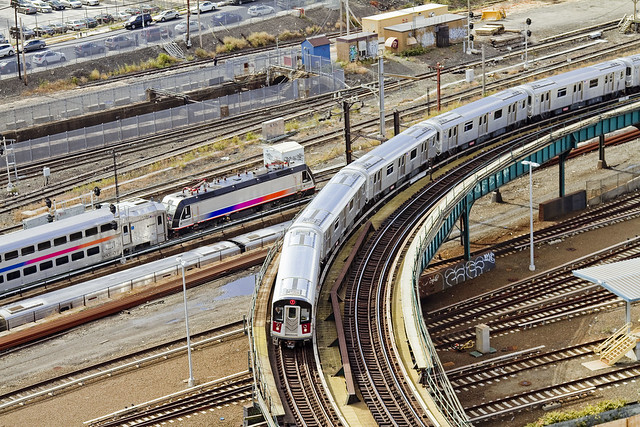
Most photogenic Subway line nomination, in today’s post.

– photo by Mitch Waxman
The elevated 7 line has become quite famous for its multitudinous delays, entire weekends wherein service is suspended, and the frustrations of the vast population who count on it as their daily conveyance to and from the Shining City from Queens. One would offer that despite all of this, it looks great, and since appearances are all that really matter under the current administration in City Hall and Albany…

– photo by Mitch Waxman
The underground lines just don’t have the same panache as the elevateds, and there are analogs for them in every major human infestation found upon the earth. The subterranean lines are dirty, dark, and the sweating concrete bunkers through which they run are the kingdoms of the rat. The first shot in today’s post emanates from a point in space roughly one hundred or so yards above the one above depicting the E line, incidentally.
– photo by Mitch Waxman
The 7 even looks good from high above, as it turns out of the Hunters Point stop into the open air over the Sunnyside Yard and heads towards Court Square. If the MTA has a “Belle of the Ball,” it’s clearly the 7 – esthetically speaking. There’s a lot to be said about the scenery at Bushwick junction as well, but the 7…

– photo by Mitch Waxman
Further east, where the so called international express heads through Sunnyside and Woodside and Jackson Heights high over Roosevelt Avenue – towards its eventual destination in Flushing – the 7 carries itself with a certain bearing and sharply appointed charm. One therefore nominates the 7 as the best looking of NYC’s subways.
Remember, it’s better to look good than to feel good, and that form always trumps function.
“follow” me on Twitter- @newtownpentacle
Upcoming Tours –
July 12th, 2015
Glittering Realms Walking Tour
with Newtown Creek Alliance, click here for details and tickets.
daytime pilgrimmage
Jackson Avenue, in today’s post.

– photo by Mitch Waxman
One has been watching the construction efforts underway at the former West Chemical site adjoining Queens Plaza for a while now. Building condominium towers in Queens Plaza is a questionable proposition, beggaring the question “who would really want to live in Queens Plaza?,” but the bigger one for me is “would you want to live on the former location of a chemical factory?.” I often remark to myself that the reason why the history of Queens is often so tough a nut to crack is the careful obfuscation of its past by the real estate industrial complex so as to preclude casual mention of the fact that so many of the new residential towers rising from Western Queens are in fact built atop such sites.
State and City officialdom call sites like these “brownfields,” which sounds a lot better than “toxic and irreversibly polluted” I guess. Just say “affordable housing” or “green infrastructure” and you’ll feel better about the whole thing.

– photo by Mitch Waxman
Brownfield remediation, or “opportunity area,” sounds a heck of a lot better at cocktail parties and let’s face it – lower Manhattan and North Brooklyn cocktail parties tend to grind into uncomfortable territory when you mention the environmental consequence of a century’s worth of industrial use. One would point out that at least the “powers that are” aren’t planning on putting a school on top of the old West Chemical site, but that brings up the uncomfortable subject of the infrastructure required to support a residential population being inserted into a former industrial zone, and the lack thereof, so that’s best avoided as well so as to not make the bond brokers skittish and derail the program.
It will not be conducive, condo sales wise, to mention all of those closed FDNY units or the frankly astounding conditions encountered at the centuried Queensboro or Ravenswood NYCHA projects, nor where the nearest hospital emergency room is located.

– photo by Mitch Waxman
The old “chickens coming home to roost” adage will likely be punching Western Queens in the nose some time in the late 2020’s – by my estimate. That’s when our trains will be running at (instead of near) capacity, our lack of school desks and hospital beds will be most apparent, and when the new populations installed in these former industrial corridors begin to organize – politically speaking. One wonders if these new populations will vote in as reliable and “party loyal” a fashion as the current residents do. Will the 20’s roar, or howl, for the Democrats?
The folks who can afford the so called “affordable housing,” rising from these “brownfields,” will they vote for a Democrat party candidate and continue the rule of the “Queens Machine” – or will they support somebody else who is a little more in tune with them socioeconomically? Only time, and a roll of the political dice, will tell.
“follow” me on Twitter- @newtownpentacle
Upcoming Tours –
July 12th, 2015
Glittering Realms Walking Tour
with Newtown Creek Alliance, click here for details and tickets.
only crawl
Astoria, in today’s post.

– photo by Mitch Waxman
Just the other night, while hanging out at my local pub here in the southern end of Astoria, some rough fellow accosted one with the usual “hey, what are taking pictures of?” thing. Bellicose, the gentleman began to advise me that I should spend my time photographing the skyline of Manhattan because “no one cares about Queens.”
He was rather insistent about this.

– photo by Mitch Waxman
This is kind of rallying cry for me, this “no one cares about Queens” thing, and it’s bothersome to have to argue about it with some guy who – as it later turned out – had a largish back tattoo whose motif included a shoulder to shoulder swastika.
I’m all for political expression of course, but a Nazi in Astoria?
Conversation with amiable bartenders over the weekend revealed that there seems to be a small population of like minded individuals in the neighborhood. They’ve actually had to reprimand one fellow who liked to read passages from “Mein Kampf” out loud at the bar.
“Really?” was all I could say.

– photo by Mitch Waxman
It’s not strange that racists and other adherents to rather ugly philosophies can be found in Astoria. We’ve got Jihadi sympathizers on the ass end of Steinway Street, and those Greek “National Front” guys are here as well -heck- a few years ago I even ran into a small group of actual card carrying Bolsheviks who opined that the revolution was nigh. “Diversity” includes nut jobs and jerks too, it would seem.
Thing is – If you’re a racist, “politically” a racist that is, Astoria probably ain’t the sort of place you’re going to want to live in. It will be exhausting for you to merely identify or classify the human infestation hereabouts, let alone espouse a specific grievance about all the groups who are living and working here. We have everybody from Egyptians to Eskimos, Thai to Tibetan, Irish to Indian. There’s normal human prejudice and frictions encountered occasionally when these wildly different cultures rub up against each other, but Nazi’s?
How retro.

– photo by Mitch Waxman
Historically speaking, Queens has a rather checkered past on this subject. Members of what we would call the American Nazi party – the so called German American Bund – were rather active in the years leading up to the Second World War here in Queens (and especially so in Ridgewood and Bushwick).
These neighborhoods hosted a rather large German population back then, who referred to their communities in New York City as “Kleine Deutschland” and the “bund” was usually in tune – politically speaking – with their distant homeland. All of that fell apart during the Second World War and the American Nazi’s became associated with extreme elements of the Ku Klux Klan, and prison gangs like the Aryan Nation.
Hey, when you grow up Jewish, you develop a certain sensitivity to this sort of thing. Swastika bad.
“follow” me on Twitter- @newtownpentacle
Upcoming Tours –
July 12th, 2015
Glittering Realms Walking Tour
with Newtown Creek Alliance, click here for details and tickets.
quaint fusion
Shots from a recent boat trip to the Gowanus.

– photo by Mitch Waxman
A few weeks back, I conducted the Working Harbor Committee Newtown Creek boat tour, which was followed by an excursion to the Gowanus Canal. Both boats were solidly packed with harbor enthusiasts, curious explorers who welcomed the opportunity to visit some of NY Harbor’s less well known spots. Obviously, I didn’t get any shots on the Newtown Creek tour (my curse) but since my pals Joseph Alexiou and Eymund Diegel were handling the narration on the Gowanus trip, I was able to have some #superfun for once.
Pictured above, the push boat Emerald Coast in Gowanus Bay.

– photo by Mitch Waxman
John Quadrozzi Jr. was also onboard, and he jumped onto the microphone once or twice during the voyage. Seeing as how JQJr. actually owns big giant chunks of Gowanus Bay, he had a few things to say about this and that – offering the Working Harbor audience insider insights from his unique point of view.
One of the “this’s” Mr. Quadrozzi discussed was his Grain Terminal building, and one of the “that’s” was the ship Loujaine – both pictured above.

– photo by Mitch Waxman
I do like the point of view one is offered by the entrance to the Gowanus Canal, don’t forget that Gowanus Bay is kind of a separate banana from the Gowanus Canal, whose navigable entry point is found at the Hamilton Avenue Bridge.
That hulking monstrosity you’ll notice lurking above the bridge, in all its neighborhood blighting glory, is the Gowanus Expressway.

– photo by Mitch Waxman
Our vessel’s passage required the Hamilton Avenue Bridge to open, and while we waited for the redoubtable employees of the NYC DOT to actuate its mechanisms, I noticed this bit of former maritime industrial glory sitting on the poison shoreline. First thought that entered my head when I saw it was “this is the dreidel of the gods.” For those of you reading this who are “goyem,” a dreidel is that little Jewish spinning top thing with the Hebrew lettering on it.

– photo by Mitch Waxman
The HMS Liberty, observed as it passes by the SimsMetal facility and a windmill on the southern shore of Gowanus Bay. Liberty is a tugboat, as opposed to the Emerald Coast found in the first shot of today’s post – which is a push boat. Both are towing vessels, of course, and tug versus push is pretty descriptive of the different approaches to the mission which they’re engineered for.
“follow” me on Twitter- @newtownpentacle
Upcoming Tours –
June 20th, 2015
Kill Van Kull Walking Tour
with Brooklyn Brainery, click here for details and tickets.
far within
A bright, light, sunshiney day, in Today’s Post.

– photo by Mitch Waxman
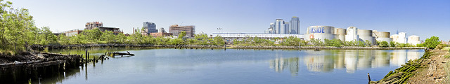
Recently, the Federal NOAA agency placed a plaque at Bushwick Inlet’s U.S.S. Monitor Museum site, signifying the launch site of the United States’ first ironclad war ship from the spot in Greenpoint. One made it a point to arrive early, there was an event planned which involved dignitaries speaking and children singing, and take a bit of time to get “artsy – fartsy” with the camera and grab some shots.
– photo by Mitch Waxman
The one above is a stitched panorama, representing around 200 degrees of view. Just to the right of center are some of the big condo buildings in Williamsburg, and at far right are the tanks of Bayside Fuel.

– photo by Mitch Waxman
That’s Franklin Street on the other side of the fence, btw, behind an overgrown fence line which one didn’t explore except with a zoom lens.

– photo by Mitch Waxman
There was, indeed, a duck of some kind there.

– photo by Mitch Waxman
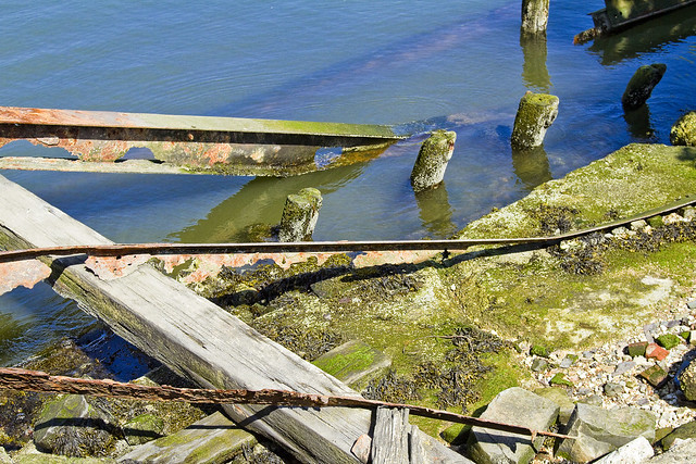
Rotting timbers found in the littoral zone, which look quite a bit different than the ones you’ll find along my beloved Newtown Creek. These are green and teeming with life, as the East River is actually quite a bit cleaner here than in its northern tributary.

– photo by Mitch Waxman
There were lots of rusty bits sticking up out of the ground, but heck – this used to be Continental Iron Works after all.

– photo by Mitch Waxman
Continental Iron Works, in addition to building the Monitor, also fabricated the caissons of the Brooklyn Bridge here.
– photo by Mitch Waxman
Most of this stuff doesn’t date back to the 1860’s, obviously, there’s a large MTA warehouse and workshop on the landward side and this was the industrial coast of North Brooklyn. Nothing laid fallow here until pretty late in the game – the 1960’s at the very earliest. The experts on this site are George and Janice from the Greenpoint Monitor Museum, who can tell you all about it here.

– photo by Mitch Waxman
My interest in Bushwick Inlet is Newtown Creek oriented, of course. The historical definitions of the wetlands surrounding my beloved Creek always mention Bushwick Creek (here) to the south, and Sunswick Creek (Hallets Cove) to the north.
The area between Newtown and Bushwick Creek was called “the Cripplebush,” which is a fun fact.

– photo by Mitch Waxman
Looking past the mouth of Bushwick Inlet, one finds the Freedom Tower, rising from the LeCorbusier inspired NYCHA housing which rings the Shining City.
“follow” me on Twitter- @newtownpentacle
Upcoming Tours –
June 20th, 2015
Kill Van Kull Walking Tour
with Brooklyn Brainery, click here for details and tickets.
