Archive for the ‘Pickman’ Category
ordinary interpretation
First Calvary Cemetery, in today’s post.

– photo by Mitch Waxman
It’s been a while since a post about my favorite place in Queens has been offered at this, your Newtown Pentacle. For those of you who have recently arrived, Calvary was the official burying ground of the Roman Catholic Church for about a century. There are four sections, which contain more than six million interments, and the oldest section (First Calvary) was consecrated in 1848 by the Archbishop “Dagger” John Hughes. It adjoins the lugubrious Newtown Creek, a century of its expansion has largely consumed a 19th century community called Blissville, and it is the final resting place for mobsters, governors, and the rightful king of Ireland.
Calvary Cemetery is a movie star, having provided Hollywood with the setting for funereal scenes in multiple films. Fictional characters buried here in the movies range from Don Corleone in the Godfather to both Uncle Ben and Gwen Stacey in Sony’s Spider Man franchise. Bruce Wayne’s parents are buried here as well.

– photo by Mitch Waxman
Calvary Cemetery is a built environment, the crown of what was once known as Laurel Hill. A broad slope rises from the former swamps found along Northern Blvd., gaining altitude and moving through what is now called Sunnyside, and cresting at the former family farm of the colonial era Alsop family. Laurel Hill’s altitude then drops precipitously to the flood plains of Newtown Creek. In the 1850’s and 60’s, Church laborers extensively remodeled Laurel Hill to fit its mission, creating a private drainage system and removing millions of tons of top soil. By the late 19th century, Calvary had become a major destination for mourners from the largely catholic population of lower Manhattan and it was served by both ferry and trolley lines. Along its borders – road houses, saloons, and hotels were found.
That is, until the age of industry really kicked into gear along the Newtown Creek.

– photo by Mitch Waxman
One of Calvary’s neighbors was a company originally called General Chemical, but which is better known today as Phelps Dodge. General Chemical manufactured sulphuric acid (amongst other things) and Phelps Dodge, which was engaged in the copper business, acquired General Chemical at the start of the 20th century. They would use the acid produced here to free valuable metals from the ore it was laced into. General Chemical was not popular with its neighbors, due to the effluent which would drift out of its smoke stacks.
According to anecdotes from the time, coming from both Blissville and the town directly east of it – Berlin (now known as West Maspeth) – this effluent would wither gardens, ruin laundry hung out to dry, and in the case of Calvary Cemetery right next door – dissolve the tombstones.

– photo by Mitch Waxman
Marble is particularly vulnerable to acidification, and visibly rots away when exposed to ph’s high enough to be classified thusly. Pictured today is an 1866 monument dedicated to a person named “Mary Kiernan.” This monument bears the classic “rot” and weathering exhibited by acid damaged marble. Touching the stone, you’d pull your hand away and discover a sandy grit sticking to your fingers.

– photo by Mitch Waxman
General Chemical found itself in a real pickle on this issue, as “public relations” hadn’t been invented yet, and the Church was pressuring the largely Irish political establishment of Tammany Hall to do something to help them. The company’s response was to build the tallest smoke stack to be found anywhere in the United States (at the time), with the goal of keeping the noxious emanations of the plant as far away from the ground as possible. They also planted a series of vegetable gardens in Blissville and Berlin, and began inviting reporters to witness the thriving patches of cabbage growing within throwing distance of their acid factory.

– photo by Mitch Waxman
Here’s the inscription on the Kiernan monument, and as you’ll observe, most of the fine detail in the carving has the appearance of melted ice cream. Like General Chemical, and so many other of the great corporations which once distinguished Newtown Creek – Phelps Dodge has come and gone.
Of all that was here along the Creek in the decade leading up to the Civil War, only the genuine antiquity that is Calvary Cemetry remains.

– photo by Mitch Waxman
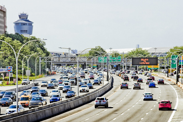
Across the cemetery, you’ll notice statuary bearing similar damage. The main source of acidification today comes from the exhaust of automobile traffic, as it mixes with atmospheric humidity, which eats away at the stone. Calvary Cemetery is bounded by the Long Island Expressway on its northern side, and the Brooklyn Queens Expressway is found less than a half mile to the east. Greenpoint Avenue, and Review Avenue are local truck routes which host extremely heavy traffic.
All told, nearly a half million vehicles a day pass by the cemetery every single day of the year, here in the Netwon Pentacle.
“follow” me on Twitter- @newtownpentacle
Upcoming Tours –
August 8th, 2015
13 Steps Around Dutch Kills – LIC Walking Tour
with Atlas Obscura, click here for details and tickets
evil design
Getting around town, in today’s post.

– photo by Mitch Waxman
A humble narrator’s antipathy towards entering the rat infested bunkers of sweating concrete that underlie the megalopolis has been fully explored in prior posts at this, your Newtown Pentacle. What are you going to do, though? There’s really only one truly economical way to get around in our city, and the subway is it.

– photo by Mitch Waxman
You could drive, I suppose, but one such as myself lives a mere three stops out from the City center, and cannot imagine bearing the costs and pain in the neck that maintaining an automobile would entail. My solution has always been to rent a car when I need one, which is not that often. It’s an expensive caprice, but no where even close to paying annual insurance, gas, and paying for the inevitable parking tickets.

– photo by Mitch Waxman
One has been making a dedicated effort to use the MTA bus system in the last year, as many of the places which I’m headed for in Queens are not served by the Subway system (or if they are, I have to loop through all of Manhattan to get there from Astoria). For instance, getting to Ridgewood, a distance of less than 6 miles from Astoria, would necessitate a 50 minute ride on the M which would visit most of Manhattan and a significant chunk of North Brooklyn.

– photo by Mitch Waxman
Far and away, my favorite form of transit are the ferries, and in particular the giant orange ones. East River Ferry has ironed out a lot of the kinks in their service in the last year, btw, and there’s now a smart phone app which publishes a schedule and anticipated times of arrival at the various landings. You can also purchase tix via the app. The big orange boat is free, incidentally, and is amongst other things – the most popular tourist destination in NYC.

– photo by Mitch Waxman
One would enjoy using the rich man’s preferred mode of transit, if only as a diversion, but this mode of transportation is ridiculously expensive – something like $2,000 per hour.
The best way to see NYC is on foot, of course.
This Sunday, I’ll be leading a walking tour of the eastern side of Newtown Creek for Newtown Creek Alliance, btw. Tix are still available, see the links below for more info.
“follow” me on Twitter- @newtownpentacle
Upcoming Tours –
August 2nd, 2015
The Insalubrious Valley of the Newtown Creek – Bushwick & Mapeth Walking Tour
with Newtown Creek Alliance, click here for details and tickets.
August 8th, 2015
13 Steps Around Dutch Kills – LIC Walking Tour
with Atlas Obscura, click here for details and tickets
without warning
A fairly novel spot found in north western Queens, in today’s post.
– photo by Mitch Waxman
As mentioned last week, one enacted a “bat out of hell” protocol when Our Lady of the Pentacle allowed me a brief furlough from a kitchen renovation project here at HQ. My perambulation was committed in an easterly direction along Northern Blvd., which ceases to be pedestrian friendly at 114th street. A northerly turn found me at the intersection of Astoria Blvd. and Ditmars, and since it was a warm afternoon, tree lined Ditmars was the route I elected to take back towards the rolling hills of almond eyed Astoria.
When you say “North Western Queens,” one thinks of jails and airports and power plants and stadiums, and as pictured above – the barrier parkway known as the Grand Central.
There is, however, something else found hereabouts.

– photo by Mitch Waxman
Along Ditmars Blvd., this inviting pedestrian path beckons. Signage found at its intersection informs that this is NYC Parks Department property, and a part of the Flushing Meadows Corona complex.

– photo by Mitch Waxman
The Worlds Fair Marina is noticed first, a boat basin servicing a fleet of privately owned pleasure craft.

– photo by Mitch Waxman
Then, looking to the west and LaGuardia Airport, you observe a part of the Flushing Bay Promenade. Asking around at my local bar, none of the native Astorian lifers even knew this park existed.
Perhaps it’s better known in East Elmhurst, which is the community that hosts it, but my Astoria peeps professed complete ignorance on the subject.

– photo by Mitch Waxman
To the east, something that every Queensican is intimately aware of will be found, the home of our lamentable Mets baseball team at Citifield. Just beyond the stadium are the main sections of Flushing Meadows Corona Park.

– photo by Mitch Waxman
To the west is LaGuardia Airport, and this spot along Flushing Bay was a great location from which to observe the goings on thereabouts.
The NYC Parks Dept. makes this page available at their website, describing the history and rather recent creation of the Flushing Bay Promenade, which is connected to the presence of a large NYC DEP “Combined Sewer Outfall” gray infrastructure project nearby.

– photo by Mitch Waxman
At the western edge of the park was a somewhat natural shoreline, and lots of birds were observed flitting about. Luckily it was high tide when I was visiting, as anyone who has driven along the Grand Central Parkway can describe the sickening rotten egg smell which out gasses from the mud flats here at low tide.

– photo by Mitch Waxman
A smallish homeless camp was observed right along the walls of LaGuardia Airport, and there were makeshift shanties and fabric tents arrayed amongst the tree line. I didn’t venture into the area any further than as indicated in the shot above, however, as I avoid taking shots of residences no matter what their status is.

– photo by Mitch Waxman
The high speed road known as the Grand Central Parkway, pictured above as seen from within the Flushing Bay Promenade, was constructed in the 1930’s. Part of the Triborough Bridge build out, the Grand Central was widened in the post WW2 period to its current dimensions. Another project from the House of Moses.
Robert Moses was a very clever man who mastered the bureacracy of State, City, and Federal highway systems – earning himself the appellations of both “Master Builder” and “Power Broker.” Moses held near absolute power over highway and bridge building, as well as public housing and parks, for nearly forty years before Governor Nelson Rockefeller ousted him from government in 1974.
The NYC we all know is the City that Moses built.

– photo by Mitch Waxman
As with all things government, specificity is key to understanding a thing. The reason that it’s the Grand Central “Parkway,” instead of highway or expressway, are the grassy and wooded medians that run alongside it. Since these medians are titular “parklands,” Moses had broader powers of eminent domain when claiming and remodeling the area to drive a high speed road through it.
Moses also built LaGuardia Airport, incidentally.
“follow” me on Twitter- @newtownpentacle
Upcoming Tours –
August 2nd, 2015
The Insalubrious Valley of the Newtown Creek – Bushwick & Mapeth Walking Tour
with Newtown Creek Alliance, click here for details and tickets.
August 8th, 2015
13 Steps Around Dutch Kills – LIC Walking Tour
with Atlas Obscura, click here for details and tickets
past imagining
Wandering, wandering.

– photo by Mitch Waxman
Last week, a brief interval allowed me to escape from HQ, where a kitchen renovation has been underway for the last couple of weeks. My landlord, distressed by my reports of rodentine occupation in the so called “wet wall” found behind the 1970’s era cabinetry affixed to it, sent in the Croatians. Said Croatians have been doing a brilliant job, and are nearing completion of the project after two weeks of work (which is bit of a miracle itself here in Astoria), but I’ve been stuck here keeping an eye of things and ensuring that Zuzu the dog doesn’t wander into a tile saw or something.
Luckily, Our Lady of the Pentacle invoked a “work from home day” last week, allowing me the freedom to go on one of those ridiculously long walks across Queens for which I am sort of known. This time around, my path wasn’t towards the East River, nor Newtown Creek – instead, I headed east along Northern Blvd.

– photo by Mitch Waxman
The first thing which caught my eye was, as always, something Robert Moses left behind – the Brooklyn Queens Expressway. This is literally the “Northern Blvd. exit” by the way, which empties the highway onto the local streets in a confusing series of curved and badly marked lanes. As with all things Moses, “pedestrian friendly” is at best an afterthought. The BQE does serve a purpose for me, however, as a geographic reference point.
It’s easy to know which community of Western Queens you’re moving through when on the neighborhood’s “main drag.” You have no doubt about whether it’s Jackson Heights or Woodside when you’re on Roosevelt Avenue, for instance. Same thing with Sunnyside, Woodside, or LIC. There’s a distinct “feel” to these neighborhoods.

– photo by Mitch Waxman
Northern Boulevard, however, was built as a high volume road for automobiles. Most of what you’ll find along its length, from its transmogrification at 31st street from Jackson Avenue to Northern Boulevard all the way to its titular end of pedestrian friendliness at 114th street in Corona (and yes, I know route 25a continues all the way to Suffolk County) are automobile related businesses and chain store restaurants. Northern gets a bit more residential when you get out east into the 80’s, 90’s, and so on but it’s still pretty automobile focused. We’ll talk about that in subsequent posts that spawn out of this particular walk.
The funny thing is, of course, that a few phone calls were made to friends who grew up in Queens to double check my impressions of “where I was” while developing this set of shots. You can’t trust the real estate people, who will try to describe parts of East New York as Williamsburg if you let them.
As I said to Hank the Elevator Guy – “so if I’m on 78th and Northern…” There was some debate amongst my Queens natives on that one, incidentally, as to whether that particular area counts as Jackson Heights or Elmhurst. Consensus was achieved when several parties said “it depends on which side of Northern you’re on.”

– photo by Mitch Waxman
The fellow pictured above, who made the absolutely terrible decision to stand on the off ramp of the BQE in what is definitively Woodside (62nd and Northern), bore a bit of signage adjuring passing motorists to toss him a few handfuls of loose change. A sign of the times, this fellow actually is. Emblematic of the current Mayoral admistration’s anitipathy towards the enforcement of “quality of life” regulations which have distinguished our municipal experience over the last twenty years. I’m sure he will be replaced shortly by some guy with a squeegee and a bottle of windex. I’d vote for the squeegee guy over our current First Citizen in a heartbeat. I’d also vote for a parakeet just to see the First Citizen sent packing back to Park Slope.
This walk, an escape from the domestic construction project mentioned at the top of the post, was a bit mad btw. One emulated the proverbial “bat out of hell” and covered quite a bit of ground. Starting at Woodside Avenue and Northern Blvd., I walked east along Northern to 114th and then headed Northwest along Ditmars into East Elmhurst and then southwest back into Astoria.
Many interesting things were observed, which will be offered and described in subsequent posts at this – your Newtown Pentacle.
“follow” me on Twitter- @newtownpentacle
Upcoming Tours –
July 26th, 2015
Modern Corridor – LIC, Queens Walking Tour
with Brooklyn Brainery, click here for details and tickets.
As detailed in this recent post, my camera was destroyed in an accident.
For those of you who have offered donations to pay for its replacement, the “Donate” button below will take you to paypal. Any contributions to the camera fund will be greatly appreciated, and rewarded when money isn’t quite as tight as it is at the moment.

which swelled
Random sightings in Astoria.

– photo by Mitch Waxman
The other day, whilst waiting for the bagel shop guy to assemble a sandwich for my consumption, this pile of cigarette refuse was observed. One was impressed not just by the quantity – this has to represent around $75-80 worth of coffin nails as currently priced in NYC – but by the relative tidiness and self contained nature of the refuse. The “Vision Zero” branding on the muni meter receipt just brought it home for one such as myself.

– photo by Mitch Waxman
Over on Astoria’s Broadway, nearby Crescent Street, one of those Chinese owned dollar stores had a display of plastic flowers arrayed upon the pavement. Other offerings included off brand backpacks and those wire shopping carts which we all use for transporting bags of laundry to and fro, but the patent artificiality of the flowers transfixed me. It was actually a bit of a challenge to capture how truly saturated their colors were.

– photo by Mitch Waxman
Near Astoria Boulevard’s intersection with 21st street, this pentagram graffiti was found on the back door to a fairly ancient commercial building. When I spotted it, a loud exhortation bubbled out of me and “yeah, Satan!” was uttered. This caused no end of concern to the old Greek lady sitting on her porch across the street. Accordingly, one scuttled away and brisk perambulation carried me in a generally northern direction.
I’ve been chased through the neighborhood by a group of angry Greek women before, and do not intend on suffering through that sort of thing again.
“follow” me on Twitter- @newtownpentacle
Upcoming Tours –
July 26th, 2015
Modern Corridor – LIC, Queens Walking Tour
with Brooklyn Brainery, click here for details and tickets.
As detailed in this recent post, my camera was destroyed in an accident.
For those of you who have offered donations to pay for its replacement, the “Donate” button below will take you to paypal. Any contributions to the camera fund will be greatly appreciated, and rewarded when money isn’t quite as tight as it is at the moment.
