
Nichole East posted this video on Flickr documenting an exorcism performed by her neighbors last week. She also snapped the above photo of the friendly note she left them. (Thanks, Greg Long!)
Altissima quaeque flumina minimo sono labi

– photo by Mitch Waxman
It’s what the gulls say.
As described in earlier posts, my mother has been ill, which has necessitated travel to and from… Staten Island… on the part of your humble narrator to safeguard her interests. I won’t bore you with the horrible realities of geriatric care in the City of Greater New York, but will instead share the way that I’ve passed the time while traveling back and forth from Astoria to… Staten Island.
Luckily, a fairly straight forward course exists, the R line connects western Queens with Manhattan, and its last stop in the Shining City is South Ferry- where the Staten Island Ferry docks at the Whitehall Terminal.
from nyc.gov
The following New York City Department of Transportation (NYCDOT) Staten Island Ferry Passenger Rules of Conduct shall be adhered to by all passengers to ensure the safety of the public and all employees.
1. No disorderly conduct or behavior that may be deemed unsafe or disruptive.
2. No littering. Place all trash and garbage in the receptacles provided.
3. No spitting or creating of any other unsanitary condition.
4. Lying down on seats and benches within the terminals and vessels is prohibited.
5. Feeding of any animal within the ferry terminals or on any vessel is prohibited.
6. Smoking is prohibited onboard the vessels and within all enclosed spaces in the terminals. Smoking is allowed only in designated open areas.
7. Distribution or posting of any literature or advertisements without a NYCDOT permit is prohibited.
8. Unauthorized carrying of a firearm or weapon within the terminals or on the ferries is prohibited.
9. No person shall skateboard, roller skate or ride a bicycle, scooter or any other vehicle or device (except a wheelchair required for transit) on or through any part of the terminals or ferries. Bicycles and non-motorized scooters must be walked through the terminals and ferries and board the vessel via the lower level.
10. Commercial use of video, photography or audio recording equipment without a NYC permit is prohibited.
11. Playing any audible device without the use of earphones is prohibited. Audible devices include but are not limited to radios, game devices and video/audio playback devices.
12. Pets, other than service animals as defined by the Americans with Disabilities Act, are not allowed in the facilities and/or onboard the ferry boats, unless they are caged and/or muzzled.
13. Destruction, graffiti, or marking of any facility or vessel is prohibited.
14. During an emergency all passengers shall follow the direction of NYCDOT facility personnel or vessel crew members.

– photo by Mitch Waxman
The short trip across NY Harbor passes the Narrows and the nearby Kill Van Kull which provide ocean going craft with a pathway to the titanic facilities of Port Elizabeth Newark. On the Staten Island side, the Ferry docks into the St. George terminal.
A vast industry is at work on the water though, wholly visible in the weird and dynamic lighting generated by that queer luminance filtering through the humid valences which typically occlude the burning thermonuclear eye of god itself during seasonal transitions from winter to spring here in the City of New York.
from wikipedia
The St. George Ferry Terminal is one of two terminals of the Staten Island Ferry with the other being South Ferry which is located on the southern tip of Manhattan near Battery Park. The Staten Island Ferry runs 24 hour service between both terminals.
Staten Island Ferry terminal at South Ferry in Lower Manhattan
Today the Staten Island Ferry annually carries over 19 million passengers on a 5.2 mile (8.4 km) run that takes approximately 25 minutes each way. Service is provided 24 hours a day, every day. Each day approximately five boats transport about 75,000 passengers during 104 boat trips. Over 33,000 trips are made annually.
During rush hours, ferries usually run every 15 and 20 minute intervals, decreasing to 30 minutes during the mid-days and evenings. During very late or early morning hours (the midnight hours) a ferry is provided once every 60 minutes. During the weekends ferries run every 30 and 60 minutes. In November 2006, additional ferries running every 30 minutes were provided during the weekend morning hours – the most significant change in the ferry schedule for about 3 decades.

– photo by Mitch Waxman
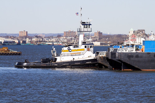
The Staten Island Ferry moves at a good speed, generating airborne turbulence that attracts avian opportunists. Floating in the boreal slipstream of the great ship, gulls and other harbor entities accompany weary citizens on their cross harbor commute. The commuters entertain themselves with magazines, newspapers, and gadgets while out on the water- where a 24 hour heavy industrial work schedule is maintained. Pictured above are the tugs Frederick E. Bouchard and Linda Moran.
From his first voyage at eleven years of age as a cabin boy on a sailing ship bound for China, Captain Fred Bouchard knew that shipping would be his life. By 1915, he was the youngest tugboat captain in the Port of New York.
NY Times Article from June 8, 1900
Woman and Child Saved (by Captain Bouchard)
On July 30, 1916, while on watch of the tug C. GALLAGHER of the Goodwin, Gallagher Sand Co., Captain Bouchard witnessed the infamous Black Tom Explosion, which detonated $22 Million dollars worth of WW I munitions. Always one to set out to accomplish what few others could, he took his tug from the Long Dock at Erie Basin in Brooklyn and headed for New Jersey. Amongst continuing explosions, which blew the glass panes and lights out of his tug, he worked to rescue the 4,000-ton Brazilian steamer TIJOCA RIO, and the schooner GEORGE W. ELEZY, of Bath, ME. Later the US District Court awarded the Captain a salvage award and an additional award for personal bravery, which totaled $9,000. He quickly invested the salvage award to create his own company, Bouchard Transportation Company, which was incorporated in 1918.

– photo by Mitch Waxman
The enormous orange car carrier cargo ship is being guided by the Miriam Moran, a 3,000 hp tug. The cargo ship, Tancred, is operated by the Wallenius Wilhelmsen company, and is just the latest ship of the historic Norwegian-America Line to bear that name. Maritime nomenclature refers to Tancred as a RORO- or Roll on and Roll off cargo ship.
from theshipslist.com
The company Wilh. Wilhelmsen was founded in Tønsberg in 1861 by Morten Wilhelm Wilhelmsen as a brokering and ship chandlering company and eventually became the largest Norwegian shipping company. In 1865 he entered shipowning when he purchased a share in the barque MATHILDE. The company’s first steamship, the TALABOT was purchased in 1887.
In 1901 the company progressed into liner services and in 1911 in partnership with Fearnley & Eger, established the Norwegian Africa and Australia Line. At the same time, the two companies took over the Norway Mexico Gulf Line.
By 1914 The Straits, China and Japan were added to the schedule and by this time the company was trading world wide. Although mainly a cargo company, many of their ships had accommodation for up to 12 passengers. In 1913 the company acquired it’s first oil tanker and by 1918 owned ten of these ships and had moved their operations to Oslo. In the inter war years, the liner trade was greatly expanded and the tankers and tramp ships gradually sold.
In 1920 Wilhelmsen took over the sole management of the Norwegian Africa and Australia Line and the Norway Mexico Gulf Line. In World War two, 26 of the company’s ships were lost, but were rapidly replaced after the war.
In 1969, Wilhelmsen, Fearnley & Eger and A. F. Klaveness jointly established Barber Lines. Later Wilhelmsens took over ownership and in 1975 established Barber Blue Sea Line jointly with Brostroms and Blue Funnel Line of Liverpool. In the 1970s, the company diversified into the offshore oil industry but sold their interests in this activity in 1995. The same year, Wilhelmsen’s acquired the Norway America Line. In 1999, The company formed a joint company with Wallenius of Sweden to operate both companies under the name of Wallenius Wilhelmsen Lines and still trades today.

– photo by Mitch Waxman
Tancred is capable of transporting thousands of automobiles in one ocean going structure. It was built at the Sumitomo Heavy Industries shipyard in Japan in 1987, has a gross tonnage (fully loaded) of 48,676, and is some 195.05 meters long. That’s 639.927822 feet, roughly one eighth of a mile. The fact that Tancred is riding so high in the water suggests that it has disgorged its cargo at the nearby Port of Newark.
from wilhelmsen.com
The PCTC (Pure Car and Truck Carrier) MV Tancred is one of three vessels built by Sumitomo Heavy Industries, Japan and she was delivered in April 1987. The vessel is specially suited for cars and trucks but she has also flexibility to carry other project cargo. MV Tancred has a total capacity of 5930 cars (RT43) or 552 trucks. Her sisterships are MV Tai Shan and MV Takara. The ship is built to the class of DNV (Det Norske Veritas) with the following designations DNV +1A1, Car Carrier MCDK, PET EO.

– photo by Mitch Waxman
Miriam Moran, of course, is operated by Moran Towing and was built at the McDermott Shipyard in LA in 1979.
from fundinguniverse.com
The Moran Towing Corporation, Inc. is the largest privately owned tugboat company operating on the East Coast of the United States and a leader in oil and dry-bulk barge transportation. A family-owned business for more than a century, the company was purchased in 1994 by a group of investors headed by Paul R. Tregurtha and James R. Baker, who were also principals in the Mormac Marine Group and the Interlake Steamship Company.
Although it was incorporated in 1905, Moran Towing traces its origins to 1855, when Michael Moran, a 22-year-old immigrant from Ireland, used money he saved as a muleskinner on the Erie Canal to buy a barge. Five years later, after acquiring several more barges, Moran headed to New York City, where he set himself up as a tugboat agent. In 1863, he paid $2,700 for half interest in the Ida Miller, a 42-ton, steam-driven harbor towboat.
By the 1880s, Moran Towing was an established company serving the busy New York Harbor, and in 1883, Michael Moran was asked to serve as commodore of the tugboat division for the 1883 ship parade celebrating the centennial of the British evacuation during the Revolutionary War. After the parade, Michael Moran continued to use the title “Commodore.” His son, Eugene F. Moran Sr., then 11 years old, recalled in Tugboat: The Moran Story, “Nothing, since he established himself in New York, gave him a greater sense of accomplishment than the name of commodore…. He had become a personality among seafaring men.” Almost 70 years later, The New Yorker would describe Michael Moran as a “bold but pious” man who “often found it necessary to use a fleshly approach in refining the general spirit. Upon finding a couple of his subordinates drunk and brawling, he would seize them and start banging their heads together, meanwhile crying out admonitions mixed with Scripture.”
Michael Moran also started the company tradition of naming tugboats after family members in 1881, when he christened the Maggie Moran, the first tug built for Moran Towing, for his first wife, Margaret. About the same time, he began the tradition of painting a block letter “M” in white on the black smokestacks of his tugboats.
When Moran Towing was incorporated in 1905, Michael Moran, then 73, was president of the company, and Eugene Sr., then 33, was vice-president. That same year, Moran Towing set a record for long-distance hauls when it towed a barge from New York to San Francisco, 13,220 miles around Cape Horn. Michael Moran died a year later and was succeeded as president by his son, who quickly developed a reputation of his own.

– photo by Mitch Waxman
As mentioned, the Staten Island Ferry does not dally, and one must not prevaricate when photographing onboard. The whole journey across the harbor takes approximately 25-30 minutes and is currently free.
from siferry.com
The Staten Island Ferry provides 20 million people a year (60,000 passengers a day not including weekend days) with ferry service between St. George on Staten Island and Whitehall Street in lower Manhattan.
The ferry is the only non-vehicular mode of transportation between Staten Island and Manhattan. NYC DOT operates and maintains the nine vessel fleet as well as the St. George Ferry Terminal on Staten Island, Whitehall Ferry Terminal in Manhattan, the City Island and Hart Island Facilities, The Battery Maritime Building and all floating dock building equipment.
The Staten Island Ferry is run by the City of New York for one pragmatic reason: To transport Staten Islanders to and from Manhattan. Yet, the 5 mile, 25 minute ride also provides a majestic view of New York Harbor and a no-hassle, even romantic, boat ride, for free! One guide book calls it “One of the world’s greatest (and shortest) water voyages.”
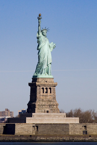
From the deck of the ferry you will have a perfect view of The Statue of Liberty and Ellis Island. You’ll see the skyscrapers and bridges of Lower Manhattan receding as you pull away and coming into focus again as you return.
A typical weekday schedule involves the use of five boats to transport approximately 60,000 passengers daily (109 daily trips). During the day, between rush hours, boats are regularly fueled and maintenance work is performed. Terminals are cleaned around the clock and routine terminal maintenance is performed on the day shift. On weekends, three boats are used (75 trips each Saturday and 68 trips each Sunday).
Over 35,000 trips are made annually.

– photo by Mitch Waxman
Mom is doing better, but still has a long way to go before she returns from disease to ease. Literal in my thinking, I often find myself lost in the technical aspect of words like “disease”- literally a lack of ease. I’m all ‘effed up.
It’s like the gulls say: ia, ia, ia

– photo by Mitch Waxman
In just a couple of weeks, a cool thing to do just might be hanging out with Kevin Walsh of Forgotten-NY and the Newtown Historical Society in Elmhurst.
Newtown Historical Society Walking Tour of Elmhurst – April 18th
The Newtown Historical Society, in conjunction with Forgotten-NY.com, will be hosting a walking tour of Elmhurst on Sunday, April 18th, 2010 at 2pm. We will meet at the token booth of the Grand Avenue-Newtown station on the R line at Broadway and Queens Blvd. Cost is $20 for non-members, $5 for members. Includes the guide services of Forgotten-NY’s Kevin Walsh and an informative historical pamphlet. Non-members will also receive a 1-year NHS membership.
Please RSVP to newtownhistory@gmail.com or call 718-366-3715 and leave your name, phone number and number of participants.

– photo by Mitch Waxman
Benefit to you, Lords and Ladies of Newtown, both spiritually and photographically- is found in the upcoming schedule of Working Harbor Summer Sunset Hidden Harbor Tours. I will be on the June 15th tour, for sure. Check out the Newtown Pentacle posting on last year’s June 15th excursion here:
from workingharbor.com
Working Harbor Committe of New York/New Jersey. Here are the dates & times for our 2010 series of Summer Sunset Hidden Harbor Tours® :
Tickets are on sale now. Click Here to purchase
And thats not all…..
We will announce some additional special tours soon, including Newtown Creek, Circumnavigation of Staten Island and, by popular request, Tugboat Rides!

– photo by Mitch Waxman
Also, and this is goofy, just like my little dog Zuzu- pictured above- but this is from the amazing boingboing– and yes- its NYC
Nichole East posted this video on Flickr documenting an exorcism performed by her neighbors last week. She also snapped the above photo of the friendly note she left them. (Thanks, Greg Long!)

– photo by Mitch Waxman
The ridicule of pretention and a desperate desire to describe wonders witnessed drive your humble narrator to offer these recent photos. Driven by hubris and frustrated aspirations, vast journeys across the major metropolitan city have been accomplished, and hundreds of images have been uploaded to my flickr page in the last week with dozens more awaiting review and file transfer. To wit…
Check out the Breezy Point ferry set here.
Leaving pre dawn from Pier 11 in Manhattan, the Breezy Point Ferry was potentially on its last run. Maritime enthusiasts, a quartet of us were assembled onboard. The burning thermonuclear eye of god itself was occluded by the silhouette of infinite Brooklyn as it opened upon the great metropolitan city. The fury of its gaze was apparent when the tiny ship entered the narrows, and the horizon was lit by omnipotent luminosity. That’s the Jane Reinauer tugboat, incidentally.

– photo by Mitch Waxman

– photo by Mitch Waxman
Other new photos to check out have recently hit flickr… Continuing experimentation with the “new camera” is producing intriguing views and exhibiting technical exercise and exploration of the wild possibilities and damning limitations hinted at in the first 3 months I’ve owned it.
Check out the Newtown Pentacle 14 set here.

– photo by Mitch Waxman
There’s a walk over the Williamsburg Bridge to be found in this NP 14 set…

– photo by Mitch Waxman
Wandering aimlessly around Queens never fails to produce interesting and enigmatic images… and for rail fans, there are shots from the A line in Rockaway in NP 14.

– photo by Mitch Waxman
A walk through Mt. Olivette cemetery in Maspeth and the revelations found atop the high ground of the terminal morraine… as well as the bottom of the hill along the Newtown Creek and adventures along the Kill Van Kull abutting Staten Island can be accessed in the Newtown Pentacle 13 set here.

– photo by Mitch Waxman
Lots of cemetery wandering can be observed in recent uploads, actually, it’s where I belong after all…

– photo by Mitch Waxman
Check ’em out, if you want a preview of the next few weeks of postings, there’s also an awful lot of photos at my flickr page.
I’m off on a boat trip in the storm today, heading for Albany along the Hudson River, an all day journey which will be completed by a twilight journey back by rail…
additionally, I’ve been helping out on the fledgling LIC Millstones blog, and have just uploaded a little history lesson from Bob Singleton of the Greater Astoria Historical Society that explains just what the heck a millstone is and why it matters that a significant and totemic piece of Queens from the colonial days is sitting in a construction zone in Queens Plaza. Here’s the vid:

– photo by Mitch Waxman
A legendarily squalid and desolate abode of pirates, gangsters, and irresolute opportunists- the docks of Manhattan- have been recast by modernity as “the financial district”- and simply referred to as “wall street”. The end of the line, the Staten Island Ferry docks at South Ferry and offers a free maritime connection between the far flung Staten Island and Manhattan across New York Harbor. The boat leaves every half hour, like clockwork (and the fleet is orange).
from wikipedia
The origin of the name South Ferry is probably one of the more misunderstood trivia, even to New Yorkers accustomed to using it in a geographical sense. One would suppose that it is so called because it is at the southern tip of Manhattan, and it hosts ferries. In actuality, it was the name of the South Ferry, one of several ferries between what were then the separate cities of New York and Brooklyn. The “Old Ferry”, which later was renamed the “Fulton Ferry”, crossed between Manhattan and Brooklyn from streets that in each city would eventually be renamed “Fulton Street” after the ferry company. The “New Ferry” crossed further east, between Catherine Street in Manhattan, and Main Street in Brooklyn.
As the City of Brooklyn grew, the area south of Atlantic Avenue (known as “South Brooklyn”) began to become built-up, but lacked easy access to the ferry terminals in the northern parts of the city of Brooklyn. Thus, a new ferry was established in 1836 to take passengers directly to Atlantic Avenue and the southern parts of the City of Brooklyn, and so was called the “South Ferry”. The ferry connected to the foot of Atlantic Avenue in Brooklyn and the Brooklyn and Jamaica Railroad (later part of the Long Island Rail Road) through the Cobble Hill Tunnel. In addition, South Ferry was the name of the Brooklyn landing and ferry house of the aforementioned ferry.

– photo by Mitch Waxman
Another great opportunity to take photos of the shining city is offered by this short trip, and one must pick a spot soon after boarding or the masses of camera wielding citizenry will cheat you out from an unoccluded vantage point. Staten Island is a rapidly growing part of New York City, a hilly district of quiet and well planted streets that frame envious homes on one shore, and highways lined with medium density apartment houses and condominiums on the other which are served by a never ending series of strip malls and the occasional “big box” store. The older sections of the community are of maritime heritage, largely, and clustered around the Kill Van Kull.
from wikipedia
In the 1700s ferry service between Staten Island and the city of New York (then occupying only the southern tip of Manhattan) was conducted by private individuals with “periaugers”, shallow-draft, two-masted sailboats used for local traffic in New York harbor. In the early 1800s, Vice President (and former New York governor) Daniel D. Tompkins secured a charter for the Richmond Turnpike Company, as part of his efforts to develop the village of Tompkinsville; though intended to build a highway across Staten Island, the company also received the right to run a ferry to New York. The Richmond Turnpike Company is the direct ancestor of the current municipal ferry.
In 1817 the Richmond Turnpike Company began to run the first motorized ferry between New York and Staten Island, the steam-powered Nautilus. It was commanded by Captain John De Forest, the brother-in-law of a young man named Cornelius Vanderbilt. In 1838 Vanderbilt, who had grown wealthy in the steamboat business in New York waters, bought control of the company. Except for a brief period in the 1850s, he would remain the dominant figure in the ferry until the Civil War, when he sold it to the Staten Island Railway, led by his brother Jacob Vanderbilt. (Three of the Staten Island ferries were requisitioned by the United States Army for service in the war, but none ever returned to New York harbor.)
– photo by Mitch Waxman
Just after passing Liberty Island, an abundance of industrial terminals and petroleum mills are apparent. A dizzying display of technology may be observed as the Ferry makes its way from Manhattan to Staten Island, and the lighting conditions demand a morning trip for photographic opportunities to be realized. You don’t have to be up fiendishly early, these shots for instance, were from a ferry ride that left Manhattan at 9:30 AM.
from nyc.gov
The Staten Island Ferry has been a municipal service since 1905, and currently carries over 21 million passengers annually on a 5.2-mile run between the St. George Terminal in Staten Island and the Whitehall Terminal in lower Manhattan. Service is provided 24 hours a day, 365 days a year. The Staten Island Ferry is the most reliable form of mass transit, with an on-time performance of over 96 percent.
A typical weekday schedule involves the use of five boats to transport approximately 65,000 passengers daily (110 daily trips). A four-boat (15 minute headway) rush hour schedule is maintained. During the day, between rush hours, boats are regularly fueled and maintenance work is performed. Terminals are cleaned around the clock and routine terminal maintenance is performed on the day shift. On weekends, three boats are used (64 trips each weekend day). Over 33,000 trips are made annually. Ferry terminal supervisors, assigned around the clock at both Whitehall and St. George, are responsible for ensuring that the ferry operates according to its published schedule (pdf) or (html).

– photo by Mitch Waxman
That’s the Vane Bros. Choptank, a very modern tug built by Thoma-Sea, a shipbuilder which operates out of the Lockport shipyard in Houma, LA. Vane Bros. and its plans for an ultra modern fleet was featured in a 2007 feature at professionalmariner.com.
from vanebrothers.com
The tug Choptank is the fifth in a line of Patapsco-class tugs. Like her sister tugs, she was designed by Frank Basile of Entech & Associates, and built by the Thoma-Sea Boat Builders in Houma, Louisiana. She joined the fleet in January 2007, and was subsequently named one of the “17 top new tugs of 2007” by American Tugboat Review, an annual publication of Professional Mariner.
The Choptank is 95’ long, 34’ abeam, and 15’ deep. Her gross tonnage is 99 tons. She is powered by two CAT 3516, 2100 horsepower engines with Kort nozzles, and maintains running speeds of better than 12 knots. Featuring a model bow and square stern, her fuel capacity is approximately 90,000 gallons. Potable water capacity is approximately 9,000 gallons. With accommodations for seven crew members, the Choptank is dedicated to 50-class tank barges on the coastwide trade.

– photo by Mitch Waxman
I love this boat, the Tug Ellen McAllister. A familiar sight in New York Harbor, it’s actually the same age as I am. I mentioned this ship in a posting about last June’s Working Harbor Committee “Sunset Cruise”.
The tug Ellen McAllister was originally built for the U.S. Navy, as the Piqua, at the Marinette Marine Shipyards in Wisconsin in July of 1967. The Piqua’s anchorage for many years was at Holy Loch, Scotland. It spent most of its naval career providing tug services for the 1st naval district and the Atlantic Fleet. It was sold under its current name in 2001 to McAllister Towing.
– photo by Mitch Waxman
Over there, that’s the Peter F. Gallatly, another Thoma-Sea built ship. A 1,200 HP, 327 GT tugboat, it went into service in December of 2008.
PETER F. GELLATLY
Official #: 1212432

– photo by Mitch Waxman
Just as the Ferry was maneuvering into its dock at St. George Terminal on Staten Island, Ellen McAllister was good enough to move into an egregious spot. This tugboat, of course, was the Division A winner of the 17th Annual Running of the Great North River Tugboat Race & Competition in 2009 and its Captain, Kirk Watts, won the contest for “Best Tattoo”. I was on a circleline observer boat at the event, and photos from the race can be found in this set at flickr.
from tuginformation.weebly.com
McAllister Towing is one of the oldest and largest marine towing and transportation companies in the United States. They operate a fleet of more than seventy tugboats and twelve barges along the East Coast from Portland, Maine to San Juan, Puerto Rico.
Although their corporate headquarters are located in New York City they operates in the ports of: Portland Maine, Staten Island New York, Philadelphia, Pennsylvania; Baltimore, Maryland; Hampton Roads, Virginia; Wilmington North Carolina, Georgetown, and Charleston, South Carolina as well as Jacksonville, and Port Everglades, Florida; including San Juan Puerto Rico. McAllister engages in ship docking, general harbor towing, coastal towing and bulk transportation.
Captain James McAllister started the first McAllister enterprise shortly after he arrived from Cushendall, County Antrim, Ireland . Together with his brothers and in-laws, McAllister formed the Greenpoint Lighterage Company. They augmented the lighterage business with towing, with the acquisition of their first steam tug, the R.W. Burke, in the 1880’s, while the Brooklyn Bridge was still being built. In the early twentieth century there was a period of innovation and expansion. Captain James was one of the first to convert a sail lighter into a bulk oil carrier, for the transport of oil around New York Harbor. The company also became known nationally for its salvage work, which extended from the West Indies, along the Atlantic Coast as far north as Maine.
In 1909, the company acquired the Starin Fleet of steamboat excursion vessels, forming the McAllister Steamboat Company, which was then among the largest excursion boat operators in New York, with regular runs to the Statue of Liberty, Bear Mountain, Coney Island, and Long Island. After the death of Captain James in 1916, his four sons assumed control of the company. The new partnership consisted of James, John E., Charles D. and William H., the second generation of McAllisters.

– photo by Mitch Waxman
The other night I dreamt that I walked over a river.
A former trolley car track on the Queensboro Bridge has been transformed by the City Fathers into a combined pedestrian and bicycle ramp, allowing non vehicular egress to and from the Shining City via Queens Plaza. This is not news of course, as thousands march and pedal across the steel and asphalt lane daily, and many of New York’s bridges allow similar crossings. A firm tenet of this, your Newtown Pentacle, is that you cannot see (really “see”) anything from a moving vehicle or train. You must walk, or scuttle, to truly observe the City.
from wikipedia
After years of decay and corrosion, an extensive renovation of the Queensboro Bridge was begun in 1987 and is still in progress, having cost over $300 million.
The upper level of the Queensboro Bridge has four lanes of automobile traffic and provides an excellent view of the bridge’s cantilever truss structure and the New York skyline. The lower level has six lanes, the inner four for automobile traffic and the outer two for either automobile traffic or pedestrians and bicycles. The North Outer Roadway was converted into a permanent pedestrian walk and bicycle path in 1999.
The Manhattan approach to the bridge is supported on a series of Guastavino tile vaults which now form the elegant ceiling of the Food Emporium and the restaurant Guastavino’s, located under the bridge. Originally, this open air promenade was known as Bridgemarket and was part of Hornbostel’s attempt to make the bridge more hospitable in the city.
In March 2009, the New York City Bridge Centennial Commission sponsored events marking the centennial of the bridge’s opening. The bridge was also designated as a National Historic Civil Engineering Landmark by the American Society of Civil Engineers during the year of its centennial anniversary.
The Queensboro Bridge is the first entry point into Manhattan in the course of the New York City Marathon and the last exit point out of Manhattan in the Five Boro Bike Tour.

– photo by Mitch Waxman
This little excursion, perambulating from Manhattan across the Great Machine’s central artery, was performed on a Tuesday after visiting medical personnel located at Union Square. The Manhattan section of the walk home to Astoria was vague, pedantic, and boring- the City just isn’t fun anymore. During my lifetime, the 45 blocks of Third Avenue transversed would have brought encounters with Junkies, Gangsters, Whores, and a series of intriguing book shops.
The scene today is wholesome, a pedantic stretch of mercantile resellers and upscale restaurants- interspersed by ATM locations. An interesting bit of trivia about Third Avenue, by the way, is that the reason that Bars and Saloons seem to be clustered around certain corners (terty terd and terd) is that their locations vestigially correspond to stops on the Third Avenue El. It’s also why Third seems so widely sited as compared to the other North South streets on the East Side of Manhattan.
from nycsubway.org
The east side branch of the New York Elevated Railroad fulfilled part of the promise of rapid transit yesterday by beginning to run trains from the South Ferry to the Grand Central Depot in Forty-second street. All matters had been thoroughly arranged before the first trip was made; the exact running time that the new engines could make was decided upon and a schedule had been carefully arranged. There were but few stations, however, at which passengers were picked up and dropped. Those were at South Ferry, Hanover square, Fulton street, Eighth street and Forty-second street. The first trip was made from South Ferry to Grand Central Depot at 5:30 A. M., and the distance traveled in twenty-five minutes.
A reporter of THE WORLD road on a train that left South Ferry about 1 P.M. This station is a common one for both branches, and many crowd in waiting started for the door when the agent called out “All passengers for the east side or Third avenue.” There were two handsome cars on the train of maroon color, touched with gold and light paints, and glistening with varnish. The engine also was new and was provided with a regular locomotive cab. The cars within were finished entirely in wood, the seats being of perforated pattern now so common, and running lengthwise of the car. The roofs were slightly decorated, and there was an appearance of neatness without the attempt at elegance of the Metropolitan road.

– photo by Mitch Waxman
Moving east on the Queensboro, one is always prompted to view the sum total of millions of hours of labor, which is called Manhattan (the Shining City). Cumulative, this enterprise called New York City is the end product of a supply chain that stretches across North America and all the way to the fabled Orient. This chain of supply requires distant farms, Canadian coal mines, Pennsylvanian steel mills, and Gulf Coast oil refineries to sustain the population of the Shining City.
At any given moment, on any given day, armadas of commercial goods are in motion toward New York City. On the eastern side of the island, the FDR drive snakes across the riverfront, carrying a ludicrous amount of vehicular traffic north and south across the island, connecting mighty Triborough to the ancient warrens of the Battery at the southern end of the island.
from nycroads.com
PLANNING AND CONSTRUCTION IN THE PRE-WAR ERA: In the 1920’s, public officials and business leaders in New York City proposed waterfront highways along both the Hudson River and East River. The Regional Plan of New York and Its Environs, which was released in 1929 by the Regional Plan Association (RPA), called for a depressed express highway – called the “Chrystie-Forsyth Parkway,” the precursor to the FDR Drive – along the East Side. The tenement districts along the East Side were to be replaced by high-rise buildings housing offices, stores and apartments. To maximize light and air, the widely spaced skyscrapers were to be separated by low-rise buildings and parks.
Robert Moses, arterial coordinator and parks commissioner for New York City, established his vision for the East River Drive: it was to feature six 12-foot-wide lanes, long viaducts for grade separation, and landscaping and parks between the parkway and the river. While the parkway did not have shoulders, it did have emergency pull-off ramps for disabled vehicles. Moses’ riverfront parkway was to connect lower Manhattan with the proposed Triborough Bridge.

– photo by Mitch Waxman
Near the equinox of the bridge, somewhere over- Blackwell’s… Welfare… oops- I meant Roosevelt Island- the occluding fencing of the pedestrian walkway allows a few openings large enough to stick a lens through, and intriguing details of the East River north of the Great Machine can be observed. Don’t forget to witness the locus of this Great Machine itself, with its cantilevered and geared steel persevering the weight of subways, trucks, auto traffic, and the pressure of the wind. There has always been something about the raw engineering of this structure that has appealed to me, one can almost see the lines of force dancing across the painted alloy.
the boweryboys have a fantastic and enjoyable podcast available on Roosevelt Island, and have posted a great collection of photos and (believe it or not) video from 1903 featuring Roosevelt Island that can accessed by clicking here.

– photo by Mitch Waxman
Gaze north, toward the extants of noble Astoria, and witness the diminutive Roosevelt Island Bridge with Hells Gate and mighty Triborough beyond. Recent events have revealed that this vista will be obliterated in the next ten years, as a shield wall of tower buildings have been sited and are in preliminary stages. The single large building in the shot is the Shore Towers building, a pygmy compared to what is coming.
note:
(Pygmy, like Esquimaux, is a somewhat racist term which is falling out of favor for describing ethnic groups of small stature. The African Pygmies, I am led to believe- prefer Aka, Baka, Mbuti, or Twa. Outsiders in Central Africa refer to them as Bambenga or Byaka. People of European cultural heritage, myself included, have a bad habit of giving things we don’t understand or fear pejorative names that we can understand- which makes us feel better about being afraid. Hence the colorful racial thesaurus of the northeastern United States in which there are at least 5 names for every ethnicity, and the reason why we “Americans” tend to refer to the UK as England, the Hellenic Republic as Greece, Zhōnghuá Rénmín Gònghéguó as China, and Bundesrepublik Deutschland as Germany. It’s “why they hate us”, ultimately.)
from nycroads.com
HISTORY OF ROOSEVELT (WELFARE) ISLAND: What is known today as Roosevelt Island was first purchased from the Algonquin Indians in 1637 by the Dutch, who promptly renamed the island “Varckens Eylandt,” or “Hog Island.” In the 1660’s, the British reclaimed the island from the Dutch after years of dispute. The island was granted to Captain John Manning, the sheriff of New York. In 1673, Manning was sentenced to death (later commuted to life imprisonment on the island) for relinquishing New York’s Fort James to the Dutch without a shot.
When Manning died in 1686, stepdaughter Mary Manningham renamed the island after her husband, Robert Blackwell. Blackwell Island remained in private hands until 1828, when the City of New York purchased it and transformed it into a setting for mental institutions, hospitals and prisons. Reflecting this setting as a repository for the down and out, the city renamed the property Welfare Island in 1921.
PROVIDING ACCESS TO THE ISLAND: Initially, access to Welfare Island had been through a series of ferries from Manhattan and Queens. In 1930, a four-cab elevator service began between the lower deck of the Queensboro (59th Street) Bridge and the island. The service, which had served 230,000 cars per year by the early 1950’s, provided the only public connection to Welfare Island.
The increasing traffic needs to and from Welfare Island, as well as growing congestion on the Queensboro Bridge, prompted the New York City Department of Public Works to propose a new vertical-lift crossing between Queens and Welfare Island. After initial resistance from the New York City Council, which doubted that the $6.5 million span would carry enough traffic to justify its cost, construction of the Roosevelt Island Bridge (then named the Welfare Island Bridge) began on March 17, 1952.

– photo by Mitch Waxman
Glancing south, Corbusier’s monolith casts its pale reflections, and the shining city stretches off to the Battery. This is a difficult viewpoint though, as the lanes of lower level bridge traffic are just yards away, and speeding vehicles occlude the perspective. Anyway, who cares about Manhattan anymore? Its nightlife has become a playground for those whom we in Brooklyn used to refer to as driving “Dadillacs” (daddy’s Caddy), and to reiterate- it’s just not fun anymore.
from nytimes.com
The six-story walk-up at 339 East 94th Street has seen much over the decades: generations of mostly white and Hispanic immigrants, nests of mice, drug deals, a police bust, at least one stabbing, a recent influx of young professionals, and a future presidential candidate: Barack Obama.
In his memoir, “Dreams From My Father” (Three Rivers Press, 1995), Mr. Obama described his Yorkville apartment, on East 94th Street between First and Second Avenues, as “part of the shifting border between East Harlem and the rest of Manhattan.” He described a scene that will sound familiar to undergraduates and others who scraped by in the seedy and dangerous New York of the 1980s:
It was an uninviting block, treeless and barren, lined with soot-colored walk-ups that cast heavy shadows for the rest of the day. The apartment was small, with slanting floors and irregular heat and a buzzer downstairs that didn’t work, so that visitors had to call ahead from a pay phone at the corner gas station, where a black Doberman the size of a wolf paced through the night in vigilant patrol, its jaws clamped around an empty beer bottle.

– photo by Mitch Waxman
The busy walkway and bicycle ramp on Queensboro has contributed to the general hostility developing in your humble narrator to the biking community. Now, I admit that the young couple in the shot above are breaking the rules and clearly walking in the bike lane, but they’re in love so let’s cut them a break. However, the aggressive entitlement displayed toward pedestrians by the biking community at large (especially on the Pulaski Bridge) compels me to call for the City to complete the process of normalizing bicycle commuting as standard vehicular transportation by requiring licensing, registration, and insurance. If you demand the right to be treated as legitimate vehicle on the streets of New York, you must comply with the law. No sneaking around red lights, charging crosswalks, or use of the sidewalk can be tolerated… imho.
from nyc.gov
Commuter bicycling in New York City has increased by 26% in the last year, building on last year’s unprecedented growth and representing a more than doubling in bike commuting in just the last seven years. The increase comes alongside the expansion of the City’s bike network, with the number of bike lanes nearly doubled the last three years.

– photo by Mitch Waxman
Incongruously handsome, the Rikers Island prison complex is visible from the bridge, the patina of it’s concrete reflecting the golden liberty lost to those within. A little known fact is that the population of Rikers Island is counted as part of our City Council’s 22nd district here in Astoria, but the inmates are not allowed to vote, rendering a sizeable portion of the actual population mute. I’m not advocating letting felons vote, but apportionment of city and state budgets are based on census data and not attendance at elections.
ERRATA!!! Reader Jayspec points out that this is the Manhattan Psychiatric Center on Ward’s Island, which is somewhat obvious in retrospect. Sorry gang, screwed up again- Mitch
from wikipedia
Rikers Island is New York City’s main jail complex, as well as the name of the 413.17-acre (1.672 km2) island on which it sits, in the East River between Queens and the mainland Bronx, adjacent to the runways of LaGuardia Airport. The island itself is part of the borough of the Bronx, though it is included as part of Queens Community Board 1 and has a Queens ZIP code. The jail complex, operated by the New York City Department of Correction, has a budget of $860 million a year, a staff of 10,000 officers and 1,500 civilians to control an inmate population of 14,000. The official permanent population of the island, as reported by the United States Census Bureau, was 12,780 as of the 2000 census.
The island is named after Abraham Rycken, a Dutch settler who moved to Long Island in 1638 and whose descendants owned Rikers Island until 1884, when it was sold to the city for $180,000. It has been used as a jail ever since.

– photo by Mitch Waxman
Big Allis is quite visible from the bridge, with its busy hive of conduits and valves feeding fuel to its cyclonic turbines. One of the little facts about Queens not being discussed in the current rush to overdevelop the quaint streets of the ancient hamlets of Newtown, which I fear will have dire consequence in the future, is the presence of critical facilities like this amongst large numbers of bourgeois newcomers. Examine the controversies in Long Island City at Hunters Point- the LIRR diesel idling noise (from liqcity.com) complaints, and realizations are beginning to surface in Tower Town that Long Island City is indeed “the Ancient Seat of Graft“.
from nytimes.com
The exhaust fans occupy a squat building that stands at an angle on 50th Avenue in Long Island City, Queens, in a narrow lot surrounded by brush and an iron fence, behind an elegant high-rise building half a block from the East River.
No one denies that they are a necessity: The fans clean the air in a tunnel for the No. 7 subway line when workers are making repairs, something that has happened a lot in the past few weeks and that will continue for several more weeks.
But the problem is that the fans come on without warning, mostly late at night, and stay on for hours, driving people to distraction because the noise makes sleeping virtually impossible.

– photo by Mitch Waxman
Passing the bridge tower driven into Queens, the real droning hum is to be found. Queens Plaza is being painfully reborn, and in as traumatic a manner to the surrounding communities as it can be. The survivors of the late 20th century, stolid holdouts who barred their windows and triple locked their doors- but who stuck out the bad years- are told simply to leave. Their century old homes are bought and paid for as “tear downs” by bonded foreign corporations who have been instructed by City officials to “do what thou wilt, for that shall be the whole of the law”.
Crowleyism seems to have become the governing principle of our republic, and ultimately the logic behind “American Exceptionalism“.
from wikipedia
Thelema roughly means “will” in Greek. The phrase True Will does not appear in The Book of the Law, the central sacred text of Thelema. Nevertheless, Aleister Crowley’s various commentaries on the Book routinely postulate that each individual has a unique and incommensurable True Will that determines his or her proper course in life. This invention of Crowley’s appears to be an attempt to explain how some actions may be wrong (or “false”) when “There is no law beyond Do what thou wilt.” Actions that conform to True Will are thus considered to be correct, while willed actions that deviate from True Will may nevertheless be wrong. In The Book of the Law Crowley wrote “Do What Thou Wilt”.
“DO WHAT THOU WILT” was misunderstood to mean do what you want, however one must consider that a human being is a single machine composed of several parts. So, when one says do what thou wilt , he/she must understand the origin of this will in order to promote or demote its importance. One is formed of a material, mental and spiritual component. These components are all controlled and directed by will that flows through the three and uniting them as one. Initiates of the sacred science are acquainted with the fact of a fourth dimension that is the base of this triad that forms a human being. True will is fourth dimension, that directs the human towards his destiny and forces him into the joy of accomplishing what he/she was meant to accomplish.

– photo by Mitch Waxman
The Great Machine, visible from the high deck of the Queensboro Bridge, beckons your humble narrator to scuttle home before it begins to get dark.
Predatory and fleet, shapes lurk in the sodium lit shadows of the Newtown Pentacle, hungry and weird things that care little for the normal or expected. Feckless, physical cowards such as myself are given to certain spells… vulnerable panics best experienced in one’s own rooms, in the company of my little dog.
That’s when I woke from my dream of walking across a river, in some Shining City with its cyclopean vistas of titan cut stones and sky flung monoliths…
I’m all ‘effed up.
from wikipedia
The categorical view of psychosis is most associated with Emil Kraepelin, who created criteria for the medical diagnosis and classification of different forms of psychotic illness. Particularly, he made the distinction between dementia praecox (now called schizophrenia), manic depressive insanity and non-psychotic states. Modern diagnostic systems used in psychiatry (such as the DSM) maintain this categorical view.
In contrast, psychiatrist Eugen Bleuler did not believe there was a clear separation between sanity and madness, and that psychosis was simply an extreme expression of thoughts and behaviours that could be present to varying degrees throughout the population.
This was picked up by psychologists such as Hans Eysenck and Gordon Claridge who sought to understand this variation in unusual thought and behaviour in terms of personality theory. This was conceptualised by Eysenck as a single personality trait named psychoticism.
Claridge named his concept schizotypy and by examining unusual experiences in the general population and the clustering of symptoms in diagnosed schizophrenia, Claridge’s work suggested that this personality trait was much more complex, and could break down into four factors.


