Posts Tagged ‘Brooklyn’
old privateers
It’s National Peach Ice Cream Day, in these United States.

– photo by Mitch Waxman
One believes that if you’ve got a problem to solve, the first step towards “victory state” over it involves wrapping your head around the problem and “getting smart.” I like to be fairly well educated about the nature of things before opening the hood and tinkering around with the engine, basically.
The subject of the MTA, or Metropolitan Transit Authority (a public benefit corporation), has been in the news quite a bit of late. The subways have been the particular focus, but the question a friend asked me the other night is what caused today’s post to come into existence.
What, exactly, is the MTA? Well, it’s complicated.
from wikipedia
Chartered by the New York State Legislature in 1965 as the Metropolitan Commuter Transportation Authority(MCTA), it was initially created by Governor Nelson Rockefeller to purchase and operate the bankrupt Long Island Rail Road. The MCTA dropped the word “Commuter” from its name and became the Metropolitan Transportation Authority (MTA) on March 1, 1968 when it took over operations of the New York City Transit Authority (NYCTA) (now MTA New York City Transit (NYCT)) and Triborough Bridge and Tunnel Authority(TBTA) (now MTA Bridges and Tunnels (B&T)). The construction of two bridges over the Long Island Sound was put under the jurisdiction of the MTA.
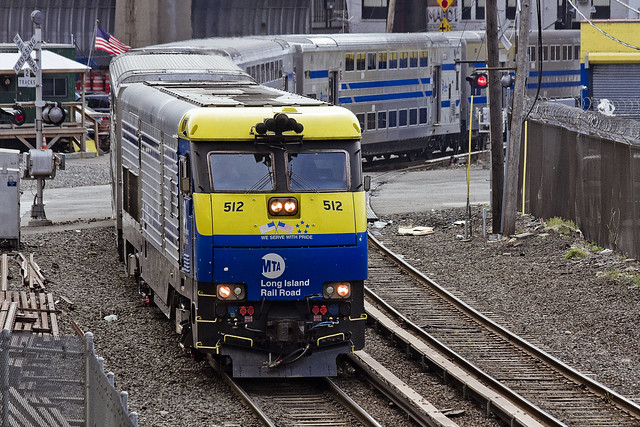
– photo by Mitch Waxman
To begin with, there’s just over 70,000 employees on the MTA’s payroll. MTA operates, ultimately, in the most densely populated sections of three states with the Shining City of Manhattan as the titular center and bullseye destination for its trains, automotive bridges and tunnels, and multiple fleets of buses.
Nearly all of the MTA train lines were originally built and owned by private businesses (with a significant public investment in the case of the subways) either during the late 19th or early 20th century, but bankruptcies and public foreclosures brought them into government hands. Private bus companies were acquired and folded into the Authority over the decades, along with bridges and tunnels that were formally owned and operated by seperate entities. Today, all of these operations are handled by the individual divisions of the MTA and overseen by a 17 member board of directors (who are all political appointees with virtually zero experience in transportation matters, incidentally).
from wikipedia
The Long Island Rail Road (reporting mark LI), legally known as the Long Island Rail Road Company and often abbreviated as the LIRR, is a commuter rail system in the southeastern part of the U.S. state of New York, stretching from Manhattan to the eastern tip of Suffolk County on Long Island. With an average weekday ridership of 337,800 passengers in 2014, it is the busiest commuter railroad in North America. It is also one of the world’s few commuter systems that runs 24 hours a day, 7 days a week, year-round. It is publicly owned by the Metropolitan Transportation Authority, which refers to it as MTA Long Island Rail Road.

– photo by Mitch Waxman
Capital Construction is where all the money disappears into, basically. Pictured above is the Second Avenue Subway under construction, and however much I wish that I could show you a shot from the East Side Access project – I haven’t managed to find a way to get my camera down there, yet. The MTA is ostensibly meant to be self funding, through bonds it issues and through fare revenue, but it seldom works out that way and both State and City end up sending a significant amount of tax revenue their way to handle deficits.
Everybody asks why it is that these mega projects orchestrated by Capital Construction have the political support that they do while the wheels are falling off the buses and subways. Short answer is that a shot of a politician watching some mechanic turn a wrench while repairing a track switch is a lot less compelling an image, electoral politics wise, than one showing the same politician cutting a ribbon at the opening ceremony of a fancy new subway stop in the richest section of Manhattan on the Uppper East Side.
Capital Construction, like all of MTA’s divisions, is a vertical silo with its own hierarchy and political patronage. They do what they do, and compete for funding with the other divisions.
from wikipedia
MTA Capital Construction is a subsidiary agency of the Metropolitan Transportation Authority (MTA), formed in July 2003 to manage the MTA’s major capital projects in the New York metropolitan area. It mainly focuses on improving transportation infrastructure and facilities in New York City, the Hudson Valley, and Long Island areas. Funding primarily comes from local, state, and national bond sales and budgets. As of April 2017, the current MTA Capital Construction president is Janno Lieber.

– photo by Mitch Waxman
Long Island Railroad, for instance, is a vertically integrated “thing” all of its own. If someone from the Metro North side of MTA calls in sick, they don’t send LIRR employees upstate to fill in the slack. It doesn’t share “synergies” with Metro North (repair facilities, union contracts etc.) or with the New York City Transit Authority (subways). This situation is owed partially to the formerly seperate corporate entities that created the original lines.
Metro North is the grandchild of the old New York Central Railroad passenger service, and the LIRR is the child of Central’s arch rival and adversarial enemy – the Pennsylvania Railroad Company.
I’m no expert on this subject, so, I reached out to a buddy who is one of my “rail rabbis” and he anonymously offered this statement and assessment of the situation involving Metro North and LIRR, which – despite logic and what you might think, don’t use the same trains nor operate in common fashion or custom.
“Metro-North Railroad is made up of three distinct operations. Two of these operate out of Grand Central Terminal, the third operates out of Hoboken Terminal.
Hudson and Harlem lines are the remnants of the New York Central Railroad (Vanderbilt), out of Grand Central Terminal.
The New Haven line is the former New York, New Haven and Hartford Railroad (New Haven for short).
The New Haven was unique in that they operated commuter trains out of Grand Central Terminal and their long distance trains out of Penn Station. The line over Hell Gate was financed by the New York Connecting Railroad, which was a paper railroad business agreement between the New Haven and the Pennsylvania Railroads.
The third operation is frequently overlooked. it is the former Erie Railroad (Jay Gould, THE robber baron), later Erie Lacawanna Railroad operation to Port Jervis New York. MTA pays for the New York portion, while New Jersey Transit pays for the New Jersey operation. This operates out of Hoboken Terminal.
The New York Central and Pennsylvania Railroad merged in 1968 into the Penn Central (Good book to read is “The Wreck of the Penn Central” by Joseph R. Daughen and Peter Binzen).
It was an unhappy merger, with battles between the two different management ideologies. It ended up with the US Government creation of Conrail in 1976 to salvage what remained of several north east railroad operations (Including Penn Central).
Conrail operated many commuter railroads, which received state subsidies for commuter operations. (Amtrak was formed in 1971 for intercity/long distance passenger trains, not the many commuter operations) Conrail wanted out of commuter operations at its founding and in 1983, it was NY States turn and Metro North was created.
The LIRR and Metro North are two distinct systems, with the only real compatible technology being the train couplings and the gauge of the trains.
Metro North utilizes an under-running third rail and the LIRR utilizes an over running third rail. Diesel locomotives and diesel hauled electric passenger cars also weigh different, with Metro North being able to haul heavier equipment, Long Island bridges are load limited. The Park Avenue Tunnels on Metro North and the East River Tunnels on the Long Island also limit the interchangeability of some equipment. Signal systems are also different.
The Electric Multiple Unit (MU) trains of Metro North and LIRR look similar and are ordered from the same vendor/companies, but they are configured to operate on their respective systems. They are not freely interchangeable. The Arch Street shop of the LIRR is a warranty shop for the recent purchase of the M-7 MU’s. Metro north ships them there for work, but not before all the third rail shoes are removed, and they have to travel over the Hell Gate from New Rochelle, NY. (The Ventilation system vents on the Metro North Roofs won’t fit in the LIRR East River Tunnels).
The LIRR bilevel cars will not fit in the Park Avenue tunnels.
Metro North diesel locomotives are too heavy for the bridges on the eastern end of Long Island.”
from wikipedia
The Metro-North Commuter Railroad (reporting mark MNCW), trading as MTA Metro-North Railroad or simply Metro-North, is a suburban commuter rail service run by the Metropolitan Transportation Authority (MTA), a public authority of the state of New York. With an average weekday ridership of 298,900 in 2014, it is the second-busiest commuter railroad in North America in terms of annual ridership, behind its sister railroad, the Long Island Rail Road. Metro-North runs service between New York City and its northern suburbs in New York and Connecticut, including Port Jervis, Spring Valley, Poughkeepsie, White Plains, and Wassaic in New York and New Canaan, Danbury, Waterbury, and New Haven in Connecticut. Metro-North also provides local rail service within New York City at a reduced fare. There are 124 stations on Metro-North Railroad’s five active lines (plus the Meadowlands Rail Line), which operate on more than 775 miles (1,247 km) of track, with the passenger railroad system totaling 385 miles (620 km) of route.

– photo by Mitch Waxman
Another vertical silo at MTA is the Bridges and Tunnels group. This is Robert Moses’ old Triborough Bridge and Tunnel Authority empire, rebranded and “nationalized” by Nelson Rockefeller back in the late 1960’s. TBTA has always been, and always will be, its own fiefdom.
For those of you not familiar with the terms “vertical silo” or “synergies,” that’s a fairly archaic series of terms used in the investment banking industry to describe business units within a corporate structure. When a corporate merger occurs, the investment bankers will often try to “flatten” these silos and merge them with other units to avoid redundancy, which saves them money and ostensibly streamlines an operation. This is not how Government people think, btw. If the MTA was a company and got taken over by another corporation, the VERY first thing the new owners would do is try to flatten these silos and eliminate the wasteful or redundant departments.
MTA, for instance, has multiple divisions of armed police and guardsmen. There’s TBTA cops, MTA cops, MTA Operations armed guards, a whole seperate department of MTA Security… and they’re all operating under different rules, jurisprudence, and circumstance.
It’s all very complicated.
from wikipedia
The Triborough Bridge and Tunnel Authority, doing business as MTA Bridges and Tunnels, is an affiliate agency of the Metropolitan Transportation Authority that operates seven intrastate toll bridges and two tunnels in New York City. In terms of traffic volume, it is the largest bridge and tunnel toll agency in the United States, serving more than a million people each day and generating more than $1.5 billion in toll revenue annually as of 2012.
The seven bridges are:
- Triborough Bridge (officially Robert F. Kennedy Bridge), the agency’s original namesake and flagship crossing, connecting Manhattan, the Bronx, and Queens, via Randalls and Wards Islands
- Bronx–Whitestone Bridge, connecting the Bronx and Queens
- Verrazano-Narrows Bridge, connecting Brooklyn and Staten Island
- Throgs Neck Bridge, connecting the Bronx and Queens
- Henry Hudson Bridge, connecting Manhattan and the BronxMarine Parkway–Gil Hodges Memorial Bridge, connecting Brooklyn and the Rockaways (Queens)
- Cross Bay Veterans Memorial Bridge, connecting Broad Channel to the Rockaways (Queens)
The two tunnels are:
- Brooklyn–Battery Tunnel (officially Hugh L. Carey Tunnel), connecting Brooklyn and Manhattan
- Queens–Midtown Tunnel, connecting Queens and Manhattan

– photo by Mitch Waxman
The focus of public ennui these days is generally related to the subway system, although this summer the LIRR situation has gathered a lot of storm clouds to the Long Island Railroad. What New Yorker hasn’t stood there on some subway platform and exhorted “EFF YOU, MTA” at least once?
My rail rabbi quoted above offers this, on the subject of the “switch problems” and the MTA’s promises that modernizing them will fix everything wrong with the subways:
“One thing we mentioned about “outdated signal systems” with regard to the subway is that the 100 year old signal, while worn out, allow better utilization of the tracks. As I understand it, typical headways on the NYC subway system are four to seven minutes at rush hour. As a comparison, newer fully automated systems, like BART in San Francisco, WAMATA in Washington DC and MARTA in Atlanta can’t beat seven minutes, with ten minutes being the normal.”
A humble narrator has been getting increasingly involved with transit issues in recent years, and I’ve joined the steering committee of Access Queens, a community organization led by Sunnyside’s Melissa Orlando, which grew out of the “7 train blues” Facebook group. I won’t bore you with the usual song you’ve read everywhere else about switches, overcrowding, deferred maintenance, and aging tracks – instead I’d ask for you to click through to the Access Queens site and see what our group has been working on.
It may be the “Summer of Hell” for the LIRR, but it’s always transit hell in Queens.
from wikipedia
The New York City Transit Authority (also known as NYCTA, The TA or simply Transit, and branded as MTA New York City Transit) is a public authority in the U.S. state of New York that operates public transportation in New York City. Part of the Metropolitan Transportation Authority, the busiest and largest transit system in North America, the NYCTA has a daily ridership of 7 million trips (over 2 billion annually).
The NYCTA operates the following systems:
- New York City Subway, a rapid transit system in Manhattan, The Bronx, Brooklyn, and Queens.
- Staten Island Railway, a rapid transit line in Staten Island (operated by the Staten Island Rapid Transit Operating Authority, a NYCTA subsidiary)
- New York City Bus, an extensive bus network serving all five boroughs, managed by MTA Regional Bus Operations.

– photo by Mitch Waxman
The MTA Bus company is part of NYCTA, or New York City Transit Authority, but that’s not all of it. There’s tons of bus lines in Nassau and Suffolk Counties, Yonkers, and even Westchester which MTA operates. Buses aren’t the sexiest way to get around, of course, but when it’s raining a bus is always superior to walking. Unfortunately, the vertical silo of the bus company seldom coordinates with the NYCTA subway company during outages and planned work, nor coordinates their schedule with them.
from wikipedia
MTA Regional Bus Operations (RBO) is the surface transit division of the Metropolitan Transportation Authority (MTA), created in 2008 to consolidate all bus operations in New York City operated by the MTA.
Upcoming Tours and events
The Poison Cauldron of the Newtown Creek Walking Tour, with Atlas Obscura – July 22nd, 11 a.m. – 2 p.m..
Explore the hellish waste transfer and petroleum districts of North Brooklyn on this daring walk towards the doomed Kosciuszko Bridge, with NCA Historian Mitch Waxman – details here.
“follow” me on Twitter- @newtownpentacle
discovered peculiarities
It’s National Pecan Pie Day, in these United States.

– photo by Mitch Waxman
One says it all the time – “you never know what you’re going to see along the lugubrious Newtown Creek, so bring your camera.” Last week, I was attending an event at the Newtown Creek Wastewater Treatment Plant Nature Walk in Greenpoint when something surprising occurred.
As a note, not sure if my friend’s project is “public” yet, but when it is I’ll share links with you.

– photo by Mitch Waxman
It wasn’t surprising to see a tugboat at Newtown Creek. It’s still a quite busy maritime industrial waterway, although it’s a shadow of itself compared to a century ago during the First World War when more cargo (by tonnage) than the entire Mississippi River moved along its contaminant stained bulkheads.
What was surprising is what’s intruding on the shot above, in the lower left hand corner. That’s a fishing pole.

– photo by Mitch Waxman
Some fellow rode up on his bike and began assembling his angling equipment, while I was at the Nature Walk. He dropped a hook and lure into the waters of Whale Creek, where the sludge boats dock, and began wiggling his line around. I had a brief chat with him – nice guy – and he assured me that he was “catch and release” fishing and wouldn’t dream of eating anything caught in NYC’s waters.
Then his line went taught and he began to engage the fishing rod’s reel.

– photo by Mitch Waxman
That’s a striped bass which he pulled up out of the Whale Creek tributary of Newtown Creek. Whale Creek adjoins and is entirely contained by the largest and the newest of NYC’s 14 sewer plants, and as mentioned above, is where the so called Honey (or sludge) Boats dock, and where they load up the treated and concentrated sewer sludge. There’s also a combined sewer outfall at Whale Creek, which is odd as it’s on the grounds of a sewer plant, but that’s the DEP for you.

– photo by Mitch Waxman
Sport fishing, or “catch and release” as its called, is something I have absolutely no problem with. Saying that, one of the folks also attending the event at the Nature Walk was offended and offered “why harm and annoy such a magnificent animal?” I’d say the same thing if somebody was dropping hooks out of trees for raccoons, but maybe that’s my terrestrial mammal privilege at work. The good news is that there are foot and a half long fish swimming around in freaking Newtown Creek.
Guess that the offended person should have been offered a trigger warning that the real world had been entered, and that fishermen and hunters are amongst the most avid environmental and conservation minded folks you can find. This particular kvetch is well known to me, incidentally, so I can tell you in advance that attempting to offer a particular observation or logic conflicting with their own would have returned naught but a stony glance.

– photo by Mitch Waxman
I can report that the fish, a striped bass incidentally, would likely have agreed with this very sensitive person who frequently annoys me. The blood was coming from the hook, which the angler pried out before releasing the critter back into the waters of Newtown Creek. Fish heal pretty quickly, I’m told.

– photo by Mitch Waxman
A humble narrator has said it before, and will say it again: “you never know what you’re going to see along the lugubrious Newtown Creek, so bring your camera.”
Upcoming Tours and events
13 Steps Around Dutch Kills Walking Tour, with Newtown Creek Alliance – July 15th, 10 a.m. – 1 p.m..
The “then and now” of Newtown Creek’s Dutch Kills tributary in LIC, once known as the “workshop of the United States.” with NCA Historian Mitch Waxman – details here.
The Poison Cauldron of the Newtown Creek Walking Tour, with Atlas Obscura – July 22nd, 11 a.m. – 2 p.m..
Explore the hellish waste transfer and petroleum districts of North Brooklyn on this daring walk towards the doomed Kosciuszko Bridge, with NCA Historian Mitch Waxman – details here.
“follow” me on Twitter- @newtownpentacle
loosely knit
It’s National Piña Colada Day, in these United States.

– photo by Mitch Waxman
Given that the final weeks of the old Kosciuszcko Bridge spanning the fabled Newtown Creek are at last upon us, one has been determined to record a few portrait shots to commemorate its long tenancy over the waterway. To wit, last week, one determined that it was time to carry the tripod all the way to eastern Greenpoint and stand there in the dark while shooting the end of an era in this particular corridor of the “House of Moses.” The tripod was needed to allow for long exposure, hyperfocal aperture depth, and deep saturation. Where I was will be instantly recognizable to some Newtown Creek enthusiasts, but to most – not so much. It’s off the beaten path, off the pavement in fact, and my specific vantage was shielded from street lights, perfectly dark, and stunk to high heaven from a passing slick of sewage.
Ahh… my beloved Newtown Creek.
I’m pretty happy with what I got in the shot above, which is a 30 second exposure captured at about 9:10 p.m. As always, if you click the photo it will open up a new window to Flickr, where you can zoom in or whatever.

– photo by Mitch Waxman
While I was there – and as you’d imagine – one shot multiple variations of the first shot in today’s post using different exposure triangles, but it was randomly decided at the end of my little seission to pivot the tripod head about and get some shots of the surrounding creek as well. This is looking northward at the Queens side, and that black slab forming the background against the sky is the tree line of First Calvary Cemetery.
Documenting this project has been a long standing project of mine – this 2012 post tells you everything you could want to know about Robert Moses, Fiorella LaGuardia, and the origins of the 1939 model Kosciuszko Bridge. Just before construction started, I swept through both the Brooklyn and Queens sides of Newtown Creek in the area I call “DUKBO” – Down Under the Kosciuszko Bridge Onramp. Here’s a 2014 post, and another, showing what things used to look like on the Brooklyn side, and one dating back to 2010, and from 2012 discussing the Queens side – this. Construction started, and this 2014 post offers a look at things. There’s shots from the water of Newtown Creek, in this June 2015 post, and in this September 2015 post, which shows the bridge support towers rising. Additionally, this post from March of 2016 detailed the action on the Queens side. Most recently, here’s one from May of 2016, and one from June of the same year. Here’s one from August of 2016, the December 2016 one, one from March of 2017 which discusses the demolition of the 1939 bridge.
Most recently – a post showing what I saw during a pre opening walk through in early April of 2017, and the fanfare surrounding the opening of half of the new bridge in April of 2017, and a walk through of the Brooklyn side job site in June of 2017.

– photo by Mitch Waxman
Looking west along the Newtown Creek, towards the Shining City of Manhattan. The burning thermonuclear eye of God itself doesn’t dip behind the skyline until about 8:30 this time of year, and the shot was captured less than five minutes after the first shot in today’s post. That’s about when Indecided to break down the gear and head back to the rolling hills of Astoria, after having spent about an hour at my location.
As far as the burning question everybody’s been asking me – no, I don’t have any intel on when the old bridge is coming down or not. Newtown Creek Alliance has recently published this post, which discusses the issue in detail and tells you what to expect from the operation.
Upcoming Tours and events
13 Steps Around Dutch Kills Walking Tour, with Newtown Creek Alliance – July 15th, 10 a.m. – 1 p.m..
The “then and now” of Newtown Creek’s Dutch Kills tributary in LIC, once known as the “workshop of the United States.” with NCA Historian Mitch Waxman – details here.
The Poison Cauldron of the Newtown Creek Walking Tour, with Atlas Obscura – July 22nd, 11 a.m. – 2 p.m..
Explore the hellish waste transfer and petroleum districts of North Brooklyn on this daring walk towards the doomed Kosciuszko Bridge, with NCA Historian Mitch Waxman – details here.
“follow” me on Twitter- @newtownpentacle
sterner things
It’s National Bomb Pop Day, in these United States.

– photo by Mitch Waxman
As described in yesterday’s post, a hurried flight from “Point A” in Astoria to “Point B” in Brooklyn’s Greenpoint section was enacted last Saturday, in order to arrive on time for a walk through and discussion of the NYC DOT’s Kosciuszcko Bridge project’s commitment to create new parkland in the post facto footprint of their construction zone. Invitees were community members, folks from Open Space Alliance, NYC Parks Department, and a few local busybodies such as myself.
That’s Robert Adams, of the New York State Department of Transportation, chief engineer and showrunner for the K Bridge replacement project.

– photo by Mitch Waxman
I’ve stated many times that the community communications side of this project has been extraordinary. I’ve also reported to a number of people that Mr. Adams, in particular, has been remarkably transparent and amiable to receiving input from those who surround the perimeter of his project. Gold standard, in my experience, as far as handling the impact of a large scale public works projects in the crowded urban industrial setting of Newtown Creek in North Brooklyn and Western Queens. Kudos.

– photo by Mitch Waxman
As has become familiar – when visiting the K Bridge job site – our little group donned “Personal Protective Equipment,” which included safety glasses, gloves, orange vests, and hard hats. That paved sidewalk, on the left of the shot above adjoining the retaining wall for the Brooklyn Queens Expressway’s Meeker Avenue onramp, is “used to be Cherry Street.” The street we were walking down, in a northerly direction heading towards Scott Avenue, is nouveau Cherry Street.
– photo by Mitch Waxman
That’s the new overpass at Varick Avenue, looking westwards towards the East River.
Documenting this project has been a long standing project of mine – this 2012 post tells you everything you could want to know about Robert Moses, Fiorella LaGuardia, and the origins of the 1939 model Kosciuszko Bridge. Just before construction started, I swept through both the Brooklyn and Queens sides of Newtown Creek in the area I call “DUKBO” – Down Under the Kosciuszko Bridge Onramp. Here’s a 2014 post, and another, showing what things used to look like on the Brooklyn side, and one dating back to 2010, and from 2012 discussing the Queens side – this. Construction started, and this 2014 post offers a look at things. There’s shots from the water of Newtown Creek, in this June 2015 post, and in this September 2015 post, which shows the bridge support towers rising. Additionally, this post from March of 2016 detailed the action on the Queens side. Most recently, here’s one from May of 2016, and one from June of the same year. Here’s one from August of 2016, the December 2016 one, one from March of 2017 which discusses the demolition of the 1939 bridge.
Most recently – a post showing what I saw during a pre opening walk through in early April of 2017, and the fanfare surrounding the opening of half of the new bridge in April of 2017.

– photo by Mitch Waxman
Just shy of Gardner Avenue, currently a closed off section of the construction site, Mr. Adams began to discuss the perimeter of the new park. It will quite literally be in DUKBO, Down Under the Kosciuszcko Bridge Onramp. The site will occupy a mostly paved area largely shadowed by the two new bridges. Our group discussed the possibility of shade tolerant plants, and or harvesting “gray water” from the highways to feed into planting beds.
The problem with that, as stated by somebody from Parks Dept. was this – shade tolerant plants are seldom salt resistant and that even without harvesting runoff from the BQE’s drains, there’s going to be a considerable amount of road salting during the winter months both above and below the parcel.

– photo by Mitch Waxman
The demolition of the old bridge is going to be occurring shortly, which will play out in two stages. First is the removal of the central truss section, then the “energetic demolition” of the approaches. If the schedule holds true, the second half of the new K Bridge will open in 2020 standing in the footprint of the old one.
That’s when the parks business will begin in earnest. There’s a section on the Maspeth side, on 43rd street, in Queens. Another section is this parcel in Brooklyn, and the old Sgt. Dougherty park on Meeker avenue at Chery Street is going to be redesigned and rebuilt.

– photo by Mitch Waxman
One of the interjections a humble narrator offered, as one who knows this zone intimately enough to refer to it affectionately as the “Poison Cauldron of the Newtown Creek,” involved the intended pathways which people from the surrounding neighborhoods would use to get here. The surrounding areas to the east and south are insanely dangerous, traffic wise, with gargantuan trucks whizzing about and all sorts of blue collar people doing blue collar things. Warehouses, waste transfer stations, truck and bus mechanics… not to mention all of the autos at Meeker Avenue angrily straining to get into the approach lanes for the BQE.
In short, way finding and traffic control.

– photo by Mitch Waxman
About those waste transfer stations… one of the things that makes this particular “cauldron” so “poison” is the tonnage of putrescent – or black bag – garbage transported here daily. This section of DUKBO is covered in quite toxic dust. Harvesting a booger from your nasal cavity after a walk through this section will reveal many things to you about the quality of air and suspended particulates. There’s also the smell.
DUKBO stinks of decay, rot, and hot garbage. On humid days, you will notice swirls of diesel exhaust along with shiny specks of dust hanging in the ether, as illuminated by an odd shaft of light. In short – dust and odor control are essential.
The choice of this area is an extremely challenging one for a park, but given the paucity of parkland in North Brooklyn – beggars can’t be choosers and you have to work with what you’ve been given.

– photo by Mitch Waxman
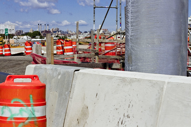
As far as the construction progress side of things, as mentioned, DOT and their contractor’s efforts are now being focused on the removal of the 1939 era Kosciuszcko Bridge. Up top, traffic has long been rerouted onto the easterly half of the new span, and torch bearing demolitionists have been cutting up small sections of the old bridge. The former walkway and the side railing has been cut up and will be sent off for recycling.

– photo by Mitch Waxman
Above Newtown Creek, but below the BQE, crews are assembling the “strand jacks” which will lower the central truss down to a waiting barge. The steel of the central truss is also meant to be recycled, and will be making a final journey to New Jersey escorted by tugs sometime during the coming month.

– photo by Mitch Waxman
This is the view from Scott Avenue, and the new park will continue down to the bulkheads and will overlook the water, I’m told. There has been some discussion of waterfront access here, as in a place where you’d be able to put a boat in the water, but one hasn’t been a part of that conversation.

– photo by Mitch Waxman
Walking back, as we crossed Gardiner Avenue, I handed off my “PPE” to Mr. Adams and bid the group adieux rather than go all the way back to Meeker and Varick Avenues where we had met up.
I headed down instead to the site of the first Meeker Avenue, or Penny Bridge. Once upon a time there was a swing bridge on Newtown Creek which connected Brooklyn’s Meeker Avenue with Queens’ Review Avenue (and the Penny Bridge LIRR stop). Penny Bridge was demolished in 1939 when the new Meeker Avenue Bridge opened (renamed as Kosciuszcko in 1940) but the masonry on both sides of Newtown Creek are still present.
It was a neat idea, I thought, visiting all three Meeker Avenue Bridges in the same day.
History nerd here, what can I tell ‘ya?

– photo by Mitch Waxman
While I was at Penny Bridge, my zoom lens was dialed to its extant focal length and I zeroed in on the Queens side’s strand jacks being erected. Hey, I may be a history nerd, but I know for a fact that several of you out there are engineering nerds.
Upcoming Tours and events
Newtown Creek, Greenpoint to Hunters Point, walking tour with NYCH2O – June 29th, 7-9 p.m..
Experience and learn the history of the western side of Newtown Creek, as well as the East River Parks Hunters Point with NCA Historian Mitch Waxman – details here.
“follow” me on Twitter- @newtownpentacle
resonant profanity
It’s National Ceviche Day, in these United States.

– photo by Mitch Waxman
“I’m late, I’m late, For a very important date. No time to say “Hello, Goodbye”. I’m late, I’m late, I’m late” is what was going through a humble narrator’s brain box last Saturday morning. Often is Lewis Carroll psychically conjured on my way to Newtown Creek, a place which is the very definition of “through the looking glass” for one such as myself.
Accordingly, a vehicular coach was summoned via the LYFT application found on my pocket telecommunications device, which automotively conveyed one to the poison cauldron of the Newtown Creek in Greenpoint. The driver, following the directions offered by a computer program on his own pocket telecommunications terminal, used the Brooklyn Queens Expressway for the trip. For once, rolling the dice on the BQE paid off and it was a quick journey between “Point A” in Astoria and “Point B” in Brooklyn.

– photo by Mitch Waxman
We crossed the lugubrious Newtown Creek on the sparkling new 2017 model Kosciuszcko Bridge, with the 1939 version just to the west. As one such as myself cannot turn down an opportunity to record and catalog any and all visual experiences encountered in the City of Greater New York, the camera was being waved around in the back seat as the driver performed his particular function in the front.

– photo by Mitch Waxman
The NYS DOT is currently working on the dismantling of the 1939 version, which is at an early stage. Newtown Creek Alliance has recently prepared and propagated a post describing what we know about the various stages, scheduling, and status of the demolition project for the so called “K Bridge,” and it can be accessed here.

– photo by Mitch Waxman
You may recall that I was up here for opening day of the new bridge back in April, but that was on foot. Dedicated pedestrian that I am, it’s an odd thing to actually be riding in an “auto-mobile,” but since I had experienced a fairly late night the evening before – one had risen later than planned and there was no way that I was going to get to Brooklyn from Astoria on time via perambulatory means.
I’m actually obsessed with being “on time” and am particularly keen on “being early” for events and meetings. It’s kind of a “thing” with me. My parents always insisted that you arrive early to appointments, as that’s at least one thing that the people you’re going to see can’t hold against you. Mom always said “you can’t do anything about being ugly, stupid, ungrateful, and unlikeable but at least you can be early.” I’m all ‘effed up.

– photo by Mitch Waxman
This wasn’t a tour, per se, as in one I was conducting of the area which I’ve long referred to as “DUKBO” or Down Under the Kosciuszcko Bridge Onramp.” Instead, the NYS DOT is in the early stages of planning two parks – one in Queens and one here in Brooklyn. They called together members of the K Bridge Stakeholders Advisory Committee (I’m on that one) and the Brooklyn Parks group “Open Space Alliance,” or OSA, to discuss the space and begin the process of planning.
I showed up wearing my Newtown Creek Alliance hat, but since we were going to enter the job site, it was soon replaced by a hard hat that said “Skanska.”
– photo by Mitch Waxman
My LYFT driver was instructed by both myself and the computer program on his pocket computer terminal to exit the BQE at the Meeker avenue stop, which was terribly exciting for one such as myself as I’m a “creek geek.”
Kept on thinking about that white rabbit, me. It was nearly the time for the meetup with DOT and OSA, and I’d still have to walk a block or two to the location.

– photo by Mitch Waxman
That’s the east side of Meeker Avenue pictured above, with its newly constructed on-ramps and approach roadways feeding traffic from Brooklyn into Queens. It’s been so chaotic in this area for the last few years, what with the construction and all, that it was quite a relief to see a bit of calm inserted back into DUKBO.

– photo by Mitch Waxman
Saying that, there was still quite a hullabaloo going on in DUKBO.
The demolition of the 1939 bridge will be the supreme focus of all the concerned parties for the next several months, but for right now the teams of contractors and union hard hats are making busy with repaving local roads and improving the subterranean infrastructure (sewers, drains etc.) that serve the new bridge. I know the folks who live in the house that that backhoe is working in front of, who are… shall we just say… anxious for the project to conclude.
Tomorrow, I’ll show you what I saw whilst wearing the hard hat in DUKBO.
Upcoming Tours and events
Newtown Creek, Greenpoint to Hunters Point, walking tour with NYCH2O – June 29th, 7-9 p.m..
Experience and learn the history of the western side of Newtown Creek, as well as the East River Parks Hunters Point with NCA Historian Mitch Waxman – details here.
“follow” me on Twitter- @newtownpentacle


