Posts Tagged ‘Dutch Kills’
rather gruesomely
Like every other bit of wind blown trash in NYC, this is where I belong.

– photo by Mitch Waxman
Despite being a shambling and sclerotic mess, nevertheless does a humble narrator scuttle on about and around the Newtown Creek in the middle of the night. Recent endeavor found one in Blissville to attend a meeting of the newly created Blissville Civic Association, which the community has formed in response to the Mayor dropping multiple homeless shelters into their midst, and afterwards one set out to a nearby tributary of that legendary cataract of urban malfeasance known as the Newtown Creek – specifically Long Island City’s Dutch Kills.
That’s the Borden Avenue Bridge in the shot above, but don’t ask me where the shot was captured from as I’d have to confess to a misdemeanor. Suffice to say that every nook and cranny is known to me. It’s all I’ve got, ultimately.

– photo by Mitch Waxman
Either the world happens to you, or you happen to the world.
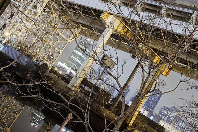
That’s the Long Island Expressway above, riding on a truss bridge that carries it some one hundred and six feet over the waters of Dutch Kills. The height was determined by the demands of the War Department of the Federal Government, who had laid down the law to State of New York that the LIE would need to allow egress for maritime vessels on Dutch Kills, and specifically vessels of the Naval surface warfare type.

– photo by Mitch Waxman
One has read some of the planning documents for this section of the LIE, which is officially the Queens Midtown Expressway, and sections of said plans discussed the need to defend Newtown Creek and the larger harbor of New York against a potential maritime invasion by German naval forces in the run up to WW2. One of the guiding principles was the defense of the industrial zones, and the East River corridor specifically. The Navy’s theory was that the Kriegsmarine would enter New York Harbor via the Narrows between Brooklyn and Staten Island (there was no bridge there in the 1930’s) and that would be the most strategic and effective spot to interdict the German Navy. Accordingly, in the case of such an invasion they would have stationed Destroyer class vessels in Newtown Creek and the Gowanus (as well as other places) to act as protective bulwarks for the industrial operations.
The Navy plan also intended for the Destroyers to fire artillery southwards over Brooklyn to shell the Narrows on vast parabolas. The people in Bay Ridge would have loved that one, I tell you, had it been commonly known. Fuhgeddaboutit.
Upcoming Tours and Events
April 29 – Bushwick-Ridgewood borderline Walking Tour – with Newtown Historical Society.
Join Kevin Walsh and Mitch Waxman as they take us along the border of Brooklyn and Queens, Bushwick and Ridgewood, with stops at English Kills, an historic colonial Dutch home, and all kinds of fun and quirky locations. End with an optional dinner on Myrtle Avenue before heading back to the Myrtle-Wyckoff subway station. Tix are only $5 so reserve your space today!
Tickets and more details here.
“follow” me on Twitter- @newtownpentacle
long miles
Borden Avenue Bridge and environs, in today’s post.

– photo by Mitch Waxman
There have been three Borden Avenue Bridges, the first being a wooden draw bridge that opened when Borden Avenue was created in 1868. It was replaced by an iron swing bridge which was demolished in 1906, and the modern day retractile bridge was opened on the 25th of March in 1908. It cost $157, 606 to build in 1908. That would be $4,365,073 in modern money, adjusted for inflation.
A bargain, no?

– photo by Mitch Waxman
Borden Avenue Bridge is one of only two retractile bridges in NYC, the other one being the infinestimal Carroll Street Bridge over the Gowanus Canal. This specie of movable bridge is actually quite common in other cities, notably Chicago.
Chicago ain’t got a view like the one above though, I’d wager.

– photo by Mitch Waxman
To the south of Borden Avenue, one might notice the two railroad bridges spanning Dutch Kills – Cabin M and DB Cabin. The latter carries traffic for the Lower Montauk Branch of the LIRR from the Wheelspur to Blissville Yards, all of which which are mainly used for freight these days. Cabin M connects to the Montauk Cutoff, a now severed connection to the Sunnyside Yards and the LIRR Main Line tracks.
Just beyond the two rail bridges is the main body of Newtown Creek.
– photo by Mitch Waxman
Dutch Kills itself, in this area around the Borden Avenue Bridge, is stagnant and choked with wind blown garbage. A tepid current in the water creates a vertical rather than horizontal flow pattern, which factors into the accretion of sediments on the bottom. These sediment beds, which are found across the entire Newtown Creek watershed and represent a centuries long cross section of industrial and municipal pollution, are the reason that the Creek and its tributaries are a superfund site.
At low tide, mounds of this material become exposed to the air.

– photo by Mitch Waxman
For many years, there was a shanty dwelling here, occupied by some unknown entity. Hurricane Sandy ended that tenancy.

– photo by Mitch Waxman
My chosen path next carried me eastwards on Borden Avenue, away from my beloved Creek and deeper into the post industrial landscape of Long Island City. The concrete devastations were calling to me.
“follow” me on Twitter- @newtownpentacle
quietly slipped
After dark peregrinations about the Newtown Creek.

– photo by Mitch Waxman
That’s the Hunters Point Avenue Bridge pictured above, a centuried single bascule drawbridge. Your humble narrator was actually a Parade Marshal for the centennial celebration, back in 2010. The first Hunters Point Avenue Bridge, which sat on roughly the same spot, was erected in 1874 and was made of wood. It opened and closed thanks to a mule walking on a turntable. The modern bridge is the property of the NYC Department of Transportation, and the agency has been working on the span since last summer, repairing and upgrading electronics which were damaged by Hurricane Sandy back in 2012.
The water it overflies is the Dutch Kills Tributary of the Newtown Creek, which branches off of the main waterway about 3/4 of a mile from the East River. Dutch Kills itself, in its modern incarnation, is about 3/4 of a mile long. It once ran all the way through the modern day Sunnyside Yards and fed into a marsh/swamp which would have been centered at 29th street and Jackson Avenue in LIC. That’s just before the elevated Subway breaks off to the North along 31st street and Jackson widens to become Northern Blvd.

– photo by Mitch Waxman
Over the years, one has spent a considerable amount of time along the canalized shorelines of Dutch Kills. There’s a mega structure crossing it, the truss carrying the Long Island Expressway some one hundred and six feet over the water.
November 15th of 1940 is when this section of the LIE opened, and the “high speed road” carries vehicle traffic first to the Queens Midtown Tunnel and then into Manhattan.

– photo by Mitch Waxman
Looking to the north/west, the turning basin of Dutch Kills and the remains of the Degnon Terminal.
A turning basin is an engineered section of a waterway shaped to allow an articulated tugboat and barge egress to rotate and turn around. The Degnon Terminal offered ship to rail connections back in the early 20th century, and cargo could be loaded or unloaded onto a terminal railway or onto freight cars of the Long Island Railroad for delivery to extant points.

– photo by Mitch Waxman
On the east side of Dutch Kills, the FedEx people have a large shipping depot that squats squamously. A LEED certified facility, the FedEx property nevertheless logarithmically magnifies the number of trucks worming through traffic to LIC every day from Kennedy Airport.
Semi trucks carry FedEx cargo here from the airport, delivery vans carry it out to their end customers.

– photo by Mitch Waxman
When these shots were captured, the air was terribly still. Without any sort of atmospheric perturbence, the tepid currents of Dutch Kills’ fluids barely register as a ripple on the surface.
Last time I checked, the LIE carried about 90,000 vehicle trips a day in this section (called the Queens Midtown Expressway), which translates out to around 32 million vehicles annually. The drains on the LIE are not connected to the City’s sewer system and instead drain directly into Dutch Kills. At least there’s some current, I guess.

– photo by Mitch Waxman
My path next carried the camera south to Borden Avenue.
The street dates back to 1868, when it was built as a plank road through the swamps surrounding Dutch Kills. It got its name in a traditional fashion for the 19th century, named for where it was going. It used to be the pathway to the Borden Dairy farm up the hill in Maspeth, and was constructed to allow easy egress for fresh milk to travel to market in Manhattan and beyond.
“follow” me on Twitter- @newtownpentacle
inimical oddity
Darkness continues.

– photo by Mitch Waxman
It rained all day on Sunday, whereupon a non precipitatating mist set itself up in the atmosphere during the evening hours. Given my recent fascination with wandering about the darkened Newtown Creek watershed in such conditions, a humble narrator strapped on the camera kit and debarked HQ for Long Island City. My target for this photo excursion was a section of the waterway found in Long Island City, specifically the Dutch Kills tributary.
Pictured above, looking across Skillman Avenue and the “A section” of the Sunnyside Yards towards Jackson Avenue and the Sapphire Megalith.

– photo by Mitch Waxman
A decade ago, one used to refer to this area as “Lonely Island City” since you’d seldom see anything other than a stray or lost human back here. The “zone” around the Degnon Terminal was largely deserted until recent years, when the Real Estate Industrial complex began to construct large dwellings on former industrial land along Jackson Avenue and elsewhere in LIC. All of a sudden, the humans began to appear back here.
Where can a guy go to be alone with his thoughts in Western Queens these days? Always somewhat nocturnal, a humble narrator’s solution to the presence of the human horde has simply been to shift my schedule a bit. This causes loved ones no end of worry, me wandering about in the darkness all by my lonesome.

– photo by Mitch Waxman
You’re never unobserved or truly alone in Long Island City, it should be mentioned.
In the cupola of the Sapphire Megalith, there is an impossible thing which cannot exist that is always watching you with an unblinking three lobed burning eye, after all. It hungers for profit and employs an army of acolytes to do its bidding.

– photo by Mitch Waxman
Additionally certain precautions are taken, including the usage of a reflective construction worker’s vest which is roughly worn over the filthy black raincoat. Last week, in the comments, somebody asked if I carry a firearm when I’m out at night shooting to protect myself from malign passerby who might want to rough me up in pursuance of stealing my camera or emptying my pockets. I don’t.
Were a stranger to strike me, filth and disease would crawl up their arm causing them to collapse into a pile of mouldering meat and rotting bone. That’s what I’m packing – plague and death are the horsemen I ride with.

– photo by Mitch Waxman
Atmospherically, everything was pretty much what I hoped it would be when leaving Astoria for points south and west. The mists and clouds were largely at high altitude, and only ribbons of fog were present at ground level.
My plan for the evening was to spend only a few hours wandering about, but I actually ended up being out for nearly six hours, whereupon I returned to HQ and developed the shots I had captured. One didn’t get to bed until about five in the morning, hence the late post you’re reading right now.

– photo by Mitch Waxman
One did not experience any missing time, as a note, I was working the whole time. If I was abducted by a UFO, I’m certain that shots of it would have been on my camera card when I got home. Pictured above is 29th street along the Dutch Kills turning basin, looking back at the gargantuan complex of residential luxury buildings erected within the last decade in the Court Square area of LIC.
The thing in the Megalith has won.
“follow” me on Twitter- @newtownpentacle
safe arrival
A visit to Sims Metal Management over in LIC.

– photo by Mitch Waxman
All summer long, one has a tendency to lead walking tours of the neighborhoods surrounding the fabulous Newtown Creek. There are boat tours too, but these walking and boat excursions are generally public facing tours that visit public places. My job is to provide historic context for wherever we happen to be, and describe the various issues each particular area is facing. There’s one spot along the Newtown Creek, however, which I only bring college or graduate student groups to. That’s Sims Metal, in Long Island City, and I brought a college group there last Saturday.
There’s a million reasons for this restriction, and number one is not wearing out my welcome.

– photo by Mitch Waxman
Number two revolves around the very busy schedule of this waterfront business. Luckily, Sims and its management are anxious to spread the word about their recycling operations. Their Sunset Park facility was actually purpose built with visitors in mind and they maintain an education center at that site. The Newtown Creek operation is different, and is a very busy industrial site.
When I can get a group in here, the entire operation pretty much shuts down in the name of safety. The working guys love it when they see me walking a group up the road, I think, as they get to take a coffee break.

– photo by Mitch Waxman
Number three is a safety issue. Several of the times I’ve been here, just on my own – it’s been strictly hard hats and steel toe boots, gloves, glasses, the whole “working guy” uniform. With a largish group of students, this isn’t realistic, so the site manager tells his crew to take a break and then carefully guides us around the site’s edges and discusses the services which the company offers.
Those services include the receipt and initial sorting of the “MGP” (metal glass plastic) and cardboard/paper materials collected by the Department of Sanitation’s curbside recycling program, which is what’s going on in the first photo of this post. All of this municipal contract material will be barged out of the Creek and sent for finer levels of sorting and processing at the Sunset Park facility.
I got to visit the operation in Sunset Park last summer, and did two posts about it – “Noxious Mysteries” and “Unusually Worried“. The latter one details the actual process of sorting recyclable garbage, if you’re into that sort of thing.

– photo by Mitch Waxman
The other side of Sims’ operations here at Newtown Creek revolves around commercial customers. If it’s made of metal and you’re disposing of it, Sims is one of the larger players in the recycling business. Materials like the mountain of rebar pictured above get shipped here by truck from upland sources, then are loaded onto barges and sent off to be processed at another Sims facility.
My understanding is that material like that rebar in the shot above will be sent off to Jersey City and fed into a shredder.

– photo by Mitch Waxman
The “big show” at Sims on Newtown Creek always revolves around the stacks of automobiles and trucks which they process. All the fluids, batteries, and various onboard tanks have been removed from these vehicles before they get trucked in. The discarded or junked vehicles are trucked into Sims and then stacked for eventual placement on a barge. That barge will be escorted by a tugboat over to another Sims facility in New Jersey where they’ll be fed into a shredder.
I’m told that said shredder will reduce a car to metallic toothpicks in a few seconds, but no matter how many times I ask, the Sims people say it’s just too much of a safety risk to let me close enough to photograph that part of the process.

– photo by Mitch Waxman
The academic group I was shepherding around last weekend were urban planning students from MIT, and were in town to study the industrial zone in Long Island City. I’ve also had Robin Nagle’s NYU class back here, as well as a group from a Dutch university who make an annual visit to Newtown Creek. We only ask Sims to open their gates to us for academic groups, as a note.
The mission of the Newtown Creek Alliance is to “reveal, restore, revitalize” Newtown Creek. Bringing student groups to Sims Metal is part of the “reveal” side of the job. You should see what my colleagues are up to on the “restore and revitalize” planks, which you’ll have ample opportunity to do this summer.
“follow” me on Twitter- @newtownpentacle


