Posts Tagged ‘E Line’
And on the fourth day…
Wednesday
– photo by Mitch Waxman
There were two more old friends whom I wanted to reconnect with – in person – on my recent NYC visit. The first of these individuals and I had breakfast in Forest Hills at the diner pictured above. Recommended.
The outlandish plan for shedding soiled garments along the way had played out well, and after leaving behind yesterday’s t-short, skivvies, and socks in Hank the Elevator Guy’s kitchen garbage pail in Middle Village, I was now down to just the one camera bag instead of multiple bags.
My host (Hank) was bid ‘adieu,’ and one summoned a cab to carry me to that meet up with my buddy Mike at the diner. Afterwards, he walked me to Queens Boulevard, and the nearest subway stop.
The next meetup was over in Queens Plaza.
– photo by Mitch Waxman
The E arrived in minutes, and I was again on my way. This was going to end up being another long, long day. My flight back to Pittsburgh was scheduled for 7 p.m., but would end up getting pushed back due to weather – first to 9, then 10:30, and I finally boarded the plane at 11:41 p.m. Yeah… ‘bah!’
Y’know what – I kind of do miss the subway a bit. Easy Pickens for rail shots, and that air conditioner blast when you get onboard…
– photo by Mitch Waxman
Queens Plaza, and I was about a half hour or so early to meet up with my friend. Couldn’t help but talk a short walk while waiting, and it was startling. Another friend of mine coined the term ‘real estate frenzy’ a while ago to describe what’s been happening here for the last ten to fifteen years, but I have to say that ‘the frenzy’ seems to have turned into ‘a real estate riot’ while I’ve been gone. Wow.
It does seem like the paint isn’t dry on one of these new tower buildings before a massive population of people is moved into it.
– photo by Mitch Waxman
One of several weird things now extant: an enormous population of pedestrians. Used to be that people were just scurrying around to get to and from the train stations in Queens Plaza. Now you’ve got young couples with babies, old people with walkers, all sorts milling about on Jackson Avenue. Shoppers. It’s weird.
I cannot imagine somewhere I’d like to live less than Queens Plaza, but you do you, boo. The noise, man…
– photo by Mitch Waxman
The screeching of steel on steel is omnipresent. Queensboro Bridge allows the transit of tens of thousands of vehicle trips a day, and the Sunnyside Yards (State Superfund Site, and also one of the contributing ‘PRP’s’ to the nearby Newtown Creek Federal Superfund Site) are in your back yard here. I like (from a visual perspective) and have photographed this area for years, but from a purely existential point of view – this would be a challenging place to live due to all the constant tumult and noise.
Not my problem anymore, as I keep reminding myself.
– photo by Mitch Waxman
I met up with my buddy Paul, one of my oldest friends. We went to Junior High School together, and have stayed in touch with each other during good times and bad. We met up, and then headed for mighty Queensboro.
One of the many things that have changed here in the World’s Borough is that the Queensboro Bridge’s southern outer roadway (which used to be a trolley line’s right of way) has been closed to vehicle and bicycle traffic and is now a designated pedestrian path.
The last time I got to walk this one was when I was a Parade Marshal for the bridge’s centennial back in 2009, and I had Borough President Helen Marshall with me.
Back tomorrow.
“follow” me on Twitter- @newtownpentacle
Buy a book!
“In the Shadows at Newtown Creek,” an 88 page softcover 8.5×11 magazine format photo book by Mitch Waxman, is now on sale at blurb.com for $30.
lasting merely
Wednesday
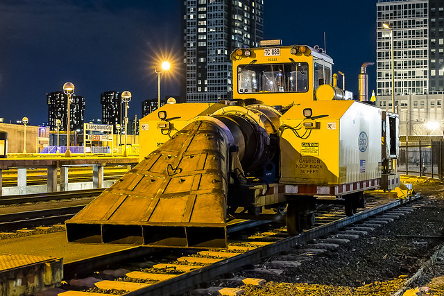
– photo by Mitch Waxman
That machine pictured above blows. Literally. It’s a jet engine on rail wheels which the LIRR uses for clearing snow and evacuating litter and leaf debris from the tracks.
Hunters Point Yard, Long Island City. It blows, but doesn’t suck, this gizmo. Want to know what else blows? Our perception of danger, and of the return of “Fear City.”
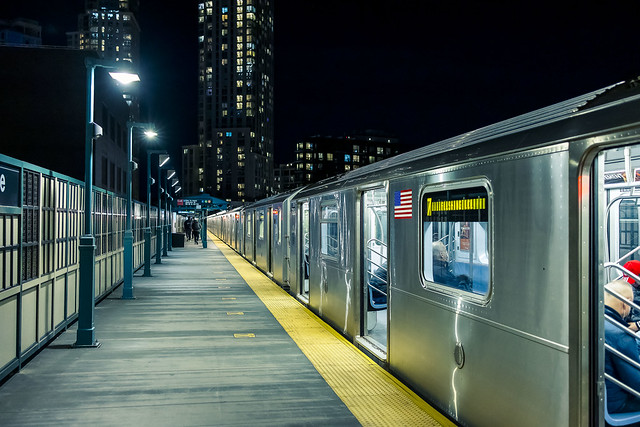
– photo by Mitch Waxman
A quick walk found me riding on a 7 train, which took me to the Court Square Station in LIC. According to what I see on the news these days, I should have experienced something like Act 3 of the post apocalyptic “Road Warrior” movie, but unmolested was a humble narrator.
Seriously, other than the curious instruction from MTA, observed several times on printed and electronic poster boards within “The System” which adjures against barbecuing on subway platforms or within moving subway cars, I haven’t seen much of “out of the ordinary” down below.
It ain’t the 80’s, or even the 90’s down there… not yet, at least.
– photo by Mitch Waxman
People have been walking around with their heads up their arse for decades on the topics of “crime and safety,” which is due to “Copaganda” in my opinion.
Your chances of getting jumped… personally, I walk around everywhere with my radar on at full power at all times and have been eschewing the use of headphones while commuting… are certainly less than they were in the 1980’s, but have never been absent. Many just chose to believe that they were safe or something, and the looney tales propagated out to the news media by “certain” municipal unions which reinforce public perceptions of their centrality to all things good and great has created an impression that a) the cops could “fix it” if only they had more money and more cops and less reforms and more blah blah, and b) that the people committing these outlandish criminal acts in these stories could be cured if only there was more funding for mental health and affordable housing and blah blah blah.
Ask a hammer how to fix a broken window, it’ll say “hit it with a hammer.”
Here’s a different way to experience things – with your own eyes. Some people are good, others are bad, and a small percentage of them are straight up scumbags. We should create a penal colony on Mars and populate it with these scumbags, I’ve always thought.
Australia has worked out fairly ok, why not have a Marstrailia?
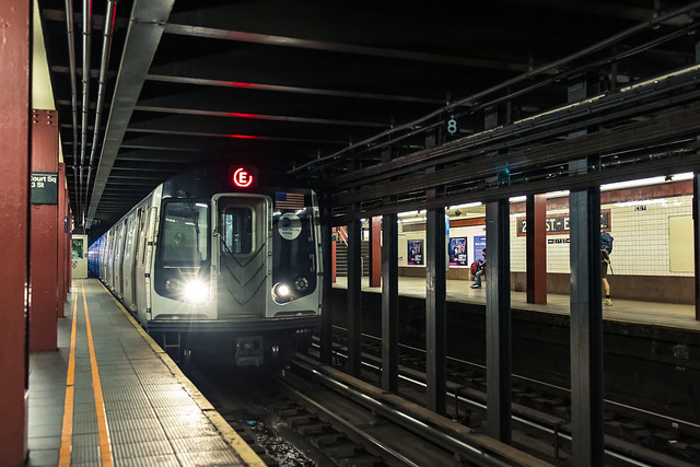
– photo by Mitch Waxman
With my own eyes – I have not seen people BBQing in the subway, but I’ve seen fare evasion and all sorts of “normal” NYC bullshit occurring more often post Covid than before.
About a month ago, an obviously ill scumbag was yelling ugly racial rhetoric at random passerby, right here at the Court Square Station. More than once have I observed the same guy doing the same thing. Cops? Nope. Would they clip him, or just force him to move on?
The one that really cooks the noodle for me is that although the ugly sentiments that this guy offered would be considered a hate crime, and despite the fact that he’s clearly “not healthy” mentally, do we really want the NYPD to get into the business of policing what people can and can’t say in the Subway – or anywhere else?
I’ve mentioned in this space that I’ve had weird encounters on the street during the pandemic, which could have gone “ass over tits” quickly if I didn’t possess the experiences of having grown up and lived in NYC all my life. I know how to talk and act in these situations, and when it’s time to run away or scream at the top of my lungs for help.

– photo by Mitch Waxman
Queens Plaza was the next point of subway line transfer, where I would connect with an R line subway that would carry me to the subway stop which is nearest to HQ in Astoria. Queens Plaza is where some poor woman got attacked with a hammer, with said hammer wielded by some scumbag from Manhattan. The subway stop in Astoria I was aiming myself at is found at an intersection where, in 2020, a young mother found herself caught in a crossfire of bullets being fired indiscriminately by two random bunches of local scumbags. She died.
If the cops happened to be in the Queens Plaza station, and also happened to be nearby that staircase where the scumbag with the hammer attacked that woman, you can bet your bottom dollar that NYPD’s legendary lack of subtlety would have been on full display. The gunfight in Astoria, which was one of about 8 or 9 such exchanges which have occurred within a couple of blocks of that Astoria subway stop… how do you stop that? Drug trade gonna drug trade, gangstas gonna gang, bangers gonna bang.

– photo by Mitch Waxman
As mentioned, my radar is being maintained at full power these days.
Nobody gets to within eight steps of me without an assessment, and receiving a series of non-verbal cues that they’ve been noticed and are dancing too close. Saying all that, be careful, scumbags are and always have been everywhere.
Real life isn’t what you hope it is, instead it’s entirely unpredictable and two out of every ten people are scumbags. Further, four of the remaining eight can flip either good or bad depending on the crowd they’re in. Good news? There’s generally two out of the ten who will be ok people no matter what happens.
Thankfully, the R train arrived. Some scumbag took a dump in the car I was riding in, but hey – it’s only three stops to where I gotta get off so…
“follow” me on Twitter- @newtownpentacle
Buy a book!
“In the Shadows at Newtown Creek,” an 88 page softcover 8.5×11 magazine format photo book by Mitch Waxman, is now on sale at blurb.com for $30.
unsigned letter
It’s National Drive-Thru Day, in these United States.
– photo by Mitch Waxman
Ain’t nothing like a heat wave in NYC, huh? Regardless of tropical clime, nor distances involved, a humble narrator nevertheless surged forward into the wilds of Long Island’s western tip recently to gather photographs and experience the truculent realities of our time.
One left Point A in Astoria via the usual means, onboard the so called “R” or Broadway Local Line .
from wikipedia
The R Broadway Local is a rapid transit service in the B Division of the New York City Subway. Its route emblem, or “bullet”, is colored yellow since it uses the BMT Broadway Line in Manhattan.
The R operates local between 71st Avenue in Forest Hills, Queens and 95th Street in Bay Ridge, Brooklyn at all times except nights when it short turns at Whitehall Street–South Ferry in Lower Manhattan from Brooklyn.
– photo by Mitch Waxman
Ultimately, one sought to gain access to the Crosstown or “G” line, which the MTA folks annoyingly force one to enact two transfers to get to from Point A, despite the platform’s location less than a mile and a half from my starting point (and the fact that the G used to run through the same station which I caught the R at). Accordingly, at the sweltering bunker of dripping masonry which the MTA designates as “Queens Plaza,” one debarked the R and vouchsafed a single station ride upon the “E” – or Eighth Avenue Local Line – to the Court Square station where yet another transfer was enacted to access the G.
Urine, it smelled deeply of urine, at the Court Square station.
from wikipedia
The E Eighth Avenue Local is a rapid transit service in the B Division of the New York City Subway. Its route emblem, or “bullet”, is blue since it uses the IND Eighth Avenue Line in Manhattan.
The E operates at all times between Jamaica Center–Parsons/Archer in Jamaica, Queens, and Chambers Street–World Trade Center in Lower Manhattan, running express on the IND Queens Boulevard Line in Queens (except nights when it serves all stops) and local in Manhattan. E trains also serve two local stops in eastern Queens (75th Avenue and Briarwood) on evenings and weekends.

– photo by Mitch Waxman
My penultimate destination, on this particularly warm evening, was Sunset Park – which adjoins the legend choked streets of the Red Hook section of Brooklyn. One does realize, of course, that the R could have taken me all the way to this area which is called “Sunset Park,” but that would have multiplied my travel time due to a circuitous route which transverses all of Manhattan and a good chunk of Brooklyn.
The G discharged a humble narrator, vomiting me forth onto the platforms at the sky flung Smith/9th street station, high over the loathsome and shadow haunted Gowanus Canal. The Gowanus Canal smells of urine (and other things) as well, of course.
from wikipedia
The G Crosstown Local is an 11.4-mile-long (18.3 km) rapid transit service in the B Division of the New York City Subway. Its route emblem, or “bullet”, is colored light green since it uses the IND Crosstown Line.
The G operates at all times between Court Square in Long Island City, Queens and Church Avenue in Kensington, Brooklyn via the IND Crosstown and Culver lines. In Queens, it only serves two stations – Court Square and 21st Street, both in Long Island City – but previously served all stations to and from 71st Avenue in Forest Hills on the IND Queens Boulevard Line.
– photo by Mitch Waxman
My plan was to pass through the “House of Moses” and under the Gowanus Expressway section of the Brooklyn Queens Expressway, exploiting the shaded path which is offered by this elevated roadway, and head south towards Sunset Park. It should be mentioned, incidentally, that this is perhaps the least pedestrian friendly area in all of Brooklyn. Brobigdagnian trucks whiz about at high speed, angry motorists lurch their vehicles to and fro in frustrated bursts, and the pavement is both shadowed by the expressway above and in a delitorious state of repair.
Also, there’s vampires hiding in the rafters of the Gowanus Expressway.
from nycroads.com
The Gowanus Expressway, which serves as the southern extension of the Brooklyn-Queens Expressway, also connects the Brooklyn-Battery Tunnel approach, the Prospect Expressway (NY 27), the Belt Parkway and the Verrazano-Narrows Bridge. Although guide signs and maps refer to this segment of I-278 as the Brooklyn-Queens Expressway, it is known locally as the Gowanus Expressway.
Beginning in 1939, Robert Moses oversaw construction of the Gowanus Parkway, an elevated highway placed on top of the pillars of the old 3rd Avenue BMT Elevated Line through the Sunset Park and Gowanus sections of Brooklyn. It would eventually become part of a limited-access parkway loop encircling four of the five boroughs. Since the Gowanus Parkway was to be constructed atop a pre-existing elevated facility, Moses had little trouble getting his project approved by the New York City Council.
However, the Gowanus Parkway would require more land for a wide roadway and entrance-exit ramps. This required the demolition of many homes and businesses along Third Avenue, a tightly knit block of Northern and Western European immigrants.

– photo by Mitch Waxman
There are charming sights to be found along the Gowanus Canal, I should mention, lest you think I’m prejudiced against the “Superfund Sister to the South” of my beloved Newtown Creek. Abundant waste transfer and oil distribution facilities, endemic pollution, lakes of unknown chemical constitution lurking just below the streets, untreated sewage oozing out of unmarked pipes? These are all the things I love.
One has never understood the appeal of “going to the country” and vacationing amongst the rural yokels. Camping? Are you insane? I’ve got a dry bed and a door that locks here in NYC, where I get to witness a looming infrastructure crisis and unfolding environmental apocalypse whenever I want to.
from wikipedia
The Gowanus Canal is a canal in the New York City borough of Brooklyn, on the westernmost portion of Long Island. Connected to Gowanus Bay in Upper New York Bay, the canal borders the neighborhoods of Red Hook, Carroll Gardens, and Gowanus, all within South Brooklyn, to the west; Park Slope to the east; Boerum Hill and Cobble Hill to the north; and Sunset Park to the south. It is 1.8 miles (2.9 km) long. There are seven bridges over the canal, carrying Union Street, Carroll Street (a landmark), Third Street, Ninth Street, Hamilton Avenue, the Gowanus Expressway, and the IND Culver Line of the New York City Subway.

– photo by Mitch Waxman
That’s part of the Gowanus Canal, pictured above, as shot from the Hamilton Avenue Bridge and looking back north towards the Smith/9th street station which the G line disgorged me into. Used as I am to the wild expanses and geographic extent of Newtown Creek, my thoughts always turn to compactness when I’m at the Gowanus. Thing is, just like Newtown Creek and its tributaries – two of which the Gowanus would tuck neatly into – the canal interacts with ground water and flows beneath the streets via its connections with the sewer system. Just like Newtown Creek, many of the sewers connected to the Gowanus are in fact former tributary waterways which were converted and buried at the end of the 19th and start of the 20th centuries. Who can guess, all there is, that might be buried down there?
Additionally, both Gowanus Canal and Newtown Creek sport maritime industrial bulkheads along most of their length which are little more than artifacts of the Second Industrial Age, in our modern day NYC.
from nyc.gov
The Hamilton Avenue Bridge is a bascule bridge with two parallel leafs, one carrying the northbound roadway and the other carrying the southbound roadway. Most of the length of Hamilton Avenue runs below the elevated portion of the Gowanus Expressway, including the bridge. The bridge connects Smith Street and Second Avenue over the Gowanus Canal and is the first canal crossing north of the Gowanus Bay.

– photo by Mitch Waxman
Regardless of musings about the wasted space, lack of public access, and utter degradation of the air, water, and soil – one had somewhere to be, and a little bit of walking was required to get there. A humble narrator put his head down, leaned into a southerly declination, and scuttled off into the clouds of auto exhaust mixing with the humid air.
The Gowanus Expressway dwelling Vampires be damned, I needed to get to Sunset Park.
from wikipedia
A vampire is a being from folklore that subsists by feeding on the life essence (generally in the form of blood) of the living. In European folklore, vampires were undead beings that often visited loved ones and caused mischief or deaths in the neighbourhoods they inhabited when they were alive. They wore shrouds and were often described as bloated and of ruddy or dark countenance, markedly different from today’s gaunt, pale vampire which dates from the early 19th century.
Vampiric entities have been recorded in most cultures; the term vampire, previously an arcane subject, was popularised in the West in the early 19th century, after an influx of vampire superstition into Western Europe from areas where vampire legends were frequent, such as the Balkans and Eastern Europe; local variants were also known by different names, such as shtriga in Albania, vrykolakas in Greece and strigoi in Romania. This increased level of vampire superstition in Europe led to mass hysteria and in some cases resulted in corpses being staked and people being accused of vampirism.
Upcoming Tours and events
The Insalubrious Valley of the Newtown Creek Walking Tour, with Newtown Creek Alliance – Saturday August 5th, 11 a.m. – 1;30 p.m.
Century old movable bridges, the remains of a 19th century highway between Brooklyn and Queens, and explore two of the lesser known tributaries of the troubled Newtown Creek watershed. For the vulgarly curious, Conrad Wissell’s Dead Animal and Night Soil wharf will be seen and described, with NCA Historian Mitch Waxman – details here.
Brooklyn Waterfront Boat Tour, with Working Harbor Committee – Saturday August 12th, 6 p.m. – 8 p.m.
Explore the coastline of Brooklyn from Newtown Creek to Sunset Park, with NCA Historian Mitch Waxman, Andrew Gustafson of Turnstile Tours, and Gordon Cooper of Working Harbor Committee on the narrating about Brooklyn’s industrial past and rapidly changing present. – details here.
The Poison Cauldron of the Newtown Creek Walking Tour, with Newtown Creek Alliance – Sunday August 13th, 11 a.m. – 1:30 p.m.
Explore the hellish waste transfer and petroleum districts of North Brooklyn on this daring walk towards the doomed Kosciuszko Bridge, with NCA Historian Mitch Waxman – details here.
Two Newtown Creek Boat Tours, with Newtown Creek Alliance and Open House NY – Wednesday August 16th, 5 p.m. and 7 p.m.
The neighborhoods surrounding Newtown Creek are home to the densest collection of these garbage facilities anywhere in the city and collectively, the waste transfer stations around and along Newtown Creek handle almost 40% of the waste that moves through New York. Join Newtown Creek Alliance’s Mitch Waxman and Willis Elkins to learn about the ongoing efforts to address the environmental burden that this “clustering” has caused. – details here.
“follow” me on Twitter- @newtownpentacle
copper eyed
The timid banality of it, in today’s post.

– photo by Mitch Waxman
One enjoys the pained expression on the faces of Subway train operators and that uncomfortable look which washes across them when they see some odd character in a filthy black rain coat on the subway platform, in the process of photographing them while in their offices. A rare caprice, for one such as myself, are the moments which occur only when a momentary glimmer of joy breaks through that dire cloud normally occluding my mood. Few of these glimmers are more dearly held than those that are coincidental to some other task, which renders these annoyed expressions intrinsically whimsical.
The task, in these cases, is the continuing usage of NYC’s finest low light photography workshop – by a humble narrator for his endless experimentation with camera exposure triangles. Hey, I’m down there anyway, and headed on my way towards some miserable fate, might as well make some use of otherwise wasted time.
F 3.2, ISO 6400, 1/125th of a second, tungsten color temperature.
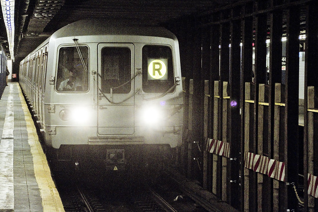
Btw, that’s the R line entering the 46th street station along Broadway in Astoria. The R line came online in this part of Queens back on the 19th of August in 1933.

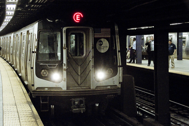
– photo by Mitch Waxman
That’s the E line entering Queens Plaza on its way towards Manhattan. The IND (underground) station at Queens Plaza also opened on August 19th in 1933, but back then it only ran as deep into Queens as Jackson Heights at Roosevelt Avenue. On the Manhattan Side, it went to what was once called Hudson Terminal, a spot which we refer to as Ground Zero these days. The E’s range was extended several times throughout the 1930’s until it achieved a route which extended deep into Queens. Cutbacks began in the 1940’s, and continue to this day on the E.
F 3.2, ISO 6400, 1/160th of a second, tungsten color temperature.

– photo by Mitch Waxman
The 23rd street Ely Avenue IND Station, over in Long Island City, opened on August 28 in 1939, about six years after the elevated IRT station “Court Square” was opened for business. That’s the M train coming into the station. The M line is part of the (in LIC and part of Manhattan) IND 53rd street line, which is a section of the IND Queens Boulevard line in terms of the larger system.
There you go.
F 2.8, ISO 5000, 1/160th of a second, tungsten color temperature.

– photo by Mitch Waxman
Over in Manhattan, at the deepest kind of a subway platform which one can mentally conjure, and at what has to be only 20-39 feet above hell itself – the 4 train illuminates one of those rotting concrete tunnels it inhabits while entering the scene. Notice how the train jockey is writhing whilst realizing he’s being photographed… hee hee. Why so serious, say I?
This station opened at two in the afternoon on the 17th of July in 1918. I’ve been using this line more and more often these days, as the less time the spent on the Subway the better, and the Lexington Express gets me to the Staten Island Ferry in Lower Manhattan just as quick as you can.
F 3.2, ISO 5000, 1/125th of a second, tungsten color temperature.

– photo by Mitch Waxman
Bowling Green in Lower Manhattan, and the 5 train is entering the tableau. This used to be the terminal stop for the Lexington line, when the station opened on the 10th of July in 1905. Service to Brooklyn also started in 1905. It’s an IRT station, just like 59th street. IND and IRT are terms which refer to the old dual contracts era of the Subway construction era, which have created the A and B divisions of the modern day MTA New York City Transit Authority.
F 3.2, ISO 5000, 1/200th of a second, tungsten color temperature.

– photo by Mitch Waxman
That’s the G train entering the Greenpoint Avenue stop in the shot above, and also showcasing the decidedly uncomfortable expression characteristic of an MTA subway employee who suddenly realizes he or she is being photographed while at work. Another of the August 19th of 1933 era lines in Brooklyn and Queens, the G is officially called the IND Crosstown Line by MTA insider and rail fan alike.
F 4.0, ISO 5000, 1/160th of a second, tungsten color temperature.

– photo by Mitch Waxman
An IRT train, the 7 line enjoys its elevated existence under the ever watchful burning thermonuclear eye of God itself, upon having entered Queens. The stop at which this shot was captured is the 40th street Lowery stop, which opened for business in 1917.
One is always amazed at the series of late dates upon which these stations opened, incidentally. Assumptions that the Broadway line through Astoria opened in the 1920’s are acknowledged, given the density of apartment houses along the line which are both admitted to and offered at this – your Newtown Pentacle.
F 7.1, ISO 250, 1/250th of a second, daylight color temperature.
“follow” me on Twitter- @newtownpentacle
trickling from
Those Astoria Tumbleweeds… they’re back.

– photo by Mitch Waxman
Friday the 3rd of January saw a humble narrator out early, as one had professional obligations to fulfill. While waiting for my breakfast sandwich to be assembled at a greasy spoon on Broadway, here in almond eyed Astoria, observation of a carefully placed and quite discarded Christmas tree occurred. It would have made the news if this coniferous corpse was placed in a bike lane, but instead…

– photo by Mitch Waxman
The ever reliable DSNY has posted an instructive page here, which describes the proper procedure for disposing of holiday cheer. The municipal organization has a large mulching operation set up to aid in the disposal of the seasonal cultivar, and no where in its list of specificities governing the process does it say “throw it into the middle of the street.” Ahh, Astoria.

– photo by Mitch Waxman
The purchase of breakfast complete, one did not have time to watch the thing roll about in the street. Rather a somewhat epic journey was undertaken, wherein the longest and most expensive possible route (using mass transit) to Brooklyn was undertaken. Why do you need to leave the Long Island, traveling through Manhattan, to arrive at a spot on the Long Island less than 7 miles from your starting point? It’s just silly.
“follow” me on Twitter- @newtownpentacle


