Posts Tagged ‘gowanus’
unsigned letter
It’s National Drive-Thru Day, in these United States.
– photo by Mitch Waxman
Ain’t nothing like a heat wave in NYC, huh? Regardless of tropical clime, nor distances involved, a humble narrator nevertheless surged forward into the wilds of Long Island’s western tip recently to gather photographs and experience the truculent realities of our time.
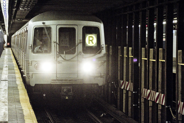
One left Point A in Astoria via the usual means, onboard the so called “R” or Broadway Local Line .
from wikipedia
The R Broadway Local is a rapid transit service in the B Division of the New York City Subway. Its route emblem, or “bullet”, is colored yellow since it uses the BMT Broadway Line in Manhattan.
The R operates local between 71st Avenue in Forest Hills, Queens and 95th Street in Bay Ridge, Brooklyn at all times except nights when it short turns at Whitehall Street–South Ferry in Lower Manhattan from Brooklyn.
– photo by Mitch Waxman
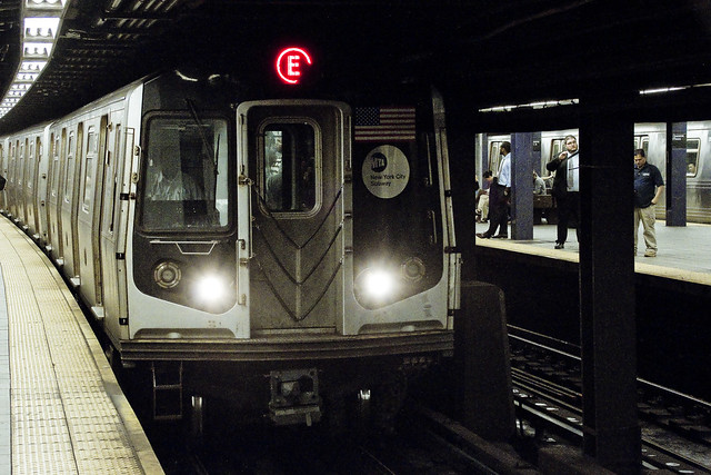
Ultimately, one sought to gain access to the Crosstown or “G” line, which the MTA folks annoyingly force one to enact two transfers to get to from Point A, despite the platform’s location less than a mile and a half from my starting point (and the fact that the G used to run through the same station which I caught the R at). Accordingly, at the sweltering bunker of dripping masonry which the MTA designates as “Queens Plaza,” one debarked the R and vouchsafed a single station ride upon the “E” – or Eighth Avenue Local Line – to the Court Square station where yet another transfer was enacted to access the G.
Urine, it smelled deeply of urine, at the Court Square station.
from wikipedia
The E Eighth Avenue Local is a rapid transit service in the B Division of the New York City Subway. Its route emblem, or “bullet”, is blue since it uses the IND Eighth Avenue Line in Manhattan.
The E operates at all times between Jamaica Center–Parsons/Archer in Jamaica, Queens, and Chambers Street–World Trade Center in Lower Manhattan, running express on the IND Queens Boulevard Line in Queens (except nights when it serves all stops) and local in Manhattan. E trains also serve two local stops in eastern Queens (75th Avenue and Briarwood) on evenings and weekends.

– photo by Mitch Waxman
My penultimate destination, on this particularly warm evening, was Sunset Park – which adjoins the legend choked streets of the Red Hook section of Brooklyn. One does realize, of course, that the R could have taken me all the way to this area which is called “Sunset Park,” but that would have multiplied my travel time due to a circuitous route which transverses all of Manhattan and a good chunk of Brooklyn.
The G discharged a humble narrator, vomiting me forth onto the platforms at the sky flung Smith/9th street station, high over the loathsome and shadow haunted Gowanus Canal. The Gowanus Canal smells of urine (and other things) as well, of course.
from wikipedia
The G Crosstown Local is an 11.4-mile-long (18.3 km) rapid transit service in the B Division of the New York City Subway. Its route emblem, or “bullet”, is colored light green since it uses the IND Crosstown Line.
The G operates at all times between Court Square in Long Island City, Queens and Church Avenue in Kensington, Brooklyn via the IND Crosstown and Culver lines. In Queens, it only serves two stations – Court Square and 21st Street, both in Long Island City – but previously served all stations to and from 71st Avenue in Forest Hills on the IND Queens Boulevard Line.
– photo by Mitch Waxman
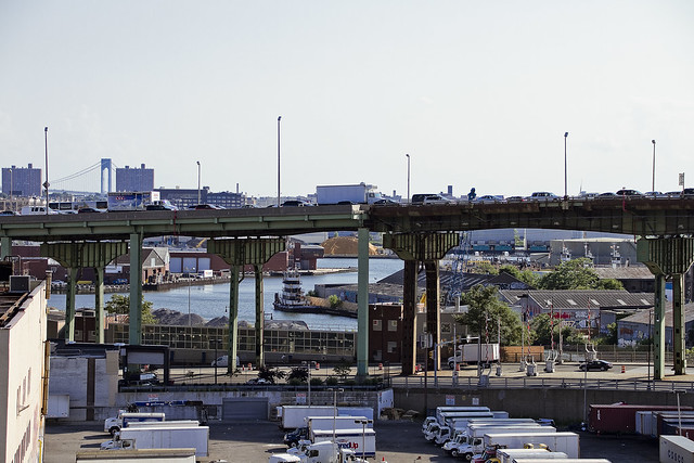
My plan was to pass through the “House of Moses” and under the Gowanus Expressway section of the Brooklyn Queens Expressway, exploiting the shaded path which is offered by this elevated roadway, and head south towards Sunset Park. It should be mentioned, incidentally, that this is perhaps the least pedestrian friendly area in all of Brooklyn. Brobigdagnian trucks whiz about at high speed, angry motorists lurch their vehicles to and fro in frustrated bursts, and the pavement is both shadowed by the expressway above and in a delitorious state of repair.
Also, there’s vampires hiding in the rafters of the Gowanus Expressway.
from nycroads.com
The Gowanus Expressway, which serves as the southern extension of the Brooklyn-Queens Expressway, also connects the Brooklyn-Battery Tunnel approach, the Prospect Expressway (NY 27), the Belt Parkway and the Verrazano-Narrows Bridge. Although guide signs and maps refer to this segment of I-278 as the Brooklyn-Queens Expressway, it is known locally as the Gowanus Expressway.
Beginning in 1939, Robert Moses oversaw construction of the Gowanus Parkway, an elevated highway placed on top of the pillars of the old 3rd Avenue BMT Elevated Line through the Sunset Park and Gowanus sections of Brooklyn. It would eventually become part of a limited-access parkway loop encircling four of the five boroughs. Since the Gowanus Parkway was to be constructed atop a pre-existing elevated facility, Moses had little trouble getting his project approved by the New York City Council.
However, the Gowanus Parkway would require more land for a wide roadway and entrance-exit ramps. This required the demolition of many homes and businesses along Third Avenue, a tightly knit block of Northern and Western European immigrants.

– photo by Mitch Waxman
There are charming sights to be found along the Gowanus Canal, I should mention, lest you think I’m prejudiced against the “Superfund Sister to the South” of my beloved Newtown Creek. Abundant waste transfer and oil distribution facilities, endemic pollution, lakes of unknown chemical constitution lurking just below the streets, untreated sewage oozing out of unmarked pipes? These are all the things I love.
One has never understood the appeal of “going to the country” and vacationing amongst the rural yokels. Camping? Are you insane? I’ve got a dry bed and a door that locks here in NYC, where I get to witness a looming infrastructure crisis and unfolding environmental apocalypse whenever I want to.
from wikipedia
The Gowanus Canal is a canal in the New York City borough of Brooklyn, on the westernmost portion of Long Island. Connected to Gowanus Bay in Upper New York Bay, the canal borders the neighborhoods of Red Hook, Carroll Gardens, and Gowanus, all within South Brooklyn, to the west; Park Slope to the east; Boerum Hill and Cobble Hill to the north; and Sunset Park to the south. It is 1.8 miles (2.9 km) long. There are seven bridges over the canal, carrying Union Street, Carroll Street (a landmark), Third Street, Ninth Street, Hamilton Avenue, the Gowanus Expressway, and the IND Culver Line of the New York City Subway.

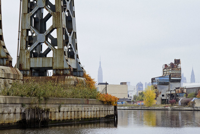
– photo by Mitch Waxman
That’s part of the Gowanus Canal, pictured above, as shot from the Hamilton Avenue Bridge and looking back north towards the Smith/9th street station which the G line disgorged me into. Used as I am to the wild expanses and geographic extent of Newtown Creek, my thoughts always turn to compactness when I’m at the Gowanus. Thing is, just like Newtown Creek and its tributaries – two of which the Gowanus would tuck neatly into – the canal interacts with ground water and flows beneath the streets via its connections with the sewer system. Just like Newtown Creek, many of the sewers connected to the Gowanus are in fact former tributary waterways which were converted and buried at the end of the 19th and start of the 20th centuries. Who can guess, all there is, that might be buried down there?
Additionally, both Gowanus Canal and Newtown Creek sport maritime industrial bulkheads along most of their length which are little more than artifacts of the Second Industrial Age, in our modern day NYC.
from nyc.gov
The Hamilton Avenue Bridge is a bascule bridge with two parallel leafs, one carrying the northbound roadway and the other carrying the southbound roadway. Most of the length of Hamilton Avenue runs below the elevated portion of the Gowanus Expressway, including the bridge. The bridge connects Smith Street and Second Avenue over the Gowanus Canal and is the first canal crossing north of the Gowanus Bay.

– photo by Mitch Waxman
Regardless of musings about the wasted space, lack of public access, and utter degradation of the air, water, and soil – one had somewhere to be, and a little bit of walking was required to get there. A humble narrator put his head down, leaned into a southerly declination, and scuttled off into the clouds of auto exhaust mixing with the humid air.
The Gowanus Expressway dwelling Vampires be damned, I needed to get to Sunset Park.
from wikipedia
A vampire is a being from folklore that subsists by feeding on the life essence (generally in the form of blood) of the living. In European folklore, vampires were undead beings that often visited loved ones and caused mischief or deaths in the neighbourhoods they inhabited when they were alive. They wore shrouds and were often described as bloated and of ruddy or dark countenance, markedly different from today’s gaunt, pale vampire which dates from the early 19th century.
Vampiric entities have been recorded in most cultures; the term vampire, previously an arcane subject, was popularised in the West in the early 19th century, after an influx of vampire superstition into Western Europe from areas where vampire legends were frequent, such as the Balkans and Eastern Europe; local variants were also known by different names, such as shtriga in Albania, vrykolakas in Greece and strigoi in Romania. This increased level of vampire superstition in Europe led to mass hysteria and in some cases resulted in corpses being staked and people being accused of vampirism.
Upcoming Tours and events
The Insalubrious Valley of the Newtown Creek Walking Tour, with Newtown Creek Alliance – Saturday August 5th, 11 a.m. – 1;30 p.m.
Century old movable bridges, the remains of a 19th century highway between Brooklyn and Queens, and explore two of the lesser known tributaries of the troubled Newtown Creek watershed. For the vulgarly curious, Conrad Wissell’s Dead Animal and Night Soil wharf will be seen and described, with NCA Historian Mitch Waxman – details here.
Brooklyn Waterfront Boat Tour, with Working Harbor Committee – Saturday August 12th, 6 p.m. – 8 p.m.
Explore the coastline of Brooklyn from Newtown Creek to Sunset Park, with NCA Historian Mitch Waxman, Andrew Gustafson of Turnstile Tours, and Gordon Cooper of Working Harbor Committee on the narrating about Brooklyn’s industrial past and rapidly changing present. – details here.
The Poison Cauldron of the Newtown Creek Walking Tour, with Newtown Creek Alliance – Sunday August 13th, 11 a.m. – 1:30 p.m.
Explore the hellish waste transfer and petroleum districts of North Brooklyn on this daring walk towards the doomed Kosciuszko Bridge, with NCA Historian Mitch Waxman – details here.
Two Newtown Creek Boat Tours, with Newtown Creek Alliance and Open House NY – Wednesday August 16th, 5 p.m. and 7 p.m.
The neighborhoods surrounding Newtown Creek are home to the densest collection of these garbage facilities anywhere in the city and collectively, the waste transfer stations around and along Newtown Creek handle almost 40% of the waste that moves through New York. Join Newtown Creek Alliance’s Mitch Waxman and Willis Elkins to learn about the ongoing efforts to address the environmental burden that this “clustering” has caused. – details here.
“follow” me on Twitter- @newtownpentacle
#SUPERFUN on May 31
Welcome to Newtown Creek.
– photo by Mitch Waxman
As promised – the big Monday Announcement!!! On May 31, I’ll be narrating on a boat tour of Newtown Creek for the Working Harbor Committee. WHC is offering a special $30 ticket price, discounted to $25 for seniors. It’s a two hour tour which will leave from Pier 11 in Manhattan at 11 a.m. I’m anticipating having a couple of other guest speakers onboard, but I’m still firming that up.
For tix’s to WHC’s morning tour with NCA Historian Mitch Waxman, on Newtown Creek. For group rates, or questions – contact Working Harbor Committee at workingharbor@aol.com

– photo by Mitch Waxman
So what could be more fun than visiting a superfund site? Visiting two, of course.
A separate and distinct excursion will leave from Pier 11 at 1:10 p.m., as Working Harbor Committee’s afternoon trip to the Gowanus Canal embarks. Last I heard, it’s the same deal as Newtown Creek for pricing and tix, and it’s a two hour tour as well.
Click here for tix to WHC’s afternoon tour of the Gowanus Canal.
Newtown Creek is better, of course, because it’s mine.
“follow” me on Twitter- @newtownpentacle
blind alley
It’s nice just to be amongst people.

– photo by Mitch Waxman
The tour schedule is underway again, which has been going pretty well. So far, it’s been a full house on every excursion. Accordingly, your humble narrator has found himself all over the City of Greater New York (avoiding Manhattan whenever possible) and one has been waving the camera around at a vast variety of subjects. As you’re reading this, I’m likely in historic Newtown (aka Elmhurst) searching for certain signs and portents left behind by earlier generations.
I was in South Brooklyn recently, for an opening reception of the “Combined Overflow” show at Proteus Gowanus, which I was invited to hang a few prints in.
from wikipedia
The English loanword “wanderlust” was already extant in the German language dating as far back as Middle High German. The first documented use of the term in English occurred in 1902 as a reflection of what was then seen as a characteristically German predilection for wandering that may be traced back to German Romanticism and the German system of apprenticeship (the journeyman), as well as the adolescent custom of the ‘Wanderbird’ seeking unity with Nature.
The term originates from the German words wandern (to hike) and Lust (desire). The term wandern, frequently misused as a false friend, does in fact not mean “to wander”, but “to hike.” Placing the two words together, translated: “enjoyment of hiking”, although it is commonly described as an enjoyment of strolling, roaming about or wandering.

– photo by Mitch Waxman
While at Proteus Gowanus, I decided to snap a couple of exposures of the lamentable Gowanus Canal as witnessed from the Union Street Bridge. Call me a “size queen,” but seriously – compared to Newtown Creek – Gowanus seems pretty compact. Attempts to get to know this waterway are being undertaken, as business carries me to South Brooklyn at least once a month these days.
from nyc.gov
The Union Street Bridge is a double leaf Scherzer rolling lift bascule supporting Union Street over the Gowanus Canal in the borough of Brooklyn. The bridge has two vehicular traffic lanes, each approximately 17 feet wide, and two sidewalks, each 6 feet wide. Both traffic lanes carry eastbound traffic.

– photo by Mitch Waxman
These two views are from either side of the Union Street bridge, and depict a landscape unfamiliar. On Newtown Creek, I can see through time and tell you about the outlines of long demolished chimneys and mills, whereas here at the Gowanus – I’m just a visiting tourist seeking the vicarious. That’s nice, I tell you. Something to learn about, new rocks to turn over, and a world which I do not know.
from wikipedia
The Gowanus Canal, also known as the Gowanus Creek Canal, is a canal in the New York City borough of Brooklyn, geographically on the westernmost portion of Long Island. Connected to Gowanus Bay in Upper New York Bay, the canal borders the neighborhoods of Red Hook and South Brooklyn to the west, Park Slope to the east, and Sunset Park to the south. It is 1.8 miles (2.9 km) long. There are seven bridges over the canal, carrying Union Street, Carroll Street (a landmark), Third Street, Ninth Street, Hamilton Avenue, the Gowanus Expressway and the IND Culver Line of the New York City Subway.
There are two public Newtown Creek walking tours coming up, one in LIC, Queens and one in Greenpoint, Brooklyn.
Glittering Realms, with Atlas Obscura, on Saturday May 17th.
Click here for more info and ticketing.
Modern Corridor, with Brooklyn Brainery, on Sunday May 18th.
Click here for more info and ticketing.
“follow” me on Twitter- @newtownpentacle
hastily blocked
As Johnny Cash said “I been everywhere, man.”

– photo by Mitch Waxman
Over the last few weeks, your humble narrator has found himself wandering through every borough, except the Bronx, and many marvels have been witnessed. Let’s face it, if your eyes are open, NYC is in fact a place of wonders. Just have to learn how to see, and remember not to get jaded by it all. An annoying trait shared by all members of the human infestation hereabouts is to render the familiar as ordinary, and to accept the built environment as pedestrian or ordinary.

– photo by Mitch Waxman
This is Hamilton Avenue, down by the Gowanus, which is one of the many spots in NYC which strike one such as myself dumb. The aggregate hours of human activity required to create a spot like this, just producing the steel and concrete which form the high flying Gowanus Expressway above or the draw bridge below, leaves me aghast.

– photo by Mitch Waxman
My beloved Newtown Creek, seen at night from the Pulaski Bridge, reveals trillions of hours of planning and work. The shield wall of Manhattan notwithstanding, this tableau visualizes the complete reshaping of a waterway to suit the needs of men, and for one such as myself – the absence of historic bridges and the unseen presence of an entire subway line are keenly felt. Wow.
There are two public Newtown Creek walking tours coming up, one in Queens and one that walks the currently undefended border of the two boroughs.
DUPBO, with Newtown Creek Alliance and MAS Janeswalk, on May 3rd.
Click here for more info and ticketing.
Modern Corridor, with Brooklyn Brainery, on May 18th.
Click here for more info and ticketing.
“follow” me on Twitter- @newtownpentacle
mentality and resource
A humble narrator will be live in meatspace at Brooklyn Brainery tonight.

– photo by Mitch Waxman
Pictured is the view from the Smith 9th street station in South Brooklyn, looking down upon the fabulous Gowanus. Business has been calling me down this way all through the end of 2013 and beginning of 2014. For the moment, at least, it appears that I’m going to be a regular visitor, so a bit of curiosity about the locale has been blooming in that withered carbuncle which beats within my chest. In no way do I plan on developing the intimacy with this superfund site that one enjoys with Newtown Creek, but there are things to see down here, I tell you. A point of listening to H.P. Lovecraft’s “Horror at Red Hook” is made, and a preference will be stated for the Audiorealms produced (and Wayne June narrated) reading of the unabridged text.

– photo by Mitch Waxman
I think that this is the Hamilton Avenue Bridge in an open position which we’re seeing here, but I might be wrong. Most of my experience with this part of Brooklyn involved driving over it, via the Gowanus Expressway, on my way from the Flatlands Canarsie area to either the Battery Tunnel or one of the East River bridges. I’m not looking for one of you, lords and ladies, to fill me in. It is a curse knowing too much, and the joy of discovering something new – at least to me – has become something of a rarity these days. I’m saving the entire Bronx for future usage, for instance. I did wait around for awhile to see what sort of maritime traffic had called for the opening, but nothing appeared.

– photo by Mitch Waxman
One of my back burner projects, the kind that never really gets started and is seldom finished, has been to track down “Lovecraft in Brooklyn.” The fellow lived here for an interval, which by all reports he did not enjoy.
The building which “Cool Air” was set in still stands on 14th street in Manhattan, and was observed in the appropriately named post “Cool Air.”
The Flatbush Dutch Reformed Church, which Mr. Lovecraft reportedly vandalized, was visited in the post “frightful pull.” I’ve even located the Suydam family tomb in Greenwood Cemetery, burial place of an antagonist from “The Horror at Red Hook itself.”
“follow” me on Twitter- @newtownpentacle


