Posts Tagged ‘Monongahela River’
Hot Metal, 3 Rivers Heritage Trail
Tuesday

– photo by Mitch Waxman
The path which the Monongahela River enjoys is somewhat serpentine in nature, prior to the waterway’s juncture with the Allegheny River, where they mutually become the Ohio River nearby Downtown Pittsburgh. Last week, I drove the Mobile Oppression Platform (the Toyota) over to a neighborhood called the Southside Flats and parked in a lot associated with a park and the Three Rivers Heritage Trail. The MOP was left directly beneath the Birmingham Bridge, pictured above.
It’s a young bridge for this section of the world, having been opened for business in 1977. It’s another bowstring arch bridge, not unlike the Fort Penn bridge discussed last week. The fact that it’s not painted yellow indicates that it’s a state – rather than a city – bridge. My plan for the afternoon was pretty simple – I’d walk eastwards along the trail, cross the river and then walk westwards, whereupon I’d circle back to the MOP. It was overcast in Pittsburgh, with roiling clouds bolting around up in the vault, and the temperatures were comfortable and in the mid 50’s.

– photo by Mitch Waxman
This is another one of the sections of Pittsburgh where there used to be a steel mill, I’m told. The trail itself follows active freight rail tracks on the south side of the river. In tomorrow’s post, the north side of the scene will be explored, but for the first half of my walk it was all about the south side and getting to where my crossing would be found.
There’s gigantic infrastructural elements available for inspection and appreciation along the way – storm sewers, enormous concrete and iron retaining walls that keep the slopes of sedimentary soil deposits from sliding into the river. One section had steel plates holding up a wall of soils, with the steel plates bolted into place with giant lug nuts that were the size of dinner plates.

– photo by Mitch Waxman
That’s the 1887 vintage Hot Metal Bridge. During the Second World War, 15% of American steel production would travel over it on the rails. In 2000 AD, it was converted over to vehicle and pedestrian/bike usage. Its “official” name is the “Monongahela Connecting Railroad Bridge and Hot Metal Bridge.” On the path approaching it, there’s historic signage which describes the steel industry and the railroads which served it.
There’s post industrial development everywhere you look in this zone, and a few large corporate anchors are located nearby, including the clothing company American Eagle Outfitters.

– photo by Mitch Waxman
On the Hot Metal Bridge’s pedestrian path, which is completely separated from the vehicular lanes, and heading north – that’s where this shot was gathered. I didn’t have any particular goal for the afternoon other than kicking my feet about and getting some exercise, but I was able to piece together a mental map of where I was scuttling based around prior explorations – which I’ve described here – of the Monongahela Valley. Locally, it’s referred to as the Mon Valley by the politicians, but when they say that it’s usually in reference to the still quite industrial areas to the east like Clairton and Braddock.
There were just a few other people on the bridge. A bike rider or three, joggers, one or two other pedestrians. No dogs.

– photo by Mitch Waxman
This one looks back towards the south side of the river across the Hot Metal Bridge. My original plan was to circle back to the south side and the MOP using the Birmingham Bridge… but more on that tomorrow.
The north side has quite a different circumstance than the south does, with high speed roads like I-579 riding on elevated structures and an industrial and commercial zone. When you get to the north side, the Three Rivers Heritage trail is renamed as the Eliza trail to commemorate the J&L Steel mill which was located here. This bridge is also part of the Great Allegheny Passage trail.

– photo by Mitch Waxman
On the north side, I turned westwards. The neighborhoods around this intersectional area are Oakland and the Hill District. The terrain here is difficult due to its verticality, and I can tell you that it’s a real challenge to climb these hills on foot. Luckily, the path I was walking on was graded for rail, meaning one foot of elevation for every hundred feet horizontally.
Tomorrow, I find myself walking through the sort of place which most would logically go looking for my corpse, if I’d gone missing.
“follow” me on Twitter- @newtownpentacle
Buy a book!
“In the Shadows at Newtown Creek,” an 88 page softcover 8.5×11 magazine format photo book by Mitch Waxman, is now on sale at blurb.com for $30.
Fort Pitt Bridge, part 2
Wednesday

– photo by Mitch Waxman
As described yesterday, one required a bit of exercise and thereby the Fort Pitt Bridge’s extremely icy pedestrian walkway beckoned. It was literally below freezing out, but a humble narrator was wrapped up tight in winter garb, including a brand new winter coat. A conscious decision was made to travel a bit lighter than usual, with just two lenses and no tripods or other extraneous gear to slow me down. As it turns out, I only needed the one lens (24-105mm).
After crossing over the Monongahela River, the walkway is set onto an elliptical path which eventually brings one back to the sidewalk nearby Pittsburgh’s famous Duquesne Incline.

– photo by Mitch Waxman
Alluding to Tolkien – one lens to rule them all – is what I’ve been missing on the Canon RF mount since I upgraded from my old rig, which was a Canon 7D. The Canon R6 I’m using these days is in all ways a superior digital appliance to the former camera, but there are few if any third party lenses available for it. On the 7D, which is a “crop sensor” model, I almost always had a Sigma 18-300mm zoom lens attached to it for general “photowalk” usage. That lens, and several others in my kit, are designed specifically for the crop sensor and not the full frame chip inside of the R6. This sort of “all in one” range suggests that it would be a crappy lens, but I liked it for its versatility and once you got to know the thing and where and when it failed, it was actually pretty reliable. I find myself using the 24-105 a lot here in Pittsburgh.
Saying that, I’m not unhappy with what I’m getting from the 24-105mm – I mean, it’s a Canon L series lens with a red band and everything – but I miss the option of going from ultra wide to telephoto with just a twist of the lens barrel. Supposedly Canon isn’t licensing the RF mount to anyone right now. That’s a shame, since there’s some pretty amazing glass out there from Sigma and others in the Nikon and Sony mount spaces.

– photo by Mitch Waxman
That’s the Fort Pitt Tunnel that the vehicle traffic is hurtling into. Right around this spot is where I ended up conversing with some bloke about the news of the day and we both landed on how cold it was. There wasn’t too much in the way of pedestrian or bike traffic on this particular afternoon, but it was – after all – January in Pittsburgh.
It has been fairly difficult to get out for my every other day walks for the last couple of weeks due to the January factor. Rain, snow, snow showers, rain, polar vortex, rain…

– photo by Mitch Waxman
When time and opportunity present, though, I get my butt moving! The plan for the rest of the afternoon involved scuttling down the Monongahela River shoreline towards the Station Square “T” light rail stop. This pathway leads into a connection with the Three Rivers Heritage Trail, which is another one of the many (fantastic) rail-to-trail pathways that snake around the city. A couple of weeks ago, the Great Allegheny Passage’s trail in Homestead was discussed – part 1, part 2, part 3.
Just the other day, I was walking down the other side of the Monongahela River, on the golden triangle/city side. You’ll see those shots next week, but that’s where the waterfront trail’s path goes nowhere near the water and you’re separated from it by a massive highway and several waterfront industrial and commercial parcels. I was ecstatic about this, of course, since I got to walk around and photograph the footings of bridges and highways. I’ll show you all that next week, I think.

– photo by Mitch Waxman
We are just about done with the moving process at this point. Furniture is in the house, I’ve now got a Pennsylvania Driver’s License, and have learned about seasonally available regional baked goods. Ever had a Pączki? One is looking forward to spring, exuberantly. The moving process consumed my entire autumn and winter. Y’know, you’d think moving from one state to another would be simple, huh?
The last major process we have to handle involves transferring my car registration and plates over to Pennsylvania ones. When that’s done, major combat operations will have concluded and I will realize the peace dividend of having fewer “have-to’s” listed in my column on a white board somewhere.

– photo by Mitch Waxman
I kept on hoping for a train to roll through, which would have really made the shot above sing. As continually repeated – I’m scouting right now. Figuring out where the shots are, how I get there, what time of day would be best – all that. So far, I haven’t had very much luck as far as timing goes when it comes to freight rail traffic. I’m no train spotter, or railfan as it were, but damn… I wish there had been a CSX train set rolling through for this one.
Tomorrow, a few more shots from my walk along the Monongahela River here in the Paris of Appalachia.
“follow” me on Twitter- @newtownpentacle
Buy a book!
“In the Shadows at Newtown Creek,” an 88 page softcover 8.5×11 magazine format photo book by Mitch Waxman, is now on sale at blurb.com for $30.
Fort Pitt Bridge, part 1
Tuesday

– photo by Mitch Waxman
A man has to have a code, I opine. One of the many points in my personal credo involves getting out every other day to point the camera at things and walk around. Back in NYC, when a spell of ugly weather was being described by the meteorological enthusiasts, I’d often say to Our Lady of the Pentacle that “I’m going to go ride the trains” and I’d take off for the 7 line, and spend a few hours hopping on and off of the train getting shots of NYC’s most photogenic subway. Not an option, now, of course.
Amongst the many other bits of wisdom my code offers is “it’s better to regret something you’ve done than something you didn’t do” and that “if you regret something you’ve done, you can’t take it back or apologize to the party you’ve wounded so don’t feel guilty, just don’t do that thing again.” Also – “stop fucking up.” I do realize how sociopathic that sounds, but it’s true.

– photo by Mitch Waxman
“Nothing matters and nobody cares” was added into the code during the COVID period. “Don’t skimp on shoes, hats, or eyeglasses” is another bit of sage wisdom I can offer. One of my big revelations from the last year involves a concept I call “the conservation of energy.”
Expending energy into fixing a closed system is a waste of effort. You could put all the effort into it you want, but if a closed system is designed to fail, expanding the system with an input of energy isn’t going to change that. Sometimes it’s just best to do or say nothing at all. One of my “things” these days is to listen to people arguing about some hot button political topic of the day and then announce “I’ve got an opinion about that,” whereupon I leave the room without sharing it.

– photo by Mitch Waxman
The Fort Pitt bridge in Pittsburgh, on the other hand, is quite material and doesn’t require a personal code of conduct other than not vandalizing or jumping off of it. The bridge dates back to 1959, and connects downtown Pittsburgh to its southern surroundings via Interstate 376 which is carried on its two decks. The pedestrian walkway is attached to the lower deck, overlooking the confluence of the three rivers. Interstate 376 traffic moves to and from the Fort Pitt Tunnel (opened in 1960) which is punched through the base of Mount Washington. A notable destination on the other side of the tunnel for some of this traffic flow is the Pittsburgh International Airport. This is the third bridge to span the Monongahela River in this spot, and the first one was erected in 1877. According to 2018’s official numbers, the bridge handles about 150,000 vehicle trips a day.
Since I’ve been living here in Pittsburgh, walking over this one has been on my to-do list.

– photo by Mitch Waxman
As you can see, zero effort was made to clear the walkway of snow and ice by its stewards, and the footing was quite treacherous. Couple that with waist high fencing along the drop to your death side of the path, and I made it a point of sticking close to the girders that support this double decked steel bowstring arch bridge should a handhold be required.
My plan for the day, which was mentioned in yesterday’s post, was to leave the car back at home and use the T light rail to get to and from HQ. After crossing the bridge, I’d head towards another stop on the T that’s less than a mile from where the pedestrian walkway would return me to Terra-Pennsylvania.

– photo by Mitch Waxman
While you’re walking along the path, just over your shoulder is an interstate carrying hurtling vehicles. As I’ve mentioned in the past, driving here is very, very different than it is back in NYC. I’ve got a practiced advantage when it comes to merging lanes, parallel parking, and a general obeisance to traffic law. Pennsylvania drivers seem to believe that the speed limit is a mere suggestion, or perhaps a starting point. I’ve driven this path before, and had people shoot past me at 70 while trying to handle a three lane merge within a few hundred feet. Brrrr.
Another one of my sage bits of wisdom is “you’ll get there when you get there, what’s the rush.” I should mention that I’m not at all naturally wise, instead there isn’t a mistake you can make that I haven’t already made. Remember rule number 4 – “stop fucking up.”

– photo by Mitch Waxman
This particular section of the walkway, leading down and away from the bridge towards the Duquesne Incline, was a positive skating rink. Hard packed ice with a layer of dry powder snow sitting loosely atop it. Luckily, I’m used to dealing with uneven, unmaintained, or challenging terrain.
More tomorrow at this – your Newtown Pentacle.
“follow” me on Twitter- @newtownpentacle
Buy a book!
“In the Shadows at Newtown Creek,” an 88 page softcover 8.5×11 magazine format photo book by Mitch Waxman, is now on sale at blurb.com for $30.
Investigating the GAP, part three
Friday

– photo by Mitch Waxman
The Mon Valley Works – Edgar Thomson Plant. That’s what the U.S. Steel outfit calls this steel mill, parts of which date back to 1875 and Andrew Carnegie. It’s where the United States’ first Bessemer Converter was installed, and is a cornerstone of our American story.
Having never witnessed this sort of thing in person before, the Mon Valley Works absolutely blows my mind. Wow. I’ve seen Battleships, and Air Craft Carriers, and mega massive sewer plants, and power generating stations, and petroleum refineries, and waste transfer stations, and port infrastructure – but I’ve never seen anything like this before. Blown.

– photo by Mitch Waxman
I had carried all the gear I use with me onto the Great Allegheny Passage trail, and got busy with the tripod and everything else as soon as a decent point of view of the Mon Valley Works appeared. Next time I visit the GAP, I’m planning on entering the trail from the Duquesne side to explore what you can see from that set of angles.
I’m also going to return to this position for early morning and late afternoon light when it warms up a bit, but I fear that spring and summer will create problems for me due to the vegetation being clad with leaves.
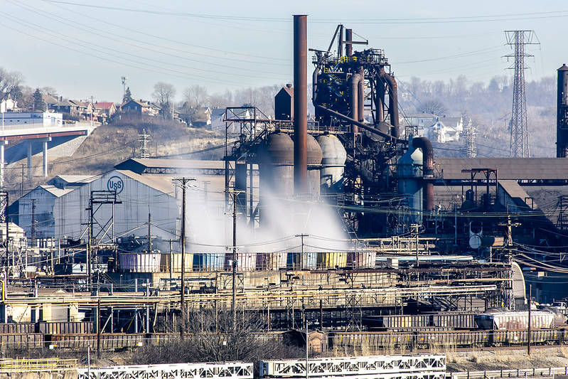
– photo by Mitch Waxman
Even across the Monongahela River, and pretty distant, the Mon Valley Works are loud. Massive fans are at work for the heat exchangers, and the furnaces also are beaming out vibration and sound. The plant is also pumping out a terrific amount of sulfur dioxide, as it runs off coke and coal, so there’s a smell of rotten eggs which is omnipresent in the air.
I’m told that air quality in the Pittsburgh area can be awful, largely because of these coal fired heavy industries. So much so that there’s a website which tracks the plumes of pollutants that the three big steel mills pump into the atmosphere. Prevailing wind and economic geography decide who gets to breathe the stuff in. These steel mills, however, form and produce the building blocks for other industrial sectors, and always have. Somebody always pays the price for “progress.” It’s something to remind yourself about as you consume new manufactured products in the manner of a raging wildfire.
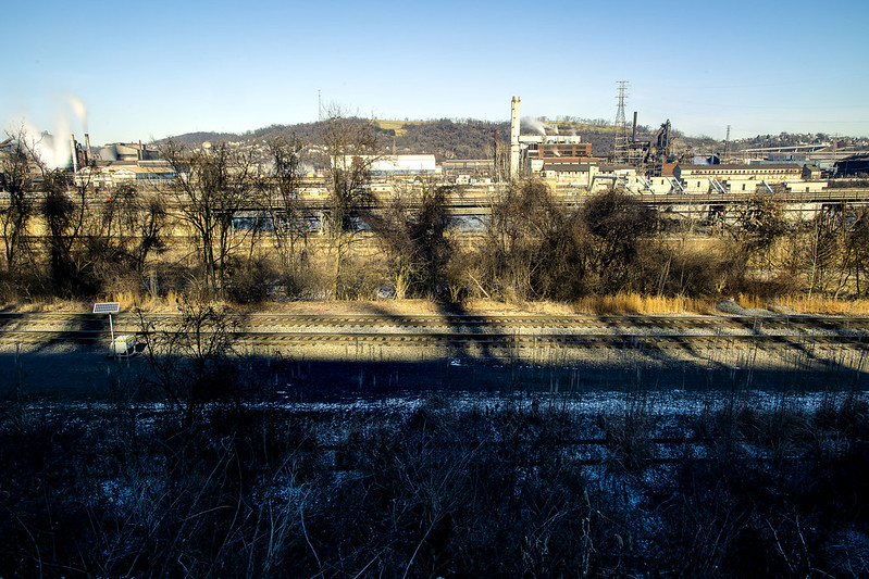
– photo by Mitch Waxman
On the side of the Monongahela River that the GAP trail follows, you’re a pretty decent distance away from the shoreline. I did a wide shot to illustrate that, and to pass on the advice that if you want to get shots of the plant, bring a zoom lens with a not insignificant range.
As mentioned, those trees are going to block out the view during the warmer months. This was my turnaround point for this walk, as I’d have about another 4 miles to walk to get back to the Mobile Oppression Platform (my nickname for the car) which was parked at the Homestead Pump House. How did I come up with “Mobile Oppression Platform”? First, I owe a debt to the writers of the Futurama cartoon, secondly… have you ever talked to the bicycle people in Queens? Ever heard a car described as a two ton murder machine? I have, and took inspiration from the bellicose posturing they offered. If “two wheels good, four wheels bad” is your motto, I figured I’d give my car a name to piss you off. I’m a Dick like that.
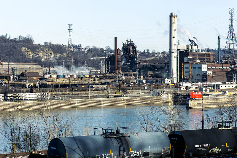
– photo by Mitch Waxman
There’s so many things I want to get close up to in the shot above, including the Army Corps of Engineers lock and dam at the right side of the shot. After a disastrous flood in the 1930’s, the USACE installed a series of locks and dams on the rivers leading to Pittsburgh to control the waters. There are multiple USACE lock and dam facilities in the Pittsburgh area which I’m “kvelling” to get closer to.
I packed up my more esoteric gear after this one, reverted back to handheld shooting mode, and started retracing my steps back to the Mobile Oppression Platform in Homestead and my ride back to HQ.

– photo by Mitch Waxman
On my way, I cracked out a few more shots, and was passing by the defunct Carrie Furnace just as the light became a bit kinder. As mentioned in the first of these posts, it was fantastic to walk a fairly long distance again. It’s been a couple of months, what with the move and the setting up of housekeeping and all that, since I’ve had the chance to just scuttle about and see these sort of things.
Next week, something different at this – your Newtown Pentacle.
“follow” me on Twitter- @newtownpentacle
Buy a book!
“In the Shadows at Newtown Creek,” an 88 page softcover 8.5×11 magazine format photo book by Mitch Waxman, is now on sale at blurb.com for $30.
Investigating the GAP, part two
Thursday
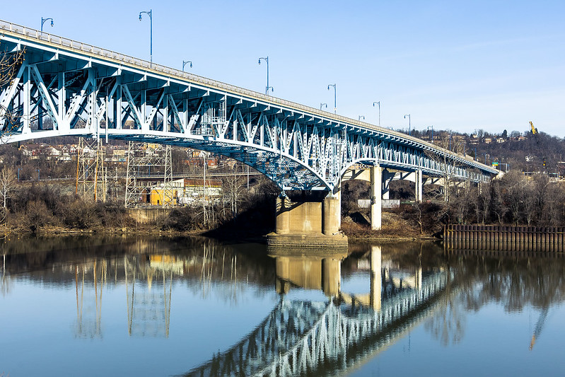
– photo by Mitch Waxman
As described yesterday, one parked the Mobile Oppression Platform at the Homestead Pump House’s parking lot and began a longish walk on the Great Allegheny Passage “rail-to-trail” pathway. Rail to trail is one of the options for what to do with the right of way of a railroad line which is no longer active. In the case of the GAP, the rail bed has seen the ties and actual rails removed and the ground either paved or covered with crushed limestone. It’s an easy walk, due to the grading that the rail engineers employed when laying out these right of ways (ROW), which is essentially a change of one foot in elevation for every hundred feet horizontally. The GAP trail in the Pittsburgh area which I was on starts in Homestead and doesn’t re-emerge onto the streets until you reach the community of Duquesne, which is many miles away.
I had a destination and “turn around point” in mind, for this scouting mission, which was more or less equidistant between Homestead and Duquesne. This trail was thereby fairly easy walking, and there was lots to see along the Monongahela River, which the GAP trail follows.

– photo by Mitch Waxman
Back in NYC, I’d often be asked where I’d want to go if time travel were possible. My response is usually “if you stepped out of your time machine into the late 19th century NYC, you’d have a knife slid into you within about 15 minutes.” Here in Pittsburgh, other than dodging freight trains hauling coal and coke at breakneck speeds, you’d have a different time travel problem – breathing. There are still operating steel plants here, but their emissions are a fraction of what would have once been found along the Monongahela Valley. I should mention that the emissions are an ongoing problem, however, and that the U.S. Steel people are often fined for violations of the Clean Air Act.
Mark Twain’s quote about Pittsburgh in 1884 reads “After our show, last night, we visited Mount Washington and took a bird’s eye view of your city by moonlight. With the moon soft and mellow floating in the heavens we sauntered about the mount, and looked down on the lake of fire and flame. It looked like a miniature hell with the lid off. It was a vision. A wonderful vision. It tended to frighten. The view is not as deliciously beautiful as one would suppose. If one can be calm and resolute, he can look upon the picture and still live. Otherwise, your city is a beauty.”
– photo by Mitch Waxman
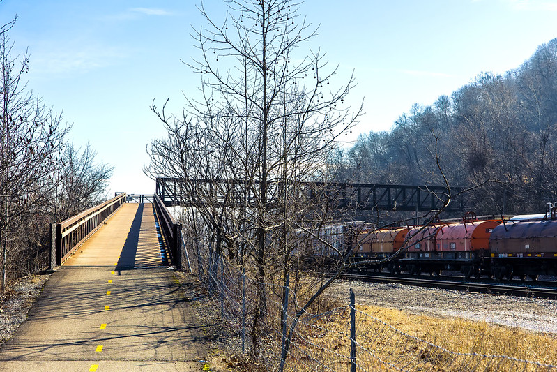
About a mile or so onto the trail, an overpass bridge is encountered, one which I’m told was added to the equation when the GAP trail was created. It allows transit over the active freight tracks the GAP follows from Homestead, and on the other side of the thing the trail continues along on an earthen shelf set in along a steep slope.
This bridge was one of the things which drew me in, what a great place to observe and photograph trains from, huh?

– photo by Mitch Waxman
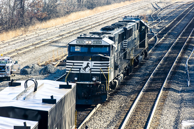
Norfolk Southern, like CSX, emerged as a dominant player in American Rail after the Conrail years and was formed out of several smaller operations. Their rolling stock heraldry is black and white, with a horse rearing up in silhouette acting as their logo. They’re pretty active in this region, and others.
There was a train set just sitting and waiting for its engine to show up, which luckily enough happened just as I surmounted the overpass bridge. A couple of workers were flipping the track switches around, and the engine was moving into position to couple with the train set.
– photo by Mitch Waxman
One could have stood on that overpass all day, photographing the comings and goings of the rail people. I probably will when the weather is warmer and I’ve packed a lunch. For this scouting mission, however, I still had a fairly decent amount of walking to do before I got to what I was actually seeking.
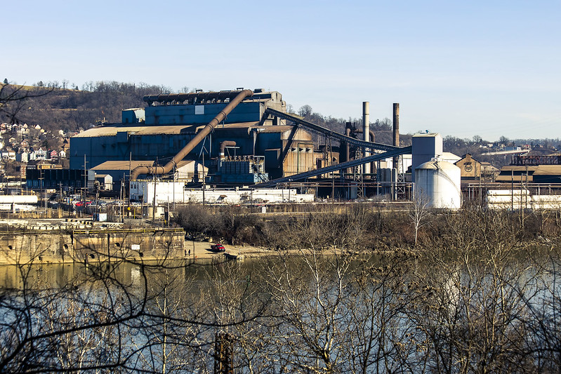
I haven’t been the same since visiting Braddock and seeing the Mon Valley Works steel plant. A need not unlike hunger demanded that I photograph it, which was a difficult thing to do from the landward side in Braddock. I wanted the river in the shot, as well. The GAP is the first location I’ve found so far that allows for this.
– photo by Mitch Waxman
I generally scuttle along at a comfortable pace, covering about two and change miles in an hour. Two hours into this walk, I finally arrived where I wanted to be. I had to find spots where the tree line wasn’t occluding my view of the U.S. Steel Mon Valley Works, but that did it take me long.
Tomorrow, the sort of shots I was looking for.
“follow” me on Twitter- @newtownpentacle
Buy a book!
“In the Shadows at Newtown Creek,” an 88 page softcover 8.5×11 magazine format photo book by Mitch Waxman, is now on sale at blurb.com for $30.


