Posts Tagged ‘newtown creek’
cluster around
Happy Labor Day.

– photo by Mitch Waxman
A humble narrator is taking a break this week, and single images will be greeting you sans the verbose drivel they’re normally accompanied by. It’s a rather busy week that I have ahead of me, but look for a strange old man wandering about the concrete devastations of the Newtown Creek with a camera. That’ll likely be me.
Tours and Events
Dutch Kills Dérive. Free!
Saturday, September 8, 2018, 9:30 AM – 12:30 PM with Flux Factory
Drowning in our own muck and mire, modern society must transmute its existence into that of an allegorical baptism in order to emerge a society of water protectors. The historic facts of exactly how our civilization has transformed the historic Dutch Kill waterway into a sewershed will act as both a numbing analgesic and a point of illumination. Tickets here.
“follow” me on Twitter- @newtownpentacle
malignity expressed
Nighted travels on the Newtown Creek.

– photo by Mitch Waxman
In yesterday’s post, I described the… nana nana nana Bat Boat!…. excursion I joined in with that my pals at Newtown Creek Alliance and NYC Audubon had organized which saw some three dozen bat enthusiasts take to the water in search of the children of the night. Today, here’s a few shots I cracked out on the way back to the North Brooklyn Boat Club dock in Greenpoint found alongside the Puslaski Bridge.

– photo by Mitch Waxman
From the “operating the camera” POV, these were actually kind of difficult shots to gather. It was crazy dark, as there aren’t many light sources directed at the water, and when there are they’re explosively bright like the ones on the Kosciuszcko Bridge. Generally speaking, I was using two of my “night lenses” which offer apertures as wide as f1.8.
Shooting “wide open,” however, introduces an extremely shallow depth of field into the shots. It’s quite the endeavor to find a focal point which offers an acceptable level of sharpness to the entire shot at these settings. Things were further complicated by the fact that I was in a giant canoe with six other people who were all rowing.

– photo by Mitch Waxman
A lot of the “shooting in the subways” stuff I do is in preparation for opportunities like this, which in the past have produced few or no usable shots. Practice, practice, practice – that’s how you get to Carnegie Hall.
Oddly enough, for the last few weeks, I’ve found myself shooting at f1.8 in bright sunlight, with insanely fast shutter speeds like 1/6000th of a second. What can I say, I like to “mix it up.”

– photo by Mitch Waxman
Frequent commenter George the Atheist asked yesterday, in a comment, about the safety aspect of paddling around in Newtown Creek. I offered a short reply, but here’s the official story:
The stuff you really have to worry about are the bottom sediments, the so called “black mayonnaise” which is about 20-30 feet down. If you’re coming into contact with that, you’ve got a whole other series of problems going on which involve a lack of buoyancy and oxygen deprivation. As far as the biological activity in the water, that’s determined ultimately by the last time that it rained, and whether or not that rain has triggered the “combined sewer outfalls” to release untreated wastewater into the creek.
My pals at North Brooklyn Boat Club who were running the expedition are seriously good at their jobs, and everybody out with us were wearing life vests. Additionally, T. Willis Elkins of North Brooklyn Boat Club (and NCA project manager) is in charge of the water testing program at NCA and if he says its “Kosher” to go out paddling you can take that to the bank.

– photo by Mitch Waxman
Saying that, you’d definitely want to wash up after paddling around and certainly before picking up a chunk of food and sticking it into your mouth. In my mind, you’d want to do that anytime you eat, especially after engaging in hand shaking activities with people you meet.
I hate that plague passing custom, as a note, especially when I’m doing a tour and thirty strangers all want to shake hands. One insists on touching elbows instead, if need be.

– photo by Mitch Waxman
As we were returning to the dock at North Brooklyn Boat Club, I whipped out a pocket flashlight and illuminated this juvenile Night Heron. The bird then proceeded to lunge at us, aiming its path at my head.
Everyone, and every thing, hates me.
Tours and Events
Canal to Coast: Reuniting the Waters Boat Tour. Only $5!
Thurs, August 30, 2018, 6:30 PM – 8:30 PM with Waterfront Alliance
Learn about the origins of Brooklyn’s Erie Basin as the Erie Canal’s ultimate destination, and its current role as a vital resource for maritime industry on this guided tour of Red Hook’s Erie Basin and the Brooklyn working waterfront, departing from and returning to New York Water Taxi’s Red Hook Dock. Tickets here.
“follow” me on Twitter- @newtownpentacle
well marked
Nana nana nana, Batboat!

– photo by Mitch Waxman
So, Sunday last, my pals at Newtown Creek Alliance and NYC Audubon set up an event which would see a group of three dozen Brooklyn bat enthusiasts climb into canoes at dusk and ply the lugubrious waters of the Newtown Creek in search of urban bats. How, I ask, could a humble narrator not want to come along?
Bat Boat!

– photo by Mitch Waxman
I was in one the two gigantic canoes maintained by the North Brooklyn Boat Club for such endeavors, and since I make great ballast, was sitting up front in the bow of the thing. All told, we had seven canoes out on the water.
Bat Boat!
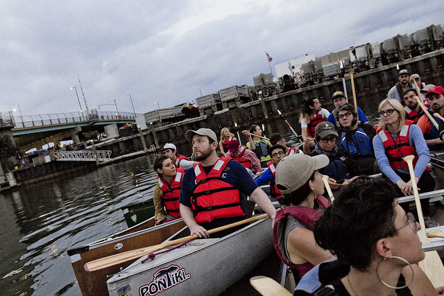
– photo by Mitch Waxman
The Audubon people were all geared up with electronic bat detectors (ultrasonic microphone doohickeys) and other frammistats. Bat experts were on hand to answer questions, and copies of “Bat International” magazines offered.
Bat Boat!

– photo by Mitch Waxman
Now, I know what you’re thinking here, but at the 520 Kingsland Avenue Green Roof nearby the Greenpoint Avenue Bridge, they’ve got bat detecting equipment installed and have – in fact – detected bats.
Bat Boat!

– photo by Mitch Waxman
A humble narrator was onboard mainly for the opportunity to shoot some shots from the water at night. Our original plan was to head into Dutch Kills and bat hunt there, but an unusually high tide precluded that option so we headed down the main channel for a couple of miles. No need to go to the gym on Monday for the bat crowd, as rowing is great cardio.
Bat Boat!

– photo by Mitch Waxman
In the end we didn’t see or ultrasonically detect any bats, for which the bat experts offered several reasons. It’s my belief that, just like everybody else in NYC during the last week of August, the bats were probably on vacation and taking advantage of the coming Labor Day weekend to extend their time off.
Bat Boat!
Tours and Events
Canal to Coast: Reuniting the Waters Boat Tour. Only $5!
Thurs, August 30, 2018, 6:30 PM – 8:30 PM with Waterfront Alliance
Learn about the origins of Brooklyn’s Erie Basin as the Erie Canal’s ultimate destination, and its current role as a vital resource for maritime industry on this guided tour of Red Hook’s Erie Basin and the Brooklyn working waterfront, departing from and returning to New York Water Taxi’s Red Hook Dock. Tickets here.
“follow” me on Twitter- @newtownpentacle
was nightlocking
Who can guess, all there is, that might be lurking down there?

– photo by Mitch Waxman
In industrial Maspeth, where I spent last Sunday afternoon, are the relict maritime industrial bulkheads of a corporate outfit called Phelps Dodge, which has long since “left the building.” The Phelps Dodge property has been divided up, sold off, and developed separately. The company, which was in the copper refining trade along Newtown Creek, is one of the “PRP” or “potentially responsible parties” originally named in the EPA’s 2010 Superfund declaration for the waterway. Although there isn’t even a sign indicating they were once here, Phelps was one of the largest employers on the Queens side of the Creek for more than a century. The first incarnation of what would become the Phelps Dodge plant on the LIC/Maspeth border planted heir stakes here in 1872 as “G.H. Nichols and Co.,” later becoming “Nichols Chemical Co.” in 1891 and then “General Chemical Company” in 1899. In 1930, the so called Laurel Hill plant was purchased by the Phelps Dodge corporation. At it’s height, the plant directly employed 17,000 people.
They manufactured several chemicals here, but their main product line centered around sulfuric acid. The Phelps Dodge people were copper refiners, ultimately, and used the acid to free metal ore from the rock it was embedded in.

– photo by Mitch Waxman
The Laurel Hill Plant declined, and in 1984 it was shuttered. The United States Postal Service purchased the site from Phelps Dodge in 1986, hoping to use it as a truck storage yard, but it was soon determined that the property was too contaminated for use as a parking lot and a judge ordered Phelps Dodge to buy back the property in 1996. In 2001, the old factory and acid mill buildings were torn down, and the property was subdivided into lots. At one of these lots, the Restaurant Depot wholesale chain erected a location. On another, the Koscisuzcko Bridge replacement project is playing out, and on yet another a brand new Federal Express shipping hub has been created.
The shots in today’s post depict the last vestiges of Phelps’s long occupancy, the remains of heavy piers which carried terminal railway trackage on them, allowing for barge to rail operations at the acid factory and copper refinery.

– photo by Mitch Waxman
The Phelps Dodge property is found just to the south of the LIRR’s Lower Montauk tracks, along a section known as “deadmans curve.” The nickname for this section of the tracks is due to the Berlinville Rail Disaster in 1893 (two LIRR passenger trains collided at speed, engine to engine) and the habits of Phelps Dodge workers who would routinely attempt to run in front of and outpace the trains when crossing the railroad tracks, resulting in a lot of squished employees.
Modern day 43rd street used to be a colonial era pathway that crossed modern day Queens from the forbidden northern coast of Queens’ Berrian and Riker properties at Bowery Bay in Astoria, then ran south and across the swamps at modern day Northern Blvd. and then over the hills of Middleburgh (Sunnyside) and then down to Newtown Creek through Maspeth. This path was paved with crushed oyster shells, and hence was called “The Shell Road.” It’s a little hard to visualize this in modernity, because y’know… Robert Moses. The Long Island Expressway, BQE, Queens Blvd., Northern Blvd., and the Grand Central Parkway all conclude this ancient pathway.

– photo by Mitch Waxman
There’s a couple of other businesses on the former Phelps properties, but none of them look towards the water. I can’t speak intelligently about who owns what, but from observation it seems that since Superfund when a property changes hands on the creek the original owner holds on to the sections that directly touch the water. My presumption is that this insulates the new owners against liability for the cleanup costs, but that’s an assumption and you know what “they” say when you “assume” something. It makes an “ass” out of “you” and “me.”
What I can tell you for certain is that these collapsing and rotting heavy piers look pretty cool and make for good lens fodder.

– photo by Mitch Waxman
That water pouring out of the pipe you see is a permitted “SPDES” outfall, and connected to the Kosciuszcko Bridge project. It was a late afternoon low tide period when these shots were captured. With all the rain we’ve been getting, the “eau de Creek” was particularly strong and inescapable, amplified as it was by a dew point humidity up in the 75% range.
A humble narrator was also cooking in the early August emanations of the burning thermonuclear eye of God itself, and there were a few times when touching the camera that I was concerned about how hot it was getting.

– photo by Mitch Waxman
Before any of you accuse me of heavily retouching or manipulating these shots to make things look surreal and weird – here’s how I got them:
These are deep focus, narrow aperture tripod shots accomplished via the usage of a ten stop ND filter. This allows for exposure times of (in the case of today’s images) twenty to thirty seconds. This smooths out the water, and renders the specular highlights of sun and wave invisible. It also allows the camera to peer into the shallows and depths alike, offering a chance to observe and answer the oft asked question of “Who can guess, all there is, that might be buried down there?”
“follow” me on Twitter- @newtownpentacle
alternate demands
It’s just Grand, ain’t it?

– photo by Mitch Waxman
One is fascinated by certain pathways around Brooklyn and Queens. The combined pathway of Greenpoint and Roosevelt Avenue (Greenpoint’s East River face to Flushing) is an example. Grand Avenue/Street is another, which ultimately connects Williamsburg’s east river coastline with Astoria’s east river coast via a circuitous route that visits Bushwick, Maspeth, Elmhurst, and the north side of Jackson Heights along the way. Robert Moses introduced a few interruptions to Grand when he was widening and creating modern day Queens Blvd., but I’ve often made the case for Grand as being an immigrant superhighway leading out of Manhattan’s Lower East Side via first Fulton’s ferries and later the Williamburg Bridge.
Mr. Steinway used to operate a trolley on this route, which crossed the Newtown Creek at the 1903 iteration of the Grand Street Bridge pictured above, found some 3.1 miles from the East River. The modern day Q59 bus more or less follows this old trolley route, for the morbidly curious.

– photo by Mitch Waxman
On the eastern side of the Grand Street Bridge is found a wholly canalized tributary of Newtown Creek called the East Branch. The East Branch receives a lion’s share of the combined sewage flow that stains the reputation of the waterbody, due to a massive outfall found about a block away at Metropolitan Avenue. In the early days of European civilization hereabouts, this area was renowned for shellfish and game birds, and the water flowed nearly all the way to the Onderdonk House over on Flushing Avenue.
You can see the aeration system installed by the NYC DEP to oxygenate the water which they pollute with raw sewage operating in the shot above.

– photo by Mitch Waxman
Politics are politics, and depending on what point in history you’re describing, that concrete plant has either been a part of Brooklyn or Queens. Today, it straddles the currently undefended border of Brooklyn and Queens.
The county lines, as well as the election districts, are controlled by an innocuous official named Gerry. Gerry Mander is the latest member of the Mander family to hold this position, and his relatives have found similar occupation all over the country. Gerry Mander is ultimately the reason things are the way they are.

– photo by Mitch Waxman
Shot from the Brooklyn side, this shot depicts the southern side of the crane district of industrial Maspeth. That little building at the left side of the shot? That’s the DEP’s 14.5 million dollar aeration pump house, which uses electrically driven motors to expensively and constantly puff 8,100 cubic feet of pressurized air into pipes which were expensively installed in pursuance of oxygenating the water. This expense was required, because DEP has other pipes which are releasing untreated sewage into the water every time it rains, and it would be too expensive to stop doing that.
As a note, $14.5 million is what they said it would cost, I have no idea what the final number was, nor what it costs to operate the thing.

– photo by Mitch Waxman
That’s the new Koscisuzcko Bridge in the shot above, or at least the first half of it. The entire project, involving the demolition of the 1939 model K-Bridge and the creation of two new cable stay spans under the management of the NYS DOT, while keeping traffic flowing on the Brooklyn Queens Expressway is meant to cost $1.2 billion when all is said and done. This is a fairly major project, however you see it. It’s a BIG bridge, found roughly one mile west of the tiny Grand Street bridge.
The K-Bridge, with its approaches and onramps, involves about 1.1 miles of active highway. Actual construction started in 2014, and the project is on schedule for completion in 2020. Six years.

– photo by Mitch Waxman
Alternatively, the NYC DOT has just announced that they will be replacing the 1903 vintage Grand Street Bridge. God only knows what this one’s going to cost. It’s 227 feet long, roughly 19 feet wide, and NYC DOT has just released an “RFP” for replacing it that anticipates demolition and construction taking seven years.
“follow” me on Twitter- @newtownpentacle


