Archive for the ‘NY 11378’ Category
swapping books
Single shot today.

– photo by Mitch Waxman
As seen in the “cranes district” of West Maspeth, here in the Borough of Queens, a trio of construction cranes decked out in the colors of the German flag. Back tomorrow with a more substantial posting, as a humble narrator is roughly twelve hours behind schedule today.
Upcoming Tours and Events
June 15th – Exploring the East River,
From General Slocum Disaster to Abandoned Islands – with NY Adventure Club.
June 15th is one of those days in NYC history. In 1904, more than a thousand people boarded a boat in lower Manhattan, heading for a church picnic on Long Island — only 321 of them would return. This is the story of the General Slocum disaster, and how New York Harbor, the ferry industry, and a community were forever altered.
Join New York Adventure Club for a two-part aquatic adventure as we explore the General Slocum disaster, and historic sights and stories along the East River, all by NYC Ferry.
Tickets and more details here.
“follow” me on Twitter- @newtownpentacle
Buy a book!
“In the Shadows at Newtown Creek,” an 88 page softcover 8.5×11 magazine format photo book by Mitch Waxman, is now on sale at blurb.com for $30.
often waylaid
If you want spooky, Industrial Maspeth at night is your best bet.

– photo by Mitch Waxman
There’s nothing spookier than a feeling of personal vulnerability, a discernment of solitude, and the certainty that there’s no escape should trouble or danger arise. Most avoid finding themselves in this sort of situation, a humble narrator instead seeks them out. After attending a performance art event at a friend’s house nearby which was both artsy and fartsy, one headed in the direction of that notorious cataract of municipal indifference called the Newtown Creek and got busy with the camera, Saturday last. It was sort of late, about ten p.m. I’d wager, and fairly comfortable climatically so a short scuttle into the nighted concrete devastations found me headed towards the Maspeth Avenue Plank Road.
The streets were empty, except for a few security guards sleeping in their security guard boxes at the MTA’s Grand Avenue Depot, or Sanitation workers enjoying weekend overtime shift work and smoking cigars in front of a DSNY garage. A humble narrator, filthy black raincoat flapping about, pretty much had the place to himself.

– photo by Mitch Waxman
There was no sign of any sort of life other than the aforementioned municipal employees and errant geese, the latter of whom were heard rather than seen. Every now and then, I’d spot the eye reflection of feral felines prowling about in the darkness. For once, I was carrying a fairly ok consumer level LED floodlight, so I waved it around a bit while shooting. It’s pretty bright up close, as a note, but once you get past six or so feet from the thing it’s emanations begin to diffuse out to nothingness.
One of the many things which I “nerd out” about are flashlights. There’s two ways to describe the output from a “torch.” The first involves the actual light output of the thing, which is measured in “lumens,” the second is “throw.” Throw involves how far the light travels as a cohesive beam. The particular flood light I have is great on the lumen count, just not so great on the throw. With a long exposure night shot, however, it’s really about producing just a little foreground detail in what would otherwise be a field of blackness.

– photo by Mitch Waxman
I wave the camera around at Plank Road all the time, but for some reason I had the distinct sensation that somebody was both nearby and watching me. There were occasional sounds coming from the brush surrounding the clearing at the water’s edge, but as mentioned – geese, and cats. I’m sure that there was some watership down action involving rats going on as well, but those sneaky little bastards are great at not being seen or heard.
This is what was behind me, which I kept on craning my neck around to check on due to paranoid imaginings.

– photo by Mitch Waxman
The last time I published a shot similar to this one, which included a lens flare just like the one seen above, a whole thread of comments was unleashed about the visual artifact and its coloration. I was advised to retouch it out, which I rejected. Despite the many years I spent professionally engaged as a Madison Avenue Advertising Photo Retoucher, perhaps because of that, I tend to try and do everything “in camera.” There is a slight bit of alteration in the shot above, other than normal adjustments for brightness, contrast, and color temperature to the “raw” file – an exposure gradient is laid into the extreme top of the shot to darken up the otherwise fairly blown out concrete plant and sky.
I’m not against monkeying with the shot, obviously, but given the level of manipulation that’s possible these days I try to maintain the integrity of the original photo as much as possible whenever possible. If a lens flare manifests in camera, it’s part of the scene as I shot it and it stays.

– photo by Mitch Waxman
Looking to the west along Newtown Creek from the Maspeth Plank Road, with the Kosciuszcko Bridge all lit up like some strumpet, or a Greek coffee shop. That purple beam rocketing up out of the bridge’s lights is visible from a couple of miles away back in Astoria. One cloudy or rainy nights, there’s a giant luminous blob of unnatural color visible in the sky.
I’m still debating whether or not I like this part of the new bridge, but I can tell you that the saturated colors produced by its powerful LED lighting wreaks havoc when developing night shots and it’s a real challenge.

– photo by Mitch Waxman
The “tripod section” of my night accomplished, one affixed a “bright lens” to the camera and began scuttling back towards Astoria. The walk home to HQ was uneventful, but I didn’t find my way inside the domicile until well after midnight.
“follow” me on Twitter- @newtownpentacle
was nightlocking
Who can guess, all there is, that might be lurking down there?

– photo by Mitch Waxman
In industrial Maspeth, where I spent last Sunday afternoon, are the relict maritime industrial bulkheads of a corporate outfit called Phelps Dodge, which has long since “left the building.” The Phelps Dodge property has been divided up, sold off, and developed separately. The company, which was in the copper refining trade along Newtown Creek, is one of the “PRP” or “potentially responsible parties” originally named in the EPA’s 2010 Superfund declaration for the waterway. Although there isn’t even a sign indicating they were once here, Phelps was one of the largest employers on the Queens side of the Creek for more than a century. The first incarnation of what would become the Phelps Dodge plant on the LIC/Maspeth border planted heir stakes here in 1872 as “G.H. Nichols and Co.,” later becoming “Nichols Chemical Co.” in 1891 and then “General Chemical Company” in 1899. In 1930, the so called Laurel Hill plant was purchased by the Phelps Dodge corporation. At it’s height, the plant directly employed 17,000 people.
They manufactured several chemicals here, but their main product line centered around sulfuric acid. The Phelps Dodge people were copper refiners, ultimately, and used the acid to free metal ore from the rock it was embedded in.

– photo by Mitch Waxman
The Laurel Hill Plant declined, and in 1984 it was shuttered. The United States Postal Service purchased the site from Phelps Dodge in 1986, hoping to use it as a truck storage yard, but it was soon determined that the property was too contaminated for use as a parking lot and a judge ordered Phelps Dodge to buy back the property in 1996. In 2001, the old factory and acid mill buildings were torn down, and the property was subdivided into lots. At one of these lots, the Restaurant Depot wholesale chain erected a location. On another, the Koscisuzcko Bridge replacement project is playing out, and on yet another a brand new Federal Express shipping hub has been created.
The shots in today’s post depict the last vestiges of Phelps’s long occupancy, the remains of heavy piers which carried terminal railway trackage on them, allowing for barge to rail operations at the acid factory and copper refinery.

– photo by Mitch Waxman
The Phelps Dodge property is found just to the south of the LIRR’s Lower Montauk tracks, along a section known as “deadmans curve.” The nickname for this section of the tracks is due to the Berlinville Rail Disaster in 1893 (two LIRR passenger trains collided at speed, engine to engine) and the habits of Phelps Dodge workers who would routinely attempt to run in front of and outpace the trains when crossing the railroad tracks, resulting in a lot of squished employees.
Modern day 43rd street used to be a colonial era pathway that crossed modern day Queens from the forbidden northern coast of Queens’ Berrian and Riker properties at Bowery Bay in Astoria, then ran south and across the swamps at modern day Northern Blvd. and then over the hills of Middleburgh (Sunnyside) and then down to Newtown Creek through Maspeth. This path was paved with crushed oyster shells, and hence was called “The Shell Road.” It’s a little hard to visualize this in modernity, because y’know… Robert Moses. The Long Island Expressway, BQE, Queens Blvd., Northern Blvd., and the Grand Central Parkway all conclude this ancient pathway.

– photo by Mitch Waxman
There’s a couple of other businesses on the former Phelps properties, but none of them look towards the water. I can’t speak intelligently about who owns what, but from observation it seems that since Superfund when a property changes hands on the creek the original owner holds on to the sections that directly touch the water. My presumption is that this insulates the new owners against liability for the cleanup costs, but that’s an assumption and you know what “they” say when you “assume” something. It makes an “ass” out of “you” and “me.”
What I can tell you for certain is that these collapsing and rotting heavy piers look pretty cool and make for good lens fodder.

– photo by Mitch Waxman
That water pouring out of the pipe you see is a permitted “SPDES” outfall, and connected to the Kosciuszcko Bridge project. It was a late afternoon low tide period when these shots were captured. With all the rain we’ve been getting, the “eau de Creek” was particularly strong and inescapable, amplified as it was by a dew point humidity up in the 75% range.
A humble narrator was also cooking in the early August emanations of the burning thermonuclear eye of God itself, and there were a few times when touching the camera that I was concerned about how hot it was getting.

– photo by Mitch Waxman
Before any of you accuse me of heavily retouching or manipulating these shots to make things look surreal and weird – here’s how I got them:
These are deep focus, narrow aperture tripod shots accomplished via the usage of a ten stop ND filter. This allows for exposure times of (in the case of today’s images) twenty to thirty seconds. This smooths out the water, and renders the specular highlights of sun and wave invisible. It also allows the camera to peer into the shallows and depths alike, offering a chance to observe and answer the oft asked question of “Who can guess, all there is, that might be buried down there?”
“follow” me on Twitter- @newtownpentacle
silent laboratory
A few more shots from industrial Maspeth, in today’s post.

– photo by Mitch Waxman
There’s a section of Maspeth which one refers to as the “crane district,” which is distinct from the hammock district. Actually, there no hammock district, just cranes. Whenever I’m waving the camera around at the sort of thing pictured above, I set it to a fairly narrow aperture and slightly overexpose the shot. The goal is to get a super saturated set of colors and to have every screw, lug, and rivet render in sharp relief. For those of you who have asked, that’s the difference between a snapshot and a photograph. The former is when you say “hey look at that” and the latter involves a visualized goal and thought process about how to achieve what you want the final product to look like.
Ultimately, I wanted the crane truck to look a bit like a kids die cast metal toy.

– photo by Mitch Waxman
There is a stunning amount of litter in industrial Maspeth. A lot of it is quite dangerous, as in the case of the tempered glass windows I encountered that someone had the good sense to shatter when they were abandoning them. Illegal dumping is a city wide phenomena, but it seems that the industrial zones are particularly good places to abandon unwanted items. The comedy of it all is that Maspeth is the destination point for a significant amount of commercial and municipal waste by statute, and the folks handling said cargo are pretty responsible as far as how they handle the stuff.
Saying that, there’s shattered and powderized glass everywhere you look around these parts.

– photo by Mitch Waxman
I’m hardly a saint in this category, but a humble narrator is the sort of fellow who pockets his personal waste products while moving around the great urban hive, carrying them until a proper receptacle is discovered. You don’t have to look too long, in my experience, before a municipal waste basket or a dumpster will appear. Others, it seems, are less patient than a humble narrator.
I mean, you’ve just drank a half gallon of milk, why not just pitch the empty container to the curb?

– photo by Mitch Waxman
This is one of the many, many municipal solid waste trailers parked in the industrial zone around Newtown Creek (and elsewhere, if you’re anywhere near a sewer plant, you’ll see or scent them) that stink of sewer solids, which the (now) NYC Commissioner of the Department of Environmental Protection tells me I’m imagining. This particular one has been parked here in industrial Maspeth so long that the steel legs of the thing have begun to bend.

– photo by Mitch Waxman
All winter, I was commenting to myself (and I think I even mentioned it here, at your Newtown Pentacle, not long ago) that the abundance of “dead things” normally encountered around the Newtown Creek’s watershed districts had leveled off. That trend has reversed in recent weeks, with an abundance of dead birds encountered on area streets.
Newtown Creek is kind of “death prone.”

– photo by Mitch Waxman
Anyway, that’s the sort of stuff you encounter in the crane district of industrial Maspeth, back tomorrow with something entirely different.
Also, check out the tour offers below, they’re both being offered at special low rates. Greenpoint and the 520 Kingsland Green Roof this Friday, and a Skillman Avenue walk with Access Queens on Saturday the 30th.
Upcoming Tours and Events
June 22nd – The Birthplace of Mobil Oil: A Walking Tour
– with Newtown Creek Alliance.
Join NCA historian Mitch Waxman and NCA’s project manager Willis Elkins for walk through the birthplace of Mobil Oil, past the DEP’s largest Wastewater Treatment Plant and to the Kingsland Wildflowers green roof. The tour will also visit NCA’s Living Dock on the way; showcasing restoration efforts adjacent to major industrial operations and in the wake of legacies of pollution and neglect.
The tour will end at the 22,000 square foot Kingsland Wildflowers project, with panoramic views of the Newtown Creek and Manhattan skyline at sunset.
Tickets and more details here.
June 30th – The Skillman Avenue Corridor
– with Access Queens.
Starting at the 7 train on Roosevelt Avenue, we will explore this thriving residential and busy commercial thoroughfare, discussing the issues affecting its present and future. Access Queens, 7 Train Blues, Sunnyside Chamber of Commerce, and Newtown Creek Alliance members will be your guides for this roughly two mile walk.
Skillman Avenue begins at the border of residential Sunnyside and Woodside, and ends in Long Island City at 49th avenue, following the southern border of the Sunnyside Yards for much of its path. Once known as Meadow Street, this colonial era thoroughfare transitions from the community of Sunnyside to the post industrial devastations of LIC and the Dutch Kills tributary of Newtown Creek.
Tickets and more details here.
“follow” me on Twitter- @newtownpentacle
unhallowed wizardry
It’s still National Creme Brulee Day, in these United States.

– photo by Mitch Waxman
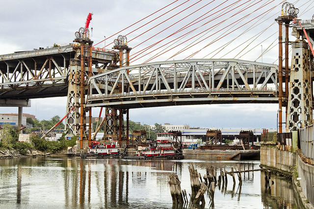
We’re breaking with normal Newtown Pentacle tradition today, and there will be multiple posts coming your way, devoted to the seismic events on Newtown Creek which saw the central truss of the Kosciuszko Bridge first lowered and then carted away over the last couple of days. This second post carries some proper shots of the lowering action. In this morning’s post, a time lapse video of the lowering of the Kosciuszcko Bridge’s central truss was offered. What follows will be everything else I shot, basically all the stills.
There’s a third post that’ll be coming your way tonight, btw., so keep an eye on this – your Newtown Pentacle.

– photo by Mitch Waxman
One had arrived at the Meeker Avenue street end, aka Penny Bridge, by about ten in the morning. Not too much was happening, and word reached me that the lowering process – originally scheduled to begin at ten, would be delayed several hours due to an engineering issue which needed to be solved.

– photo by Mitch Waxman
There were several tugs buzzing about.

– photo by Mitch Waxman
Above, you can see the two flat top barges which were married together by a steel superstructure which would accept and support the bridge section.

– photo by Mitch Waxman
The truss itself was no longer supported, structurally speaking, by the approaches or towers which had cradled it for the last seventy eight years. Instead, it was the four “strand jacks” which were holding it up. Those yellow bits were the shoes on which the truss’s girders sat.

– photo by Mitch Waxman
FDNY and NYPD harbor units were on scene, with different units arriving and departing all day.

– photo by Mitch Waxman
The barges were continuously maneuvered, throughout the day.

– photo by Mitch Waxman
About two in the afternoon, the truss began to lower. It was moving so slowly, about twenty feet per hour I’m told, that to the eye it appeared entirely static.
– photo by Mitch Waxman
I was using two cameras, if you’re wondering. One was on a tripod, the other handheld.

– photo by Mitch Waxman
As the burning thermonuclear eye of God itself dipped behind Manhattan, and the Newtown Creek grew dark, the crews were still lowering the truss. The garish lights of the new bridge activated.

– photo by Mitch Waxman
There was quite a crowd gathered all around the Newtown Creek, and especially so at the Penny Bridge site where I was.

– photo by Mitch Waxman
By about 9:30 or so, the truss was almost resting on the barge.

– photo by Mitch Waxman
A groaning sound of buckling steel echoed out across the Creek as the weight of the truss was suddenly taken up by the superstructure on the barges.

– photo by Mitch Waxman
One spent about twelve hours at Penny Bridge, or the Meeker Avenue Street End, on the 25th of July in 2017. I would have to come back to Newtown Creek the next day, of course, to get shots of the thing leaving. That’s tonight’s post, however, as I’m still finishing up the shots for that one as you’re reading this.
Documenting this project has been a long standing project of mine – this 2012 post tells you everything you could want to know about Robert Moses, Fiorella LaGuardia, and the origins of the 1939 model Kosciuszko Bridge. Just before construction started, I swept through both the Brooklyn and Queens sides of Newtown Creek in the area I call “DUKBO” – Down Under the Kosciuszko Bridge Onramp. Here’s a 2014 post, and another, showing what things used to look like on the Brooklyn side, and one dating back to 2010, and from 2012 discussing the Queens side – this. Construction started, and this 2014 post offers a look at things. There’s shots from the water of Newtown Creek, in this June 2015 post, and in this September 2015 post, which shows the bridge support towers rising. Additionally, this post from March of 2016 detailed the action on the Queens side. Most recently, here’s one from May of 2016, and one from June of the same year. Here’s one from August of 2016, the December 2016 one, one from March of 2017 which discusses the demolition of the 1939 bridge.
Most recently – a post showing what I saw during a pre opening walk through in early April of 2017, and the fanfare surrounding the opening of half of the new bridge in April of 2017, and a walk through of the Brooklyn side job site in June of 2017. Lastly, here’s some night shots from early July of 2017.
Upcoming Tours and events
The Insalubrious Valley of the Newtown Creek Walking Tour, with Newtown Creek Alliance – Saturday August 5th, 11 a.m. – 1;30 p.m.
Century old movable bridges, the remains of a 19th century highway between Brooklyn and Queens, and explore two of the lesser known tributaries of the troubled Newtown Creek watershed. For the vulgarly curious, Conrad Wissell’s Dead Animal and Night Soil wharf will be seen and described, with NCA Historian Mitch Waxman – details here.
Brooklyn Waterfront Boat Tour, with Working Harbor Committee – Saturday August 12th, 6 p.m. – 8 p.m.
Explore the coastline of Brooklyn from Newtown Creek to Sunset Park, with NCA Historian Mitch Waxman, Andrew Gustafson of Turnstile Tours, and Gordon Cooper of Working Harbor Committee on the narrating about Brooklyn’s industrial past and rapidly changing present. – details here.
The Poison Cauldron of the Newtown Creek Walking Tour, with Newtown Creek Alliance – Sunday August 13th, 11 a.m. – 1:30 p.m.
Explore the hellish waste transfer and petroleum districts of North Brooklyn on this daring walk towards the doomed Kosciuszko Bridge, with NCA Historian Mitch Waxman – details here.
Two Newtown Creek Boat Tours, with Newtown Creek Alliance and Open House NY – Wednesday August 16th, 5 p.m. and 7 p.m.
The neighborhoods surrounding Newtown Creek are home to the densest collection of these garbage facilities anywhere in the city and collectively, the waste transfer stations around and along Newtown Creek handle almost 40% of the waste that moves through New York. Join Newtown Creek Alliance’s Mitch Waxman and Willis Elkins to learn about the ongoing efforts to address the environmental burden that this “clustering” has caused. – details here.
“follow” me on Twitter- @newtownpentacle


