Posts Tagged ‘photowalk’
That’s some set of stairs, I tell’s you
Thursday

– photo by Mitch Waxman
The destination which I had in mind when leaving HQ is pictured above. It’s one set of the many, many municipal staircases which climb up and down the hills and valleys of Pittsburgh. This one, in particular, is branded with Duquesne University logos and there’s an overpass which allows pedestrians to cross a high speed road called the Boulevard of the Allies nearby the Monongahela River.
It’s something, I tell’s ya.

The Panorama image above, which breaks into the usual format here at Newtown Pentacle, gives an idea of the streetscape by which you approach the stairs. If you click, it’ll open up a version of the image at Flickr which you can zoom in on.

– photo by Mitch Waxman
These stairs are actually not that difficult to negotiate, but vertigo is a definite factor so I held tightly onto the bannister with my non camera holding hand. Down below, there’s a couple of highways which fly about on elevated ramps. A local street, Forbes Avenue, feeds into what I’m fairly sure is the Penn Lincoln Highway section of I-376, and there’s also U.S. Highway 22 in the mix. Beneath all of those ramps are the Armstrong Tunnels, and a local street called Second Avenue as well as the on and off ramps of a bridge.
Additionally, a ‘rail to trail’ bike and pedestrian path is mixed into the arrangement – a section of the Great Allegheny Passage called the Eliza Furnace Trail, which I had walked a few months ago, and on this day I was heading – ultimately – to the same spot I was back then – the South Tenth Street Bridge.

This Panorama is from the top of the stairs, looking eastwards along the Monongahela River towards the south side of Pittsburgh and the Birmingham Bridge.

– photo by Mitch Waxman
Massing shapes, that’s what I call them. The building at the top right of the shot is the City’s jailhouse, and a brand new homeless shelter has recently opened right next door to it. I don’t think the symbolism is lost on anyone, including the poor devils who reside in one or the other.
That’s also just short of where the Boulevard of the Allies returns to ground and becomes a ‘normal’ street again, with traffic lights and crosswalks. In a post that’ll likely be coming your way sometime in the next couple of weeks, I’ll show you what that looks like, and describe what it’s like to use the pedestrian and bike lane leading to the Liberty Bridge, so get ready lords and ladies. Thrills and chills.

– photo by Mitch Waxman
My next goal post was to get to the South Tenth Street Bridge, pictured above, and use that crossing over the Monongahela to situate myself properly to catch the T light rail back to HQ. Remember, I had left the Mobile Oppression Platform parked in my driveway, and used the T to get to the center of things in Pittsburgh – where I had a moment of Epiphany and then passed by St. Benedict the Moor, and admired the old timey vibe encountered on the Bluff.
Seriously though, height and I are old friends, but a humble narrator will admit to having what has always described as being a very deep and quite logical respect for heights. Others might describe it as phobic.

– photo by Mitch Waxman
The rickety wooden steps didn’t bother me one bit. The concrete planks which formed the ‘run’ of the middle section were badly seated and you felt a distinct shift and clicking sound when in that section. At the very top, the stairs are made from a kind of metal grate, which allows you to look down through them. Forgive my french, but that was ‘effed up.
I’ve always gotten a certain physical sensation, specifically tingling in the fingertips and a feeling of numbness in the palms, when I’m situated at a high spot. I’ve found myself on the roof of a surprising number of skyscrapers in Manhattan, and seem to have spent the last fifteen years walking across bridges so it’s not like it slows me down or anything. I don’t lock up as some do, but I become extremely deliberate and restrained while moving in high environments, a postural affectation which contrasts with the norm.
A friend of mine once described my locomotive style as ‘herkie jerkie, like a spasmodic flying jew.’ I’ve also been told that I always look angry, and that my ‘scuttling with a purpose’ posture imparts the impression that I’m on my way to murder someone or something.
Truth be told… both POV’s in this YouTube video clip link are pretty much how the world looks and feels to me, most days.

– photo by Mitch Waxman
Just so you don’t think I’m making a mountain out of a molehill, nor ‘that I’ve seen too many movies,’ or any of the other crap I’ve heard over the years – the top right brick building is part of Duquesne University. Follow that to the black structure on top of the cliff. That’s photo and panorama one. There’s power lines and a lamp post in shot two, and if you follow those power lines down to where that white van is on the extreme lower left side of the shot above, that’s the bottom of the stairs. Whew.
Holy Pittsburgh!
“follow” me on Twitter- @newtownpentacle
Buy a book!
“In the Shadows at Newtown Creek,” an 88 page softcover 8.5×11 magazine format photo book by Mitch Waxman, is now on sale at blurb.com for $30.
Uptown, or the Bluff?
Wednesday

– photo by Mitch Waxman
My ignorance regarding the new habitat is admitted, but often feels suffocating. This is coming from the guy who used to conduct walking tours in NYC and would proudly stand on the county line delineating the currently undefended border of Queens and Brooklyn and say ‘welcome to…’
I have no idea where the lines are found which form the borders between Pittsburgh’s various zones and neighborhoods, nor which areas are war zones. More than once, I’ve described where I had been that day to some bartender or new neighbor that are local to Pittsburgh and they’ll say “you went where? Stay out of there, they’ll shoot you dead, that’s…”
If I had a dollar for every time I’ve been told that over the years… at any rate, the area I was moving through in the case of today’s missive abuts Duquesne University, so I felt pretty ok about scuttling through – personal security wise. Duquesne is a Roman Catholic college which is perched on a particularly dramatic chunk of land that overlooks the Monongahela River, and is located a bit eastwards of the peninsular landform that ultimately becomes Pittsburgh’s Golden Triangle.

– photo by Mitch Waxman
The rough path I had laid out for myself the night before indicated that I’d need to cut across Duquesne’s campus to get where I was going. Luckily, the streets that flow through the campus are public ones and it was ok for me to do so. There’s a lot of ‘old’ buildings nearby Duquesne, clearly left overs of the mercantile and industrial eras. The building stock looks a lot like the sort of thing you’d encounter in Lower Manhattan on the west side of Canal Street.
Nature called, but unlike Manhattan, you don’t need to pee in the street like a dog in Pittsburgh. I stopped off at a restaurant and asked if I could use the bathroom. The kid at the counter looked at me like I was crazy and said ‘sure, it’s right there sir.’ On my way back out I dropped a few coins in the tips jar and said thanks.
Imagine that… you can find a bathroom when you need to.

– photo by Mitch Waxman
The ground began to angle upwards as I headed towards the campus’ street grid. I kept on thinking about how my old pal Kevin Walsh from Forgotten-NY would be in absolute heaven wandering about this area with its stock of centuried buildings.
I was heading straight up the hill towards the titular edge of the landform, however, and didn’t have time for the ‘used to be, once, long ago’ thought process. Back tomorrow with where I was going and what I saw when I got there, at this – your Newtown Pentacle.
Also, if this post strikes your fancy, please consider hitting ‘Like,’ maybe ‘subscribe,’ and ‘share’ as that sort of thing really helps me out.
“follow” me on Twitter- @newtownpentacle
Buy a book!
“In the Shadows at Newtown Creek,” an 88 page softcover 8.5×11 magazine format photo book by Mitch Waxman, is now on sale at blurb.com for $30.
Investigating the GAP, part two
Thursday
– photo by Mitch Waxman
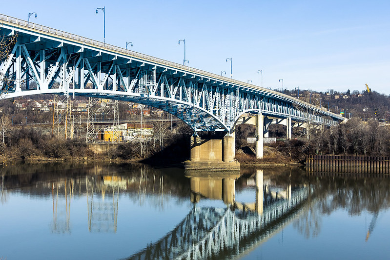
As described yesterday, one parked the Mobile Oppression Platform at the Homestead Pump House’s parking lot and began a longish walk on the Great Allegheny Passage “rail-to-trail” pathway. Rail to trail is one of the options for what to do with the right of way of a railroad line which is no longer active. In the case of the GAP, the rail bed has seen the ties and actual rails removed and the ground either paved or covered with crushed limestone. It’s an easy walk, due to the grading that the rail engineers employed when laying out these right of ways (ROW), which is essentially a change of one foot in elevation for every hundred feet horizontally. The GAP trail in the Pittsburgh area which I was on starts in Homestead and doesn’t re-emerge onto the streets until you reach the community of Duquesne, which is many miles away.
I had a destination and “turn around point” in mind, for this scouting mission, which was more or less equidistant between Homestead and Duquesne. This trail was thereby fairly easy walking, and there was lots to see along the Monongahela River, which the GAP trail follows.

– photo by Mitch Waxman
Back in NYC, I’d often be asked where I’d want to go if time travel were possible. My response is usually “if you stepped out of your time machine into the late 19th century NYC, you’d have a knife slid into you within about 15 minutes.” Here in Pittsburgh, other than dodging freight trains hauling coal and coke at breakneck speeds, you’d have a different time travel problem – breathing. There are still operating steel plants here, but their emissions are a fraction of what would have once been found along the Monongahela Valley. I should mention that the emissions are an ongoing problem, however, and that the U.S. Steel people are often fined for violations of the Clean Air Act.
Mark Twain’s quote about Pittsburgh in 1884 reads “After our show, last night, we visited Mount Washington and took a bird’s eye view of your city by moonlight. With the moon soft and mellow floating in the heavens we sauntered about the mount, and looked down on the lake of fire and flame. It looked like a miniature hell with the lid off. It was a vision. A wonderful vision. It tended to frighten. The view is not as deliciously beautiful as one would suppose. If one can be calm and resolute, he can look upon the picture and still live. Otherwise, your city is a beauty.”
– photo by Mitch Waxman
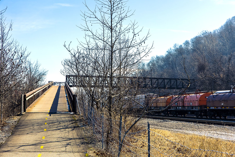
About a mile or so onto the trail, an overpass bridge is encountered, one which I’m told was added to the equation when the GAP trail was created. It allows transit over the active freight tracks the GAP follows from Homestead, and on the other side of the thing the trail continues along on an earthen shelf set in along a steep slope.
This bridge was one of the things which drew me in, what a great place to observe and photograph trains from, huh?

– photo by Mitch Waxman
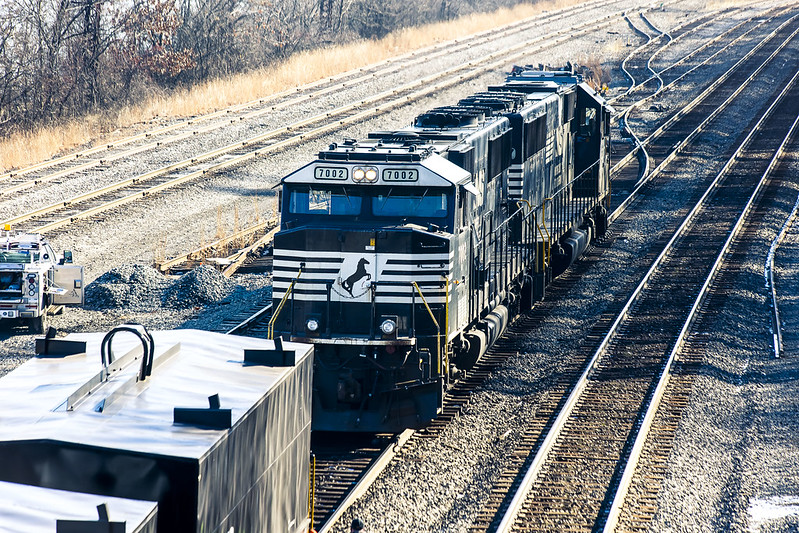
Norfolk Southern, like CSX, emerged as a dominant player in American Rail after the Conrail years and was formed out of several smaller operations. Their rolling stock heraldry is black and white, with a horse rearing up in silhouette acting as their logo. They’re pretty active in this region, and others.
There was a train set just sitting and waiting for its engine to show up, which luckily enough happened just as I surmounted the overpass bridge. A couple of workers were flipping the track switches around, and the engine was moving into position to couple with the train set.
– photo by Mitch Waxman
One could have stood on that overpass all day, photographing the comings and goings of the rail people. I probably will when the weather is warmer and I’ve packed a lunch. For this scouting mission, however, I still had a fairly decent amount of walking to do before I got to what I was actually seeking.
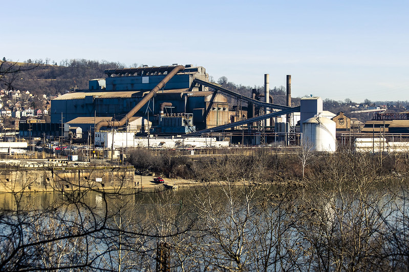
I haven’t been the same since visiting Braddock and seeing the Mon Valley Works steel plant. A need not unlike hunger demanded that I photograph it, which was a difficult thing to do from the landward side in Braddock. I wanted the river in the shot, as well. The GAP is the first location I’ve found so far that allows for this.
– photo by Mitch Waxman
I generally scuttle along at a comfortable pace, covering about two and change miles in an hour. Two hours into this walk, I finally arrived where I wanted to be. I had to find spots where the tree line wasn’t occluding my view of the U.S. Steel Mon Valley Works, but that did it take me long.
Tomorrow, the sort of shots I was looking for.
“follow” me on Twitter- @newtownpentacle
Buy a book!
“In the Shadows at Newtown Creek,” an 88 page softcover 8.5×11 magazine format photo book by Mitch Waxman, is now on sale at blurb.com for $30.
Investigating the GAP, part one
Wednesday
– photo by Mitch Waxman
Last week, I showed you what the historic Homestead Pump House site on the Monongahela River looked like when bathed in thick fog. Lament was offered regarding the lack of a freight train transiting over the Pinkerton’s Landing or “Pemickey” Rail Bridge.
The Homestead Pump House is one of the trail heads for The Great Allegheny Passage or “GAP” rail to trail system. 150 miles in length, the rail to trail pathway follows several incorporated rights of way once operated by the B&O Railroad, Lake Erie Railroad, Union Railroad, and the Western Maryland Railway. You could theoretically walk or ride a bike to Washington D.C. on this path, which is paved in asphalt or crushed limestone – depending on where you are – and graded in accordance with the rail standard of one foot of elevation for every hundred feet.
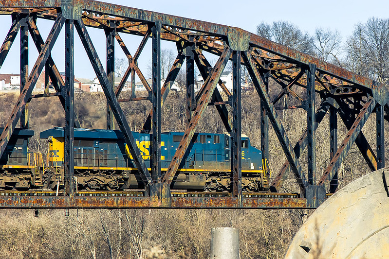
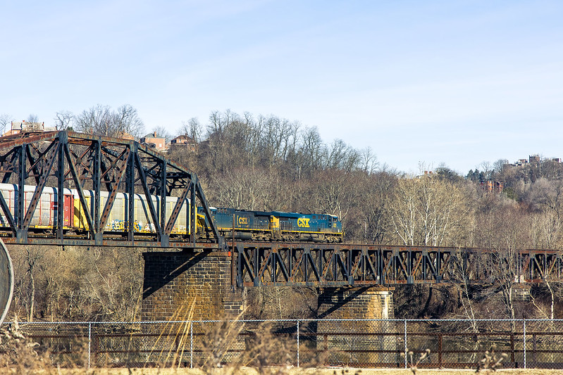
Pictured above, this time around my dreams of a train moving over the bridge came true as a CSX freight train appeared and I was able to get a few shots of its transit across the rail bridge.
– photo by Mitch Waxman
The Homestead site has a parking lot, one which leads to the actual trail after a short walk on a sidewalk. I did all the remote scouting that was warranted, using Google maps and a few other tools as well as watching a YouTube video offered by some bloke who rode the trail on a bike. One still hasn’t purchased a shuttle craft bike which will accompany me in the cargo area of the Mobile Oppression Platform (that’s the nickname I’ve assigned to my Toyota), and be deployed for hyper local transport.
I don’t really keep track of how many miles I walk. Sometimes, after a walk I’ll check my phone to see how many steps it perceived me as taking on an excursion. If there’s any accuracy to that data, I walked on the trail about 4 miles in and 4 miles back. It was an extremely easy walk, thanks to the pavement and the easy grading in elevation. There were even installed park benches for taking a break along the route, but one of my rules involves not sitting down when you’re out. Keep moving until you’re back where you started.
– photo by Mitch Waxman
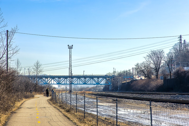
Active rail tracks are visible for the entire section of the GAP I visited. Defunct gas and rail infrastructure was noticed on the water facing shoreline for a good chunk of this distance, and there was a high volume road at the top of a shallow ridge overlooking the whole shebang. The municipality of Homestead was where I entered the trail, and there were markers here and there letting you know what town you were walking through.
That’s how I learned there’s a place called Munhall in Pennsylvania, those signs. There were actually a fair number of people using the trail for running and bike riding for a weekday afternoon in January. A good proportion of the bike riders were wearing the “outfit” – the helmet with the rear view mirror on it and a polyester bike shirt, stretchy shorts, and those special bicycle shoes. Like I said – the outfit. Most of the bikes were road racers, but I spotted a couple of pedal assist electric ones too.
– photo by Mitch Waxman
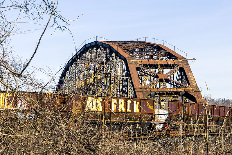
That’s the Carrie Furnace Hot Metal Bridge pictured above, I believe. Before you ask – of course I looked, and yes you can, and no it’s probably not ok but there doesn’t seem to be anybody watching, so of course, but no, not this time around. Next time, maybe.
I continued along the GAP trail, scuttling along at a leisurely pace.
– photo by Mitch Waxman
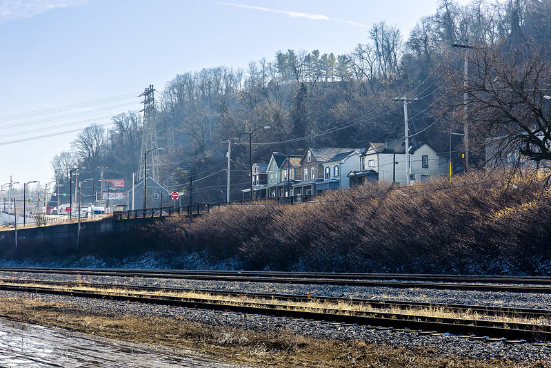
Once you’re a fair bit into the GAP trail, you’re completely separated from the surrounding town and of course – there’s no automobile traffic zipping along at high speeds to worry about.
On a personal note – it’s been a very long time since I’ve had the time to take a very long walk like this one. It felt very good to stretch the legs, kick the heels, and point the toes. Ultimately, this was another scouting expedition. It was mid afternoon, and the light was a ghastly thing to handle. For the ultimate destination I had in mind, this scouting revealed it as an early morning or sunset sort of deal. It’s also a winter thing, as the foliage must obscure all of the cool stuff you can see from this path during the warmer months when the trees are clad.

– photo by Mitch Waxman
The GAP follows under the Rankin Bridge spanning the Monongahela River. The 1951 bridge has a fairly convoluted history, and it once was used to carry Trolley traffic as well as motor vehicular flow, apparently. There’s a few very nice points of view in this section of the trail that I’m going to return to in the future. For this trip, my main interest was in getting close to the Mon Valley works, and I still had a few miles to walk to get there.
More tomorrow, from the GAP.
“follow” me on Twitter- @newtownpentacle
Buy a book!
“In the Shadows at Newtown Creek,” an 88 page softcover 8.5×11 magazine format photo book by Mitch Waxman, is now on sale at blurb.com for $30.
an Allegheny interval
Tuesday

– photo by Mitch Waxman
One had a couple of hours to kill recently, and decided to do a proper photowalk on the north side of downtown Pittsburgh. This area which I was in, I’m told, was an independent municipality in Allegheny County called Allegheny City until 1907, when it was annexed by another municipality. Pictured above is Downtown Pittsburgh, which is the neighboring city that did the annexation.
The waterfront in this area is part of the Three Rivers Heritage Trail, which is a post industrial accommodation open to the public for exercise and recreation. Lots of joggers and bicyclists are moving about, and right behind me while I was shooting these there was some kid trying to figure out to ride his skateboard. This is right about where the Allegheny River feeds into the Ohio River.

– photo by Mitch Waxman
Looking along the Allegheny River, past the Fort Duquesne steel bowstring bridge and towards the “three sisters” suspension bridges. Last week, frequent commenter and wise aleck George the Atheist asked in a comment why there are so many different types of bridges here in Pittsburgh. I don’t have a definitive answer but I’ve got a few theories. First is that these bridges were largely installed over a 75-100 year period and that technologies and materials change over time. The second, and this one fits in with my somewhat conspiratorial point of view, is that Pittsburgh was the home of the American Bridge Company.
My theory is that American Bridge Company, as organized by JP Morgan, used Pittsburgh’s waterfront as a showroom for its national and international customers. Notably, American Bridge Company was one of the principal contractors used for most of NYC’s “lesser” bridges including the Pulaski Bridge spanning my beloved Newtown Creek. They also worked, and still work, on the major bridges too.

– photo by Mitch Waxman
One decided to shed the tripod and filter setup, and just shoot shots instead for the remaining time I’d be out. Scouting, that’s what I’m doing. What I want to be doing is shooting long exposure and loving photographs of Pittsburgh and its wonders, but it kind of bogs me down and keeps me from discovering new things and points of view. I still need to wander about and find these points of view before I get fancy… that’s what my inner narrative naggingly reminds.
I packed up the gear, and set my heels a clicking for a proper photowalk, thereby. I followed the Three Rivers Heritage trail, heading off along one of the Ohio River legs of the path.

– photo by Mitch Waxman
That’s the West End Bridge, which I showed you from above last week. Pittsburgh has been dealing with an explosion of unhoused folks camping out in tents and makeshift dwellings along the waterfront in recent years. Political outrage about this has caused the City to send in the cops and sanitation crews to clear out the dwellings and to try and convince the unhoused folks to literally come in from the cold and take a bed at a homeless shelter. This went about as well as it does in any American City, as the section of the trails in the Downtown area which the TV News people filmed the Government types “cleaning up” remains depopulated, but the zones which didn’t receive the media attention still host people living in dire circumstance. The Ohio River frontage is one of those zones.
I should mention that use of the word “explosion” in the Pittsburgh context indicates that there were a couple of hundred down on their luck street and or traveling people living rough in tents and make shift huts – at most. This made the TV news, in heavy rotation.

– photo by Mitch Waxman
I approached the great cathedral and spiritual center of Pittsburgh, and the most important thing in this region of the country. This structure, which occupies the thoughts, prayers, and minds of all Pittsburgh and its surrounding counties is a sports ball arena that is home to the Steelers football team. Formerly called Heinz Field, naming rights for the stadium were recently acquired by an outfit called Acrisure. Across the street from the stadium is the Carnegie Science Center, an interactive museum largely designed for kids. In between the two is a parking lot which costs $6 for all day parking, and it’s where I left the Mobile Oppression Platform while I was out walking around and shooting.
It was starting to get dark, and since I don’t know the “lay of the land” quite yet, I decided that I would be happier and quite a bit safer in the car. It’s not that things are dangerous hereabouts, but I’m ignorant of what a good neighborhood versus a bad one looks like. Additionally, there was a nearby industrial zone I wanted to take a look at which was definitively “car country” rather than being pedestrian friendly.

– photo by Mitch Waxman
One of those industrial zone spots which I wanted to take a look at involved the Western State Penitentiary, a now shuttered prison found in the former Allegheny City and along the Ohio River. Word has it that opportunity to visit and photograph parts of this facility might materialize during the spring or summer, notably as part of a citywide event called Doors Open Pittsburgh. Doors Open’s operation is reminiscent to me of Open House NY, whom I worked with for several years on walking and boat tours of Newtown Creek.
More tomorrow, from the Paris of Appalachia, at your Newtown Pentacle.
“follow” me on Twitter- @newtownpentacle
Buy a book!
“In the Shadows at Newtown Creek,” an 88 page softcover 8.5×11 magazine format photo book by Mitch Waxman, is now on sale at blurb.com for $30.


