Posts Tagged ‘photowalk’
dimly lit and illimitable corridors

– photo by Mitch Waxman
Over in the part of Long Island City that isn’t shiny, where it stinks of work and sweat and oil and shit and every surface is painted with an iridescent sheen – the colour- scuttled your unworthy narrator. Perambulation through the apocalyptic wastelands of a post industrial Long Island City is no picnic during the urban season defined by “wind chills”, I assure you. This location will be familiar to longtime readers, this is 51st ave. and what would be 21st street, across the street from the Blanchard Building.
This little pedestrian bridge- officially known as the 51st avenue Bridge, is meant to be replaced fairly soon, according to the City.
from queenscourier.com
“The existing bridge there will be demolished. The new one will be realigned over the tracks and will have brand new ramps,” said Craig Chin of DDC. Chin confirmed that after final design approval has been received by the New York City Design Commission bidding will start for the project in spring 2010, with a possible completion by winter 2010.
At first glance the 51st Avenue bridge appears not to be in such bad shape. However, a DOT spokesperson said that in an internal rating system, that includes many structural elements that might not be visible to a pedestrian or are only visible from the topside, determined that this bridge at 51st Street was a replacement priority.

– photo by Mitch Waxman
This is the only pedestrian connection between the shiny new Long Island City, Tower Town, and the grimy industrial engine which it is being built on top of. Personal observation reveals that the people who use this bridge are laborers moving back and forth from mass transit centers along Jackson Avenue and the Great Machine at Queens Plaza. Underserved as the area is by mass transit, the city nevertheless anticipates an enormous surge in pedestrian and vehicle traffic once a catastrophically bad idea called Hunters Point South is completed.
from nyc.gov
More than 5,000 new apartments are anticipated to be constructed in the primary neighborhood character study area by 2017, including completion of the residential development at Queens West and many other mid-size residential buildings throughout the immediate area. Almost 11,000 new residents are expected in the primary study area as a result of this new construction activity.
As the primary study area (and the secondary study area, discussed below) becomes more densely developed, traffic and pedestrian volumes will increase noticeably from the current levels. Intersections throughout the area will be more congested in the morning, midday, and evening peak hours. The intersections that currently experience some congestion on Vernon Boulevard will be noticeably more congested, with some levels of service D and even LOS F, indicating high to unacceptable delays. In addition, other intersections along Vernon Boulevard in the primary study area will also have moderate to high congestion in the peak hours. On the east-west avenues in the area near the project sites (i.e., 48th, 49th, 50th, and 51st Avenues) traffic volumes are expected to increase slightly.
Pedestrian volumes will also increase in the future without the proposed actions, but sidewalks, corners, and crosswalks will generally continue to operate at acceptable levels. The crosswalk across Vernon Boulevard on the north side of 50th Avenue will, however, become noticeably congested during the morning peak hour, as people cross to enter the subway station there. This crosswalk will operate at LOS E, as will the subway stair closest to the corner (Stair S8). Buses serving the primary study area will also be noticeably more crowded.

– photo by Mitch Waxman
Borden Avenue is the main attraction hereabouts, a loathsome stretch of fortress walled warehouses which passes by the Queens Midtown Tunnel, the LIRR tracks, the Pulaski Bridge– and all the while following the bulkheaded course of a certain body of water. The Newtown Creek is one block away, but you knew that by the smell already. Lately, my headphones have been playing music again, rather than the podcasts and audiobooks normally presented- but even the Dropkick Murphys can’t drown out the sound. There’s an app for that, as the ad slogan goes, and one I like is called “Decibel Meter“.
Here, under the LIE and again- a couple of thousand feet from the Queens Midtown Tunnel and over a rail yard and near the Pulaski- its rough metering reported a sound level 106 db (which is the limit of the iphone microphone). The iphone is hardly a scientific instrument, of course, but all the union guys I see working around here are wearing ear plugs. The non union guys aren’t.
from wikipedia
Louder sounds cause damage in a shorter period of time. Estimation of a “safe” duration of exposure is possible using an exchange rate of 3 dB. As 3 dB represents a doubling of intensity of sound, duration of exposure must be cut in half to maintain the same energy dose. For example, the “safe” daily exposure amount at 85 dB A, known as an exposure action value, is 8 hours, while the “safe” exposure at 91 dB(A) is only 2 hours (National Institute for Occupational Safety and Health, 1998). Note that for some people, sound may be damaging at even lower levels than 85 dB A. Exposures to other ototoxins (such as pesticides, some medications including chemotherapy, solvents, etc.) can lead to greater susceptibility to noise damage, as well as causing their own damage. This is called a synergistic interaction.
Some American health and safety agencies (such as OSHA-Occupational Safety and Health Administration and MSHA-Mine Safety and Health Administration), use an exchange rate of 5 dB. While this exchange rate is simpler to use, it drastically underestimates the damage caused by very loud noise. For example, at 115 dB, a 3 dB exchange rate would limit exposure to about half a minute; the 5 dB exchange rate allows 15 minutes.
While OSHA, MSHA, and FRA provide guidelines to limit noise exposure on the job, there is essentially no regulation or enforcement of sound output for recreational sources and environments, such as sports arenas, musical venues, bars, etc. This lack of regulation resulted from the defunding of ONAC, the EPA’s Office of Noise Abatement and Control, in the early 1980s. ONAC was established in 1972 by the Noise Control Act and charged with working to assess and reduce environmental noise. Although the Office still exists, it has not been assigned new funding.

– photo by Mitch Waxman
The afternoon sun is always a pleasure around this little truss bridge, the 21st street truss as Forgotten-NY once called it. It lights the smoggy miasmas, produced by the fuming exhaust of the thousands of vehicles passing overhead as they mix with those unstudied emissions wafting from the Newtown Creek. The same vapors that tattoo the “colour” and dissolve the marbles and bronze of Calvary, a corrosive ether that smells of petrochemical filth and reminds one of rotting pork, hatch up through the loathsome mud found all along the Creek.
from epa.gov
Newtown Creek is a part of the New York – New Jersey Harbor Estuary that forms the northernmost border between the New York City boroughs of Brooklyn and Queens. In the mid 1800s, the area adjacent to the 3.8 mile Newtown Creek was one of the busiest hubs of industrial activity in New York City. More than 50 refineries were located along its banks, including oil refineries, petrochemical plants, fertilizer and glue factories, sawmills, and lumber and coal yards. The creek was crowded with commercial vessels, including large boats bringing in raw materials and fuel and taking out oil, chemicals and metals. In addition to the industrial pollution that resulted from all of this activity, the city began dumping raw sewage directly into the water in 1856. During World War II, the creek was one of the busiest ports in the nation. Currently, factories and facilities still operate along the creek. Various contaminated sites along the creek have contributed to the contamination at Newtown Creek. Today, as a result of its industrial history, including countless spills, Newtown Creek is one of the nation’s most polluted waterways.
Various sediment and surface water samples have been taken along the creek. Pesticides, metals, PCBs, and volatile organic compounds (VOCs), which are potentially harmful contaminants that can easily evaporate into the air, have been detected at the creek.

– photo by Mitch Waxman
On the other side of the street from this sign is the Queens Midtown Tunnel, with its signage prominently decrying photography or video operation. Loose lips sink ships and all that, and the front line people “in the know” seem to believe this area to be a prominent target for the Terror Warriors, so we’ll just agree that its there and not show it. Despite the fact that its going to be sitting at the very center of a residential neighborhood by 2020 and the fact that you can park a vehicle here.
from mta.info
1020.8 Compliance with posted signs. Every motorist and pedestrian using any facility under the jurisdiction and control of the Triborough Bridge and Tunnel Authority shall obey and comply with the provisions of any posted sign on any of its facilities.

– photo by Mitch Waxman
The scion of this residential neighborhood is L Haus, a newly completed building whose non facing side is similarly on 50th avenue, roughly one and a half city blocks from where we started on 51st avenue.
from curbed.com
Long Island City’s “Mystery Building,” a condo sitting at the foot of the Pulaski Bridge and sort of functioning as the neighborhoods greeter for people driving over from Brooklyn has been outed. The neighborhood blog LIQCity identifies it today as “The L Haus,” named after its shape and, you know, “house” in German. (It’s the big, green boxy thing in the photo.) Other relevant details/rumors: the offering plan is “about to hit the street” and Elliman will be bringing it to market at prices in the $600-$700 per square foot range.
Esoteric Trains at Corona Yard
– photo by Mitch Waxman
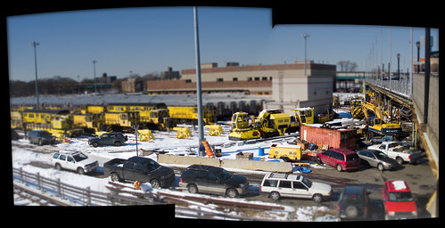
Leaving the broad shoulders of Astoria for a days hike, your humble narrator found himself at the Corona Yard staring over a fence at some of the MTA’s less familiar kit. This is where the 7 train sleeps, and also where one can observe an assortment of “work trains”. Said “work trains” are specialists, non passenger, and rarely seen or commented on by the public. While crossing the pedestrian ramp from Roosevelt Avenue to Flushing Meadow Corona Park, I was on the lookout for the “snow train”, but that wasn’t what I found.
from nydailynews.com
“It’s like your household snow blower but a million times bigger,” agency engineer Edward Macina said late Wednesday as the five-car diesel train chugged past the silent expanse of Kennedy Airport.
The train is a key component in the agency’s comprehensive snow-battle plan.
A six-foot cylindrical brush attached to the front sweeps snow into an even wider metal tube.
Snow is then blasted away — far away — from the rails from the mouth of a chute about eight feet in the air.
The machine can launch the snow 200 feet, removing 3,000 tons of snow an hour. Macina, project manager in the car equipment department, joked ‘Snow Eater’ might be an appropriate nickname.

R125 Ballast Regulator – photo by Mitch Waxman
Corona Yard is a rail fan’s dream. Active rolling stock sits quietly in the sunlight next to a historical catalog of the MTA’s former workhorses and modern utility trains.
from wikipedia
Corona Yard is the yard facility in Flushing, in the New York City borough of Queens, that serves the IRT Flushing Line (7) of the New York City Subway. It is located in Flushing Meadows-Corona Park, near Citi Field, the National Tennis Center, and the site of the 1939 and 1964 World’s Fairs.
Corona Yard opened in 1928 and has seen various models of cars, including Steinway Low-Vs, Brooklyn-Manhattan Transit Corporation/BMT Qs, R12s, R14s, R15s, World’s Fair R36s in 1964, and R62As. It also contains the Casey Stengel Bus Depot.
On August 16, 2006, the original 1928 shop building was demolished, and was replaced by a new, modern shop.

Ballast Tamper TP239 – photo by Mitch Waxman
This mechanism, for instance is a “Ballast Tamper”, which is a track maintenance and repair unit.
from wikipedia
A ballast tamper or tamping machine is a machine used to pack (or tamp) the track ballast under railway tracks to make the tracks more durable. Prior to the introduction of mechanical tampers, this task was done by manual labour with the help of beaters. As well as being faster, more accurate, more efficient and less labour-intensive, tamping machines are essential for the use of concrete sleepers since they are too heavy (usually over 250 kg) to be packed into the ballast by hand.
Early machines only lifted the track and packed the ballast. More modern machines, sometimes known as a tamper-liner or tamping and lining machine, also correct the alignment of the rails to make them parallel and level, in order to achieve a more comfortable ride for passengers and freight and to reduce the mechanical strain applied to the rails by passing trains.

– photo by Mitch Waxman
Hey, those are “Redbirds” back there, weren’t they all supposed to be coral reefs by now?
from wikipedia
Redbird is the name given to 1,408 New York City Subway cars of the following types: R26, R28, R29, R33 ML, R33 WF, R36, and R36 WF. These cars were painted a deep red to combat graffiti, which had become a major problem In the late 1970s and early 1980s. The deep red color was referred to as Gunn Red in honor of its originator David L. Gunn, who was the head of the New York City Transit Authority during this period. Initially entering service in various colors, these cars received the new paint scheme between 1984 and 1989. Some R17s were also given this paint scheme in 1985/86, but were retired well before the name “Redbird” caught on.

– photo by Mitch Waxman
This long walk from Astoria to Flushing Meadow Corona Park will be explored in the coming days, here at your Newtown Pentacle, in the first postings of this new “Year of the Metal Tiger“.
An amazing factoid turned up in researching this walk is that Roosevelt Avenue (the 5 miles which extend from the Great Machine at Queens Plaza all the way out to Willets Point) was designated a National Millennium Trail in the year 2000. This places Roosevelt Avenue alongside the Appalachian Trail in cultural importance, but somehow I think that’ll be forgotten next time someone wants to build a 40 story tower condo along it. We’ll get into this in some detail in the coming days…
from wikipedia
A ballast regulator is a piece of rail transport maintenance of way equipment used to shape and distribute the gravel track ballast that supports the ties in rail tracks. They are often used in conjunction with ballast tampers when maintaining track.
affordable housing development on Borden Avenue

– photo by Mitch Waxman
Let me state outright, and at the very start of this post- that the individual discussed here surely must be the toughest person in Queens. The indomitable “life will not beat me, no matter what” spirit of setting up housekeeping in this particular locale signals an iron resolve. This is the Borden Avenue Bridge, entering its second year of emergency construction, spanning the malefic waters of the Dutch Kills– a tributary of the Newtown Creek.
from wikipedia
Dutch Kills is a sub-division of the larger neighborhood of Long Island City in the New York City borough of Queens. It was a hamlet, named for its navigable tributary of Newtown Creek, that occupied what today is centrally Queensboro Plaza. Dutch Kills was an important road hub during the American Revolutionary War, and the site of a British Army garrison from 1776 to 1783. The area supported farms during the 19th Century, and finally consolidated in 1870 with the villages of Astoria, Ravenswood, Hunters Point, Middletown, Sunnyside and Bowery Bay to form Long Island City.

– photo by Mitch Waxman
Observation over time, for this shack or shanty had been established in the first weeks of construction some 14 months ago, has revealed this fellow (I’ve only seen one man emerge from it, perhaps there are others- I can’t say) to be a “crow”. As explained in the past, the nascent recycling industries along the Newtown Creek purchase scrap metals by the pound, and a street level economy subsists on castaway steel, iron, and copper items scavenged from the surrounding industrial and residential trash. There is a small army of these metal collectors, whose blackened and soiled garments have garnered the nomen “Crows” to themselves. Some are driven by need or malice to steal, and lamp posts stripped of access doors and internal copper wire are a common sight around the area. Reports from area cemeteries also point to this population for the identity of vandals who remove the white bronze and copper ornamentation from their grounds.
from the DOT website on the history of the Borden Avenue Bridge, which spans Dutch Kills.
Borden Avenue is a two-lane local City street in Queens. Borden Avenue runs east-west extending from Second Street at the East River to Greenpoint Avenue. The Borden Avenue Bridge over Dutch Kills is located just south of the Long Island Expressway between 27th Street and Review Avenue in the Sunnyside section of Queens. Borden Avenue Bridge is a retractile type moveable bridge. The general appearance of the bridge remains the same as when it was first opened in 1908. The bridge structure carries a two-lane two-way vehicular roadway with sidewalks on either side. The roadway width is 10.5m and the sidewalks are 2.0 m. The west approach and east approach roadways, which are wider than the bridge roadway, are 15.3m and 13.0m respectively. The bridge provides a horizontal clearance of 14.9m and a vertical clearance in the closed position of 1.2m at MHW and 2.7m at MLW.
As part of the construction of Borden Avenue in 1868, a wooden bridge was built over Dutch Kills. This bridge was later replaced by an iron swing bridge, which was removed in 1906. The current bridge was opened on March 25, 1908 at a cost of $157,606. The deck’s original design consisted of creosote-treated wood blocks, with two trolley tracks in the roadway. Character-defining features of this bridge include the stucco-clad operator’s house, four pairs of rails, and a rock-faced stone retaining wall. The gable-on-hip roof of the operator’s house retains the original clay tile at the upper part. Although alterations have been made, the bridge is a rare survivor of its type and retains sufficient period integrity to convey its historic design significance.
The bridge will be closed for construction through July 2009. In addition, there will be parking restrictions in the vicinity of the bridge from January through July 2009 at all times from 25th Street to 30th Place between Borden Avenue and Hunter’s Point/49th Avenue and from 50th Avenue to 51st Avenue between 27th Street and 25th Street.

– photo by Mitch Waxman
As mentioned, the Crow who has set up housekeeping here surely must have a strong and robust physical constitution. The Dutch Kills is one of the darkest parts of the story of the Newtown Creek, a stagnant and poison patch of murky water which exhibits open sewers. The smell of the Dutch Kills in summer, reminiscent of an aquatic reptile tank in need of a water change, is best described by using the analogy of a rotting Ham sandwich. These are nearly the head waters of the Dutch Kills- located at the end of the “empty corridor“, quite near its junction with the noisome Newtown Creek, but is hardly the worst part of it. Penetrating further back to Hunters Point Avenue and all the way to its ending at 47th avenue and 29th street, near the Degnon Terminal, one experiences the olfactory ragnarok in full (I’ll be taking us back there in a post or two, by the way).
also from the DOT website:
The New York City Department of Transportation is performing emergency repair work on the Borden Avenue Bridge. Contract work commenced in January 2009.
During the initial phase of construction, additional areas of structural deterioration in the bridge abutment were identified which required an expansion of the original contract scope of work. The expanded scope of work required excavation in areas that were previously expected to remain undisturbed.
During the excavation of one of these areas, a pocket of contaminated soil was identified. The contamination was analyzed by an accredited testing laboratory and classified as “contaminated non-hazardous”. As such, it poses no significant health risk to workers or the surrounding community. However, precautionary measures will be taken and every effort is being made to remove and dispose of the contamination quickly, yet safely, within all New York City and State guidelines. The history and nature of the industrial community surrounding the bridge revealed that one or more of the previous users of the industrial waterway is the source of the contamination.

– photo by Mitch Waxman
On the plus side, however, someone has already “homesteaded” this up and coming area. Urban pioneers such as this Crow were the ones who established Williamsburg and DUMBO as residential centers, with shanty villages in the 1980’s. The views in the neighborhood are fantastic, with panoramic city skylines and the noble Empire State Building looming over Borden Avenue. Also, views of area bridges, like the Queens Midtown Expressway elevated section of the LIE directly overhead are spectacular. That’s why this neighborhood, ripe for residential development, is called DULIE (Down Under the Long Island Expressway) around Newtown Pentacle HQ.
from nydailynews.com
THE REOPENING of a Long Island City bridge that was closed for emergency repairs is now being pushed back because of toxic sludge found in the soil around the structure.
The century-old Borden Ave. Bridge, which handled nearly 16,000 vehicles a day before it was shut down, was abruptly closed on Dec. 31 because of structural problems.

– photo by Mitch Waxman
To the north, a spectacular fire recently erased a century old abandoned factory, and the ongoing saga of the Borden Avenue Bridge reconstruction has already cleared away the strip club on the corner- as well as several other area businesses which have somehow survived in this lonely corner of Queens for decades. Borden Avenue begins in Long Island City near Hunters Point, and is a local viaduct carrying vehicle traffic toward Greenpoint Avenue where a cloverleaf of onramps presents the option to entrance either the BQE or LIE which provide southern egress to Brooklyn, and all points east.
from nytimes.com
“Even though it’s not the prettiest bridge, people find beauty in it,” said Sam Schwartz, a transportation consultant and the president of the city’s Bridge Centennial Commission, a nonprofit group whose mission is to celebrate six New York bridges that are about a century old. He described the bridge’s retractile feature as “very elegant.”
The Borden Avenue Bridge has not displayed its elegance much lately, however. Commercial marine traffic along Dutch Kills is highly diminished; the bridge last opened for a passing vessel in 2005.
The Transportation Department estimated the cost to stabilize the abutment at $14 million, or, if the wall had to be rebuilt, at $37 million.

– photo by Mitch Waxman
The vast majority of the population in this section of Queens- bordering Blissville, Tower Town at Hunters Point, and Laurel Hill- are “just passing through” on the elevated highway some 10 stories above the putrefaction of the Dutch Kills. The blighting effect of the Borden Avenue Bridge reconstruction has had no small effect on area businesses, which are dependent on trade from passing trucks and cars seeking a shortcut from the Midtown Tunnel traffic flowing out of Manhattan nearby the Pulaski Bridge. It has also created a barrier between the Hunters Point neighborhood and the vastness of Queens. Such disruptive traffic flow would have been anathema to the builder of the Bridge, Edward Byrne.
from wikipedia
Edward Byrne began his civil engineering career in 1886 with the New York City Aqueduct Commission on the construction of the Croton Water Supply System. It is of interest that on this project he met Robert Ridgway, who also was destined to become a distinguished engineer and an outstanding civil servant.
From 1889 to the close of 1897, Byrne worked on highways and bridges for the old Department of Public Works of New York City.
On January 1, 1898, he joined the Department of Bridges and began a striking and noteworthy service which ended in November, 1933, with his resignation from the position of Chief Engineer of the Department of Plant and Structures (the successor of the Bridge Department), in order to assume the duties of Chief Engineer of the Triborough Bridge. His thirty-six years of service in the Department of Bridges, and its successor, the Department of Plant and Structures, may be divided into two periods.
1898-1911
During this period, he was in charge of bridge construction and maintenance, supervizing the construction of the Willis Avenue Bridge over the Harlem River, the Vernon Avenue Bridge, the Borden Avenue and Hunters Point Bridges over Dutch Kills, and the old bridge over Flushing River.
A Great Machine

Queensboro Bridge and associated structures- “The Great Machine” – photo by Mitch Waxman
Queensboro, whose steel has cantilevered the flow of traffic to the shining city from the fabled vastness of the Long Island since 1909, is merely the focal point of a polyglot mechanism whose works spread into the east. The backbone of New York City runs through the marshy hillocks of western Queens.
As I’ve said in the past:
Airports, railroad yards, maritime facilities, petrochemical storage and processing, illegal and legal dumping, sewer plants, waste and recycling facilities, cemeteries. The borders of the Newtown Pentacle’s left ventricle are festooned with heavy industry and the toll taken on the health of both land and population is manifest. A vast national agglutination of technologies and a sprawl of transportation arteries stretching across the continent are all centered on Manhattan- which is powered, fed, and flushed by that which may be found around a shimmering ribbon of abnormality called the Newtown Creek.
Light rail (subway) and vehicle traffic focus toward Queens Plaza, and within a three mile radius of this place can be found- the East River subway tunnels, the Midtown Tunnel, multiple ferry docks, and the titan Sunnyside Rail Yard which connects to the Hells Gate Rail Bridge. This “Great Machine” is the motive engine that allows millions to enter and leave Manhattan on a daily and reliable schedule from North Brooklyn, Queens, Suffolk and Nassau Counties. The great endeavor called “The East Side Access Project” and its associated tunneling is also occurring nearby, which will terminate at a planned LIRR station sited for the corner of Queens Blvd. and Skillman Avenue.
from wikipedia:
The Queensboro Bridge, also known as the 59th Street Bridge, is a cantilever bridge over the East River in New York City that was completed in 1909. It connects the neighborhood of Long Island City in the borough of Queens with Manhattan, passing over Roosevelt Island. It carries New York State Route 25 and once carried NY 24 and NY 25A as well.
The Queensboro Bridge is the westernmost of the four East River spans that carry a route number: NY 25 terminates at the west (Manhattan) side of the bridge. It is commonly called the “59th Street Bridge” because its Manhattan end is located between 59th Street and 60th Streets.
The Queensboro Bridge is flanked directly on its northern side by the freestanding Roosevelt Island Tramway.

Queens Blvd. at Skillman Avenue – photo by Mitch Waxman

Queens Plaza multi level elevated train station – photo by Mitch Waxman
When Queensboro was built, it became the fastest way into town and horse drawn wagons still carried manufactured goods from the mill workshops of Long Island City and agricultural products from points East (hauled into LIC by the LIRR) into Manhattan. The subways tracks were attached to the superstructure of the bridge. Trucks replaced the horse wagons, and eventually made the cargo hauling operation unprofitable for the LIRR’s gantry docks at Hunters Point. The automobile route and light rail options also collapsed the old passenger and cargo ferry industry which sailed from LIC and Astoria (especially Hallets Point). As the population of Queens left its cradle in LIC and along the East River shoreline, moving ever eastward toward the open country of Long Island, the narrow streets of ancient Newtown were given over more and more to industry. The Great Machine reached further toward the dawn, straining to carry the ever increasing load.
note and minutiae: sartorial mention by learned experts has informed me that the myriad colors that the steel in Queens Plaza is painted reflects the particular line or system that it was erected to serve.

Queens plaza complex – photo by Mitch Waxman

Queens Blvd. at 32 pl. – photo by Mitch Waxman
Following the machine past Skillman Avenue, as it carefully skirts the titan Sunnyside Railroad Yards and the cyclopean Degnon Terminal, one finds the auspicious origin of Queens Boulevard. A primary local artery with an elevated subway track directly connected to the Queens Plaza complex, Queens Blvd. is a central viaduct of population movement away from Manhattan toward points east. Sunnyside, Flushing, Roosevelt, Corona exist in their modern incarnation because of this structure- which like many parts of New York City- must be considered from those hidden structures beneath the street in addition to the visible sections.
There are thousands of mechanisms down there, cables and pipes and electrical transformers, steel underpinnings of the road itself. Realize the complexity of designing a street that can carry fully loaded modern trucking without collapse or subsidence, absorb the vibration and crushing weight of active subway tracks, and also carry a subterranean network of sewer and wastewater systems that can handle the storm runoff from so many acres of concrete. Of course, this complexity was designed over generations of dedicated improvements, but it boggles the mind to… think about what it is… that may be… buried down there.
for a thorough history of the neighborhoods which lie along this section of Queens Blvd., complete with historic photography- check out the work of the masters at Forgotten-NY

End of Naked Steel, Queens Blvd. – photo by Mitch Waxman
After diverging from the Queens Plaza complex, the steel is soon observed as clad in artistic cement, and its pleasing appearance mirrors a Roman viaduct. Such architectural analogy, referencing the time before Caesar did away with pretense, was an artifice used extensively in the era of Progress. Look at the majesty of Washington DC, the Tweed courthouse in Manhattan, or Speer’s plans for the New Berlin during the reign of the last antichrist.
from wikipedia:
Queens Boulevard was built in the early 20th century to connect the new Queensboro Bridge to central Queens, thereby offering an easy outlet from Manhattan. It was created by linking and expanding already-existing streets, such as Thomson Avenue and Hoffman Boulevard, stubs of which still exist. It was widened along with the digging of the IND Queens Boulevard Line subway tunnels in the 1920s and 1930s, and in 1941, the city proposed converting it into a freeway, as was done with the Van Wyck Expressway, but with the onset of World War II, the plan was never completed.

Queens Blvd. looking west – photo by Mitch Waxman
This line of rail continues eastward, sending offshoots into extant neighborhoods. Enormous numbers transverse this street, so much so that it generates statistical norms that stand in contrast to surrounding streets only a block or two away. There is a high rate of just about every affliction or situational outcome possible along Queens Blvd., probability is altered by sheer force of numbers. Spikes in auto accidents or criminal activity far out of scale with surrounding neighborhoods has garnered the infamous “Boulevard of Death” nomen and results in scaled up traffic and transit police patrols all along the route. It’s a bit of a misnomer, as the “just passing through” population of any 1 block stretch on Queens Blvd. is easily the size of a small town. Subways, manhattan bound traffic, pedestrians, residents, shoppers, workers- fuhgeddabowdit.
from wikipedia:
This street hosts one of the highest numbers of New York City Subway services in the city. At any one time, six services—the E, F, G, R, V, and the 7—all use significant stretches of the right of way; only Broadway (nine services), Sixth Avenue (seven), and Seventh Avenue (seven) in Manhattan and Fulton Street (eight) and Flatbush Avenue (six) in Brooklyn carry more at any one time. In addition, the Q60 bus travels its entire length.

End of the line out in Corona – photo by Mitch Waxman

39th (Beebe) avenue elevated station – photo by Mitch Waxman
Another branch of the Great Machine slinks out of Queens Plaza along Northern Blvd. and turns at 31st street, carrying the N and soon to be defunct W lines. This structure continues into and provides the only rail link for the extant sections of Astoria found beyond the noble stature of Ditmars Blvd. This stop is the first on the line, serving Dutch Kills, and its nascent hospitality industry. Before long, this stop will be a primary port of embarkation for hordes of tourists returning from Manhattan. What will greet them, currently, is a coffee shop/greasy spoon and a series of auto garages. Most of the private homes along this block have shuttered windows and zero tenancy, undoubtedly being stockpiled for future large scale development.
from wikipedia:
The Astoria Line was originally part of the IRT, as a spur off the IRT Queensboro Line, now part of the IRT Flushing Line (which didn’t open to the north until April 21, 1917). The whole Astoria Line north of Queensboro Plaza opened on February 1, 1917, and was used by trains between 42nd Street–Grand Central and Astoria.

N Train on elevated BMT tracks – photo by Mitch Waxman

– photo by Mitch Waxman
This is one of those hotels, a Holiday Inn which was recently completed on 39th Avenue and 29th street. Eccentric in design, it is one of the larger buildings visible in western Queens, but is already being dwarfed by newer construction nearby. Greatest of all, the thing in the Megalith watches from on high, as Queens rises.
The European travel industry is a highly evolved entity, which sells “package holidays” combining lodging and travel into one flat rate. Profit is found by booking airline seats and hotel rooms in bulk, garnering discounts from suppliers, and reselling at a higher price to consumers. Its all very civilized, and results in a very competitive pricing strategy which offers real value. Imagine, a trip to New York, all-inclusive for a flat rate- and staying at a brand new hotel two stops from the Apple Store and Central Park!
Really, I’m not being sarcastic. If you’re going to Europe, buy a ticket for London and then put your trip together there. You’ll end up flying to Italy or Bruges on some crap airline, where the in flight entertainment is a non stop commercial selling duty free booze and you’re surrounded by the recently drunk, but who cares… you’ll save a bundle as compared to the ala carte system. The hotel will be downright crappy too, but you’re only sleeping there- you’re in Europe- go to a museum or something. That’s pretty much how most international tourists think about Hotels, that’s the market- hopefully the Hotel investments at Dutch kills can grab a piece of it. Really, I’m not being sarcastic, Queens needs those jobs, and this conversion is fairly inevitable.
I wish that nothing would ever change, and I’ll miss the quirky edges and small stature of this enigmatic little neighborhood, but nothing is going to stop this transformation. I just hope that artifacts of what once was, like the LIC millstones, can be preserved and experienced by the public.

– photo by Mitch Waxman
In Sunnyside, another rhiozome of the Great Machine juts eastward, carrying the 800 pound gorilla to eastern Long Island. This shot is just down the hill from the Queens Boulevard photo above labeled “Queens Blvd. looking west”, a mere 3 city blocks away. These tracks continue for miles, connecting with the brobdingnagian Jamaica Yard, and provide connections to the furthest reaches of Long Island. The tracks are elevated above the streets, and incorporate a series of bridges to span the local streets transversed. A tremendous amount of construction work is underway- as observed by your humble narrator during these endless explorations on foot- to shore up and cosmetically improve the narrow strips of land which surround the trackways. The properties had become overgrown, shoddy, and a favorite location for illicit activity and homeless camps.
from wikipedia:
The Main Line is a rail line owned and operated by the Long Island Rail Road in the U.S. state of New York. It begins in Long Island City and runs directly across the middle of Long Island, terminating in Greenport approximately 95 miles (153 km) from its starting point. Along the way, the Main Line spawns five branches. These branches, in order from west to east, are:
- Port Washington Branch (at Wood Interlocking in Woodside, Queens)
- Hempstead Branch (at Queens Interlocking along the Queens/Nassau County border)
- Oyster Bay Branch (at Nassau Interlocking in Mineola)
- Port Jefferson Branch (at Divide Interlocking in Hicksville)
- Central Branch (at Beth Interlocking at Bethpage)

entrance to the Sunnyside Yards – photo by Mitch Waxman
An entrance to the Sunnyside Yards offers a cutaway view of this Queens Plaza Great Machine complex, with the greenish steel structure bisecting the photo called to your attention. That’s Steinway Street where it becomes the 39th street (or Harold Avenue) bridge, and crosses over the Sunnyside Yard toward Queens Blvd. which is 2 blocks away ultimately terminating at 51st avenue by the BQE, just across the highway from old Calvary Cemetery which abuts the Newtown Creek. The great mills of Queens were once served by direct rail links to the Sunnyside Yard, Standard Motor’s stark industrial building with its no nonsense “daylight factory” windows is the luminous structure in the lower right corner, the Amtrak Acela barn is center, and the construction projects visible are at Queens Plaza. In the distance, Manhattan.
for a fascinating discussion of the legal status and deep history of the bridges over the Sunnyside yards, check out this article at dlapiper.com

– photo by Mitch Waxman
A garland of former industrial supremacy, the aforementioned Standard Building is just one of the enormous mills that once provided untold numbers of jobs to western Queens. Shadows, one of these giants now houses a Welfare office, and many have been converted to self storage facilities. On Northern Blvd., which is sited upon the ancient Jackson Avenue Turnpike, the Great Machine is underground. Subway tracks and other subterranean features reveal the entire surface here to be an artifice. Look at the entrance to the Sunnyside Yard shot above for the true grade of the land. This is the roof a structure, part of the Great Machine.
This Great Machine- an interconnecting system of bridges, roadways, and rail (along with power plants, sewers, and workers)- is the sum total of billions of hours of labor. When the remains of our civilization are scratched out of the sand in some future desert, one would hope that the collective work represented in this series of structures will merit some mention- a footnote next to the story of Manhattan.
from wikipedia:
NY Route 25A begins at its western terminus at Exit 13 (which is the first exit) off Interstate 495 (the Long Island Expressway) at Long Island City in the New York City borough of Queens. Route 25A is known in this area as 21st Street. As you follow 25A, it becomes Jackson Avenue and is a 4-lane road (and remains a 4-lane road well into Nassau County). Just past the intersection with Queens Boulevard (State Route 25), at the foot of the Queensboro Bridge, 25A becomes Northern Boulevard.
In the cold waste 3
This is the 163rd posting of the Newtown Pentacle, last one of 2009, and just about 6 months into this little project. Halfway through writing this, I had to evacuate the building due to a fire in another apartment. NYFD was prompt and performed their work in the normal fashion. Thanks Guys, and Happy New Year… now on with the dirge, apostasy, and dire prophecies…

Gondor, or Manhattan- from recently completed sections of Gantry Plaza State Park – photo by Mitch Waxman
The new East River Parks are magnificent and welcome additions to the waterfront, a tony garland showcasing the shining shield wall of Manhattan, and a value adding loss leader for landlords to dazzle the prospective Tower People with. Queensbridge Park was similarly awe inspiring upon its completion in the 3rd incarnation of Ravenswood, until things went horribly wrong in the Housing Complex it was designed to serve and the vain optimists in City government lost interest in funding it.
Today, its bulkheads are collapsing into the river and the muddy ball fields and patchy lawns are shoddy at best. Perhaps the experiences of the Tower People will be different as the calendar pages roll by, here in the Newtown Pentacle.

From the Wheelspur Yard road crossing beneath the Pulaski Bridge – photo by Mitch Waxman
The story of Long Island City, as one proceeds south, is told in steel and concrete. Leave the modern world, which is possible in Long Island CIty, and see the apotheosis of victorian aspirations. The industrial past of the 19th century, whose cracked pavement and toxic inheritances define the modern era, can be accessed merely by crossing the street. By 2020, the Manhattan Skyline will be hidden behind even more Tower Condos, and Hunters Point will accommodate some 5,000 new housing units. Hotels and Parks are also planned.
All the while, the City is closing Queens Fire Houses and Hospitals.

LIE from the Pulaski Bridge – photo by Mitch Waxman
Surmount the Pulaski Bridge, but do not touch it with your bare skin. From here, the early and mid 20th century is visible. Witness a steel highway- Robert Moses’s LIE soaring over “the empty corridor“. It once carried the terrified middle class away from a troubled mid and late 20th century New York, in the manner of some open artery, creating the vast populations of suburban Long Island. It also blighted and depopulated western Queens, turning the valuable industrial land it shadowed into empty warehouses and abandoned brick lots. For the last half of the 20th century, Long Island City and the surrounding communities became ethnic ghettos and crime infested wards of municipal indifference. In this mid century midden, the rats ruled, and rat kings ruled over all.

Open air warehouse at Newtown Creek – photo by Mitch Waxman
And then there is the Creek. The Newtown Creek. I have a lot of purple prose fun with the Newtown Creek- these quotes are culled from various postings-
“I’d rather drink a glass of that queerly coloured effluviam which flows lugubriously through a crucible of dictatorial capitalism called the Newtown Creek.”
“just a little bit of the chemical recipe that produces an anaerobic broth like that found in the Newtown Creek”
“VOC’s are amongst the primary pollutants fouling the waters of a nearby cautionary tale called the Newtown Creek.”
“and indeed- swirling within a nearby cataract of tears called the Newtown Creek”
“which I attribute to the possibly mutagenic qualities of the chemical pollution of that nearby extinction of hope called the Newtown Creek.”
“languidly across that gelatinous slick of black water- called the Newtown Creek- triggered its horns”
“The secular spectacular merely whets the appetite of your humble narrator for the open skies and sacred vantages found along those unhallowed backwaters of an urban catastrophe called the Newtown Creek.”
“The motive engines of the Pulaski began grinding in those deep pilings sunken on both sides of that vexing mystery called the Newtown Creek”
” is powered, fed, and flushed by that which may be found around a shimmering ribbon of abnormality called the Newtown Creek.”
“flabby jowled, staring eyed, scaly group which had been tormenting me- and whose apparent leader was a young girl carrying a curiously polydactyl cat whose aspect “I did not like”- were running off in the direction of that stygian cataract called the Newtown Creek”
There is actually nothing funny about the Creek, its a sobering subject, but I do my best to keep things light. One of the maddening facts though, is that the open air warehouse observed above, is designated to become a City Park as the Hunters Point South phase of the Queenswest development gets rolling in 2010.

Still Waters Run Deep – photo by Mitch Waxman
The EPA comment period on the issue of “superfunding the creek” has just ended, and as expected, the Oligarchs of Manhattan have rendered their opinion that the Creek should remain under their jurisdiction.
Did you think, honestly, that City Hall is going to cede control over a 4 x1 mile strip of Brooklyn and Queens to Washington without a fight?
That’s what Superfund means, the feds TAKE OVER, for as long as it will take to clean up the mess. They will fine whoever they want to for whatever they want to, issue orders that MUST be followed by commoner and king alike, and will not take “NO” or “That isn’t possible in this climate” as an answer. In the case of the Newtown Creek, the estimates for completion of project (at the medium estimate) are 30-45 years (45 years ago in 1963, John Kennedy had just been assassinated in November and LBJ was president). A river of federal money will flush out the Newtown Creek, but the tide is going to hit the masters across the river in Manhattan.
Our fellow citizens in the Western States have been chaffing under the authority of the EPA for a long time, which has created an electoral preference for smaller and less intrusive government policy amongst the citizenry. A lack of “institutional memory”, a disturbing modern trend easily blamed on a 4th estate owned and operated by real estate interests, is a smoking volcano.

Your Humble Narrator – photo by Mitch Waxman
It is the end of a year of change- but all years are “years of change”. New York, and the United States on the whole, continue their trend toward apathy and quasi-fascism.
- The rich are always right- for by virtue of their fortunes they are proven so
- Our enemies are all around us- and we must consider which rights to trade away in the name of security
- Endless is war, with new fronts opening in Northern Africa and the Far East as we speak (did you notice how fast the story of “the underwear bomber” came together?)
- The burdens of the social contract suddenly seem to be too much to bear as the Baby Boomer population begins to retire.
Ceasar is just a few years away now, and will choose to reveal him or her self shortly- and offer clarity and purpose to the masses- who will love their Ceasar, along with the bread and circuses.
And all the poisons in the mud will leach out.


