Posts Tagged ‘Pickman’
unsigned letter
It’s National Drive-Thru Day, in these United States.
– photo by Mitch Waxman
Ain’t nothing like a heat wave in NYC, huh? Regardless of tropical clime, nor distances involved, a humble narrator nevertheless surged forward into the wilds of Long Island’s western tip recently to gather photographs and experience the truculent realities of our time.
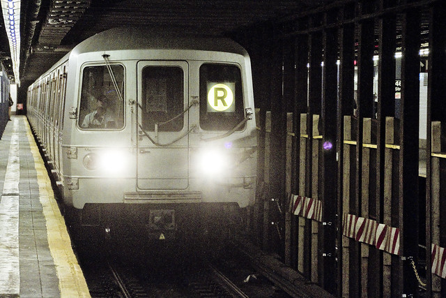
One left Point A in Astoria via the usual means, onboard the so called “R” or Broadway Local Line .
from wikipedia
The R Broadway Local is a rapid transit service in the B Division of the New York City Subway. Its route emblem, or “bullet”, is colored yellow since it uses the BMT Broadway Line in Manhattan.
The R operates local between 71st Avenue in Forest Hills, Queens and 95th Street in Bay Ridge, Brooklyn at all times except nights when it short turns at Whitehall Street–South Ferry in Lower Manhattan from Brooklyn.
– photo by Mitch Waxman
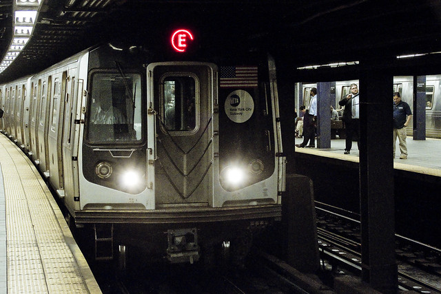
Ultimately, one sought to gain access to the Crosstown or “G” line, which the MTA folks annoyingly force one to enact two transfers to get to from Point A, despite the platform’s location less than a mile and a half from my starting point (and the fact that the G used to run through the same station which I caught the R at). Accordingly, at the sweltering bunker of dripping masonry which the MTA designates as “Queens Plaza,” one debarked the R and vouchsafed a single station ride upon the “E” – or Eighth Avenue Local Line – to the Court Square station where yet another transfer was enacted to access the G.
Urine, it smelled deeply of urine, at the Court Square station.
from wikipedia
The E Eighth Avenue Local is a rapid transit service in the B Division of the New York City Subway. Its route emblem, or “bullet”, is blue since it uses the IND Eighth Avenue Line in Manhattan.
The E operates at all times between Jamaica Center–Parsons/Archer in Jamaica, Queens, and Chambers Street–World Trade Center in Lower Manhattan, running express on the IND Queens Boulevard Line in Queens (except nights when it serves all stops) and local in Manhattan. E trains also serve two local stops in eastern Queens (75th Avenue and Briarwood) on evenings and weekends.

– photo by Mitch Waxman
My penultimate destination, on this particularly warm evening, was Sunset Park – which adjoins the legend choked streets of the Red Hook section of Brooklyn. One does realize, of course, that the R could have taken me all the way to this area which is called “Sunset Park,” but that would have multiplied my travel time due to a circuitous route which transverses all of Manhattan and a good chunk of Brooklyn.
The G discharged a humble narrator, vomiting me forth onto the platforms at the sky flung Smith/9th street station, high over the loathsome and shadow haunted Gowanus Canal. The Gowanus Canal smells of urine (and other things) as well, of course.
from wikipedia
The G Crosstown Local is an 11.4-mile-long (18.3 km) rapid transit service in the B Division of the New York City Subway. Its route emblem, or “bullet”, is colored light green since it uses the IND Crosstown Line.
The G operates at all times between Court Square in Long Island City, Queens and Church Avenue in Kensington, Brooklyn via the IND Crosstown and Culver lines. In Queens, it only serves two stations – Court Square and 21st Street, both in Long Island City – but previously served all stations to and from 71st Avenue in Forest Hills on the IND Queens Boulevard Line.
– photo by Mitch Waxman
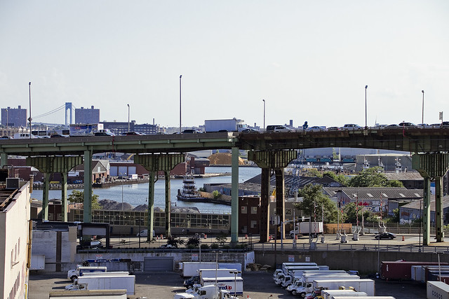
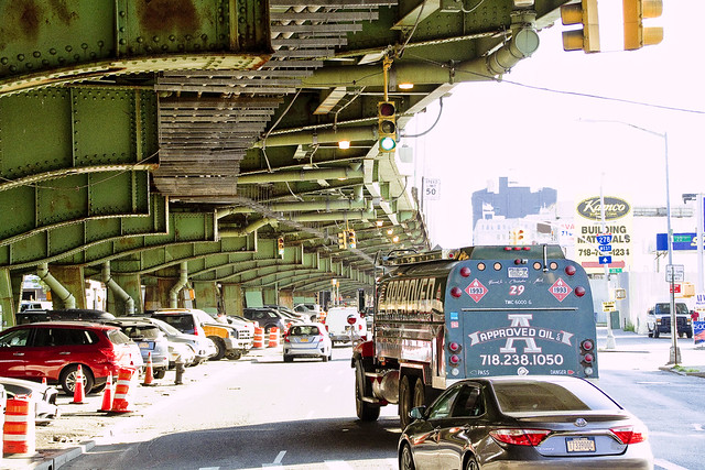
My plan was to pass through the “House of Moses” and under the Gowanus Expressway section of the Brooklyn Queens Expressway, exploiting the shaded path which is offered by this elevated roadway, and head south towards Sunset Park. It should be mentioned, incidentally, that this is perhaps the least pedestrian friendly area in all of Brooklyn. Brobigdagnian trucks whiz about at high speed, angry motorists lurch their vehicles to and fro in frustrated bursts, and the pavement is both shadowed by the expressway above and in a delitorious state of repair.
Also, there’s vampires hiding in the rafters of the Gowanus Expressway.
from nycroads.com
The Gowanus Expressway, which serves as the southern extension of the Brooklyn-Queens Expressway, also connects the Brooklyn-Battery Tunnel approach, the Prospect Expressway (NY 27), the Belt Parkway and the Verrazano-Narrows Bridge. Although guide signs and maps refer to this segment of I-278 as the Brooklyn-Queens Expressway, it is known locally as the Gowanus Expressway.
Beginning in 1939, Robert Moses oversaw construction of the Gowanus Parkway, an elevated highway placed on top of the pillars of the old 3rd Avenue BMT Elevated Line through the Sunset Park and Gowanus sections of Brooklyn. It would eventually become part of a limited-access parkway loop encircling four of the five boroughs. Since the Gowanus Parkway was to be constructed atop a pre-existing elevated facility, Moses had little trouble getting his project approved by the New York City Council.
However, the Gowanus Parkway would require more land for a wide roadway and entrance-exit ramps. This required the demolition of many homes and businesses along Third Avenue, a tightly knit block of Northern and Western European immigrants.

– photo by Mitch Waxman
There are charming sights to be found along the Gowanus Canal, I should mention, lest you think I’m prejudiced against the “Superfund Sister to the South” of my beloved Newtown Creek. Abundant waste transfer and oil distribution facilities, endemic pollution, lakes of unknown chemical constitution lurking just below the streets, untreated sewage oozing out of unmarked pipes? These are all the things I love.
One has never understood the appeal of “going to the country” and vacationing amongst the rural yokels. Camping? Are you insane? I’ve got a dry bed and a door that locks here in NYC, where I get to witness a looming infrastructure crisis and unfolding environmental apocalypse whenever I want to.
from wikipedia
The Gowanus Canal is a canal in the New York City borough of Brooklyn, on the westernmost portion of Long Island. Connected to Gowanus Bay in Upper New York Bay, the canal borders the neighborhoods of Red Hook, Carroll Gardens, and Gowanus, all within South Brooklyn, to the west; Park Slope to the east; Boerum Hill and Cobble Hill to the north; and Sunset Park to the south. It is 1.8 miles (2.9 km) long. There are seven bridges over the canal, carrying Union Street, Carroll Street (a landmark), Third Street, Ninth Street, Hamilton Avenue, the Gowanus Expressway, and the IND Culver Line of the New York City Subway.

– photo by Mitch Waxman
That’s part of the Gowanus Canal, pictured above, as shot from the Hamilton Avenue Bridge and looking back north towards the Smith/9th street station which the G line disgorged me into. Used as I am to the wild expanses and geographic extent of Newtown Creek, my thoughts always turn to compactness when I’m at the Gowanus. Thing is, just like Newtown Creek and its tributaries – two of which the Gowanus would tuck neatly into – the canal interacts with ground water and flows beneath the streets via its connections with the sewer system. Just like Newtown Creek, many of the sewers connected to the Gowanus are in fact former tributary waterways which were converted and buried at the end of the 19th and start of the 20th centuries. Who can guess, all there is, that might be buried down there?
Additionally, both Gowanus Canal and Newtown Creek sport maritime industrial bulkheads along most of their length which are little more than artifacts of the Second Industrial Age, in our modern day NYC.
from nyc.gov
The Hamilton Avenue Bridge is a bascule bridge with two parallel leafs, one carrying the northbound roadway and the other carrying the southbound roadway. Most of the length of Hamilton Avenue runs below the elevated portion of the Gowanus Expressway, including the bridge. The bridge connects Smith Street and Second Avenue over the Gowanus Canal and is the first canal crossing north of the Gowanus Bay.

– photo by Mitch Waxman
Regardless of musings about the wasted space, lack of public access, and utter degradation of the air, water, and soil – one had somewhere to be, and a little bit of walking was required to get there. A humble narrator put his head down, leaned into a southerly declination, and scuttled off into the clouds of auto exhaust mixing with the humid air.
The Gowanus Expressway dwelling Vampires be damned, I needed to get to Sunset Park.
from wikipedia
A vampire is a being from folklore that subsists by feeding on the life essence (generally in the form of blood) of the living. In European folklore, vampires were undead beings that often visited loved ones and caused mischief or deaths in the neighbourhoods they inhabited when they were alive. They wore shrouds and were often described as bloated and of ruddy or dark countenance, markedly different from today’s gaunt, pale vampire which dates from the early 19th century.
Vampiric entities have been recorded in most cultures; the term vampire, previously an arcane subject, was popularised in the West in the early 19th century, after an influx of vampire superstition into Western Europe from areas where vampire legends were frequent, such as the Balkans and Eastern Europe; local variants were also known by different names, such as shtriga in Albania, vrykolakas in Greece and strigoi in Romania. This increased level of vampire superstition in Europe led to mass hysteria and in some cases resulted in corpses being staked and people being accused of vampirism.
Upcoming Tours and events
The Insalubrious Valley of the Newtown Creek Walking Tour, with Newtown Creek Alliance – Saturday August 5th, 11 a.m. – 1;30 p.m.
Century old movable bridges, the remains of a 19th century highway between Brooklyn and Queens, and explore two of the lesser known tributaries of the troubled Newtown Creek watershed. For the vulgarly curious, Conrad Wissell’s Dead Animal and Night Soil wharf will be seen and described, with NCA Historian Mitch Waxman – details here.
Brooklyn Waterfront Boat Tour, with Working Harbor Committee – Saturday August 12th, 6 p.m. – 8 p.m.
Explore the coastline of Brooklyn from Newtown Creek to Sunset Park, with NCA Historian Mitch Waxman, Andrew Gustafson of Turnstile Tours, and Gordon Cooper of Working Harbor Committee on the narrating about Brooklyn’s industrial past and rapidly changing present. – details here.
The Poison Cauldron of the Newtown Creek Walking Tour, with Newtown Creek Alliance – Sunday August 13th, 11 a.m. – 1:30 p.m.
Explore the hellish waste transfer and petroleum districts of North Brooklyn on this daring walk towards the doomed Kosciuszko Bridge, with NCA Historian Mitch Waxman – details here.
Two Newtown Creek Boat Tours, with Newtown Creek Alliance and Open House NY – Wednesday August 16th, 5 p.m. and 7 p.m.
The neighborhoods surrounding Newtown Creek are home to the densest collection of these garbage facilities anywhere in the city and collectively, the waste transfer stations around and along Newtown Creek handle almost 40% of the waste that moves through New York. Join Newtown Creek Alliance’s Mitch Waxman and Willis Elkins to learn about the ongoing efforts to address the environmental burden that this “clustering” has caused. – details here.
“follow” me on Twitter- @newtownpentacle
stinking marsh
It’s National Junk Food Day, in these United States.
– photo by Mitch Waxman
As the shots from my latest adventure are finally done with the developing process but I haven’t had the chance to write and research as of yet, a single shot greets you today, at this – your Newtown Pentacle. Depicting a section of Brooklyn’s Third Avenue in Sunset Park, which is likely the least pedestrian friendly section of the entire borough of Brooklyn, that’s the Gowanus Expressway on the left.
Upcoming Tours and events
The Poison Cauldron of the Newtown Creek Walking Tour, with Atlas Obscura – July 22nd, 11 a.m. – 2 p.m..
Explore the hellish waste transfer and petroleum districts of North Brooklyn on this daring walk towards the doomed Kosciuszko Bridge, with NCA Historian Mitch Waxman – details here.
“follow” me on Twitter- @newtownpentacle
quiet steps
It’s National Caviar Day, in these United States.

– photo by Mitch Waxman
The shot above was captured at the corner on the Astoria side of Northern Blvd. and 47th street, a couple of weeks ago. If it was shot a hundred years ago, this location would have been described as the corner of Jackson Avenue and 17th avenue (aka 19th century Oakley Street) nearby Long Island City’s border with Woodside. Back then, there would have been streetcars (trolleys) rolling through the shot. That’s the sort of thing which I wish the NYC EDC’s BQX team would think about – putting streetcars back where they belong, along these old routes currently serviced by MTA’s buses. This particular trolley route was one that rolled off the Queensborough Bridge, the New York and Queens County Railroad.
The street grid of modern day Sunnyside continued through to the north towards Astoria across what’s now the Sunnyside Yards and those huge used car dealerships you see in the shot above, which are found on the southern side of Northern Blvd. in modern times.

– photo by Mitch Waxman
Northern Blvd. is a widened version of Jackson Avenue, which is another one of the many road projects overseen by Robert Moses in the early 20th century. Another one of Mr. Moses’s projects was both the creation of the Grand Central Parkway (which fed traffic to his Triborough Bridge from Eastern Queens and Long Island) and the redesignation of Astoria Avenue into Astoria Blvd.
FDNY’s Engine 263 and Ladder 117 are housed in a consolidation era firehouse, pictured above, which predates the Grand Central’s construction. There’s a shot of the place from ca. 1920 you might be interested in perusing at this dcmny.org link which shows what things looked like back in the post WW1 period here in Western Queens. The historic shot looks west down Astoria Avenue towards Steinway Street.

– photo by Mitch Waxman
That’s the Long Island Rail Road as it rolls out of the 1870 vintage LIC Passenger Yard towards the Hunters Point Station. The incredible trainsarefun.com is an invaluable resource for studying this particular rail empire, and they offer this incredible aerial image from 1940 which shows the LIRR operation at probably its grandest moment.
Upcoming Tours and events
The Poison Cauldron of the Newtown Creek Walking Tour, with Atlas Obscura – July 22nd, 11 a.m. – 2 p.m..
Explore the hellish waste transfer and petroleum districts of North Brooklyn on this daring walk towards the doomed Kosciuszko Bridge, with NCA Historian Mitch Waxman – details here.
“follow” me on Twitter- @newtownpentacle
old privateers
It’s National Peach Ice Cream Day, in these United States.

– photo by Mitch Waxman
One believes that if you’ve got a problem to solve, the first step towards “victory state” over it involves wrapping your head around the problem and “getting smart.” I like to be fairly well educated about the nature of things before opening the hood and tinkering around with the engine, basically.
The subject of the MTA, or Metropolitan Transit Authority (a public benefit corporation), has been in the news quite a bit of late. The subways have been the particular focus, but the question a friend asked me the other night is what caused today’s post to come into existence.
What, exactly, is the MTA? Well, it’s complicated.
from wikipedia
Chartered by the New York State Legislature in 1965 as the Metropolitan Commuter Transportation Authority(MCTA), it was initially created by Governor Nelson Rockefeller to purchase and operate the bankrupt Long Island Rail Road. The MCTA dropped the word “Commuter” from its name and became the Metropolitan Transportation Authority (MTA) on March 1, 1968 when it took over operations of the New York City Transit Authority (NYCTA) (now MTA New York City Transit (NYCT)) and Triborough Bridge and Tunnel Authority(TBTA) (now MTA Bridges and Tunnels (B&T)). The construction of two bridges over the Long Island Sound was put under the jurisdiction of the MTA.
– photo by Mitch Waxman
To begin with, there’s just over 70,000 employees on the MTA’s payroll. MTA operates, ultimately, in the most densely populated sections of three states with the Shining City of Manhattan as the titular center and bullseye destination for its trains, automotive bridges and tunnels, and multiple fleets of buses.
Nearly all of the MTA train lines were originally built and owned by private businesses (with a significant public investment in the case of the subways) either during the late 19th or early 20th century, but bankruptcies and public foreclosures brought them into government hands. Private bus companies were acquired and folded into the Authority over the decades, along with bridges and tunnels that were formally owned and operated by seperate entities. Today, all of these operations are handled by the individual divisions of the MTA and overseen by a 17 member board of directors (who are all political appointees with virtually zero experience in transportation matters, incidentally).
from wikipedia
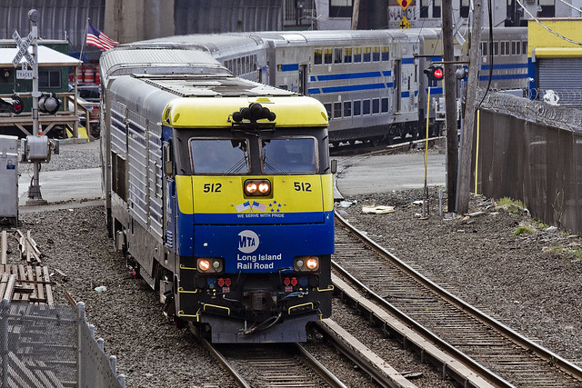
The Long Island Rail Road (reporting mark LI), legally known as the Long Island Rail Road Company and often abbreviated as the LIRR, is a commuter rail system in the southeastern part of the U.S. state of New York, stretching from Manhattan to the eastern tip of Suffolk County on Long Island. With an average weekday ridership of 337,800 passengers in 2014, it is the busiest commuter railroad in North America. It is also one of the world’s few commuter systems that runs 24 hours a day, 7 days a week, year-round. It is publicly owned by the Metropolitan Transportation Authority, which refers to it as MTA Long Island Rail Road.

– photo by Mitch Waxman
Capital Construction is where all the money disappears into, basically. Pictured above is the Second Avenue Subway under construction, and however much I wish that I could show you a shot from the East Side Access project – I haven’t managed to find a way to get my camera down there, yet. The MTA is ostensibly meant to be self funding, through bonds it issues and through fare revenue, but it seldom works out that way and both State and City end up sending a significant amount of tax revenue their way to handle deficits.
Everybody asks why it is that these mega projects orchestrated by Capital Construction have the political support that they do while the wheels are falling off the buses and subways. Short answer is that a shot of a politician watching some mechanic turn a wrench while repairing a track switch is a lot less compelling an image, electoral politics wise, than one showing the same politician cutting a ribbon at the opening ceremony of a fancy new subway stop in the richest section of Manhattan on the Uppper East Side.
Capital Construction, like all of MTA’s divisions, is a vertical silo with its own hierarchy and political patronage. They do what they do, and compete for funding with the other divisions.
from wikipedia
MTA Capital Construction is a subsidiary agency of the Metropolitan Transportation Authority (MTA), formed in July 2003 to manage the MTA’s major capital projects in the New York metropolitan area. It mainly focuses on improving transportation infrastructure and facilities in New York City, the Hudson Valley, and Long Island areas. Funding primarily comes from local, state, and national bond sales and budgets. As of April 2017, the current MTA Capital Construction president is Janno Lieber.

– photo by Mitch Waxman
Long Island Railroad, for instance, is a vertically integrated “thing” all of its own. If someone from the Metro North side of MTA calls in sick, they don’t send LIRR employees upstate to fill in the slack. It doesn’t share “synergies” with Metro North (repair facilities, union contracts etc.) or with the New York City Transit Authority (subways). This situation is owed partially to the formerly seperate corporate entities that created the original lines.
Metro North is the grandchild of the old New York Central Railroad passenger service, and the LIRR is the child of Central’s arch rival and adversarial enemy – the Pennsylvania Railroad Company.
I’m no expert on this subject, so, I reached out to a buddy who is one of my “rail rabbis” and he anonymously offered this statement and assessment of the situation involving Metro North and LIRR, which – despite logic and what you might think, don’t use the same trains nor operate in common fashion or custom.
“Metro-North Railroad is made up of three distinct operations. Two of these operate out of Grand Central Terminal, the third operates out of Hoboken Terminal.
Hudson and Harlem lines are the remnants of the New York Central Railroad (Vanderbilt), out of Grand Central Terminal.
The New Haven line is the former New York, New Haven and Hartford Railroad (New Haven for short).
The New Haven was unique in that they operated commuter trains out of Grand Central Terminal and their long distance trains out of Penn Station. The line over Hell Gate was financed by the New York Connecting Railroad, which was a paper railroad business agreement between the New Haven and the Pennsylvania Railroads.
The third operation is frequently overlooked. it is the former Erie Railroad (Jay Gould, THE robber baron), later Erie Lacawanna Railroad operation to Port Jervis New York. MTA pays for the New York portion, while New Jersey Transit pays for the New Jersey operation. This operates out of Hoboken Terminal.
The New York Central and Pennsylvania Railroad merged in 1968 into the Penn Central (Good book to read is “The Wreck of the Penn Central” by Joseph R. Daughen and Peter Binzen).
It was an unhappy merger, with battles between the two different management ideologies. It ended up with the US Government creation of Conrail in 1976 to salvage what remained of several north east railroad operations (Including Penn Central).
Conrail operated many commuter railroads, which received state subsidies for commuter operations. (Amtrak was formed in 1971 for intercity/long distance passenger trains, not the many commuter operations) Conrail wanted out of commuter operations at its founding and in 1983, it was NY States turn and Metro North was created.
The LIRR and Metro North are two distinct systems, with the only real compatible technology being the train couplings and the gauge of the trains.
Metro North utilizes an under-running third rail and the LIRR utilizes an over running third rail. Diesel locomotives and diesel hauled electric passenger cars also weigh different, with Metro North being able to haul heavier equipment, Long Island bridges are load limited. The Park Avenue Tunnels on Metro North and the East River Tunnels on the Long Island also limit the interchangeability of some equipment. Signal systems are also different.
The Electric Multiple Unit (MU) trains of Metro North and LIRR look similar and are ordered from the same vendor/companies, but they are configured to operate on their respective systems. They are not freely interchangeable. The Arch Street shop of the LIRR is a warranty shop for the recent purchase of the M-7 MU’s. Metro north ships them there for work, but not before all the third rail shoes are removed, and they have to travel over the Hell Gate from New Rochelle, NY. (The Ventilation system vents on the Metro North Roofs won’t fit in the LIRR East River Tunnels).
The LIRR bilevel cars will not fit in the Park Avenue tunnels.
Metro North diesel locomotives are too heavy for the bridges on the eastern end of Long Island.”
from wikipedia
The Metro-North Commuter Railroad (reporting mark MNCW), trading as MTA Metro-North Railroad or simply Metro-North, is a suburban commuter rail service run by the Metropolitan Transportation Authority (MTA), a public authority of the state of New York. With an average weekday ridership of 298,900 in 2014, it is the second-busiest commuter railroad in North America in terms of annual ridership, behind its sister railroad, the Long Island Rail Road. Metro-North runs service between New York City and its northern suburbs in New York and Connecticut, including Port Jervis, Spring Valley, Poughkeepsie, White Plains, and Wassaic in New York and New Canaan, Danbury, Waterbury, and New Haven in Connecticut. Metro-North also provides local rail service within New York City at a reduced fare. There are 124 stations on Metro-North Railroad’s five active lines (plus the Meadowlands Rail Line), which operate on more than 775 miles (1,247 km) of track, with the passenger railroad system totaling 385 miles (620 km) of route.

– photo by Mitch Waxman
Another vertical silo at MTA is the Bridges and Tunnels group. This is Robert Moses’ old Triborough Bridge and Tunnel Authority empire, rebranded and “nationalized” by Nelson Rockefeller back in the late 1960’s. TBTA has always been, and always will be, its own fiefdom.
For those of you not familiar with the terms “vertical silo” or “synergies,” that’s a fairly archaic series of terms used in the investment banking industry to describe business units within a corporate structure. When a corporate merger occurs, the investment bankers will often try to “flatten” these silos and merge them with other units to avoid redundancy, which saves them money and ostensibly streamlines an operation. This is not how Government people think, btw. If the MTA was a company and got taken over by another corporation, the VERY first thing the new owners would do is try to flatten these silos and eliminate the wasteful or redundant departments.
MTA, for instance, has multiple divisions of armed police and guardsmen. There’s TBTA cops, MTA cops, MTA Operations armed guards, a whole seperate department of MTA Security… and they’re all operating under different rules, jurisprudence, and circumstance.
It’s all very complicated.
from wikipedia
The Triborough Bridge and Tunnel Authority, doing business as MTA Bridges and Tunnels, is an affiliate agency of the Metropolitan Transportation Authority that operates seven intrastate toll bridges and two tunnels in New York City. In terms of traffic volume, it is the largest bridge and tunnel toll agency in the United States, serving more than a million people each day and generating more than $1.5 billion in toll revenue annually as of 2012.
The seven bridges are:
- Triborough Bridge (officially Robert F. Kennedy Bridge), the agency’s original namesake and flagship crossing, connecting Manhattan, the Bronx, and Queens, via Randalls and Wards Islands
- Bronx–Whitestone Bridge, connecting the Bronx and Queens
- Verrazano-Narrows Bridge, connecting Brooklyn and Staten Island
- Throgs Neck Bridge, connecting the Bronx and Queens
- Henry Hudson Bridge, connecting Manhattan and the BronxMarine Parkway–Gil Hodges Memorial Bridge, connecting Brooklyn and the Rockaways (Queens)
- Cross Bay Veterans Memorial Bridge, connecting Broad Channel to the Rockaways (Queens)
The two tunnels are:
- Brooklyn–Battery Tunnel (officially Hugh L. Carey Tunnel), connecting Brooklyn and Manhattan
- Queens–Midtown Tunnel, connecting Queens and Manhattan

– photo by Mitch Waxman
The focus of public ennui these days is generally related to the subway system, although this summer the LIRR situation has gathered a lot of storm clouds to the Long Island Railroad. What New Yorker hasn’t stood there on some subway platform and exhorted “EFF YOU, MTA” at least once?
My rail rabbi quoted above offers this, on the subject of the “switch problems” and the MTA’s promises that modernizing them will fix everything wrong with the subways:
“One thing we mentioned about “outdated signal systems” with regard to the subway is that the 100 year old signal, while worn out, allow better utilization of the tracks. As I understand it, typical headways on the NYC subway system are four to seven minutes at rush hour. As a comparison, newer fully automated systems, like BART in San Francisco, WAMATA in Washington DC and MARTA in Atlanta can’t beat seven minutes, with ten minutes being the normal.”
A humble narrator has been getting increasingly involved with transit issues in recent years, and I’ve joined the steering committee of Access Queens, a community organization led by Sunnyside’s Melissa Orlando, which grew out of the “7 train blues” Facebook group. I won’t bore you with the usual song you’ve read everywhere else about switches, overcrowding, deferred maintenance, and aging tracks – instead I’d ask for you to click through to the Access Queens site and see what our group has been working on.
It may be the “Summer of Hell” for the LIRR, but it’s always transit hell in Queens.
from wikipedia
The New York City Transit Authority (also known as NYCTA, The TA or simply Transit, and branded as MTA New York City Transit) is a public authority in the U.S. state of New York that operates public transportation in New York City. Part of the Metropolitan Transportation Authority, the busiest and largest transit system in North America, the NYCTA has a daily ridership of 7 million trips (over 2 billion annually).
The NYCTA operates the following systems:
- New York City Subway, a rapid transit system in Manhattan, The Bronx, Brooklyn, and Queens.
- Staten Island Railway, a rapid transit line in Staten Island (operated by the Staten Island Rapid Transit Operating Authority, a NYCTA subsidiary)
- New York City Bus, an extensive bus network serving all five boroughs, managed by MTA Regional Bus Operations.

– photo by Mitch Waxman
The MTA Bus company is part of NYCTA, or New York City Transit Authority, but that’s not all of it. There’s tons of bus lines in Nassau and Suffolk Counties, Yonkers, and even Westchester which MTA operates. Buses aren’t the sexiest way to get around, of course, but when it’s raining a bus is always superior to walking. Unfortunately, the vertical silo of the bus company seldom coordinates with the NYCTA subway company during outages and planned work, nor coordinates their schedule with them.
from wikipedia
MTA Regional Bus Operations (RBO) is the surface transit division of the Metropolitan Transportation Authority (MTA), created in 2008 to consolidate all bus operations in New York City operated by the MTA.
Upcoming Tours and events
The Poison Cauldron of the Newtown Creek Walking Tour, with Atlas Obscura – July 22nd, 11 a.m. – 2 p.m..
Explore the hellish waste transfer and petroleum districts of North Brooklyn on this daring walk towards the doomed Kosciuszko Bridge, with NCA Historian Mitch Waxman – details here.
“follow” me on Twitter- @newtownpentacle
secret assemblages
It’s National Mac & Cheese Day, in these United States.

– photo by Mitch Waxman
Well, I guess it’s kind of been “Creek Week” around these parts this last week, so let’s finish things up with a tugboat!
As mentioned in Monday’s post, one has been desirous of capturing a few last shot of the old Koscisuzcko Bridge before its deconstruction is engaged, just for the record… y’know? While setting up my gear for a night shoot, the Donjon Tug Brian Nicholas, which appeared in Wednesday’s post briefly, suddenly appeared. I hadn’t affixed the camera to the tripod yet, so I got busy with the clicking and the focusing.

– photo by Mitch Waxman
Brian Nicholas has been in many, many posts at this – your Newtown Pentacle – over the years. Just below is my favorite ever shot of this tug, from 2012.

– photo by Mitch Waxman
Some 75 feet long, with a gross tonnage of 104 GRT, the Brian Nicholas is owned by DonJon towing and powered by 2 850 HP engines. Brian Nicholas was built in 1966 and retrofitted in 2010 as a “green tug.”
from docs.google.com
This past June, Donjon completed the top-to-bottom refit and replacement of the main engines, generators, gears and related equipment of its tug Brian icholas. The refit was performed in house at Donjon’s Port Newark, New Jersey facility under the supervision of Donjon’s Gabe Yandoli and Robert Stickles. As a result of the refit, the Brian Nicholas is now a “green” tug, compliant with all applicable EPA and Tier 2 marine emissions regulations.
The rebuild included a repowering of the main propulsion with Cummins K38-M Marine engines, which were specifically developed by Cummins to meet EPA and Tier 2 marine emissions regulations. The new engines also meet the IMO, MARPOL and EU Stage 3A requirements. Similarly, the generators were upgraded to incorporate John Deere 4045TFM75 engines, also Tier 2 compliant. In addition to the replacement of the aforementioned engines, the project required virtually total replacement of exhaust lines and routing of new control lines and panels in the engine room and wheelhouse.

– photo by Mitch Waxman
Brian Nicholas was towing a barge of what looked like shredded metals and construction debris, which would mean that it’s coming from one of the waste transfer locations found along the English Kills tributary further east.
As I’ve said in the past – whether they’re pushing or pulling, tugs are always towing – that’s what the term is.

– photo by Mitch Waxman
Brian Nicholas was headed for the East River, and ultimately it would likely head over to New Jersey, where the recyclable metals on its barge could be packaged up, loade on a container ship, and be then sold on a global commodities market.
See you next week, with something completely different, at this – your Newtown Pentacle. Also, I’m doing a tour of Dutch Kills tomorrow – come with? I’ll show you something cool.
Upcoming Tours and events
13 Steps Around Dutch Kills Walking Tour, with Newtown Creek Alliance – July 15th, 10 a.m. – 1 p.m..
The “then and now” of Newtown Creek’s Dutch Kills tributary in LIC, once known as the “workshop of the United States.” with NCA Historian Mitch Waxman – details here.
The Poison Cauldron of the Newtown Creek Walking Tour, with Atlas Obscura – July 22nd, 11 a.m. – 2 p.m..
Explore the hellish waste transfer and petroleum districts of North Brooklyn on this daring walk towards the doomed Kosciuszko Bridge, with NCA Historian Mitch Waxman – details here.
“follow” me on Twitter- @newtownpentacle
