Posts Tagged ‘Pickman’
doom that
Kosciuszko Bridge visit, a few random things I noticed.

– photo by Mitch Waxman
A couple of days back, a fairly enormous posting detailed the latest visit to the Kosciuszko Bridge replacement project in Greenpoint. The shots in today’s post were candidates for that post, but I had to draw a certain line in the name of being concise in terms of the overall narrative. It was a progress report, after all. Today, some of the cool stuff I saw which didn’t fit into the structure thereof.
I love taking shots of people welding or working with metal and torches. There’s two ways to approach this shot, btw. One is to use a high ISO and insanely fast shutter speed to freeze the individual sparks. The other is to lower the ISO sensitivity and use a slower shutter. The shot above uses the former approach, which freezes all the little sparks. The latter approach allows the sparks to stretch out and look like fiery spaghetti.

– photo by Mitch Waxman
The shot above is from up on the still under construction roadway and overlooks the National Grid site in Greenpoint. I don’t know ANYONE who has ever personally visited this site, and it remains one of the “black boxes” on the Newtown Creek. By “black box” I mean that it’s like fight club when you ask the National Grid Guys about it, and you don’t talk about fight club. This is looking easterly, towards Maspeth.

– photo by Mitch Waxman
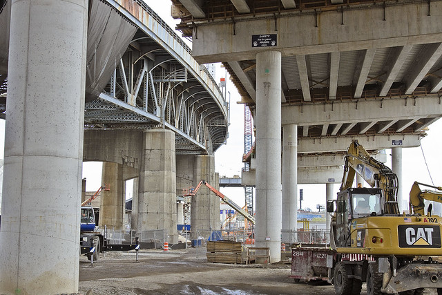
Turning on my heels, as it were, and looking south along Meeker Avenue/Brooklyn Queens Expressway towards Manhattan. For some reason, the chattering lunatic voice which constantly wails between my ears and behind my eyes has started referring to Manhattan as “Manchuquo” in recent weeks. I don’t know why. It won’t be the first time that I remind you that I’m an idiot.

– photo by Mitch Waxman
The Kosciuszko Bridge, Brooklyn side, is absolutely surrounded by waste transfer stations. Something close to 40% of NYC’s trash (by ton) comes to within about a mile of the bulkheads of Newtown Creek and its tributaries for processing. Last time I checked, the City generates about 12 million tons of trash a day, and since I’m mathematically challenged – I’ll allow you to do the calculations.

– photo by Mitch Waxman
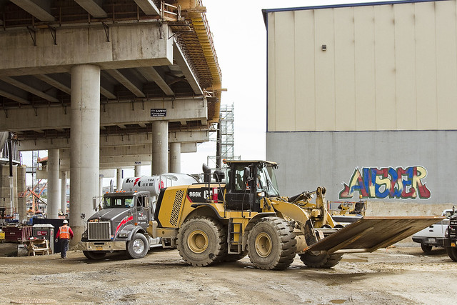
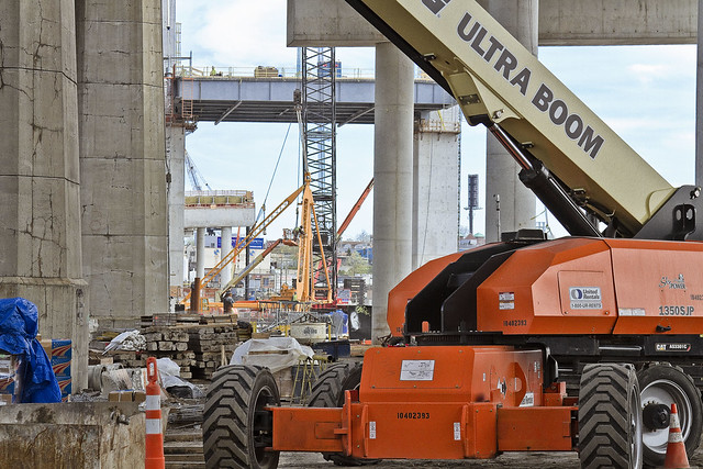
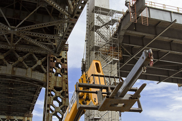
Gear, gear, gear. These construction guys have the coolest toys to play with you’ve ever seen. The vehicle above had some sort of crane/winch thing on it which appeared to be able to telescope out of the hydraulic boom that was set into the rear of its chassis, scorpion style. This particular device seemed to be just a few generations away from the the exoskeleton rig that Ripley used in the movie “Aliens.”

– photo by Mitch Waxman
This shot came from a temporary staircase set against the new overpass’s abutment/retaining wall. This has to be around 50-60 feet up from the deck. One of my many, many phobias – albeit a minor affliction in my portfolio – involves heights. In my mind, it’s a good defense mechanism, as falling 50-60 feet will kill you dead. Saying that, just looking at this picture causes neurological symptoms to manifest in the muscles controlling my hands.
Upcoming Events and Tours
Sunday, May 8th at 11 a.m. – North Henry Street Project,
with Municipal Arts Society Janeswalk and Newtown Creek Alliance,
in Greenpoint, Brooklyn. Click here for more details.
“follow” me on Twitter- @newtownpentacle
fetter upon
Wandering the post industrial wastelands of America’s Work Shop – that’s me.

– photo by Mitch Waxman
Spotted the numeral above in LIC recently, adorning the loading dock of some nameless warehousing company housed in the former Waldes Koh-I-Noor site nearby Dutch Kills. The Real Estate Industrial Complex recently discovered the former Degnon Terminal, it seems, and the Waldes buildings are currently being marketed as “The Zipper Building” by the powers that be and to opportunists who have connected themselves to LIC as some sort of stepping stone from Wall Street.
As a note, five is the only prime number that ends with the number five. It’s also the only number which seems to be entirely European in origin, having little verisimilitude to Arabic or Indian glyphs that represent the number. There’s five senses, five books in the Torah, five wounds of Jesus, five pillars of Islam, and in western music – a perfect fifth is considered to be the most consonant of all the harmonies. In geometry, there’s the Pentagram, and of course – you’re reading the pentacle.
Five.

– photo by Mitch Waxman
Speaking of Dutch Kills, when you see a structure of creosoted logs held together with iron, as you do nearby the Hunters Point Avenue Bridge – the official term for this sort of thing is a “dolphin.” It’s meant to vouchsafe the bridge against an accidental collision by maritime traffic, but since there’s little to no maritime traffic on Dutch Kills – a tributary of the legendary Newtown Creek – these days, it’s just a thing to take pictures of.
There’s twelve former trees, infused with creosote oil, in that shot above.
Twelve is thought to be a Germanic/Old English term describing the smallest composite number which has exactly six divisors. It’s the largest number that has a single syllable name in the English language. A cube has twelve edges, the human body has twelve cranial nerves. The Western zodiac has twelve signs, as does the Chinese variant, and the 12th moon of Jupiter is called Lysithea.
Twelve.

– photo by Mitch Waxman
From the Newtown Creek Waste Water Treatment Plant Nature Walk in Greenpoint, should you have a medium long zoom lens on your camera, you can observe the Sims Metal Management Company at work – processing all sorts of metallic things. In the case of the shot above, it’s derelict cars in the process of being recycled. After collection at Sims on Newtown Creek, these automobile carcasses will be barged out to New Jersey where they will be fed into a shredder that will reduce them down to metallic bits and a cloud of dust.
As I count it, there’s eighteen automobiles in the shot above.
The number eighteen translates from the Hebrew word for it (Chai) as “Life.” There’s 18 chapters in the Bhagavad Gita, which is part of the 18 book Mahabharata. Chinese tradition declares the number eighteen as a lucky one. Eighteen in binary code is “10010” which is a seven block long zip code in Manhattan – from 20th to 27th, and from Sixth avenue to the East River.
51218, you ask? According to the National Institue of Helath, that’s the numerical designation of a gene we inherited from our single cell ancestors.
What all of this means, I can’t say, but it’s kind of freaking me out.
Upcoming Events and Tours
Sunday, May 8th at 11 a.m. – North Henry Street Project,
with Municipal Arts Society Janeswalk and Newtown Creek Alliance,
in Greenpoint, Brooklyn. Click here for more details.
“follow” me on Twitter- @newtownpentacle
some passages
Kosciuszko Bridge project, Brooklyn side, Q2 2016, in today’s post.
– photo by Mitch Waxman
The invitation went out to all the concerned parties – inclusively referred to as the Stakeholders Advisory Group – from the NYS DOT that an opportunity to observe the progress of the Kosciuszko Bridge replacement project was once again at hand.
Accordingly, a humble narrator collected together the camera and lenses, and set off for Greenpoint’s DUKBO – Down Under the Kosciuszko Bridge Onramp.
Several progress reports have been offered on the NYS DOT’s Kosciuszko Bridge replacement project. I seem to be the only person In New York paying any attention to the project, and there’s been a series of prior posts on the bridge presented at this – your Newtown Pentacle – chronicling the project.
To start – this 2012 post tells you everything you could want to know about Robert Moses, Fiorella LaGuardia, and the origins of the 1939 model Kosciuszko Bridge. Just before construction started, I swept through both the Brooklyn and Queens sides of Newtown Creek in the area I call “DUKBO” – Down Under the Kosciuszko Bridge Onramp. Here’s a 2014 post, and another, showing what things used to look like on the Brooklyn side, and one dating back to 2010, and from 2012 discussing the Queens side – this. Construction started, and this 2014 post offers a look at things. There’s shots from the water of Newtown Creek, in this June 2015 post, and in this September 2015 post, which shows the bridge support towers rising. Additionally, this post from March of 2016 detailed the action on the Queens side.
– photo by Mitch Waxman
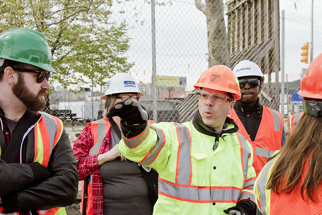
Leading the tour was NYS DOT’s project leader, engineer Robert Adams, who is the fellow pictured above in the stylish (and highly visible) yellow jacket.
Mr. Adams allows me to call him Bob, for which I’m grateful. One such as myself dislikes the usage of extraneous syllables in the spoken form. For the purposes of today’s post, however, I’ll refer to him as Mr. Adams – as the job his team is overseeing has done such an impressive job of staying on or ahead of schedule, he deserves the honorific.
– photo by Mitch Waxman
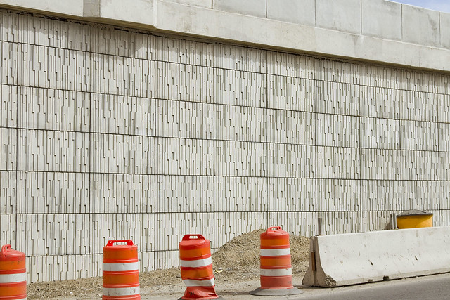
Part of the job, as it were, includes the rerouting of the Brooklyn Queens Expressway section which travels north/south along Meeker Avenue. The new roadway is supported by masonry and steel, and its outer facing is covered in sculptural tiles (which I think are concrete). I asked Mr. Adams if the sculptural motif on the tiles had a particular purpose – diffusing sound, or guiding rain runoff, for instance – but he said that it was purely esthetic, and part of the architectural design.
– photo by Mitch Waxman
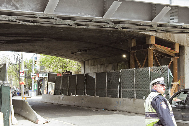
The old overpass abutments on Meeker Avenue are in the process of being dismantled. It’s a fairly chaotic scene down around here – this is the intersection of Vandervoort and Meeker if you’re curious.
Mr. Adams told us that one of the ways in which his team alleviated the impact of construction on traffic flow to the highway above was to build the new abutments “behind” the old ones. When the project is done, this will allow the DOT to add wider pedestrian sidewalks, and to also create an increased amount of space for the required turning radius of trucks as they move under the overpass.

– photo by Mitch Waxman
On the actual job site, in a spot which I refer to as “used to be Cherry Street,” is pictured above. Old school Cherry street is found beneath the masonry structure occupying the left side of the shot above, I would mention, and the unpaved access road at bottom right represents the right of way for “New Cherry Street.”
– photo by Mitch Waxman
Getting down to the action, and there’s a lot of it going on down here in DUKBO. This spot is one of the areas where some of that worksite safety training I’ve mentioned before comes into play. The contractors on the job – Skanska, Kiewit, and ECO3 – all subscribe to “safety culture” which is designed to keep laborers from suffering needless injuries. We – as in the civilian visitors Mr. Adams was escorting around the site – were all dressed up in orange vests, safety glasses, hard hats, and work gloves.
– photo by Mitch Waxman
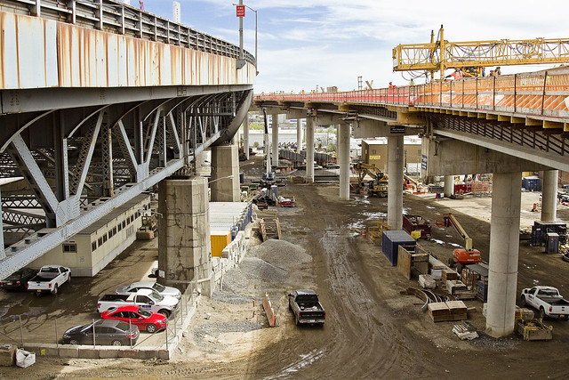
The roadway leading to the new bridge is on the right, with the 1939 vintage Kosciuszko Bridge on the left. We were told that the area down here will actually be available for use as a public space in the post construction era. At a luncheon meeting after the tour, Mr. Adams was petitioning the group for ideas as to what the community might want to happen down here. There will be space available on the Queens side as well.
Speaking of Queens, we were also told that in the early summer, a similar walk-through of the Queens side will be happening. Can’t wait for that one, mainly so I don’t have to walk all the way to Greenpoint from Astoria.
– photo by Mitch Waxman
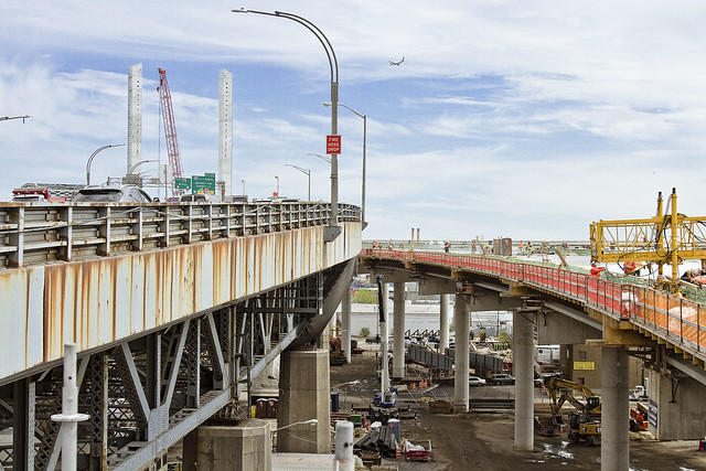
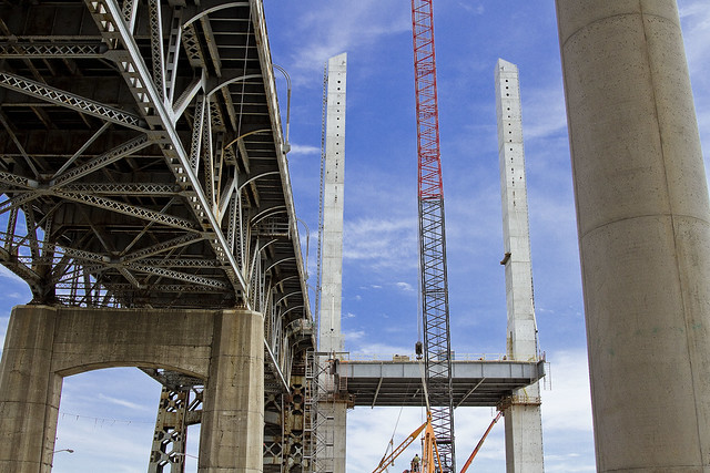
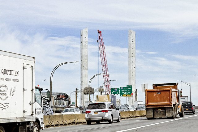
Having crossed Gardiner Avenue, heading south towards the languid waters of Newtown Creek, it was pretty exciting to notice that steel has begun to be affixed to the concrete tower columns of the new bridge – a major milestone. The new Kosciuszko Bridge is going to be of the cable stay variety, and the first of its type in NYC.
– photo by Mitch Waxman
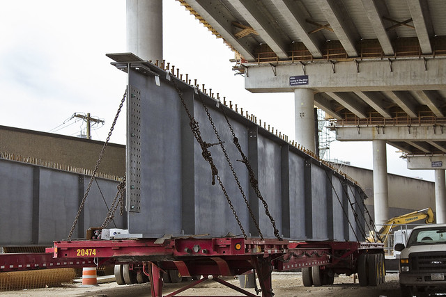
Speaking of steel, there were gigantic chunks of the stuff ready for deployment. These pieces are actually the outward facing sides of the highway. Mr. Adams made it a point of informing us that this was an entirely American produced bridge, with steel coming in from Pennsylvania and concrete sourced from a Queens company that’s called Tek Crete.
– photo by Mitch Waxman
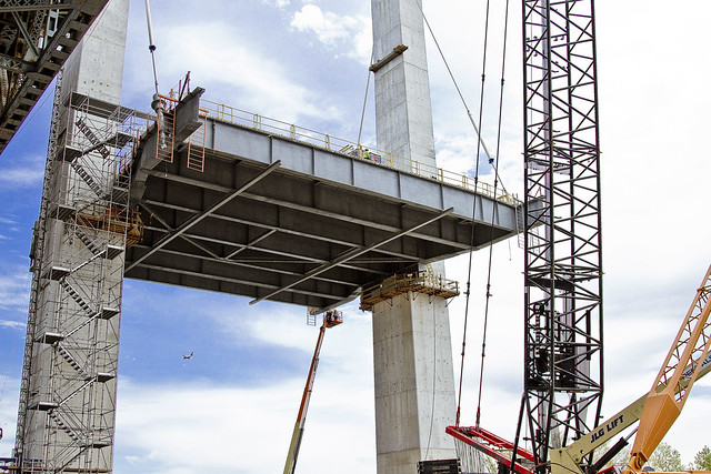
A bit closer to the columns, and rapidly emerging roadway, which will become the easterly half of the new bridge.
The plan from the beginning has been to produce the new span in three distinct stages. First – build the lanes of the eastern side. Second – demolish the 1939 bridge. Third – build the westerly side which will sit in the footprint of the 1939 model. Chatter on the tour indicated that the demolition part of the project will begin in 2017, and that the engineers are still debating as to how best remove the concrete piers which support the steel truss.
The truss itself is actually the easiest part of the job to figure, and the center section is going to be removed in one piece. It will be lowered, by cranes, onto barges which will be towed by tugboats out of Newtown Creek.
– photo by Mitch Waxman
As you can see in the shot above, the first set of cable stays has already been affixed to the new road section. For a sense of scale on how absolutely colossal this project is, take notice the itty bitty construction workers who are on the lift between the two towers.
– photo by Mitch Waxman
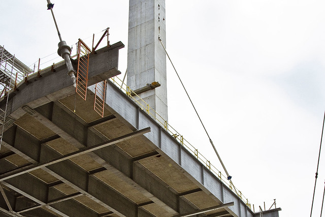
A bit of a better angle showing the cable stays and their anchors on the roadway section. This will be be built out both south – towards Greenpoint and Meeker Avenue – and north, over the water and into Queens.
– photo by Mitch Waxman
Mr. Adams and his team indicated that we were going to be heading back towards Greenpoint, and climbing a temporary stairway up to the still under construction roadway which will be the north bound lanes of the Brooklyn Queens Expressway. Couldn’t resist one last shot from ground level showing the two structures.
– photo by Mitch Waxman
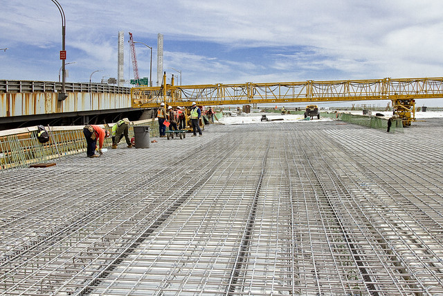
From the temporary stairway, which was around 4-5 stories worth of climbing, and looking north towards Queens.
– photo by Mitch Waxman
The roadway itself is still under construction. The views from up here were fairly epic, but I’ll share those in a future post. Suffice to say that were I to attempt the same shots post construction, I’d be thoroughly squished by traffic moving at highway speeds.
– photo by Mitch Waxman
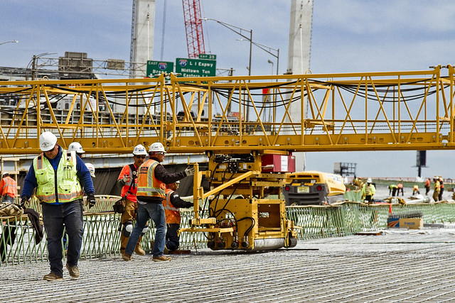
Not sure which Union these fellows were members of, but they were too busy for me to ask. The Union guys were tying off the structural rebar, in preperation of pouring the concrete which would become the underpinning of the BQE’s roadway.
– photo by Mitch Waxman
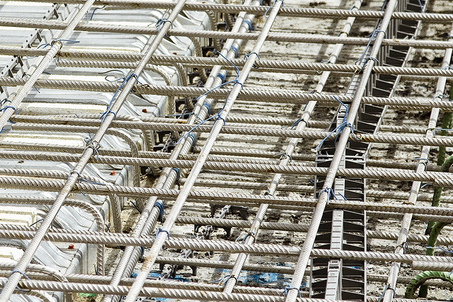
The rebar that these Union guys are installing is actually stainless steel rather than galvanized iron. The extra expense for the stainless is justified in the name of avoiding corrosion, due to the massive amount of salt which is typically applied to the BQE during the winter months.
– photo by Mitch Waxman
One last shot looking north along the 1939 version of the Kosciuszko Bridge. What’s truly interesting to me about this project which Robert Adams is supervising is the fact that at no point can traffic along this Robert Moses built highway be impeded or stopped. It’s analogized best as doing a full rebuild of your car’s transmission, while driving at 90 mph in heavy traffic.
Progress on the Kosciuszko Bridge replacement will continue to be documented, at this, your Newtown Pentacle.
Upcoming Events and Tours
Sunday, May 8th at 11 a.m. – North Henry Street Project,
with Municipal Arts Society Janeswalk and Newtown Creek Alliance,
in Greenpoint, Brooklyn. Click here for more details.
“follow” me on Twitter- @newtownpentacle
into which
I been everywhere, man.

– photo by Mitch Waxman
A humble narrator is fully “back in action” after a long hermitage. In the last seven days – I’ve conducted three walking tours of the Newtown Creek watershed, visited the Kosciuszko Bridge construction project, attended and partcipated in a Working Harbor Committee tour, and have also found myself cathechizing elected officialdom about the dangers of CSO’s (Combined Sewer Outfalls). I also shot and developed a few hundred photos, and you’ll be seeing some of them over the next few days.
I also got to take the most photogenic of NYC’s subway lines the other day, which is the IRT Flushing or 7 line, as evinced by the shot above.

– photo by Mitch Waxman
Two of my walking tours last week were private affairs, and involved exposing groups of students to LIC. I brought the kids down the Dutch Kills tributary of Newtown Creek, then along the main stem of the Creek itself, and we eventually ended up along the East River waterfront in Hunters Point.
The counterpoints between “America’s Workshop” and the “Modern Corridor” are jarring, and seeing the post industrial section contrasted with the gentrified residential sections really seemed to hit home with them. I love taking out groups of students, incidentally, as ultimately our world will be theirs someday, and they have to start thinking up the solutions to the colossal mess we’re going to be leaving behind.

– photo by Mitch Waxman
Funnily enough, what with all the running around, I ended up walking close to forty miles last week as I scuttled around from place to place. This weekend, I’ve got another private group tour on Saturday, but on Sunday there’s a free event I’m helping to conduct with my colleague Will Elkins from Newtown Creek Alliance. Details are found below for attending the “North Henry Street Project,” which will meet up at 11 a.m on the corner of Kingsland and Norman Avenues in Greenpoint.
This one is part of the citywide MAS Janeswalk event, and I’m hoping you can come along and check out the plans NCA has been concocting for the “Unnamed Canal,” a minor tributary of Newtown Creek.
Upcoming Events and Tours
Sunday, May 8th at 11 a.m. – North Henry Street Project,
with Municipal Arts Society Janeswalk and Newtown Creek Alliance,
in Greenpoint, Brooklyn. Click here for more details.
“follow” me on Twitter- @newtownpentacle
unlimited demand
Me? I like a good arch.

– photo by Mitch Waxman
In glorious Astoria, Queens, you’ll notice that the neighborhood hosts a rail viaduct which carries the New York Connecting Railroad tracks to the Hell Gate Bridge, and that the cyclopean concrete structure uses a series of arches to carry the load. Whenever I’m out shooting, a point is made to photograph arches whenever they’re encountered, strictly in the name of “framing” for the composition. These tracks have been here since 1917, and opened in March, or possibly July of that year.
The arch is actually a relatively modern “thing” as far as human history goes, and began turning up in the built environment roughly 4,000 years ago in Mesopotamia.

– photo by Mitch Waxman
The Romans are famous for their usage of the arch and created several twists on the structural element. They would line up a series of arches to create an arcade, or twist them around a focal point to build domes. They also came up with the idea for triumphal arches, like the one you’ll find on the Canal Street side of the Manhattan Bridge, which also has a colonnade.
In case you were wondering – the Manhattan Bridge arch and colonnade were opened for inspection some five years after the bridge itself premiered. It was in 1910, a year after the bridge opened, that the architectural firm Carrère and Hastings drew the plans for the arch, and it was sculpted by Carl A. Heber. There’s also a sculptural frieze called “Buffalo Hunt” by a fellow named Charles Rumsey.

– photo by Mitch Waxman
Speaking of arches and the New York Connecting Railroad, as well as Astoria, you’d be remiss not mention the treasure of treasures which is Hell Gate. Lindenthal and Horbostel designed the great rail bridge, which is actually a series of bridges when you get down to it. The main attraction is an inverted bow spring arch.
Technically speaking, it’s called the East River Arch Bridge.
The New York Connecting Railroad Bridge, aka the East River Arch Bridge- or commonly the Hell Gate Bridge- is estimated to be the most permanent of all the structures garlanding NY Harbor. According to Discover Magazine’s Feburary 2005 issue – it would take a millennium of environmental decay for Hell Gate’s steel to fail and collapse as compared to a mere 300 years for the other East River crossings. A target of no small strategic importance, Hell Gate was a mission objective for the Nazi saboteurs who were landed in Amagansett, Long Island by a Submarine (U-Boat 202– the Innsbruck) during the second World War’s Operation Pastorius. The legal consequences of Pastorius, by the way, are the precedent setting United States Supreme Court decision of Ex Parte Quinn.
Ex Parte Quinn is the legal pretext that underpins the detention of and trial, by military tribunals, of “foreign combatants” in the United States – a central tenet of our modern Terror War.

– photo by Mitch Waxman
My favorite arches can be found at my favorite place, of course. The Greenpoint Avenue Bridge over Newtown Creek is featured above. There have been multiple bridges erected at this location over the years, but the first one was known as the “Blissville Bridge” and it was erected in 1850.
from the DOT website:
The Greenpoint Avenue Bridge is a double-leaf trunnion bascule, with 21.3m wide leaves. This bridge is a steel girder structure with a filled grid deck. The bridge provides a channel with a horizontal clearance of 45.4m and in the closed position a vertical clearance of 7.9m at MHW and 9.4m at MLW. The bridge structure carries a four-lane two-way vehicular roadway with a 1.2m striped median and sidewalks on either side. The roadway width is 8.6m and the sidewalks are 4.0m and 3.7m for the north and south sidewalk respectively. The approach roadways are narrower than the bridge roadway. The west approach and east approach roadways are 17.1m (including 1.4m center median) and 11.9m respectively.
Greenpoint Avenue Bridge is also known as the J.J. Byrne memorial bridge. Who was Byrne? Long story, click here to learn more.

– photo by Mitch Waxman
Over in Staten Island, the Bayonne Bridge opened for use to the general public was 28,856 days ago, on November 15th, 1931 at 5 A.M. Bayonne is the fourth longest steel arch bridge upon the entire planet, and was designed by Othmar Amman. Click here for more on the Bayonne Bridge, and the construction project underway which is raising its roadway to accommodate a new class of cargo vessel.
“follow” me on Twitter- @newtownpentacle


