Posts Tagged ‘Pickman’
drifting sand
Sigh… the Steinway Mansion, in today’s post.

– photo by Mitch Waxman
On the subject of controversies I generally stay away from, the Steinway Mansion is one.
My plate is full, frankly. I’ve got Sunnyside Yards, Newtown Creek, and a good stretch of the East River to worry about – which virtually no one else pays any attention to. The Steinway Mansion is found on the forbidden north coast of Queens, in an off putting industrial zone which isn’t exactly a visually stunning spot.
Frequent Newtown Pentacle commenter George the Atheist has been paying close attention to the controversial sale and development of the Steinway Mansion property, as has the Greater Astoria Historic Society. As I said, my plate is full, but last week I decided to scuttle over and take a gander at what’s going on.
If this mansion was in Brooklyn, or Manhattan, it would have long ago been landmarked and protected – but as you know the borough motto is “Welcome to Queens, now go fuck yourself.”

– photo by Mitch Waxman
The neighborhood surrounding the former home of William Steinway, who is the actual father of Astoria (William Hallett and or Stephen Halsey usually get the credit, but Steinway created the modern shape of things in the same way that Neziah Bliss did in Greenpoint), is less than inspirational but it is highly useful. The good news is that this section hosts a blue collar “M1” zone that employs thousands, but its mills and warehouses are mostly products of the 20th century – which means not terribly interesting to look at, and ugly as sin.

– photo by Mitch Waxman
The mansion itself survives simply because it was used as a private home, but the fellow who owned it died of a heart attack during a snow storm while waiting for EMT’s to cross unplowed streets – which is where I refer you back to the borough motto offered in the first paragraph of this post.
His family offered the property for sale, which was snapped up by some developer. Said developer carved up the expansive properties surrounding the mansion, and is erecting a series of sure to be hideous warehouse buildings upon it. My understanding is that the mansion itself will survive, but it’s going to be hemmed in and shadowed by said warehouses.

– photo by Mitch Waxman
The Steinway Mansion is, as mentioned, found on the forbidden north coast of Queens.
The NYC DEP maintains the 1939 vintage Bowery Bay sewage treatment plant there, and there’s a host of industrial businesses and energy infrastructure in the area. About a half mile east, the Rikers Island bridge is found, which offers access to the massive jail complex maintained by the City of New York.
Berrian’s Island used to be out in the bay – a bit to the north and east – but the water between it and Astoria was landfilled in and connected. That’s why the street intersection which serves as Steinway Street’s terminus is shared with a road called Berrian Boulevard, a street which I think used to be called “Winthrop.”

– photo by Mitch Waxman
The north side of Steinway and Berrian is home to a power plant, called Astoria Energy. It’s still under construction, and will use a combination of oil and natural gas turbines to generate electricity. The elected officials of Astoria take great pride in the fact that they were able to close the fabulously filthy Pollitti (thx Gary) Poletti Power Plant over on the East River side of the neighborhood, but seldom mention that they bent over backwards to allow Astoria Energy to come into being.
Welcome to Queens. Now, go fuck yourself.
“follow” me on Twitter- @newtownpentacle
Upcoming Tours –
September 3rd, 2015
Newtown Creek Boat Tour
with Open House NY, click here for details and tickets.
September 20th, 2015
Glittering Realms Walking Tour
with Brooklyn Brainery, click here for details and tickets
pale vapors
Lower Manhattan’s FDR drive, in today’s post.

– photo by Mitch Waxman
Just prior to this shot of Manhattan’s FDR Drive being captured, a humble narrator had walked across the East River via the Williamsburg Bridge from the border of Greenpoint and Williamsburg at Meeker Avenue. One enjoyed a brief sit down and contemplation of the past at Corlears Hook park on Cherry Street before continuing on. Cherry Street on the East Side is one of those spots in NYC which is writ large in the historic record, and even Jacob Riis mentions it (during its degenerate period).
According to contemporaneous reports, the absolute worst tenements of the 19th century were not found at the famous Five Points but here at Cherry street. Additionally, a gang whose specialty was river piracy operated out of this area – they were called the Swamp Angels – and it’s because of their infamy that the NYPD ultimately created the Harbor Unit. After resting for a few minutes (it’s important to give your lower back an interval of downtime on a long walk, since it’s actually doing most of the work) I crossed one of the pedestrian bridges over the coastal parkway and entered “The House of Moses.”
from wikipedia
In 1785, the four-story mansion at 3 Cherry Street was leased by the Continental Congress to serve as the Executive Mansion for Richard Henry Lee, President of the Congress under the Articles of Confederation. It continued to serve as such for the next three Presidents and, in April and May 1789 served as the first Executive Mansion of the President of the United States and Mrs. Martha Washington.

– photo by Mitch Waxman
Another term of my own invention, “The House of Moses” is appropriately used when you find yourself on Borden Avenue in LIC, or Meeker Avenue in Greenpoint, in certain parts of Astoria, or even here along the East River coast of the Shining City itself. Wherever NYC’s master builder Robert Moses felt it was appropriate to eliminate vast swaths of residential or industrial real estate in order to make way for a high speed road (distinguished by zero grade crossings, mind you), you’re in the “The House of Moses.”
from wikipedia
Robert Moses (December 18, 1888 – July 29, 1981) was the “master builder” of mid-20th century New York City, Long Island, Rockland County, and Westchester County, New York. As the shaper of a modern city, he is sometimes compared to Baron Haussmann of Second Empire Paris, and was arguably one of the most polarizing figures in the history of urban planning in the United States. His decisions favoring highways over public transit helped create the modern suburbs of Long Island and influenced a generation of engineers, architects, and urban planners who spread his philosophies across the nation. One of his major contributions to urban planning was New York’s large parkway network.

– photo by Mitch Waxman
“The House of Moses” had a tendency to blight the areas surrounding it. The sections of Sunset Park and Red Hook which the Gowanus Expressway casts its shadow upon have never truly recovered, for instance. For generations, this East River waterfront was generally verboten to residents of surrounding communities, due to stink and crime. For most of my lifetime, this area was a de facto parking lot for Municipal employees, and a homeless camp. Ummm, ok – it is STILL both of those things, but there’s a lot less of the foreboding and sense of imminent doom or threat of arrest than there used to be.
The same process played out along the Hudson, and is currently underway on the western coast of a Long Island – the so called Brooklyn and Queens Greenways. The modern motivation for improving these littoral areas is that parks aid real estate development, of course.
from wikipedia
The East River waterfront in Lower Manhattan was known for heavy maritime activity, with over 40 piers in operation by the later 1950s. The busy waterfront provided easy access to New York Harbor and the Atlantic Ocean in the south, the Hudson River on the west, with a connection to the Erie Canal. However, the rise of truck traffic and the transfer of port activity to the Port Newark-Elizabeth Marine Terminal drastically reduced maritime traffic on the river after the middle 20th century. With many piers now defunct, ambitious plans have been made to reclaim and reuse the pier space. The north-south arterial highway, the FDR Drive, was moved to an elevated location to allow convenient access to the piers. In the 1970s, the Water Street Access Plan was drafted to extend the confines of the traditional Financial District eastward and create a new business corridor along Water Street, south of Fulton Street. Noting the success of the World Financial Center, the East Side Landing plan was created in the 1980s to add commercial and office buildings along the waterfront, again south of Fulton Street, similar to Battery Park City. This plan never materialized.

– photo by Mitch Waxman
The process is quite far along in the tony sections of Brooklyn’s Gold Coast like DUMBO and Williamsburg, as well as in Hunters Point. The eventual goal on that side of the East River will be a contiguous pathway which will allow you to walk or ride a bike through a modern residential corridor extending from Red Hook all the way to Astoria Park with just a few interruptions offered by obstacles like the Brooklyn Navy Yard, and certain unpleasantries – such NYCHA housing projects or Newtown Creek.
On the Manhattan side, the river walk currently extends (contiguously, I mean, as it does travel quite far north with interruptions) from 23rd street all the way south to Wall Street in the financial district and connects into Battery Park nearby the Staten Island Ferry.
Saying that, some sections of the promenade seem better used than others.
from nyc.gov
The East River waterfront has developed over the past 350 years as a central place in the city’s maritime history. The city began here, and as it grew and developed, the island expanded into the river. As population expanded, the city promoted the infill of waterfront lots to serve the growing demand for land in Lower Manhattan. As a result, the current shoreline is more than three city blocks from the original shore. The present location of Pearl Street is in fact the original East River shoreline of Lower Manhattan. As the city’s position as the premier port for trade on the east coast grew, so did the need for new piers to service the vessels coming and going out of the port. At its peak in the 1950’s there were over 40 piers along this two-mile stretch of waterfront; today there are fewer than 10 remaining.
With the decline in maritime activity over the past 40 years, various master plans have been developed for this waterfront. The Water Street Access Plan in the 1970’s envisioned Water Street as a commercial spine for modern office buildings and the expansion of the financial core. In the 1980’s, the plan for East River Landing, inspired by Battery Park City, proposed new office development on the waterfront south of Fulton Street. In the 1990’s, a new outpost for the Guggenheim Museum was proposed on the waterfront at the present location of piers 13 and 14 at the foot of Wall Street. Aside from some components of the Water Street Access Plan, none of these waterfront schemes have been realized to date.

– photo by Mitch Waxman
Part of the planning and construction offered to the 20th century by the “House of Moses” included not just highways but block after block of “slum clearance” projects. Hundreds of acres of walk up tenement buildings were razed to make room for apartment houses whose footprint could encompass an entire city block, something you see a lot of in the eastern section of Chinatown. These apartment complexes were financed and built using Federal monies that filtered through carefully chosen banks and insurance companies. His allies in finance and government were fiercely loyal to Robert Moses and urban renewal was how he paid them back. Author Robert Caro called Moses “The Power Broker.”
It’s fantastic that those days are long over, and there isn’t some moneyed clique of real estate, insurance, and construction interests that colludes with Government officialdom to displace and eradicate whole waterfront neighborhoods. That would be awful, wouldn’t it?
from wikipedia
Caro’s depiction of Moses’s life gives him full credit for his early achievements, showing, for example, how he conceived and created Jones Beach and the New York State Park system, but also shows how Moses’s desire for power came to be more important to him than his earlier dreams. Indeed, he is blamed for having destroyed more than a score of neighborhoods, by building 13 expressways across New York City and by building large urban renewal projects with little regard for the urban fabric or for human scale. Yet the author is more neutral in his central premise: the city would have been a very different place—maybe better, maybe worse—if Robert Moses had never existed. Other U.S. cities were doing the same thing as New York in the 1940s, 1950s, and 1960s. Boston, San Francisco and Seattle, for instance, each built highways straight through their downtown areas. The New York City architectural intelligentsia of the 1940s and 1950s, who largely believed in such prophets of the automobile as Le Corbusier and Mies van der Rohe, had supported Moses. Many other cities, like Newark, Chicago and St. Louis, also built massive, unattractive public housing projects.

– photo by Mitch Waxman
It’s actually in Chinatown where you’ll notice how thoroughly a community can embrace one of these waterfront esplanades installed by the House of Moses. Unfortunately, there are no signs installed by the State DEC cautioning against regular consumption of East River fish and crabs, and not once did I notice a bit of signage from the City DEP advising of the presence of a combined sewer outfall. Those pipes you’ll notice traveling down the supports of the FDR drive drain the elevated highway and feed directly into the East River.
Any who, that’s the House of Moses for ya.
from wikipedia
Large scale urban renewal projects in the US started in the interwar period. Prototype urban renewal projects include the design and construction of Central Park in New York and the 1909 Plan for Chicago by Daniel Burnham. Similarly, the efforts of Jacob Riis in advocating for the demolition of degraded areas of New York in the late 19th century was also formative. The redevelopment of large sections of New York City and New York State by Robert Moses between the 1930s and the 1970s was a notable and prominent example of urban redevelopment. Moses directed the construction of new bridges, highways, housing projects, and public parks. Moses was a controversial figure, both for his single-minded zeal and for its impact on New York City.
“follow” me on Twitter- @newtownpentacle
Upcoming Tours –
September 3rd, 2015
Newtown Creek Boat Tour
with Open House NY, click here for details and tickets.
September 20th, 2015
Glittering Realms Walking Tour
with Brooklyn Brainery, click here for details and tickets
attempt at
Cool Cars of Astoria, in today’s post.
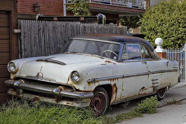
– photo by Mitch Waxman
Wandering around the forbidden northern coast of Queens one day, a humble narrator happened across another one of those historic vehicles which are referred to at this – your Newtown Pentacle – as “Cool Cars” in Astoria.
As far as I’ve been able to discern – and as always – if I’m wrong, please correct my assertion – this is El Producto de Ford – a 1954 Mercury Monterey.
from wikipedia
The Mercury Monterey is a full-size car model that was introduced by Mercury in 1952. It would later share the same body style with the slightly more upscale Marquis, and the Park Lane and Montclair until the latter two were extinguished after the 1968 model year.

– photo by Mitch Waxman
It’s obviously well weathered, that’s for sure. This auto was parked alongside a series of one car garages and spotted around a block from Astoria Blvd. There’s a lot of similarity in body type and flashing to the Mercury Monterey Sun Valley, but this coupe has a hard top metal roof rather than the translucent plastic which the Sun Valley was offered with.
The Monterey model was a full-size near-luxury car introduced in 1950 and was the most expensive and luxurious vehicle in Mercury’s lineup. At the time General Motors and the Chrysler Corporation were producing a number of ‘hardtop convertibles’ and Ford was determined not to stand idly by as GM and Chrysler dominated the market with its attractive new pillarless coupes.

– photo by Mitch Waxman
Check out that space age design on the grill. Back then, gasoline was cheap, and tacking half a ton of extra weight onto the front of a car for the sake of ornamentation was no big deal. If you’ve never driven a car from this era, I can tell you that they are beasts.

– photo by Mitch Waxman
Cars like this 1954 Mercury Monterey lay heavily into turns, squeal their wheels, and when you step on the gas – it’s no modern differential gear smoothly driving the train – you get pressed back into your seat by zero to thirty in 3.4 seconds type acceleration. There are no lap and shoulder belts to hold you snugly in place while it’s happening, either. This model was built with a Y block V8 engine, which offered the coupe some 161 HP worth of juice.
Vroooooom!
“follow” me on Twitter- @newtownpentacle
Upcoming Tours –
September 3rd, 2015
Newtown Creek Boat Tour
with Open House NY, click here for details and tickets.
September 20th, 2015
Glittering Realms Walking Tour
with Brooklyn Brainery, click here for details and tickets
twining tightly
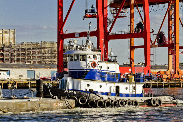
Tugboats, tugboats, tugboats – in today’s post.
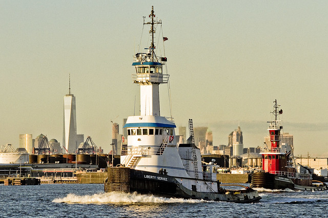
– photo by Mitch Waxman
A recent Working Harbor Committee excursion to Port Elizabeth Newark was particularly photogenic. We’ve entered into “that time of the year,” wherein the angle of the light emanating from the burning thermonuclear eye of God itself is propitious to photographic pursuit. From now until mid November, and again in the March to June period, the light is just right.
Pictured above are the Liberty Service and Marion Moran tugs at full steam on the Kill Van Kull.
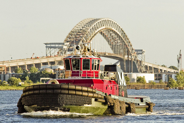
– photo by Mitch Waxman
Kirby Moran, which is a new boat for me, with the Bayonne Bridge as back drop, was observed over in Newark Bay.
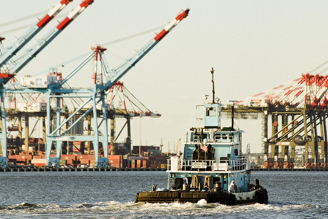
– photo by Mitch Waxman
DonJon Towing’s Emily Ann was headed north in Newark Bay, with the titanic Global Marine Terminal behind her.
– photo by Mitch Waxman
Not sure which tug this was, as I couldn’t spot a name or IMO number on her, but she was docked at Governor’s Island – on the south or Buttemilk Channel side, with some old French chick standing behind the barge she was tending.
– photo by Mitch Waxman
Speaking of Buttermilk Channel, Mary H. was towing a fuel barge past Atlantic Basin when I spotted her. I know where Mary H. was likely headed for – East Williamsburg’s Metropolitan Avenue – and the Bayside fuel depot found 3.1 miles from the East River on the English Kills tributary of my beloved Newtown Creek.
“follow” me on Twitter- @newtownpentacle
Upcoming Tours –
September 3rd, 2015
Newtown Creek Boat Tour
with Open House NY, click here for details and tickets.
obvious empiricism
Tomorrow – Calvary Cemetery awaits.

– photo by Mitch Waxman
At 11 a.m. tomorrow, I’ll be narrating (humbly) a walking tour of First Calvary Cemetery here in LIC’s Blissville neighborhood. I will be at the northeast corner of Greenpoint and Review Avenues at 10:30 a.m. As long time readers of this, your Newtown Pentacle, will tell you – I have a special love for Calvary.
It’s the largest chunk of “green infrastructure” found along the Newtown Creek as well as serving as the final resting place of literally millions of Roman Catholic New Yorkers. It’s part of the firmament of LIC, and a significant touchstone for the history of 19th century NYC.

– photo by Mitch Waxman
Expect to encounter unexpected life forms in Calvary. The cemetery lies along the migration routes of several bird species, and I’ve spotted everything from Canada Geese to Great Blue Herons and Red Tail Hawks there. On, and in, the ground there’s a plethora of critters – such as the small rabbits which the Irish of the 19th century would have referred to as “Coney’s.” No guarantee on what we will spot, but there’ll be something interesting.

– photo by Mitch Waxman
Sculptural monuments are found everywhere in First Calvary, from thirty foot high obelisks to enormous mausolea. We will be visiting the final resting place of Governors, Senators, even the tomb of the original gangster himself – Joseph Masseria. The rightful King of Ireland is buried in Calvary, along with members of Corcoran’s Legion – the Fighting 69th. For NYC history fans, and tapophiles – this place is a smorgasbord of interest.

– photo by Mitch Waxman
The walking tour will be roughly two hours long, and will range over several shallow hills which host a natural grass surface. A hat or parasol is highly recommended to shield yourself from the sun. The walk is not difficult, but if you suffer from mobility issues – this likely is not the tour for you. Surrounding Calvary Cemetery are the concrete devastations of Western Queens – and the heavy industrial zone which forms the northern shoreline of the Newtown Creek. We will have a unrivalled view of the ongoing Kosciuszko Bridge construction project, btw.

– photo by Mitch Waxman
Bring your camera along, as Calvary Cemetery is a jewel. The Manhattan skyline is omnipresent, providing for impossibly candid views of an area stretching from the Williamsburg Bridge to the Queensboro. During the era of the so called “Gangs of New York” there was a saying which went “All roads lead to Calvary” and the cemetery was once a major destination for the Catholic masses of tenement Manhattan. Surrounding the great burying ground were saloons and road houses that serviced mourners. After the tour concludes, we will be visiting the last of these road houses (bar and food not included in ticket price, btw, just a post tour hang out).
One other thing to mention, obviously, is that if there’s a funeral underway we are going to steer clear of it out of respect and deference for the mourners.

– photo by Mitch Waxman
Walk ups are always welcome, for those of you uncomfortable with online ticketing, and the cost of the tour is $25 per head. For those of you who are comfortable with such online things, the link found below will take you to a credit card processing page. As a note, I couldn’t make the “ships within two weeks” line go away on the cc processing page, which a couple of people mentioned as being confusing. Nothing will be shipped to you, but you will receive an email receipt and your name will appear on the check in list I’ll be using “day of.”
Hope to see you tomorrow morning, at the corner of Greenpoint and Review Avenue, at 11 a.m.
“follow” me on Twitter- @newtownpentacle
Upcoming Tours –
August 22nd, 2015
First Calvary Cemetery – LIC, Queens Walking Tour
click here for details and tickets.
September 3rd, 2015
Newtown Creek Boat Tour
with Open House NY, click here for details and tickets.
