Posts Tagged ‘Pittsburgh’
St. Stanislaus Kostka R. C. Church
Monday
– photo by Mitch Waxman
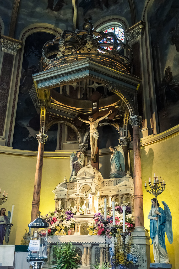
That’s the… what do you Goyem call it… altar? The stage? I don’t know, but it’s the centerpiece and point of focus at Pittsburgh’s St. Stanislaus Kostka Roman Catholic Church. My grandmother would have referred to the statuary depicting the crucified Christ rising above a scale model of Rome’s St. Peter’s Basilica at the Vatican simply as “Yuyzel on da cruss.” What can I tell you, I grew up Jewish.
I’ve visited this ‘sacred space’ before, but this time around I was on a walking tour of the surrounding strip district offered by the ‘Doors Open Pittsburgh’ outfit and I got to linger and take a really good look at the place.
– photo by Mitch Waxman
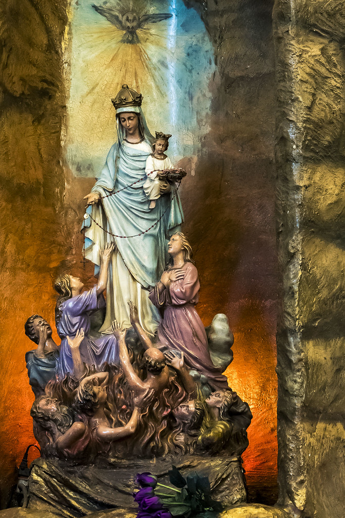
This sculpture caught my attention just because there’s so much going on in the composition. Whom I would presume to be Mary is holding a baby I would presume to be Jesus, and offering the Rosary to the damned. I’m sure that every hand posture and facial expression has some allegorical meaning, as that would be ‘very Catholic.’ It was located behind the rack of votive candles, if that means anything. It probably does.
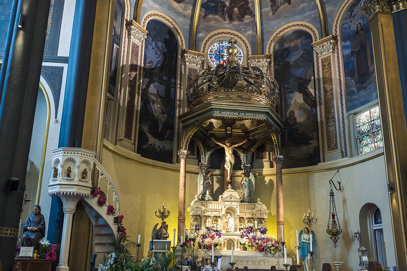
One of the Lay people who care for the church spoke to our group of lookie loos and detailed the history of the centuried congregation and it’s many trials that have included catastrophic floods and nearby industrial explosions. I couldn’t get a decent shot of the mural on the ceiling vault, which depicts John Sobieski and the boys arriving in Vienna to kick some Turk ass. For those not familiar with the battle, it’s what Tolkien based the ‘Charge of the Rohirim’ at Helms Deep on in his Lord of the Rings epic.
– photo by Mitch Waxman
On our way back out to the street, and we had to leave in an expeditious fashion as the Church’s Priest had appeared in vestment, with a large family in tow and they were preparing to christen a new baby. If you’re ever in Pittsburgh, definitely put this jewel of a church on you list to visit. Pope John Paul 2 did, so why not you?
As a note, I’ve actually done a bit of research on the ritual of Baptism in the past and it is positively ancient. The Canaanites were basically fire worshippers, being connected to the religions of the Phoenicians as they were – with Baal as the central godhead and ritual sites found on the hilltops in wilderness areas – so it’s unlikely that the proto Hebrews picked it up from them. Theoretically, Baptism became part of the portfolio about the same time that Angels first became part of the story, during the ‘Babylonian Captivity.’
Back tomorrow.
“follow” me on Twitter- @newtownpentacle
Buy a book!
“In the Shadows at Newtown Creek,” an 88 page softcover 8.5×11 magazine format photo book by Mitch Waxman, is now on sale at blurb.com for $30.
The very air
Friday
– photo by Mitch Waxman
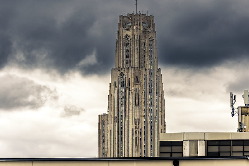
The light is very different here in Pittsburgh, with its river valley atmospherics, than the skies that I used to experience back in the oceanic climes of NYC. It’s been mentioned a few times here, the volatility and changeability of Pittsburgh’s weather. Apparently, it’s the interaction between the flat plains of Ohio and Pittsburgh’s location in the foothills of the Appalachian range, coupled with the corduroy riverine terrain which generates the dynamics above. It could be gray, then raining, then bright sun, and then overcast again all within a couple of hours.
Observationally, Pittsburgh’s specific location is one that causes most of the truly severe weather just blow around it (so, meteorological kudos to George Washington). 50 miles north or south, they’re getting blasted with snow or even tornadoes, and in Pittsburgh it’s just drizzling. I’ve apparently gotten lucky in terms of the move, as this year had a mild enough winter that the TV news meteorologist people have commented on it.
– photo by Mitch Waxman
Thing is, and you may have noticed this in the last few months, is that the sky here is a distinct part of the setting, so I’ve been making it a point of exposing the images in a manner designed to capture the circumstance. Back in NYC, if you wanted to ‘place’ an image it was just a matter of getting a landmark like the Empire State Building in it and no matter what the subject was, the visual subtext indicated ‘NYC.’
I’m working under the theory right now that Pittsburgh’s ‘Empire State Building’ which ‘sets the place’ is the sky itself, with its dynamic stacks of clouds and omnipresent turbulence. When we first moved here, one of the new neighbors advised that Vitamin D supplements would be advisable, given that on average – 2 out of every 3 days in the Pittsburgh region are at least partially overcast. The locals complain about experiencing ‘SAD’ or ‘Seasonal Affective Disorder’ due to a lack of radiate exposure to the burning thermonuclear eye of god itself, and that these supplements help vouchsafe one against the phenomena.

– photo by Mitch Waxman
In general, you’re a lot closer to the sky in this part of the country than you are down on the coastline. The first shot in today’s post depicts UPITT’S Cathedral of Learning in the Oakland section, the second is from the Strip District along the Allegheny River, and the one above was captured while onboard a boat navigating the Monongahela River during a period of fairly heavy rain.
In all three shots, what caught my eye was the sky vault itself, rather than the arrangements along the ground. I don’t know, maybe it’s my imagination. Is any of this real? Where am I? Maybe I’m on a ventilator somewhere and this is all just some fantasy that’s playing out while my brain is dying. Who can tell?
Back next week with more.
“follow” me on Twitter- @newtownpentacle
Buy a book!
“In the Shadows at Newtown Creek,” an 88 page softcover 8.5×11 magazine format photo book by Mitch Waxman, is now on sale at blurb.com for $30.
Whatever you do, don’t stop moving
Tuesday

– photo by Mitch Waxman
Dat’s what dey call’s da ‘Boulevard of the Allies,’ round these parts. Turns out that the pedestrian pathway leading to the Liberty Bridge which I’d been looking for is part of ‘it.’
There’s a regular ground level street with the same name found just west of this structure, but this approach span and the bridge itself represents nearly a half mile of steel and concrete that rises multiple stories up from the ground. This elevated section in particular is ‘mega massive.’ It cloverleafs with other high speed roads like ‘Crosstown Boulevard’ and they all feed southbound traffic first to the Liberty Bridge and then into the Liberty Tunnel, and or the P.J. McArdle roadway, on the south side of the Monongahela River.
Down under, that’s Pittsburgh’s Second Avenue.

– photo by Mitch Waxman
This is what that view looks like from Second Avenue. There’s an odd collection of buildings down here, including a homeless shelter and the City jail. There’s also a lot of Law Enforcement related stuff down here, lots of cops milling about, and signage suggests bail bondsman activity. The street is somewhat forbidding, and is populated by people who are obviously down on their luck. I guess that includes me, so there you go.
As it turned out the place where you could access that pedestrian walkway over the Liberty Bridge pictured above was found where the Boulevard of the Allies first becomes airborne, which is also more or less the titular end of Second Avenue.

– photo by Mitch Waxman
A humble narrator continued on his way, towards the other side of the river, but I was all excited by the points of view on offer.
As mentioned, this is one of the routes which I drive all the time getting to and from. HQ is about 5 or 6 miles away to the south, on the other side of Mount Washington in the Dormont section of the South Hills.

– photo by Mitch Waxman
That’s the Liberty Bridge. With the approaches, this 1928 steel cantilever bridge is 2,663 feet long and is said to carry some 63,000 vehicle trips a day. Like most of the bridges you encounter in this region, there’s a protected by concrete barrier pedestrian and bike path. What happens when you get off the bridge on the other side is a bit less thought out than you’d like, but there you are.
Scuttling on, ever forward, that’s me.

– photo by Mitch Waxman
That’s Pittsburgh’s Light Rail – the T – which has just left its First Avenue Station. The elevated track goes underground into an old freight train tunnel which has been converted for the T’s usage, nearby. Ultimately, its terminal stop is on the North Shore of the Allegheny River, which is where this particularly narrative choked walk began last week.
In real time, this was an afternoon. The photo opportunities were a bonus, as what I was engaged in was actually exercise related. The old program which used to be religiously obeyed in Queens is back. One day out for a couple of miles there and back, one day not, with some grandiose multi mile physical effort playing out on the weekend or whenever it’s possible. The particular walk being described in these posts isn’t one of the grandiose ones, rather it’s a short one.

– photo by Mitch Waxman
One of the things which made Pittsburgh attractive was the quality of its healthcare space. The post industrial recovery plan which they’ve been following here for a few decades is referred to as ‘eds and meds.’ ‘Eds’ refers to the universities and research spheres, and ‘meds’ to a saturation of hospitals and healthcare outfits found here. Doctor appointments in Pittsburgh are a completely different banana than they are in NYC. The docs don’t have to book seven patients an hour in order to cover the rent.
Since moving here, and particularly after describing Newtown Creek to the doc, lots of tests got ordered. I’ve been poked, prodded, sampled, and scanned in the name of creating a baseline to judge my future degradation and dissolution against. Last Friday, while drinking my morning coffee, an alert came in that results from one of the recent irradiations had revealed that I haven’t got Lung Cancer. Yay.
Tomorrow – the shots I was after on this walk.
“follow” me on Twitter- @newtownpentacle
Buy a book!
“In the Shadows at Newtown Creek,” an 88 page softcover 8.5×11 magazine format photo book by Mitch Waxman, is now on sale at blurb.com for $30.
Give me Liberty, you can keep the death
Monday

– photo by Mitch Waxman
As described last week, one recently embarked on an afternoon constitutional walk. A ride on Pittsburgh’s Light Rail service arrived me to the north side of the Allegheny River, whereupon a short scuttle found me crossing one of the ‘3 sisters’ bridges, heading south to a crossing of the Monongahela River using the Liberty Bridge.
‘Photowalk’ as I use the term involves moving through an urban space you’re fairly ignorant about, while noticing literally everything with a camera in my hand, and using little more than street smarts and a vague sense of direction as a guide. That’s how you blunder across things, and find out why some things are found where they are.

– photo by Mitch Waxman
Downtown Pittsburgh is how I think you’d describe the area I was moving through. Big Corporate, and Governmental, offices that are set back from the street by parklets – the whole Le Corbusier thing. The sidewalks are wide. When you want to cross a street, you are meant to push a big button on the utility pole which plays you recorded messages that instruct you when it’s safe to cross. Traffic moves pretty quickly around here. Downtown looks like ‘the Future,’ if you were imagining the 21st century back in 1983.
Hey, I’m a well known anti-fan of a lot of modern buildings. I had a less than stellar reaction to Hudson Yards, as you might recall.

– photo by Mitch Waxman
I believe that the Romanesque fortress pictured above is part of some sort of court house, but that’s only if I believe the signage posted at its entrances. That is some serious Batman/Gotham City shit going on right there. They did, in fact, shoot one of the Dark Knight movies here in Pittsburgh.
Having crossed an admittedly flat and easy to walk section of Pittsburgh’s triangular shaped business district, reliance on the innate sense of direction carried me to the surprisingly long Liberty Bridge for my crossing of the Monongahela River.

– photo by Mitch Waxman
While walking up what turned out to be a dead end pathway towards where I thought the pedestrian path of the Liberty Bridge began (wherein that innate sense of direction I’m so proud of betrayed me and sent me into a hazardous circumstance), I encountered this amazing bit of engineering and spatial accommodation. This parking lot was built into every single available inch of space around the supports of the bridge. Wow.
So, I found myself having walked up the wrong path, which was basically an actual highway onramp. Yikes.

– photo by Mitch Waxman
Apparently there used to be a pedestrian path here, once, long ago. It’s also clearly closed off. I drive over this bridge all the time, and what I’d seen while doing so had piqued my attentions. A humble narrator would not be defeated by mere geography!
No reason not to get a photo of it from this point, though.

– photo by Mitch Waxman
I scuttled past of few down on their luck types who were standing alongside the ramp with signage describing their various plights which adjured passing vehicular strangers to render aid onto the sign wielder. One of these fellows had just stepped out of a fence hole, leading to a parking lot, a path which – once followed in reverse – allowed me to lope and scuttle back down to a regular sidewalk.
More tomorrow.
“follow” me on Twitter- @newtownpentacle
Buy a book!
“In the Shadows at Newtown Creek,” an 88 page softcover 8.5×11 magazine format photo book by Mitch Waxman, is now on sale at blurb.com for $30.
Under the on and off
Friday

– photo by Mitch Waxman
I know, I’m obsessed. To be fair, though, I’ve been showing you all pictures of highway and expressway ramps for better than a decade now. LIE, BQE, Grand Central etc., all back in NYC. I’ve got new ones to puzzle over now.
Once I walked past the interchange pictured above, on a more or less eastward path, the entire streetscape suddenly altered. As mentioned yesterday, these highway on and off ramps are serving many masters. Interstates, local roads, even the approaches leading to bridges and tunnels – all were set into long arcing shapes suspended above the ground. There had to be a spot where the overflying concrete and steel occluded the burning thermonuclear eye of god itself and supernal darkness could be found.

– photo by Mitch Waxman
There’s a few blocks of ‘forever shadows,’ which are used as parking lots, but this might be a great place to grow mushrooms too. There’s private parking spaces associated with this business or that hotel, but it seemed that most of the space down here was of the ‘park all day’ type. Of course, the Steelers stadium was behind me and the Pirates stadium lay ahead, so yeah – you’d need a serious inventory of lot parking in a sports town like Pittsburgh.
Truth be told, I was kind of expecting to see homeless encampments down here, or at least some sort of messy condition reminiscent of what I saw under the BQE in North Brooklyn back at the start of 2022. Nope. Barely even any graffiti.

– photo by Mitch Waxman
Scuttling along towards my eventual crossing of the Allegheny River, which would bring me onto the so called ‘Golden Triangle,’ which forms the city of Pittsburgh’s corporate and political center. From there, my planned route would carry me to a crossing of the Monongahela River to the south. There’s a local street moving at ground level between the ramps, one which I’ve driven down a few times and can’t really recommend.
That’s another post, for another day, however. Back next week with more from Pittsburgh at this – your Newtown Pentacle.
“follow” me on Twitter- @newtownpentacle
Buy a book!
“In the Shadows at Newtown Creek,” an 88 page softcover 8.5×11 magazine format photo book by Mitch Waxman, is now on sale at blurb.com for $30.


