Posts Tagged ‘railroad’
graceful valleys

– photo by Mitch Waxman
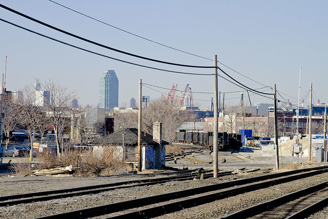
A structure which may be discerned in the distance, within the shot above, at Sunnyside Yards is the 35th street or Honeywell Bridge. The location of the camera which captured it was astride the 39th street or Harold Avenue bridge at Steinway Street, where ongoing construction has rendered a hidden breach in the fencing which normally frustrates its purpose by obfuscating the view.
For a discussion of another of the bridges which cross these titan rail yards, click here for the posting “incaculable profusion”, examining the Thomson Avenue Viaduct to the west.
from forgotten-ny.com
When the Yards were built, Long Island City, to the north of the Yards, was effectively cut off from Sunnyside and Maspeth, to the south. Viaducts were built at Queens Boulevard (which was itself under construction in 1910), Honeywell Street, Harold Avenue, and Thomson Avenue. Laurel Hill Avenue (43rd Street) Gosman Avenue (48th Street) and Woodside Avenue were carried under the railroad.

– photo by Mitch Waxman
A paucity of such apertures in the fence lines around the yards exists, which is appropriate in this age of heightened vigilance, and the discovery of something large enough to accept the lens of a dslr is tantamount to observing a unicorn to one such as myself. Of course in the midst of all this faux security and theater, I can show you a dozen different places where you could work mischief if you chose to. Such is always the case with large installations like this one, however, and illegal trespass is not the Newtown Pentacle way.
The real estate happy characters in Manhattan are desirous to rob me of this vista, as evidenced in the document linked to below, describing the feasibility and benefits of decking over these yards and expanding the population of western Queens by tens of thousands. It seems to be a plan of some vintage, however, crafted before the financial crisis and concurrent economic crisis experienced by the region and country at large since 2008 (when do we get to start calling this a depression?).
from nyc.gov
Sunnyside Yards, one and three-quarters of a mile long and 1,600 feet across at its widest point, is the largest site in this inventory. The total deckable airspace of its 14 parcels – over 167 acres – is more than double the size of the next largest airspace site, the 74-acre NYCT Coney Island Maintenance Shop and Yards (K5000). This one corridor contains around one-sixth of the entire deckable airspace in this inventory.
The potential for large scale land uses above these yards is extraordinary. With the possible exception of Staten Island’s west shore, no other large tracts of “vacant” land remain in the City. Moreover, Sunnyside Yards is defined by a surrounding context of relatively dense development and plentiful transit access.
At the behest of former Deputy Mayor for Economic Development and Rebuilding Daniel Doctoroff, DCP’s Housing, Economic and Infrastructure Planning (HEIP) unit conducted a preliminary analysis concerning the viability of decking over and developing Sunnyside Yards. The HEIP unit determined that the most desirable sites within the yards were two roughly rectangular areas running from the southwest to the northeast; the northern third of both sites is located northeast of Queens Boulevard.

– photo by Mitch Waxman
These trusses which fly over the Sunnyside Yards are actually rather new. The Honeywell and Harold Bridges (39th and 35th streets), for instance, were totally rebuilt recently. The Honeywell Bridge reopened in 2003 after having laid fallow and closed to pedestrian and vehicle traffic for better than 20 years. The night shot above, by the way, is betrayed by its format and shape as being from my trusty old Canon G10, which is still in service at this- your Newtown Pentacle.
from nytimes.com
In 1979, inspectors from the city’s Department of Transportation judged the 1,600-foot four-lane bridge, which was built in 1909, to be on the verge of falling down. The inspection occurred near the end of an era in which the city, nearly broke and as exhausted as a disco dancer at dawn, partly balanced its budget by deferring maintenance on bridges. Tom Cocola, a department spokesman, said once costs had been cut by removing the bridge from the city’s regular inspection schedule, ”we probably just forgot about it.”
proper turns
– photo by Mitch Waxman
Once upon a time, this wasn’t the proverbial “wrong side of the tracks”, rather this was the center of town. 18th century residents would ask “what on earth could have happened to Maspeth Creek” were they able, and “where is the Town Dock which DeWitt Clinton himself used- where is it”?
What happened?

– photo by Mitch Waxman
19th Century residents and passerby would inquire what disaster occurred, that Haberman’s and Nichols Chemical and all of Berlin and Blissville have disappeared and been forgotten? What has happened to the great factories, the mills, and the hustle and bustle? Where have all the railroads gone, can one paltry freight line actually be charged with servicing all of Newtown Creek?

– photo by Mitch Waxman
For your humble narrator, a good place to ponder this sort of question has always been the Clinton Diner.
This little oasis has hosted a full group from a bus tour I helped conduct, acts a central meeting point for all sorts of Newtown Creek functions, and has provided a much needed cup of coffee and clean rest room to a half frozen yet quite humble narrator on more than one occasion.
It’s also sitting pretty much on a shoreline that Maspeth Creek once flowed past.

– photo by Mitch Waxman
Accordingly, a “Happy Valentine’s” day shout out to the Clinton Diner is offered today.
It would be meaningless to offer you shots of its interior as it has been featured more than once in the cinema. Witness below the trademark dolly shot of Martin Scorcese in Goodfellas… The window booth that DeNiro and Liotta are sitting in is the one with the “Go Giants” signage in the shot above.
And a happy valentine’s day greeting is offered to you as well, lords and ladies… or a giddy Lupercalia.
The Clinton Diner is found at 5626 Maspeth Ave., Maspeth, NY 11378-2248 (718) 894-3475
unutterable and unnatural

– photo by Mitch Waxman
Haunting the bridges which carry pedestrian and vehicular traffic over the Sunnyside yards, as always, your humble narrator is both frustrated and relieved at the presence of the stout steel plating which obscures the track.
Frustrated, because it makes it quite difficult to photograph and bear witness to its wonders- Relieved because the vital infrastructure of the rail yard is protected from casual “sapping”.
I, of course, know where every gap in the fencing exists that is large enough to poke a camera lens through.

– photo by Mitch Waxman
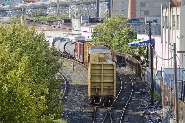
The Yards are used not just by it’s main tenants- Amtrak and the Long Island Railroad- it also serves as temporary housing for the excess capacity of other area rail lines, such as the New Jersey Transit cars on the left hand side of the shot above. The ones on the right are Amtrak.
In the distance is that assemblage of early 20th century industrial splendor known as the Degnon Terminal.

– photo by Mitch Waxman
The amazing layer cake of Western Queens is manifest in this place, where the drained swamp which became the Sunnyside Yards reveals the natural grade of the land. The tracks of the 7 Subway line hang over a viaduct which exits Queens Plaza and becomes Queens Blvd.
In the distance are the former Ever Ready Battery, American Chicle, and Sunshine Biscuits “Thousand Windows” factories which were the crown jewels of the Degnon Terminal.
corporeal presence

– photo by Mitch Waxman
Presented today are a few shots of a very common occurrence presented from a fairly uncommon point of view. The Amtrak train above is traveling down the Hudson toward Manhattan, approaching the Spuyten Duyvil bridge, and the vantage point is onboard a small boat bobbing around in the river.
From Wikipedia
The Spuyten Duyvil Bridge is a swing bridge that carries Amtrak’s Empire Corridor line across the Spuyten Duyvil Creek between Manhattan and the Bronx, in New York City. The bridge is located at the northern tip of Manhattan where the Spuyten Duyvil Creek meets the Hudson River, approximately 1,000 feet (300 m) to the west of the Henry Hudson Bridge. It was built to carry two tracks, but now carries only a single track on the east side of the bridge.
A wooden railroad bridge across the Spuyten Duyvil was first constructed by the New York & Hudson River Railroad in 1849. The current steel bridge was designed by Robert Giles and constructed in 1900; the piers rest on pile foundations in the riverbed. Trains stopped running across the bridge in 1982 and the following year the bridge was damaged by a vessel and left stuck in the open position.

– photo by Mitch Waxman
Amtrak runs a passenger line down the Hudson River which occupies a historic corridor of tracks. As is Newtown Pentacle policy on the subject, your humble narrator freely admits to “don’t know much more than squat” status about the rail system, but the Spuyten Duyvil bridge seems to have suffered a lot of bad luck over the years.
From Wikipedia
Spuyten Duyvil Creek (pronounced /ˈspaɪtən ˈdaɪvəl/) is a channel connecting the Hudson River to the Harlem River Ship Canal, and on to the Harlem River in New York City, separating the island of Manhattan from the Bronx and the rest of the mainland. The neighborhood named Spuyten Duyvil lies to the north of the creek.
Spuyten Duyvil Creek originally flowed north of Manhattan’s Marble Hill. The construction of the Harlem River Ship Canal to the south of the neighborhood in 1895 turned Marble Hill into an island, and in 1914, when the original creekbed was filled in, Marble Hill became physically attached to the Bronx, though it remains part of the borough of Manhattan.
Another realignment of the creek occurred in the 1930s, to the west of the original realignment. This had the opposite effect: It separated a portion of the Bronx and resulted in its attachment to Manhattan as a small peninsula where the Inwood Hill Park Nature Center is now situated.
“Spuyten Duyvil” literally means “Devil’s Spout” or Spuitende Duivel in Dutch; a reference to the strong and wild currents found at that location.

– photo by Mitch Waxman
Several times have I encountered the rumors that these tracks are haunted, in both modern and historical accounts. A long history of tragedy, including a ghoulish 1882 collision, seems to be associated with this place. Fires, maritime and vehicular accidents, pedestrians crossing the tracks being struck, even the weather has nearly done this bridge in more than once. There were sightings of spectral locomotives in the 19th century along this stretch (and all up and down the tracks between here and Albany as well).
There has been much speculation concerning the origin of the name “Spuyten Duyvil.” Dutch in origin, Spuyten Duyvil can be translated in two ways, depending on the pronunciation. One translation is “Devil’s whirlpool,” and indeed, sections of the creek were sometimes turbulent during high tide. The second interpretation is “to spite the Devil.” This translation was popularized by Washington Irving’s story in which a Dutch trumpeter vowed to swim across the turbulent creek during the British attack on New Amsterdam “en spijt den Duyvil (in spite of the Devil).”

– photo by Mitch Waxman
Practical, private, and stern- the iron visage of the laborers who captain these locomotives do not discuss such frivolous subjects with outsiders, and instead focus on craft and profession. It is a sad thing to see the rich folklore of the rails fade away from the American mind, since these were once the miracle machines of “progress”.
You don’t hear kids talking about “John Henry” or “Casey Jones” anymore, for instance, or threaten their parents with jumping onto a passing train and living life as a “Hobo“.
From Wikipedia
The National Railroad Passenger Corporation, doing business as Amtrak (reporting mark AMTK), is a government-owned corporation that was organized on May 1, 1971, to provide intercity passenger train service in the United States. “Amtrak” is a portmanteau of the words “America” and “track”.It is headquartered at Union Station in Washington, D.C.
All of Amtrak’s preferred stock is owned by the U.S. federal government. The members of its board of directors are appointed by the President of the United States and are subject to confirmation by the United States Senate. Common stock was issued in 1971 to railroads that contributed capital and equipment; these shares convey almost no benefits but their current holders declined a 2002 buy-out offer by Amtrak.

– photo by Mitch Waxman
Folkloric to the generations of the latter 19th century, rail offers up some of the greatest stories. Here’s a couple:
Express Train to Hell, Lincoln Death Train.
From Wikipedia
With primarily passenger services, the Northeast Corridor is a cooperative venture between Amtrak and various state agencies. Amtrak owns the track between Washington and New Rochelle, New York, a northern suburb of New York City. The segment from New Rochelle to New Haven is owned by the states of New York and Connecticut; Metro-North Railroad commuter trains operate on this segment. North of New Haven, ownership again reverts to Amtrak, whose tracks stretch to the border between Rhode Island and Massachusetts. The final segment from the border north to Boston is owned by the Commonwealth of Massachusetts.
Under Amtrak’s ownership, the Northeast Corridor suffered from several high-profile electric-power failures in 2006 and other infrastructure problems. Intermittent power outages caused delays of up to five hours for Amtrak and commuter trains. Railroad officials have blamed Amtrak’s funding woes for the deterioration of the track and power supply infrastructure, which in places is almost a hundred years old.
Amtrak owns Pennsylvania Station in New York, 30th Street Station in Philadelphia, Pennsylvania Station in Baltimore, and Union Station in Washington.

– photo by Mitch Waxman
Passenger service is remarkably unexciting, of course, what you want to see are long chains of variegated freight cars hauling lumber and coal and who know what else beneath a stretching trail of steam and smoke painted across the sky. Unfortunately, New York isn’t in that kind of business anymore.
From Wikipedia
The tale of how Spuyten Duyvil got its name is said to be that Peter Stuyvesant, then Governor of New Amsterdam, got wind that the British Navy was going to invade the city. He dispatched Anthony Van Corlaer, to ride up to the northernmost point of Manhattan Island and blow his trumpet, a common means of summoning the people. As he neared the shores where the Hudson meets the Harlem River, Van Corlaer couldn’t cross. It was a stormy evening when he arrived at the upper end of the island, and as no ferryman was available he vowed to swim across the river “in spite of the devil” (Dutch: “in spuyt den duyvil”). Halfway across, legend has it that the devil pulled Van Corlaer under, and while he was able to escape his grasp, he was too tired to continue swimming and drowned there despite his escape. From then on, the little area in the Bronx where Van Corlaer would have come to shore is called Spuyten Duyvil.

– photo by Mitch Waxman
This is the first of several postings detailing certain sites and scenes which were observed along the Hudson, Harlem, and East Rivers on a brisk Saturday in the month of November. The small boat I was on is operated by the good folks at Riverkeeper and a hearty thanks is sent for both their good work and for allowing me to ride along on one of their regular patrols.
From Wikipedia
The P32AC-DM locomotive was developed for both Amtrak and Metro-North so it can operate on power generated either by the on-board diesel prime mover or a third rail electrification system at 750 volts direct current. The P32AC-DM is rated at 3,200 horsepower (2,390 kW), 2,900 horsepower (2,160 kW) when supplying HEP, and is geared for a maximum speed of 110 mph (177 km/h)
The Dual Mode P32AC-DM is unique not only because of its third-rail capability, but also because it is equipped with GE’s GEB15 AC (alternating current) traction motors, rather than DC (direct current) motors as used in the other subtypes. The type is confined to services operating from New York City, where diesel emissions through its two fully enclosed main terminals are prohibited. The P32AC-DM are seen only on Amtrak’s Empire Corridor between Penn Station and Buffalo, the Ethan Allen Express, Lake Shore Limited (New York section), Adirondack, and Maple Leaf services, and locomotive-hauled Metro-North Railroad commuter trains to and from Grand Central Terminal. Metro-North Railroad Genesis locomotives have an escape hatch in the nose.
The Amtrak model third-rail shoes are for use on the over-running third-rail in Pennsylvania Station and the Metro-North Model are for under-running third-rail in Grand Central Terminal.

– photo by Mitch Waxman
A proper historical workup of the bridge, with the patented Newtown Pentacle multi view technology in place, will be forthcoming at some point in the future. You’d be doing your inner geek a disservice by not clicking on the diagram rich PDF linked to below.
an in depth analysis of this bridge (with diagrams, plans, and detailed engineering), and the herculean task of maintaining it, can be found in this 2004 PDF at arema.org
The bridge was originally constructed in 1899 by the King Bridge Company for the New York Central Railroad, and served for many years as a key link for freight delivery by rail to the west side of New Y ork City’ s main borough of Manhattan. Freight rail service to Manhattan dwindled in the years after World War II, but continued through the takeover of the line by Conrail in the 1970s, and into the 1980s. In the 1980s, Conrail discontinued all service on the line. Amtrak acquired rights to the line and initiated a program to start passenger service on the line.
quite convinced
– photo by Mitch Waxman
Recent financial setbacks and personal problems infect your humble narrator with a form of deep melancholy and a vast ennui. When such moments come upon me, there is a certain pizzeria in Greenpoint (Norman corner of Manhattan, near the train) whose offerings can be summed up best as: an actual and old fashioned “Brooklyn Slice”. On the day I spied this collection of rail cars at the so called “Bliss Tower” in DUGABO, I had scuttled forth from the rolling hillocks of my beloved Astoria in pursuit of one of these aforementioned slices, in an effort designed to brighten my mood.

– photo by Mitch Waxman
Errors and omissions mar my record when discussing the Rails, much to the chagrin of the knowledgable railfan community (whose helpful comments and corrections are always appreciated here at Newtown Pentacle). As such, what I can categorically tell you is that this a New York & Atlantic Locomotive, one of the 11 engine units which service the 269 miles of track operated upon by the Glendale based company in Brooklyn, Queens, and both Nassau and Suffolk counties. It shares much of its road with the passenger based Long Island Railroad, and NY&A’s distinctive emerald, white, and black engines are regularly observed around the Newtown Creek.

– photo by Mitch Waxman
Across the Newtown Creek Watershed, one encounters a landscape built for rail. Long abandoned track beds lie buried in inches of road asphalt, pointing the way to industrial giants long absent. Train stops orphaned from their purpose, spars and switches which were rudely severed to make room for modernity. All of it operated at street grade, and the remnants of the iron road are often the only tangible remains of great concerns and financial largesse. If you follow the right spar, you’ll discover that the NYPD Barricades unit was once Thypin Steel, or that LaGuardia Community College was once the Loose Wiles bakery and part of the Degnon Terminal.

– photo by Mitch Waxman
Within the communities which surround the Newtown Creek, a complaint often repeated concerns the presence of large numbers of trucks utilizing local streets in their quest to move goods from A to B. I had the privilege last year of attending a presentation by certain factions within the Port Authority that described a proposal which would eliminate several thousand truck trips a day throughout the City and over the George Washington Bridge, simply by shipping New York City’s garbage out to land fill utilizing locomotive rather than automotive means. Calculations about air pollution, road maintenance costs, and vehicular accident rates were presented at the time which compared rail quite favorably with truck based shipping.There was a maritime component to the plan as well, which was a bit hazy, but the train concept was spun gold.

– photo by Mitch Waxman
The shot above represents an NY&A Locomotive making a drop off of a customer in Maspeth near the ill fated St. Saviour’s church site, where they will uncouple a car or two for the unloading or loading of certain cargo. An unthinkable amount of trucks would be required to carry the same tonnage. The subject of Green Technology and “Greening New York” is often bandied about by many these days. Too much of the conversation, however, is “cocktail party environmentalism”- which sounds great but just isn’t practical on a policy level.
I’ve developed this funny notion, however, that the way forward is actually to re-imagine and re-invent the heaviest industry of them all.

– photo by Mitch Waxman
Rail infrastructure is what made Long Island City the factory of not just New York, but the entire world at the turn of the last century and multiple generations of capitalists and real estate interests founded vast fortunes because of the initial investment in it. Newtown Creek was the busiest waterway in North America, carrying more ship and barge traffic than the entire Mississippi for a time, and all of that maritime activity was fed by rail. Intermodal rail floats actually carried whole trains across the harbor to Manhattan, Staten Island, New Jersey and beyond. Imagine the benefits, in both individual wealth and environmental health, were we to try and save the future by looking for solutions in the past.
I’m still kind of forming this idea up for myself, but the key to it is containerization. More on this soon.
What do you, lords and ladies, think on the subject? Use the comments “Reply box” below, if you would like to start a conversation about it.


