Posts Tagged ‘Staten Island’
Bodiless, luminous, rejuvenated

– photo by Mitch Waxman
It’s what the gulls say.
As described in earlier posts, my mother has been ill, which has necessitated travel to and from… Staten Island… on the part of your humble narrator to safeguard her interests. I won’t bore you with the horrible realities of geriatric care in the City of Greater New York, but will instead share the way that I’ve passed the time while traveling back and forth from Astoria to… Staten Island.
Luckily, a fairly straight forward course exists, the R line connects western Queens with Manhattan, and its last stop in the Shining City is South Ferry- where the Staten Island Ferry docks at the Whitehall Terminal.
from nyc.gov
The following New York City Department of Transportation (NYCDOT) Staten Island Ferry Passenger Rules of Conduct shall be adhered to by all passengers to ensure the safety of the public and all employees.
1. No disorderly conduct or behavior that may be deemed unsafe or disruptive.
2. No littering. Place all trash and garbage in the receptacles provided.
3. No spitting or creating of any other unsanitary condition.
4. Lying down on seats and benches within the terminals and vessels is prohibited.
5. Feeding of any animal within the ferry terminals or on any vessel is prohibited.
6. Smoking is prohibited onboard the vessels and within all enclosed spaces in the terminals. Smoking is allowed only in designated open areas.
7. Distribution or posting of any literature or advertisements without a NYCDOT permit is prohibited.
8. Unauthorized carrying of a firearm or weapon within the terminals or on the ferries is prohibited.
9. No person shall skateboard, roller skate or ride a bicycle, scooter or any other vehicle or device (except a wheelchair required for transit) on or through any part of the terminals or ferries. Bicycles and non-motorized scooters must be walked through the terminals and ferries and board the vessel via the lower level.
10. Commercial use of video, photography or audio recording equipment without a NYC permit is prohibited.
11. Playing any audible device without the use of earphones is prohibited. Audible devices include but are not limited to radios, game devices and video/audio playback devices.
12. Pets, other than service animals as defined by the Americans with Disabilities Act, are not allowed in the facilities and/or onboard the ferry boats, unless they are caged and/or muzzled.
13. Destruction, graffiti, or marking of any facility or vessel is prohibited.
14. During an emergency all passengers shall follow the direction of NYCDOT facility personnel or vessel crew members.

– photo by Mitch Waxman
The short trip across NY Harbor passes the Narrows and the nearby Kill Van Kull which provide ocean going craft with a pathway to the titanic facilities of Port Elizabeth Newark. On the Staten Island side, the Ferry docks into the St. George terminal.
A vast industry is at work on the water though, wholly visible in the weird and dynamic lighting generated by that queer luminance filtering through the humid valences which typically occlude the burning thermonuclear eye of god itself during seasonal transitions from winter to spring here in the City of New York.
from wikipedia
The St. George Ferry Terminal is one of two terminals of the Staten Island Ferry with the other being South Ferry which is located on the southern tip of Manhattan near Battery Park. The Staten Island Ferry runs 24 hour service between both terminals.
Staten Island Ferry terminal at South Ferry in Lower Manhattan
Today the Staten Island Ferry annually carries over 19 million passengers on a 5.2 mile (8.4 km) run that takes approximately 25 minutes each way. Service is provided 24 hours a day, every day. Each day approximately five boats transport about 75,000 passengers during 104 boat trips. Over 33,000 trips are made annually.
During rush hours, ferries usually run every 15 and 20 minute intervals, decreasing to 30 minutes during the mid-days and evenings. During very late or early morning hours (the midnight hours) a ferry is provided once every 60 minutes. During the weekends ferries run every 30 and 60 minutes. In November 2006, additional ferries running every 30 minutes were provided during the weekend morning hours – the most significant change in the ferry schedule for about 3 decades.

– photo by Mitch Waxman
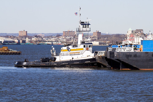
The Staten Island Ferry moves at a good speed, generating airborne turbulence that attracts avian opportunists. Floating in the boreal slipstream of the great ship, gulls and other harbor entities accompany weary citizens on their cross harbor commute. The commuters entertain themselves with magazines, newspapers, and gadgets while out on the water- where a 24 hour heavy industrial work schedule is maintained. Pictured above are the tugs Frederick E. Bouchard and Linda Moran.
From his first voyage at eleven years of age as a cabin boy on a sailing ship bound for China, Captain Fred Bouchard knew that shipping would be his life. By 1915, he was the youngest tugboat captain in the Port of New York.
NY Times Article from June 8, 1900
Woman and Child Saved (by Captain Bouchard)
On July 30, 1916, while on watch of the tug C. GALLAGHER of the Goodwin, Gallagher Sand Co., Captain Bouchard witnessed the infamous Black Tom Explosion, which detonated $22 Million dollars worth of WW I munitions. Always one to set out to accomplish what few others could, he took his tug from the Long Dock at Erie Basin in Brooklyn and headed for New Jersey. Amongst continuing explosions, which blew the glass panes and lights out of his tug, he worked to rescue the 4,000-ton Brazilian steamer TIJOCA RIO, and the schooner GEORGE W. ELEZY, of Bath, ME. Later the US District Court awarded the Captain a salvage award and an additional award for personal bravery, which totaled $9,000. He quickly invested the salvage award to create his own company, Bouchard Transportation Company, which was incorporated in 1918.

– photo by Mitch Waxman
The enormous orange car carrier cargo ship is being guided by the Miriam Moran, a 3,000 hp tug. The cargo ship, Tancred, is operated by the Wallenius Wilhelmsen company, and is just the latest ship of the historic Norwegian-America Line to bear that name. Maritime nomenclature refers to Tancred as a RORO- or Roll on and Roll off cargo ship.
from theshipslist.com
The company Wilh. Wilhelmsen was founded in Tønsberg in 1861 by Morten Wilhelm Wilhelmsen as a brokering and ship chandlering company and eventually became the largest Norwegian shipping company. In 1865 he entered shipowning when he purchased a share in the barque MATHILDE. The company’s first steamship, the TALABOT was purchased in 1887.
In 1901 the company progressed into liner services and in 1911 in partnership with Fearnley & Eger, established the Norwegian Africa and Australia Line. At the same time, the two companies took over the Norway Mexico Gulf Line.
By 1914 The Straits, China and Japan were added to the schedule and by this time the company was trading world wide. Although mainly a cargo company, many of their ships had accommodation for up to 12 passengers. In 1913 the company acquired it’s first oil tanker and by 1918 owned ten of these ships and had moved their operations to Oslo. In the inter war years, the liner trade was greatly expanded and the tankers and tramp ships gradually sold.
In 1920 Wilhelmsen took over the sole management of the Norwegian Africa and Australia Line and the Norway Mexico Gulf Line. In World War two, 26 of the company’s ships were lost, but were rapidly replaced after the war.
In 1969, Wilhelmsen, Fearnley & Eger and A. F. Klaveness jointly established Barber Lines. Later Wilhelmsens took over ownership and in 1975 established Barber Blue Sea Line jointly with Brostroms and Blue Funnel Line of Liverpool. In the 1970s, the company diversified into the offshore oil industry but sold their interests in this activity in 1995. The same year, Wilhelmsen’s acquired the Norway America Line. In 1999, The company formed a joint company with Wallenius of Sweden to operate both companies under the name of Wallenius Wilhelmsen Lines and still trades today.

– photo by Mitch Waxman
Tancred is capable of transporting thousands of automobiles in one ocean going structure. It was built at the Sumitomo Heavy Industries shipyard in Japan in 1987, has a gross tonnage (fully loaded) of 48,676, and is some 195.05 meters long. That’s 639.927822 feet, roughly one eighth of a mile. The fact that Tancred is riding so high in the water suggests that it has disgorged its cargo at the nearby Port of Newark.
from wilhelmsen.com
The PCTC (Pure Car and Truck Carrier) MV Tancred is one of three vessels built by Sumitomo Heavy Industries, Japan and she was delivered in April 1987. The vessel is specially suited for cars and trucks but she has also flexibility to carry other project cargo. MV Tancred has a total capacity of 5930 cars (RT43) or 552 trucks. Her sisterships are MV Tai Shan and MV Takara. The ship is built to the class of DNV (Det Norske Veritas) with the following designations DNV +1A1, Car Carrier MCDK, PET EO.

– photo by Mitch Waxman
Miriam Moran, of course, is operated by Moran Towing and was built at the McDermott Shipyard in LA in 1979.
from fundinguniverse.com
The Moran Towing Corporation, Inc. is the largest privately owned tugboat company operating on the East Coast of the United States and a leader in oil and dry-bulk barge transportation. A family-owned business for more than a century, the company was purchased in 1994 by a group of investors headed by Paul R. Tregurtha and James R. Baker, who were also principals in the Mormac Marine Group and the Interlake Steamship Company.
Although it was incorporated in 1905, Moran Towing traces its origins to 1855, when Michael Moran, a 22-year-old immigrant from Ireland, used money he saved as a muleskinner on the Erie Canal to buy a barge. Five years later, after acquiring several more barges, Moran headed to New York City, where he set himself up as a tugboat agent. In 1863, he paid $2,700 for half interest in the Ida Miller, a 42-ton, steam-driven harbor towboat.
By the 1880s, Moran Towing was an established company serving the busy New York Harbor, and in 1883, Michael Moran was asked to serve as commodore of the tugboat division for the 1883 ship parade celebrating the centennial of the British evacuation during the Revolutionary War. After the parade, Michael Moran continued to use the title “Commodore.” His son, Eugene F. Moran Sr., then 11 years old, recalled in Tugboat: The Moran Story, “Nothing, since he established himself in New York, gave him a greater sense of accomplishment than the name of commodore…. He had become a personality among seafaring men.” Almost 70 years later, The New Yorker would describe Michael Moran as a “bold but pious” man who “often found it necessary to use a fleshly approach in refining the general spirit. Upon finding a couple of his subordinates drunk and brawling, he would seize them and start banging their heads together, meanwhile crying out admonitions mixed with Scripture.”
Michael Moran also started the company tradition of naming tugboats after family members in 1881, when he christened the Maggie Moran, the first tug built for Moran Towing, for his first wife, Margaret. About the same time, he began the tradition of painting a block letter “M” in white on the black smokestacks of his tugboats.
When Moran Towing was incorporated in 1905, Michael Moran, then 73, was president of the company, and Eugene Sr., then 33, was vice-president. That same year, Moran Towing set a record for long-distance hauls when it towed a barge from New York to San Francisco, 13,220 miles around Cape Horn. Michael Moran died a year later and was succeeded as president by his son, who quickly developed a reputation of his own.

– photo by Mitch Waxman
As mentioned, the Staten Island Ferry does not dally, and one must not prevaricate when photographing onboard. The whole journey across the harbor takes approximately 25-30 minutes and is currently free.
from siferry.com
The Staten Island Ferry provides 20 million people a year (60,000 passengers a day not including weekend days) with ferry service between St. George on Staten Island and Whitehall Street in lower Manhattan.
The ferry is the only non-vehicular mode of transportation between Staten Island and Manhattan. NYC DOT operates and maintains the nine vessel fleet as well as the St. George Ferry Terminal on Staten Island, Whitehall Ferry Terminal in Manhattan, the City Island and Hart Island Facilities, The Battery Maritime Building and all floating dock building equipment.
The Staten Island Ferry is run by the City of New York for one pragmatic reason: To transport Staten Islanders to and from Manhattan. Yet, the 5 mile, 25 minute ride also provides a majestic view of New York Harbor and a no-hassle, even romantic, boat ride, for free! One guide book calls it “One of the world’s greatest (and shortest) water voyages.”
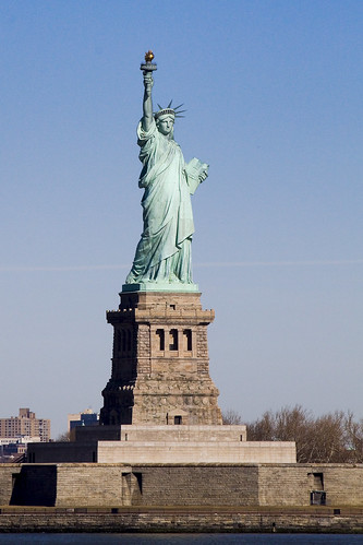
From the deck of the ferry you will have a perfect view of The Statue of Liberty and Ellis Island. You’ll see the skyscrapers and bridges of Lower Manhattan receding as you pull away and coming into focus again as you return.
A typical weekday schedule involves the use of five boats to transport approximately 60,000 passengers daily (109 daily trips). During the day, between rush hours, boats are regularly fueled and maintenance work is performed. Terminals are cleaned around the clock and routine terminal maintenance is performed on the day shift. On weekends, three boats are used (75 trips each Saturday and 68 trips each Sunday).
Over 35,000 trips are made annually.

– photo by Mitch Waxman
Mom is doing better, but still has a long way to go before she returns from disease to ease. Literal in my thinking, I often find myself lost in the technical aspect of words like “disease”- literally a lack of ease. I’m all ‘effed up.
It’s like the gulls say: ia, ia, ia
Kill Van Kull walk 2
for part one, click here

– photo by Mitch Waxman
The Kill Van Kull is an industrial waterway which provides a border between Staten Island and New Jersey, as well as serving the role of a maritime route between the Port of Newark and the greater body of water called New York Harbor or the New York Harbor Estuary- depending on your priorities. The New Jersey side of the Kill Van Kull is lined with modern docks and industrial facilities. The Staten Island side seems to have abandoned its industrial role, with storm shattered pilings and relict rail tracks found lining its banks.
from wikipedia
New York Harbor lies at the confluence of three major bodies of water. The harbor opens onto the New York Bight (Atlantic Ocean) to the southeast and the Long Island Sound to the northeast. Both of these are essentially marine bodies with both tides and saltwater, but the Sound compared to the Atlantic is about 20-30% less saline (as an estuary), and the tide is about 3 hours later with as much as 70% more variation. The Hudson River adds a fresher, non-tidal inflow from the north, although the tide and brackishness extend well up river.

– photo by Mitch Waxman
Critters abound along this cement clad shore, and large flocks of coastal and ocean fowl may be observed. My ignorance of the natural world is an ongoing handicap (why can’t I know everything about anything? … human… all too… human…) so I cannot describe the taxonomy of these birds. Perhaps a helpful Newtown Pentacle reader with ornithological knowledge can assist in identifying the specie observed above. I can tell you that they were apparent in great numbers, during the early days of March.
UPDATE: Sharp eyed reader Christina informs me that these are Brant Geese.
from army.mil
The U.S. Army Corps of Engineers New York District recently shared its plans to improve the New York – New Jersey Harbor Estuary with members of Congress and other key decision-makers. Representatives of more than 20 organizations joined the District commander aboard the USACE vessel Hayward tour of the estuary and the Hudson River.
“It’s the 400th anniversary of Henry Hudson’s historic exploration up this great river,” said Col. John R. Boulé II, New York District commander, addressing the group from the bow of the Hayward. “Our view must be very different from his. Years of industrialization have considerably degraded this part of the Hudson.”
The Corps plans to help turn back the hands of time on the estuary. The event to celebrated the unveiling of an innovative, comprehensive restoration plan created in collaboration with partners, and with a focus on restoring the estuary. This will create a healthier environment for fish and wildlife, and also provide the public cleaner waters, healthier fisheries, increased flood protection, recreational opportunities, and a boost to the region’s economy.
“The primary goal of the New York-New Jersey Harbor Estuary Comprehensive Restoration Plan is to develop a mosaic of habitats that provides maximum ecological and societal benefits to the region,” said Lisa Baron, project manager and marine biologist with the New York District.
A diverse group of USACE technical experts and consultants developed the plan as part of the Hudson Raritan Estuary Ecosystem Restoration Study sponsored by the Port Authority of New York and New Jersey. The plan was prepared in collaboration with the New York-New Jersey Harbor Estuary Program and more than 60 partnering organizations, including federal, state and local agencies, non-governmental organizations and regional stakeholders. The overall plan is unique in that these agencies are presently combining their funds and forces to reduce redundancy, become more efficient and save taxpayers a considerable amount of money. The plan will serve as a master guide and framework for restoration efforts throughout the estuary.
The plan involves many partners because the estuary spans 1,600 square miles across New York and New Jersey. An estuary is the area where the fresh waters of a river meet the salt water of the sea. The New York-New Jersey Harbor Estuary includes rivers, wetlands, coastline and open waters, and is located within a complex ecological system and a metropolitan region with a population of 20 million people. The plan’s boundary covers a large region of the estuary, which is a 25-mile radius around the Statue of Liberty National Monument.
“To perform restoration work in the estuary, the plan divides the estuary into eight regional areas associated with specific watersheds,” said Peter Weppler, chief of the New York District’s Coastal Ecosystem Section. He is a biologist with an extensive background in ecological investigations.
The plan includes 11 priority targets for restoration, recognized as Target Ecosystem Characteristics that include methods to restore and create habitats, ensure these habitats live in harmony and with the surrounding urban infrastructure, and to ensure the estuary is safe and accessible to the millions of estuary residents and visitors.

– photo by Mitch Waxman
The big show on the Kill Van Kull, of course, are the Tugboats transiting between the lower Harbor and the Port of Newark. Tugboats, for those of you unfamiliar with the role they are engineered to perform, act as precision guides that pilot and nudge ocean going vessels through the relatively shallow and tight quarters found in coastal waters. Powered by engines many times more powerful than required for vessels of their size and tonnage, Tugs are also designed with specially stiffened and overly robust frames which allow them to manipulate the elephantine ships that they shepherd to safe harbor. Pictured above is the Jill Reinauer. For an interesting window on the life of a tugboat crew and the hazards they face in New York Harbor, check out this post at piersystem.com.
from tuginformation.weebly.com
Built for Interstate Oil Transport by Main Iron Works of Houma, La in 1967 (hull #183) as the tug Ranger. She measures 91’(ft) long, with a 9’(ft) draft and 26’(ft) wide rating at 2,000 horsepower.
At the time Interstate Oil Transport had two fleets. Their Northeast Fleet “Green Fleet” that operated in Philadelphia, Pennsylvania. And a Southern Fleet “White fleet” which operated out of Tampa, Florida. The Ranger was assigned to the “Green Fleet.” However, many changes came to Interstate Oil, a company called Southern National Resources (also known for a time as SONAT Marine) purchased Interstate Oil Transport. SONAT eventually sold out to Maritrans Operating Partners LLP.
In 1998, Maritrans’s northeast fleet was thinned. Many of the vessels where acquired by K-Sea Transportation Partners. Reinauer Transportation acquired three vessels, the Ranger was one of the three vessels. She was renamed the Jill Reinauer the others vessels Reinauer acquired where the Interstate Transporter (Kristy-Ann Reinauer), and the Delaware (Curtis Reinauer). In 2005, the Jill Reinauer was re-powered with MTU engines and fitted with canted windows in her main wheelhouse to reduce glare in the wheelhouse, and was fitted with an upper wheelhouse as well, this work was done at Reinauer’s yard in Staten Island, New York.

– photo by Mitch Waxman
A sudden flurry of activity on the Kill Van Kull began when the Charles D. McAllister sped by, after having passed beneath the elegant Bayonne Bridge (designed by Omar Othman under the guidance of Gustav Lindenthal, who designed the Hells Gate Bridge spanning the East River nearby storied Astoria). For a different perspective on the Kill Van Kull and lots of information on the Chemical Coast of New Jersey, Bayonne Bridge, and Port of Newark- check out the Newtown Pentacle postings from June of 2009 here, and here.
also from tuginformation.weebly.com
Built in 1967 as the Esso Bayou State by Jacksonville Shipyard of Jacksonville, FLA. Rated at 1,800 horsepower she is driven by two Caterpillar 12-D398 Turbo main engines, with Lufkin reduction gears with a ratio of 7.14:1 She is a twin screw tug, fitted kort nozzles and flanking rudders. She is outfitted with two fire monitors that produce 1,500 Gallons Per Minute. She has a fuel capacity of 26,670 gallons, 628 gallons of Lube Oil and 3,480 gallons of potable water.
She was later renamed the Exxon Bayou State, and when Exxon became Sea River Maritime, her name was altered to S/R Bayou State. When Sea River sold off their assets she was acquired by McAllister Towing and Transportation she was renamed the Charles D. McAllister and is currently assigned to McAllister’s New York, New York fleet.

– photo by Mitch Waxman
Moran towing’s Cape Cod shot past at what seemed to be it full 4,200 HP throttle, undoubtedly in an urgent rush. Note the lesson in physics illustrated by the waveforms around the speeding tug. The warping of the water’s surface illustrate the principles of displacement, surface tension, and offer visible waveforms for study.
from tugboatenthusiastsociety.org
Tugs are “displacement” hull vessels, the hull is designed so water flows around it, there is no consideration for having the vessel “plane”. Because of this the hull form is limited to a maximum speed when running “free” that is about 1.5 times the square root of the waterline length. As the tug approaches this speed when running “free” it is perched between the bow wave and the stern wave. Since the hull cannot plane, application of additional power when approaching maximum hull speed only results in a larger bow wave, with the tug “squatting” further into the trough.

– photo by Mitch Waxman
The Amy C McAllister was next on the parade, and it seemed to also be in quite a hurry. Something was approaching, something big.
also from tuginformation.weebly.com
Built in 1975, she was formerly named the Jane A. Bouchard. She is fitted with two EMD 16-645-E2 main engines for a rating of 4,000 horsepower turning two Falk reduction gears at a ratio of 4.708:1. She is also fitted kort nozzles, and flanking rudders with a Smatco single drum towing winch outfitted with 2,200′ (ft) of 2 ¼” (in) towing wire. When she was acquired by McAllister Towing and Transportation she was renamed the Amy C. McAllister.
She is currently assigned to McAllister’s New York, New York Fleet.

– photo by Mitch Waxman
Turns out that “something big” was the Eagle Beaumont, a gargantuan fuel ship which was flagged in far off Singapore. Sources reveal that the Eagle Beaumont is an “aframax tanker“, was built at the Korean Samsung Heavy Industries Yard in 1996, has a maximum DWT of 99,448, and is a double hulled vessel classified as “1A1 Tanker for Oil ESP E0 LCS-SI” with a worth of some $52 million.
from aet-tankers.com
AET’s double-hulled VLCC fleet is managed from London and is mostly engaged in the Atlantic trades, as well as longer haul trips to the US West Coast. There are currently 11 vessels in this fleet with an average age of less than five years. Growing VLCC capability is a priority and we are on target to achieve a 25-strong fleet within the next five years.
The fleet of aframax vessels forms the core of AET’s crude oil activities. All double-hulled and with an average age of around 9 years, these workhorses of the tanker industry transport crude oil in Europe, Asia and the Americas. This fleet and its global footprint will continue to grow, to provide increased connectivity between geographic regions and between our VLCC operations and our lightering activities.
AET vessels are employed for customers on long-term period charters, shorter voyage charters or on extended contracts of affreightment (COAs). The dedicated chartering teams in London, Singapore, Gurgaon and Houston work alongside our customers to ensure we deliver the best possible solutions.

– photo by Mitch Waxman
The two tugs maneuvering the Eagle Beaumont in the narrow space of the Kill Van Kull are the aforementioned Amy C. McAllister and a second McAllister tug which escapes my identification due to the shadows cast by the titanic fuel tanker. My suspicions point to the Charles B. McAllister, but the wheel house exhibits minor differences from the shot above, so I’m probably wrong. At any rate, they performed a rotation of the tanker using sturdy cables and precision coordination of effort.
from wikipedia
Tankers used for liquid fuels are classified according to their capacity.
In 1954 Shell Oil developed the average freight rate assessment (AFRA) system which classifies tankers of different sizes. To make it an independent instrument, Shell consulted the London Tanker Brokers’ Panel (LTBP). At first, they divided the groups as General Purpose for tankers under 25,000 tons deadweight (DWT); Medium Range for ships between 25,000 and 45,000 DWT and Large Range for the then-enormous ships that were larger than 45,000 DWT. The ships became larger during the 1970s, and the list was extended, where the tons are long tons:
- 10,000–24,999 DWT: General Purpose tanker
- 25,000–44,999 DWT: Medium Range tanker
- 45,000–79,999 DWT: Large Range 1 (LR1)
- 80,000–159,999 DWT: Large Range 2 (LR2)
- 160,000–319,999 DWT: Very Large Crude Carrier (VLCC)
- 320,000–549,999 DWT: Ultra Large Crude Carrier (ULCC)

– photo by Mitch Waxman
From the direction of the Port of Newark, a behemoth container ship suddenly appeared. Notice how high it’s riding in the water, signifying that its pessimistically half empty. A Liberian flagged 231 meter long by 32 meter wide ocean going vessel, it was built in the year 2000, and is capable of moving at 21.1 knots. Another product of the Samsung Heavy Industries yard in Korea, it’s the Santa Carolina.
from wikipedia
Samsung Heavy Industries or SHI (Korean: 삼성중공업, Hanja: 三星重工業) is the second-largest shipbuilder in the world and one of the “Big Three” shipbuilders of South Korea. A core subsidiary of the Samsung Group, South Korea’s and the world’s largest conglomerate, SHI’s main focus is on shipbuilding, offshore floaters, digital devices for ships, and construction and engineering concerns.
SHI operates manufacturing facilities at home and abroad, including ship block fabrication factories in Ningbo and Rongcheng, China. The Geoje Shipyard in particular, SHI’s largest shipyard in South Korea, boasts the highest dock turnover rate in the world. The largest of the three docks, Dock No. 3, is 640 meters long, 97.5 meters wide, and 13 meters deep. Mostly ultra-large ships are built at this dock, having the world’s highest production efficiency with yearly dock turnover rate of 10 and the launch of 30 ships per year.[2]
SHI specializes in the building of high added-value and special purpose vessels, including LNG carriers, off-shore related vessels, oil drilling ships, FPSO/FSO’s, ultra Large container ships and Arctic shuttle tankers. In recent times SHI has concentrated on LNG tankers and drillships, for which it is the market leader.

– photo by Mitch Waxman
The Laura K. Moran tug appeared, and took up its position to guide the Santa Carolina through the narrow hazards faced by the Santa Carolina passing by the Eagle Beaumont. Realize that a ship of this size is incapable of stopping on a dime, and the dynamics of such massive objects suggest vast kinetic energy transfers should they accidentally come in contact with other objects. An interesting point of language, interesting to your humble narrator at least, in the correct usage of the words allision and collision. An Allision is used when a moving object strikes a fixed object- i.e. when a ship strikes a pier or shoreline feature. A Collision is when two moving objects meet. The job of the Tugboat Captain is to avoid either.
from boatinglaw.com
When one thinks of admiralty law the archetypical fact pattern that comes to many people’s minds is a collision or allision (vessel contact with a fixed object). There are many well ingrained legal concepts and rules, some of which are unlike anything found in land based law.
First, when there has been a collision or allision the vessel herself may be sued as if she were a person. This is an “in rem” action and the complaint is against the vessel her tackle her engines and appurtenances.
Second, under general maritime law, each vessel must pay in proportion to the amount that it was at fault. This rule stands in stark contrast to state law in a those states, including Maryland, where plaintiffs who bear any fault can be barred from all recovery.
Third, there are several judicial presumptions of fault that all vessel operators should bear in mind. A vessel creating wake is presumed at fault for damage caused by wave wash. A vessel in violation of any safety statute which could have prevented the casualty is presumed at fault. A vessel that is drifting or dragging anchor is presumed at fault. A vessel that allides with a fixed object (unless it is submerged) is presumed at fault.
Fourth, there are several sources of fault in addition to the judicial presumptions including, statutory violations, local rules, unseaworthiness of your vessel and custom. If you violate a custom you may well find yourself liable for the casualty. A prime example of a custom is the Point Bend Custom on the Mississippi River. Since the current flows fastest on the outside of a bend and slower under a point of land, all downbound traffic travels around the outside of a bend while upriver traffic takes advantage of reduced current by traveling from point of land to point of land. This creates a situation in which large vessels must weave through each other’s paths.

– photo by Mitch Waxman
In fact, the two ships were quite a distance from each other, but in nautical terms, this is a tight squeeze for the vagaries of displacement and current are somewhat unpredictable. The Tug crews that inhabit New York Harbor carry a knowledge passed from father to son and captain to deckmate, and represent millions of hours of applied labor and hard won familiarity with the liquid thoroughfare of the Kill Van Kull. No room for error is to be found as they nudge and pull, and mistakes can be deadly to crew and environment alike. The Kill Van Kull is only a thousand feet wide, after all.
from shipsnostalgia.com
Errors in judgment by the navigators aboard two tanker ships carrying volatile cargos resulted in a collision, explosion and fire that consumed both tankers, two attending tugs and left 37 sailors dead and more than 20 injured in New York harbor on June 16, 1966.
The fiery accident remains counted even today as among the deadliest shipwrecks in the history of New York Harbor.
The tankers, the British MV Alva Cape was entering the harbor with a cargo of naphtha and was struck amidships on the starboard side by the outgoing American tanker Texaco Massachusetts. The raging explosion and fire that resulted from the crash destroyed not only the tankers but the tugs Latin America and Esso Vermont.
Thirty-four sailors perished during this first explosive event on July 3. Nineteen of them perished on the Alva Cape, eight on the Esso Vermont, three on the Texaco Massachusetts and three on the tug Latin America. The U.S. Navy, Coast Guard and New York City fire boats worked together to battle the flames and rescue as many sailors as possible from the burning vessels in a place with the ominous name of Kill Van Kull Channel.
The blaze was finally extinguished, but the Alva Cape was not finished as a human death trap. Three more men were killed in yet another explosion while they were aboard the burned out wreck, attempting to unload what remained of its deadly cargo. This happened just 12 days later, bringing the death toll from the accident to 37.

– photo by Mitch Waxman
Along the Staten Island coastline, an abandoned rail line is observed. Forgotten-NY has rolled through here, and as always, wrote the book on Cornelius Vanderbilt’s SIRT.
check out the words of the Master- click here

– photo by Mitch Waxman
Inheritances of the industrial revolution such as these rusted tracks litter the North Shore of Staten Island. The lovely homes and tree lined streets nearby are sited, unfortunately, amongst the toxic inheritances of the heroic age of the mills and factories which defined the area- which cause your humble narrator to muse on analogies to Maspeth and Greenpoint, found along the route of the malefic Newtown Creek as it gurgles along the currently undefended border of Brooklyn and Queens.
from wikipedia
Much of the North Shore is industrialized, which when paired with the fumes being exuded from New Jersey factories, helps to give Staten Island the worst smog in New York City. According to the New York State Department of Health, deaths from lung cancer are 48% higher on Staten Island than in the city as a whole. The poorest air quality being on the North Shore of the island. Within the North Shore’s approximately 5.2 square mile area, there has been around 21 different sites that the Environmental Protection Agency or residents have identified as contaminated. All of them sit within 70 feet of homes and apartment buildings, and residents believe that many violate state environmental regulations.
While the famed Fresh Kills Landfill much further South on the island has received large media coverage for its harmful effects, eventually leading to its closing in 2001, the numerous problems on the North Shore have gone ignored. The demographics of those who live around the former landfill differ quite drastically from those who live on the island’s North Shore, leading some to point the finger at racism and classism as answers to why so many North Shore sites remain contaminated.

– photo by Mitch Waxman
The Santa Carolina threaded through the Kill Van Kull without incident, as do most of the hundreds of large ships that pass through it daily. The redoubtable Army Corps of Engineers is involved in a multi year project to deepen the Kill so as to accommodate even larger trans oceanic shipping and ensure that the Port of Newark remains a primary destination for all the world’s traders and merchants.
from wikipedia
Planned and built during the 1950s by the Port Authority, it is the largest container port in the eastern United States and the third largest in the country. Container goods typically arrive on container ships through the Narrows and the Kill Van Kull before entering Newark Bay, a shallow body of water which is dredged to accommodate the larger ships (some ships enter Newark Bay via the Arthur Kill). The port facility consists of two main dredged slips and multiple loading cranes. Metal containers are stacked in large arrays visible from the New Jersey Turnpike before being loaded onto rail cars and trucks. The building of the port facility antiquated most of the waterfront port facilities in New York Harbor, leading to a steep decline in such areas as Manhattan, Hoboken, and Brooklyn. The automated nature of the facility requires far fewer workers and does not require the opening of containers before onward shipping.
Today, the major Port operators at Port Newark-Elizabeth include Maher terminals, APM terminal (A. P. Moller-Maersk), and PNCT (Port Newark Container terminal).
Other significant seaport terminals under the auspices of the Port Authority of New York and New Jersey include: Global Marine Terminal in Jersey City, NJ; NYCT (New York Container Terminal) in Staten Island, NY; and Red Hook Container Terminal at the Brooklyn Marine Terminal in Brooklyn, NY.

– photo by Mitch Waxman
I wonder if this duck knows that menacing “menage a mallard” that I saw at Dutch Kills a few weeks ago? Couldn’t be the same suspicious quacker, could it?
from wikipedia
The Kill Van Kull is a tidal strait approximately 3 miles (4.8 km) long and 1,000 feet (305 m) wide separating Staten Island and Bayonne, New Jersey, USA. The name kill comes from the Middle Dutch word kille, meaning “riverbed” or “water channel.”
Kill Van Kull connects Newark Bay with Upper New York Bay. The Robbins Reef Light marks the eastern end. Historically it has been one of the most important channels for the commerce of the region, providing a passage for marine traffic between Manhattan and the industrial towns of New Jersey. Since the final third of the 20th century, it has provided the principal access for ocean-going container ships to Port Newark-Elizabeth Marine Terminal, the busiest port facility in the eastern United States and the principal marine terminal for New York Harbor.
Kill Van Kull walk 1

– photo by Mitch Waxman
A legendarily squalid and desolate abode of pirates, gangsters, and irresolute opportunists- the docks of Manhattan- have been recast by modernity as “the financial district”- and simply referred to as “wall street”. The end of the line, the Staten Island Ferry docks at South Ferry and offers a free maritime connection between the far flung Staten Island and Manhattan across New York Harbor. The boat leaves every half hour, like clockwork (and the fleet is orange).
from wikipedia
The origin of the name South Ferry is probably one of the more misunderstood trivia, even to New Yorkers accustomed to using it in a geographical sense. One would suppose that it is so called because it is at the southern tip of Manhattan, and it hosts ferries. In actuality, it was the name of the South Ferry, one of several ferries between what were then the separate cities of New York and Brooklyn. The “Old Ferry”, which later was renamed the “Fulton Ferry”, crossed between Manhattan and Brooklyn from streets that in each city would eventually be renamed “Fulton Street” after the ferry company. The “New Ferry” crossed further east, between Catherine Street in Manhattan, and Main Street in Brooklyn.
As the City of Brooklyn grew, the area south of Atlantic Avenue (known as “South Brooklyn”) began to become built-up, but lacked easy access to the ferry terminals in the northern parts of the city of Brooklyn. Thus, a new ferry was established in 1836 to take passengers directly to Atlantic Avenue and the southern parts of the City of Brooklyn, and so was called the “South Ferry”. The ferry connected to the foot of Atlantic Avenue in Brooklyn and the Brooklyn and Jamaica Railroad (later part of the Long Island Rail Road) through the Cobble Hill Tunnel. In addition, South Ferry was the name of the Brooklyn landing and ferry house of the aforementioned ferry.

– photo by Mitch Waxman
Another great opportunity to take photos of the shining city is offered by this short trip, and one must pick a spot soon after boarding or the masses of camera wielding citizenry will cheat you out from an unoccluded vantage point. Staten Island is a rapidly growing part of New York City, a hilly district of quiet and well planted streets that frame envious homes on one shore, and highways lined with medium density apartment houses and condominiums on the other which are served by a never ending series of strip malls and the occasional “big box” store. The older sections of the community are of maritime heritage, largely, and clustered around the Kill Van Kull.
from wikipedia
In the 1700s ferry service between Staten Island and the city of New York (then occupying only the southern tip of Manhattan) was conducted by private individuals with “periaugers”, shallow-draft, two-masted sailboats used for local traffic in New York harbor. In the early 1800s, Vice President (and former New York governor) Daniel D. Tompkins secured a charter for the Richmond Turnpike Company, as part of his efforts to develop the village of Tompkinsville; though intended to build a highway across Staten Island, the company also received the right to run a ferry to New York. The Richmond Turnpike Company is the direct ancestor of the current municipal ferry.
In 1817 the Richmond Turnpike Company began to run the first motorized ferry between New York and Staten Island, the steam-powered Nautilus. It was commanded by Captain John De Forest, the brother-in-law of a young man named Cornelius Vanderbilt. In 1838 Vanderbilt, who had grown wealthy in the steamboat business in New York waters, bought control of the company. Except for a brief period in the 1850s, he would remain the dominant figure in the ferry until the Civil War, when he sold it to the Staten Island Railway, led by his brother Jacob Vanderbilt. (Three of the Staten Island ferries were requisitioned by the United States Army for service in the war, but none ever returned to New York harbor.)
– photo by Mitch Waxman
Just after passing Liberty Island, an abundance of industrial terminals and petroleum mills are apparent. A dizzying display of technology may be observed as the Ferry makes its way from Manhattan to Staten Island, and the lighting conditions demand a morning trip for photographic opportunities to be realized. You don’t have to be up fiendishly early, these shots for instance, were from a ferry ride that left Manhattan at 9:30 AM.
from nyc.gov
The Staten Island Ferry has been a municipal service since 1905, and currently carries over 21 million passengers annually on a 5.2-mile run between the St. George Terminal in Staten Island and the Whitehall Terminal in lower Manhattan. Service is provided 24 hours a day, 365 days a year. The Staten Island Ferry is the most reliable form of mass transit, with an on-time performance of over 96 percent.
A typical weekday schedule involves the use of five boats to transport approximately 65,000 passengers daily (110 daily trips). A four-boat (15 minute headway) rush hour schedule is maintained. During the day, between rush hours, boats are regularly fueled and maintenance work is performed. Terminals are cleaned around the clock and routine terminal maintenance is performed on the day shift. On weekends, three boats are used (64 trips each weekend day). Over 33,000 trips are made annually. Ferry terminal supervisors, assigned around the clock at both Whitehall and St. George, are responsible for ensuring that the ferry operates according to its published schedule (pdf) or (html).

– photo by Mitch Waxman
That’s the Vane Bros. Choptank, a very modern tug built by Thoma-Sea, a shipbuilder which operates out of the Lockport shipyard in Houma, LA. Vane Bros. and its plans for an ultra modern fleet was featured in a 2007 feature at professionalmariner.com.
from vanebrothers.com
The tug Choptank is the fifth in a line of Patapsco-class tugs. Like her sister tugs, she was designed by Frank Basile of Entech & Associates, and built by the Thoma-Sea Boat Builders in Houma, Louisiana. She joined the fleet in January 2007, and was subsequently named one of the “17 top new tugs of 2007” by American Tugboat Review, an annual publication of Professional Mariner.
The Choptank is 95’ long, 34’ abeam, and 15’ deep. Her gross tonnage is 99 tons. She is powered by two CAT 3516, 2100 horsepower engines with Kort nozzles, and maintains running speeds of better than 12 knots. Featuring a model bow and square stern, her fuel capacity is approximately 90,000 gallons. Potable water capacity is approximately 9,000 gallons. With accommodations for seven crew members, the Choptank is dedicated to 50-class tank barges on the coastwide trade.

– photo by Mitch Waxman
I love this boat, the Tug Ellen McAllister. A familiar sight in New York Harbor, it’s actually the same age as I am. I mentioned this ship in a posting about last June’s Working Harbor Committee “Sunset Cruise”.
The tug Ellen McAllister was originally built for the U.S. Navy, as the Piqua, at the Marinette Marine Shipyards in Wisconsin in July of 1967. The Piqua’s anchorage for many years was at Holy Loch, Scotland. It spent most of its naval career providing tug services for the 1st naval district and the Atlantic Fleet. It was sold under its current name in 2001 to McAllister Towing.
– photo by Mitch Waxman
Over there, that’s the Peter F. Gallatly, another Thoma-Sea built ship. A 1,200 HP, 327 GT tugboat, it went into service in December of 2008.
PETER F. GELLATLY
Official #: 1212432
- Year Built: December, 2008
- Dimensions: 100’L x 34’B x 15’D (Molded)
- Gross Tons: 327 tons
- Net Tons: 98 tons
- Draft Loaded: 13.6 Feet
- Speed Light: 11 Knots
- Classifications: Endorsement for Oceans, Coastwise Trade, ABS Load Line
- Eye Level: Lower Pilot House (23 Feet)
- Upper Pilot House (40 Feet)
- Capacities:
- Fuel Oil 85,900 Gallons
- Lube Oil 662 Gallons
- Hydraulic Oil 496 Gallons
- Gear Oil 662 Gallons
- Potable Water 8,816 Gallons
- Ballast Water 10,621 Gallons
- Dirty Bilge 1,263 Gallons
- Dirty Lube Oil 1,306 Gallons
- Grey/Brown Water 3,898 Gallons (ZERO (0) Discharge Compliant)
- Horse Power: 4,200 Continuous
- Main Engines: (2) 3516 CAT @ 1600 RPM Tier 2 Compliant
- Reduction Gears: (2) Reintjes WAF 11 37 7.087:1 Reduction with Shaft Brakes
- Propellers: (2) Rolls-Royce Stainless Steel (4) Blades GWAN 104″ x 77″
- Pitch ABS Open Wheel
- Shafts: 9 1/2″ Diameter
- Generators: (2) John Deere 6068T 99KW 120/208V Tier 2 Complaint
- Towing Winch: (1) Intercon DD200 Double Drum with Level Winder and Capsan
- 2,200′ x 2 ¼” Galv. Cable
- 1,000′ x 1 3/4″ Galv. Cable
- John Deere Engine, Torque Converter Tier 2 Complaint
- Towing Arch: 8″ x Sch. 120 with (2) Bronze Bushed Sheaves
- Air Compressors: (2) Quincy 325 Operating @ 150 PSI with 160 Gallon Receiver
- C02 System: Herbert Hiller

– photo by Mitch Waxman
Just as the Ferry was maneuvering into its dock at St. George Terminal on Staten Island, Ellen McAllister was good enough to move into an egregious spot. This tugboat, of course, was the Division A winner of the 17th Annual Running of the Great North River Tugboat Race & Competition in 2009 and its Captain, Kirk Watts, won the contest for “Best Tattoo”. I was on a circleline observer boat at the event, and photos from the race can be found in this set at flickr.
from tuginformation.weebly.com
McAllister Towing is one of the oldest and largest marine towing and transportation companies in the United States. They operate a fleet of more than seventy tugboats and twelve barges along the East Coast from Portland, Maine to San Juan, Puerto Rico.
Although their corporate headquarters are located in New York City they operates in the ports of: Portland Maine, Staten Island New York, Philadelphia, Pennsylvania; Baltimore, Maryland; Hampton Roads, Virginia; Wilmington North Carolina, Georgetown, and Charleston, South Carolina as well as Jacksonville, and Port Everglades, Florida; including San Juan Puerto Rico. McAllister engages in ship docking, general harbor towing, coastal towing and bulk transportation.
Captain James McAllister started the first McAllister enterprise shortly after he arrived from Cushendall, County Antrim, Ireland . Together with his brothers and in-laws, McAllister formed the Greenpoint Lighterage Company. They augmented the lighterage business with towing, with the acquisition of their first steam tug, the R.W. Burke, in the 1880’s, while the Brooklyn Bridge was still being built. In the early twentieth century there was a period of innovation and expansion. Captain James was one of the first to convert a sail lighter into a bulk oil carrier, for the transport of oil around New York Harbor. The company also became known nationally for its salvage work, which extended from the West Indies, along the Atlantic Coast as far north as Maine.
In 1909, the company acquired the Starin Fleet of steamboat excursion vessels, forming the McAllister Steamboat Company, which was then among the largest excursion boat operators in New York, with regular runs to the Statue of Liberty, Bear Mountain, Coney Island, and Long Island. After the death of Captain James in 1916, his four sons assumed control of the company. The new partnership consisted of James, John E., Charles D. and William H., the second generation of McAllisters.
chugging along…

– photo by Mitch Waxman
An unholy and untrammeled period of exertions, which have left your humble narrator a hollow eyed wreck in the last few days, are nearly complete. A short missive this morning, as I am off to the shores of “sub jersey”, or Staten Island as the rest of you might describe it, to meet with my aged mother’s physicians. The poor woman’s health collapsed several years ago, and on doctor’s orders, we moved her into a nursing home. Luckily, dementia has shielded her from the depersonalization and horror of institutionalization- her constructed reality is filled with deceased loved ones and the belief that she is going home “tomorrow”.

– photo by Mitch Waxman
Unfortunately for my Mom, and even worse for the facility she resides in, she has developed a bed sore of some severity which has forced me to turn my attentions to Staten Island. A pressure ulcer, which is to be expected in patients suffering from her portfolio of illness but is nevertheless representative of neglectful failure for her caregivers, developed to Stage 4 (which I won’t even link to wikipedia to explain, as it’s that hideous). An open wound the size of softball, it is on her back and advanced enough to have required surgical debridement last week. An investigation into “how this advanced so quickly”, and “when, who, what, and how often” was initiated at my insistence by the administration of the Nursing Home, the findings of which are the point of my trip to… “sub jersey” today.
Something wicked this way comes… if you see a filthy black raincoat tattering down Victory Blvd. today… beware the coming of the Ides. Know that a storm is arrived, venom will be spat, and the dragon loosed.
Delayed by obligation, the next installment of “Creek Week” is on the stove and simmering, expect it tomorrow…
Gloomy Mansions

NY Harbor – photo by Mitch Waxman
A recent trip to the cyclopean waterfront of the Port of Newark was marred and occluded by a pervasive blanket of precipitant fog. Suffering from the cold wind and occasional bursts of rain, all around me a ghost city dithered into atmospheric perspectives. Ghosts have been everywhere, during our metropolitan hour of the wolf, in the first decade of the 21st century- here in New York City- where the Terror Wars started.
As the ship carrying the Working Harbor Committee party to its destination left the East River and entered the Upper Harbor approaching Staten Island, one ghost in particular came to mind. A spirit of spectral power is invoked and controlled by knowledge of its true name, according to the hermetic traditions, and the true name of god itself offers the key to mastery of the universe.
Names have power, and in the case of this ghost, the name is Willowbrook.
from wikipedia
The Harbor reached its peak activity in March 1943, during World War II, with 543 ships at anchor, awaiting assignment to convoy or berthing (with as many as 425 seagoing vessel already at one of the 750 piers or docks). 1100 warehouses with nearly 1.5 square miles (3.9 km2) of enclosed space served freight along with 575 tugboats and 39 active shipyards (perhaps most importantly New York Naval Shipyard founded 1801). With a staggering inventory of heavy equipment, this made New York Harbor the busiest in the world.
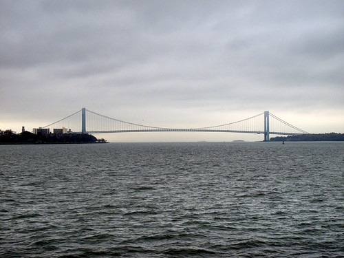
Verrazano Narrows Bridge – photo by Mitch Waxman
A well known film director, whose cinematic subject matter suggests familiarity with Theosophy and other bizarre occult concepts, once opined “that haunted houses are like stone tape decks playing back an endless loop of the suffering and negativity recorded within them”. If one considers such fancies as true, Willowbrook might be considered as a recording studio.
In 1942, a residential hospital facility’s construction was completed on Staten Island. It was commandeered by the Army to act as a hospital for wounded combatants from WW2. In 1947, New York State’s Dept. of Mental Hygiene took over the complex and renamed it the Willowbrook State School. The intended population of the facility was to be the “mentally retarded” (an archaic term from before the advent of modern NewSpeak which describes this group as “Developmentally Disabled“).
from wikipedia
The natural depth of New York Harbor is about 17 feet (5 m), but it has been deepened over the years, to about 24 feet (7 m) controlling depth in 1880. By 1891 the Main Ship Channel was minimally 30 feet (9 m). In 1914 Ambrose Channel became the main entrance to the Harbor, at 40 feet (12 m) deep and 2,000 feet (600 m) wide. During World War II the main channel was dredged to 45 feet (14 m) depth to accommodate larger ships up to Panamax size. Currently the Corps of Engineers is contracting out deepening to 50 feet (15 m), to accommodate Post-Panamax container vessels, which can pass through the Suez Canal. This has been a source of environmental concern along channels connecting the container facilities in Port Newark to the Atlantic. PCBs and other pollutants lay in a blanket just underneath the soil.
In June 2009, the Bloomberg administration announced plans for 200,000 cubic yards of dredged PCBs to be “cleaned” and stored en masse at the site of the former Yankee Stadium, as well as at the Brooklyn Bridge Park. In many areas the sandy bottom has been excavated down to rock and now requires blasting. Dredging equipment then picks up the rock and disposes of it. At one point in 2005 there were 70 pieces of dredging equipment in the harbor working to deepen the harbor, the largest fleet of dredging equipment anywhere in the world. The work occasionally causes noise and vibration that can be felt by residents on Staten Island. Excavators alert residents when blasting is underway.

Drydocks, Kill Van Kull – photo by Mitch Waxman
Willowbrook was notoriously overcrowded, performed experimental and grossly unethical scientific explorations, and because of it- the Federal “Civil Rights of Institutionalized Persons Act of 1980” was instituted to guarantee the civil rights of the vulnerable souls housed in these “snakepits”. Geraldo Rivera, when he used to be a reporter, brought the case to national prominence. Long time New Yorkers still shudder at just the mention of the word.
But, there’s another Willowbrook story- another ghost.
from wikipedia
Geologically, Staten Island was formed in the wake of the last ice age. In the late Pleistocene between 20,000 and 14,000 years ago, the ice sheet that covered northeastern North America reached as far south as present day New York City, to a depth of approximately the same height as the Empire State Building. At one point, during its maximum reach, the ice sheet precisely ended at the center of present day Staten Island, forming a terminal moraine on the existing diabase sill. The central moraine of the island is sometimes called the Serpentine ridge because it contains large amounts of serpentine group minerals.
At the retreat of the ice sheet, Staten Island was connected by land to Long Island because The Narrows had not yet formed. Geologists’ reckonings of the course of the Hudson River have placed it alternatively through the present course of the Raritan River, south of the island, or through present-day Flushing Bay and Jamaica Bay.
As in much of North America, human habitation appeared in the island fairly rapidly after the retreat of the ice sheet. Archaeologists have recovered tool evidence of Clovis culture activity dating from approximately 14,000 years ago. The island was probably abandoned later, possibly because of the extinction of large mammals on the island. Evidence of the first permanent American Indian settlements and agriculture are thought to date from about 5,000 years ago (Jackson, 1995), although early archaic habitation evidence has been found in multiple locations on the island (Ritchie 1963).

Salt Barge, Kill Van Kull – photo by Mitch Waxman
A homeless man who called himself Andre Rand, a one time employee of Willowbrook, set up a squatters residence for himself in the tunnels below and on the grounds of the abandoned hospital (which was finally closed in 1987, although parts of its grounds are used by CUNY in modernity).

Andre Rand at his arrest, from slantmagazine.com
Mr. Rand was convicted for the death of a 12 year old girl who was went missing on Staten Island in 1987. He has since become implicated in a string of area child disappearances stretching back to the 1960’s and refers to himself as “the Ted Bundy of child killers”. Rand is profiled in a recent film I’m anxious to watch, called “Cropsey“.
from wikipedia
The boroughs of New York City straddle the border between two geologic provinces of eastern North America. Brooklyn and Queens, located on Long Island, are part of the eastern coastal plain. Long Island is a massive moraine which formed at the southern fringe of the Laurentide Ice Sheet during the last Ice Age. The Bronx and Manhattan lie on the eastern edge of the Newark Basin, a block of the Earth’s crust which sank downward during the disintegration of the supercontinent Pangaea during the Triassic period. The Palisades Sill on the New Jersey shore of the Hudson River exposes ancient, once-molten rock that filled the basin. Tough metamorphic rocks underlie much of Manhattan, providing solid support for its many skyscrapers.

Salt Barge, Kill Van Kull – photo by Mitch Waxman
I find it disturbing, that a serial killer was loose on Staten Island and I had no idea about it. Even more unsettling, from the “urban explorer point” of view, is that Rand had set up camp in exactly the sort of place that the intrepid photographer is looking for when searching for “locations”. I’ve often mentioned that I don’t cross fences, admonished those who do trespass (while admiring their work), and offered advice on the cultural temperatures and urban hazards encountered when entering certain extant locales. Part of the reason for doing this is that you never know who you’re going to meet back there, alone and cut off from help.
There are weird things that happen, in the City of Greater New York.
a recent clipping from a wire service, for instance, makes me wonder- and more than wonder…
3 Bags Containing Body Parts Are Found in Brooklyn. THE ASSOCIATED PRESS- Published: August 30, 2009- The police said three plastic bags containing the skeletal remains of various body parts were found in Brooklyn. The bags, two of which enclosed suitcases containing the remains, were found Sunday on a street in Bedford-Stuyvesant. The medical examiner was working to identify the parts, as well as the sex, race and cause of death. There have been no arrests.
from sedona.biz
According to the National Research Council, we Americans dump between 8 million to 12 million tons of salt on our roads per year. Massachusetts, New Hampshire and New York report the highest level of salt use, with New York weighing in at 500,000 tons per year. The New York State Department of Transportation requires a road-salt application rate of 225 pounds per lane-mile for light snow and 270 pounds per lane-mile for each application during a heavy snow storm.
When you consider that there are approximately 6,000 miles of paved roadways near New York watersheds, you begin to see how all that road salt adds up. Some roads may get up to 300 tons of road salt per lane-mile each year. Recently, many scientists have begun to study the effects of so much road salt on ecosystems, water quality, public health and road quality. Here are a few things you should know before your break out that sodium chloride, the most commonly used de-icer.


