Posts Tagged ‘United States Army Corps of Engineers’
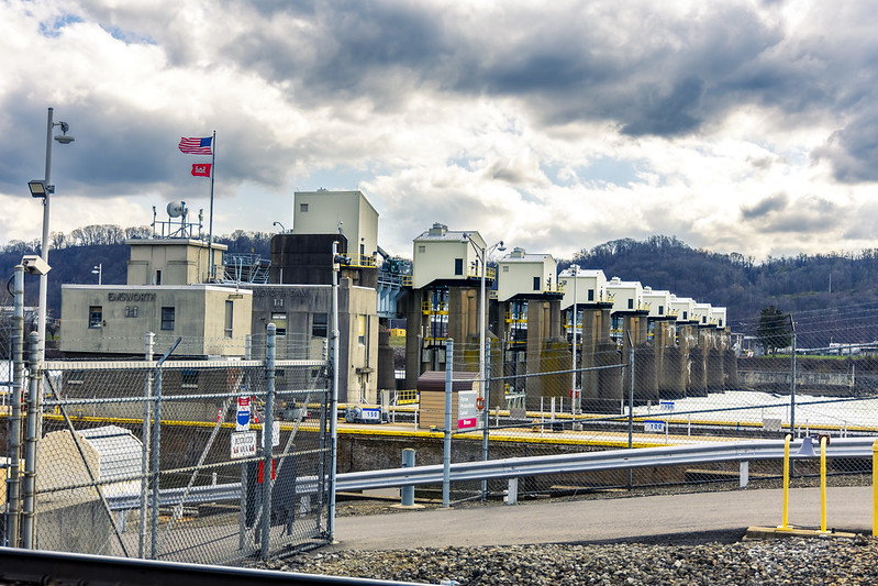
Emsworth Lock and Dam
Wednesday
– photo by Mitch Waxman
As part of a humble narrator’s continuing exploration of the Pittsburgh metro area, an afternoon in late March found me standing at the fence lines of an United States Army Corps of Engineers installation called the Emsworth Locks and Dam, on the Ohio River. As it turned out, I missed a dramatic set of events here which would occur in early April when an unusually high volume of rainfall caused all sorts of chaos here in the local vicinity.
Hullabaloo, I tell’s ya, hullabaloo.
The Three Rivers overflowed their banks which flooded several waterfront parcels, and here at Emsworth – 26 maritime barges which were tied up upriver that were full of minerals got loose from their moorings, and ended up wedged up against the dam.
Before you ask, I followed my usual policy of staying the hell away from such horrors unless someone was specifically going to be paying me to take the risk, in order to get a photo or deliver a video.
– photo by Mitch Waxman
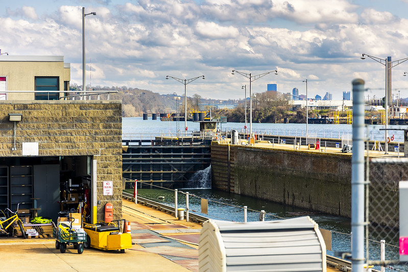
As mentioned above, this particular afternoon was one of my ‘exploratory trips’ wherein a series of waypoints were encoded into a Google map, which I then followed while driving the Mobile Oppression Platform from place to place. This one wasn’t a walk, it was a drive.
So far, my ‘get out there and see something’ instincts have been drawing me up the Monongahela and Allegheny rivers away from the center of Pittsburgh, with just a few ventures out and along the Ohio.
There’s a series of GPS waypoints which I’ve tagged along this river’s banks – boat launches, public parks, trails, etc. – which I’ve planned on visiting sometime in the near future, or in the case of this week’s posts – now. There’ll come a moment sometime in the future when I’m actually crossing into – y’know, the State of Ohio – which is about a 90 minute drive from Pittsburgh, here in the Commonwealth of Pennsylvania.
– photo by Mitch Waxman
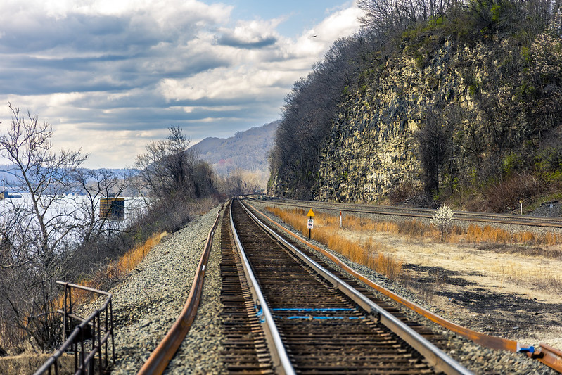
Along the Ohio River, and this shot is from the northern side of the waterbody, there’s a pretty expansive series of rail tracks which are used by the Norfolk Southern outfit. I was hoping to catch a shot of a passing train when I was here, but no such luck was on offer. Have to get myself one of those railfan scanner radios one of these days, so I know if something interesting is coming my way.
Go west, old man.
Back with all that, at this – your Newtown Pentacle, tomorrow.
“follow” me on Twitter- @newtownpentacle
Buy a book!
“In the Shadows at Newtown Creek,” an 88 page softcover 8.5×11 magazine format photo book by Mitch Waxman, is now on sale at blurb.com for $30.
Damn, that’s one heck of a Dam
Wednesday

– photo by Mitch Waxman
The United States Army Corps of Engineers’ Montgomery Locks and Dam is one of the giant honking pieces of infrastructure an inquisitive wanderer might encounter in Pennsylvania’s Beaver County, while scuttling along the Ohio River. This isn’t too far from the currently undefended border of the states of Ohio and Pennsylvania, where the now infamous East Palestine locomotive derailment occurred. Up the Ohio towards Pittsburgh, you’ve got the Shell Cracker Plant mentioned on Monday and just down the river, there’s a nuclear power plant.
USACE has a page at their site which describes their operations on the Ohio in this region, which can be accessed here. To summarize – this monster dam and gate system was built between 1932 and 1936, and it replaced three earlier (late 19th century) wooden locks and dams.

– photo by Mitch Waxman
The mechanics of what this facility does involves mechanical lift gates and spillways which regulate the amount of river flowing through them. This outfit works in concert with other lock and dam installations to allow the Corps to maintain the “Pittsburgh Pool” and other navigational areas, but it isn’t intended to control the flooding issues which had previously bedeviled the region. A lot of Federal cash went into not having anything like the disastrous St. Patrick’s Day flood of 1936 happen again, but there’s a completely different set of infrastructure prophylactics in place for that sort of work. This is one of the many things that I’m reading up on at the moment.
See? I’ve learned, and am learning, new things since moving here.

– photo by Mitch Waxman
On the opposite shore, USACE has two lock systems, one for large ships and commercial vessels and another for smaller private or pleasure craft ones. The commercial lock is 600 feet long by 110 wide, and the secondary is 360 feet long by 56 feet wide. It’s costs about $6 million a year to keep this machine running, or so I’m informed.
The Ohio River is just under 1,000 miles long. It starts in Pittsburgh and eventually intersects with the Mississippi River at the southern tip of the State of Illinois. A river of cities, industry, and commerce – and a de facto extension of the Mason Dixon line between north and south – the westward flowing Ohio is also considered to be the most polluted waterway in the United States over the course of its length. It actually edges out Newtown Creek on pollution, but unlike my beloved creek, the Ohio is a source of drinking water for many of the communities found on its banks – parts of Pittsburgh, or West Virginia’s Wheeling for instance. The Ohio is thought to be the sixth oldest river in North America, and several civilizations have depended upon the ancestral waterway for its riches, including our own.

– photo by Mitch Waxman
Having followed the aforementioned group of fishermen whom I had noticed leaving a pickup for a trail towards the water, one soon found himself staring into the lift gates and spillways at the heart of the operation. I had prepared for my afternoon with a “full pack” camera bag and I had all of my toys and tools with me. These are all tripod shots with the lens wearing a 10 stop ND filter to slow down the scene and mellow out the visual distraction of water ripples and that sort of thing. Generally speaking, it was pretty bright out and these are 8-10 second captures.
When I’ve got a few extra bucks in my pocket, somewhere down the line, I’m planning on replacing my current set of old school screw on filters with the more modern magnetic snap on kind. So much easier to deal with, the magnet ones. You screw the receiver onto the lens and then just “click” the filter onto it. The screw on kind are dust collectors extraordinaire, are quite “fiddly,” and it is very, very easy to scratch your expensive lens with the exposed metal edge of the screw fitting on the thing. Yeah, I know, camera nerd stuff… sorry.

– photo by Mitch Waxman
The weather was definitely on my side for once, with temperatures in the low 50’s and a bright sky. It’s been a pretty warm winter here, but that’s also seen a lot of super cloudy days with dismal lighting. Back in NYC, this sort of atmospheric season would see me riding a lot of Subways out to distant stations and “shooting trains.” The subway system presents a series of horrific challenges, photography wise. Mastering that environment, which you’ll soon learn the rules of, is a fantastic exercise for learning how to work a camera.
One of the other things I’ve learned here in Pittsburgh is that when the skies are good, you take advantage of that. Pittsburgh is one of the cloudiest regions in the entire country, with something like 200 days of the year (on average) being cloudy or overcast. This is apparently caused by the shape of the terrain, which causes most storms to fly around or over Pittsburgh. Other surrounding communities less than an hour’s drive away will get walloped by snow or thunderstorms whereas in Pittsburgh itself you just get clouds and drizzle. Not a meteorologist, can’t tell you why, but it has something to do with being located in what’s considered “the foothills of the Appalachian Range.”
Where I was standing had signage indicating that this was a park, and in tune with that the thing that’s surprised this transplanted New Yorker just about everywhere I’ve visited – there was a Porta Potty available to the public to take care of business if the need arose. To a former New Yorker, this is acknowledgment of human biology is nepenthe.

– photo by Mitch Waxman
A humble narrator enjoyed a short chat with a young fellow working as a contractor for the Feds doing maintenance on the dam and its spillways. He described what sounded like an incredibly dangerous job freeing debris and mud from occluding the gate system, one which pays less an hour than a job working a cash register back in NYC. I headed back up the hill to the Mobile Oppression Platform, whereupon my gear was packed away and the camera settings returned to my ‘catch as catch can’ handheld settings, and away from the landscape and filter setup.
Tomorrow, something different at this – your Newtown Pentacle.
“follow” me on Twitter- @newtownpentacle
Buy a book!
“In the Shadows at Newtown Creek,” an 88 page softcover 8.5×11 magazine format photo book by Mitch Waxman, is now on sale at blurb.com for $30.
A place called Industry
Tuesday

– photo by Mitch Waxman
I admit it, it was the Shell Cracker Plant that drew me in, but it was seeing the nuclear plant’s cooling towers which made me happy while visiting Pennsylvania’s Beaver County. I’m semi confident in stating my outright and admitted guess that they’re a part of the Beaver Valley County Power Station. Guessing, as said, but there you are. First time in these parts. I think that I was in a place called Shippingport, after visiting another hamlet dubbed Industry.
I drove about the waterfront of the Ohio River for a little bit after getting a few shots of the Shell facility, doing my ‘lookie loo scoutie’ thing. A humble narrator probably looked pretty ‘sus’ to the locals while tooling along in the Mobile Oppression Platform and sticking the camera lens out the window every now and again, but there you go.

– photo by Mitch Waxman
There was a mill with a lot of people doing some sort of work within. Seemed like a metals business, from the overall shape of the place, but since I’m still trying to just understand where things are hereabouts… I wasn’t going to hang around and ask the hard hats what they were getting up to. There was something else nearby, which I had spotted while scrutinizing a Google map of the area, that I wanted to check out.
I had to drive through a residential town area to get there, but that wasn’t a problem. Really nice and neat little community, kind of lovely water front place with some houses that enjoyed Ohio River frontage property, dogs in yards, that sort of thing, and all framed up with the Nuclear Plant in the background. Seemed like a pretty nice place. I’d show you what it looked like, but I don’t take pictures of people’s houses for this blog because that would just get weird fast.
Factories, bridges, that sort of thing is ok by me. Houses? How’d you feel seeing some weirdo in a black raincoat pull up in a car that looks like a Star Wars Stormtrooper’s helmet right in front of your door, and start waving a camera around? Lock and load, right?
Weird. Fast.

– photo by Mitch Waxman
The United States Army Corps of Engineers’ Montgomery Locks and Dam, that’s what’s pictured above, and it’s found on the Ohio River. As I pulled up to this view, a group of fisherman type guys were piling out of a pickup and they filed down a hill to get to some opportune spot below. One followed their pathway, after finding a place to park the car. It’s Federal property, so I’m technically an owner with something like a 1/363,000,000th share of the thing. You too.
Parking in this sort of area isn’t about the difficulty of finding a spot to stick the car, instead it’s trying to find a spot where you know it’s legal or socially ok to do so. In some areas of Pittsburgh, it’s considered an affront to park in front of somebody’s abode if you don’t have any particular business with them or a direct neighbor. Google up “the parking chairs of Pittsburgh” if you want to know more about this sociological wrinkle.
I’ll tell you all about this dam tomorrow.
“follow” me on Twitter- @newtownpentacle
Buy a book!
“In the Shadows at Newtown Creek,” an 88 page softcover 8.5×11 magazine format photo book by Mitch Waxman, is now on sale at blurb.com for $30.
Lock and Dam too, Allegheny River
Tuesday
– photo by Mitch Waxman
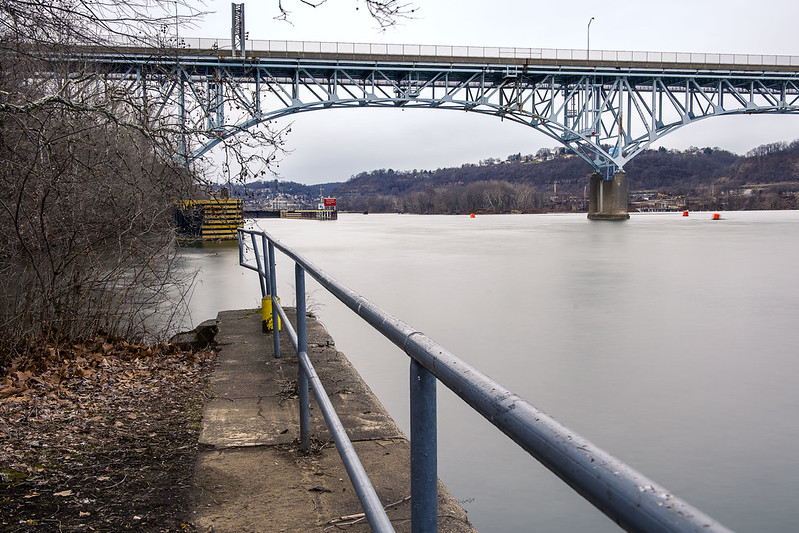
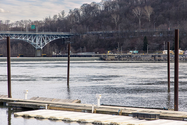
The 1932 vintage Allegheny River Lock and Dam No. 2 (aka Highland Park Lock and Dam) along the Allegheny River drew my interest recently. The St. Patrick’s day flood of 1936 in Pittsburgh, which is part of the same climatological event that drowned nearby Johnstown, resulted in a lot of Federal attention to the rivers surrounding Pittsburgh. The United States Army Corps of Engineers got busy planning a solution after the Flood Control Acts of 1936 and 1938 were passed by Congress. The USACE realized flood control over the Allegheny River after the Kinzua Dam was completed in 1965. Of course, they’ve got three rivers to worry about here (four, actually) and there’s similar USACE infrastructure found on both the Ohio and Monongahela Rivers.
It seems that the USACE design creates about 24 miles of level navigable water on the three rivers, which is referred to as the “Pittsburgh Pool,” and the water level is meant to be some 710 feet above sea level. When a ship navigates into this particular Allegheny River lock, it’s raised or lowered 11 feet from the pool’s altitude depending on direction. There’s a long series of these fixed crest dams and boat locks on the Allegheny River leading all the way back to the Kinzua Dam, which is on the New York side of Pennsylvania’s northern border.
Pennsylvania is wild, man.
– photo by Mitch Waxman
After becoming interested in this sort of infrastructural goodness, I began the usual scouring of Google maps’ satellite views for potential locations from which I could get a look at the thing in action and maybe even set up the tripod for a few “low and slows.”
That sounds bad, doesn’t it? I mean long exposure, tripod mounted landscape shots, not any of the things you could slot “low and slow” into. Aww, that sounds even worse…
“Highland Park Dam Overlook” is what it says this spot is called on Google maps, and after following a Google street view truck’s ride into the area, I decided that this would be the first of several nearby spots where I’d try to find some points of view and maybe the odd natural composition or two.

– photo by Mitch Waxman
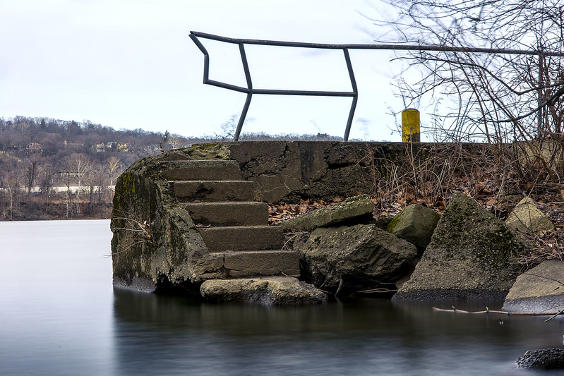
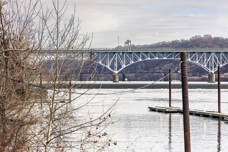
The furthest out into the water, and the closest clear shot of the Lock and Dam I could get near in this Overlook section, was literally the spot pictured above – on a chunk of what was probably 90 year old concrete sticking out into the Allegheny River. The 1937 vintage bridge in the shot is called the Highland Park Bridge.
I did walk down to the gates of the USACE compound which operates the machinery of the lock, but it was all chain link with barbed wire with security cameras there. I made a mental note to try and charm the pants off of whomever is in charge of this stuff and strive to get some future access for photos from them. I’ve done it before.

– photo by Mitch Waxman
I had to drive a bit of a circuitous route to hit my list of “POV’s,” and since something else that I wanted a look at was found along this route, I diverted away from my lock and dam fever for about an hour. More on that tomorrow.
One arrived at another previously remote scouted location for the point of view above after the diversion. That dark line in the water is a fixed crest dam, a concrete structure in the water column which introduces an 11 foot drop in elevation to the Allegheny River. The USACE maintains a minimum depth of nine feet for the Allegheny, it’s deeper in many places, but that’s a lot of water cascading about.
I had a couple of other locations marked down, including a few other potential points of view on the opposite shoreline. I hopped into the Mobile Oppression Platform and crossed the Highland Park Bridge, heading into the community of Sharpsburg.
– photo by Mitch Waxman
Somebody probably wasn’t supposed to be where he was, while shooting these last two shots. Saying that, the property definitely seemed to be out of business or abandoned, but the former occupants left their “no trespassing” signs behind. That’s my story. I pulled the MOP over, cracked out a couple of shots, and then moved on.
The scouting area I’ve been looking at and writing about, since relocating to Pennsylvania, forms a rough circle with circumference points no further than a 30 minute drive from HQ, which is located about 4.5 miles from Downtown Pittsburgh. Using HQ as the center of that circle, I’ve been exploring triangular “pizza slice” sections of the new surroundings, slice by slice. Nerd.
– photo by Mitch Waxman
I was too far away to get a decent shot of it, but right after this shot, a tug and barge appeared and began to navigate into the lock. Wow.
As mentioned, in yesterday’s post, we’ve had a run of wet and snowy weather here in Pittsburgh for the last week. I know this is shocking news for late January. All the shots you’re seeing in this week’s six picture posts were frenetically gathered in a single day. Whew!
More tomorrow, from the Paris of Appalachia, at your Newtown Pentacle.
“follow” me on Twitter- @newtownpentacle
Buy a book!
“In the Shadows at Newtown Creek,” an 88 page softcover 8.5×11 magazine format photo book by Mitch Waxman, is now on sale at blurb.com for $30.
faiths contrary
There’s always a one in seven chance that it’s Wednesday

– photo by Mitch Waxman
So – you’ve got the NYC Ferry and the Staten Island Ferry, as well as the Hudson River NY Waterways ferries – what are you waiting for, an invitation? Get out on the water in the fresh air, bring a camera, and catch some sun. NYC Ferry can (and I’ve pulled this one off, but it requires a bit of planning) get you from the South Bronx to Rockaway for $2.75 if you time it correctly. Soundview is the Bronx line, and it carries passengers up the west channel of the East River and through Hells Gate (Triborough Bridge, Astoria Park, Hell Hate Bridge) and then past the Brother Islands and Rikers Island and berths just across the water from College Point.
The Astoria line incorporates Manhattan’s East 90th street, then stops at Roosevelt Island, Hunters Point North in LIC, Manhattan’s 34th street, the Brooklyn Navy Yard, and then Manhattan’s Pier 11 at the foot of Wall Street. From there you can transfer to another line or head over to the Staten Island Ferry.

– photo by Mitch Waxman
The South Brooklyn line stops at Corlears Hook on Manhattan’s Lower East Side, then Pier 11, then heads across the water to the foot of Brooklyn’s Fulton Street. From there it stops on either side of Atlantic Basin, the southern one (inside the basin itself) allows egress to Red Hook nearby the Brooklyn Passenger Ship terminal. Then it goes to Sunset Park’s Brooklyn Army Terminal and then all the way to Bay Ridge. There’s also an East River line which goes to Pier 11, 34th street, and Hunters Point South in LIC. I haven’t ridden the Lower East Side line, so I can’t speak intelligently about it. Supposedly, the next series of expansions will include Coney Island Creek and Staten Island, and the rumor is that Hudson side stops are coming too.
As a note, this isn’t paid content or anything, I’m just a fan. I find that getting on a boat and riding around the archipelago is a curative for bad moods and that being outside is generally good for one’s health. The best way to understand the NYC archipelago is from the water.

– photo by Mitch Waxman
That’s the Feds. Driftmaster is a United States Army Corps of Engineers harbor maintenance vessel. They scoop flotsam and jetsam out of the water using that prominent crane, and other gizmos they have onboard.
More tomorrow at this – your Newtown Pentacle.
Speaking of navigational channel maintenance… what are you doing on August 7th? I’ll be conducting a WALKING TOUR OF LONG ISLAND CITY with my pal Geoff Cobb. Details and ticketing available here. Come with?
“follow” me on Twitter- @newtownpentacle
Buy a book!
“In the Shadows at Newtown Creek,” an 88 page softcover 8.5×11 magazine format photo book by Mitch Waxman, is now on sale at blurb.com for $30.


