Archive for August 2009
DUPBO… or Down Under The Pulaski Bridge Onramp

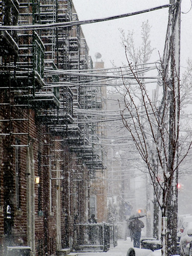
Pulaski Bridge from Newtown Creek – photo by Mitch Waxman
Context:
The Polish Lithuanian Commonwealth was a superpower in the 18th century world. From our post 20th century perspective, it is hard to conceive of Poland as being the strongman of Europe, but in land warfare they were as feared as the Tsarist Cossacks or Turk Janissaries– professional warriors- shock troops-who always got the job done.
Know that scene in the “return of the king” movie when Gandalf comes riding down leading the Rohan horsemen- Its Tolkien’s fantasy metaphor for what happened when the Poles arrived at the Siege of Vienna in 1683 under the leadership of John III Sobieski.

Looking up at the Pulaski Bridge from Long Island City – photo by Mitch Waxman
The formal and hereditary noble class of this military juggernaut was called the “szlachta“. Kasimierz Pulaski was a “szlachta“. His father was Starost (elder) of the area of Warka, and Kasimierz was sent to Warsaw at an early age for formal schooling and military training. He began his career as Page to the Duke of Courland, Carl Christian Joseph (of Saxony). The neighboring Russian empire dominated the Commonwealth and used its muscle to force the Polish Parliament to pass anything that the Tsar demanded. Pulaski, with others, formed a rebel group called the Bar Confederation which fought and won against the Russians- even succeeding in drawing them into a protracted war with the Ottoman Empire in 1768.

illustration from wikipedia

Pulaski Bridge and Newtown Creek – photo by Mitch Waxman
This strategy backfired as victory in the conflict allowed Russia to assume control over Ukraine, the Crimean Khanate, and the Caucasus from the already deteriorating power of Istanbul. The Turks allied themselves with the Bar Federation, and Russia with Great Britain. Pulsaki’s rebellion was broken by the betrayal of the King of Poland in the end, and Pulaski developed an enmity toward the English crown for its role in his country’s destruction and subjugation.

Looking north at Pulaski Bridge Tower over Newtown Creek, Queens side – photo by Mitch Waxman
The term for their cause that the Bar Federation coined was the “Golden Liberty“. Exiled from Poland with a charge of attempted Regicide, no country in Europe would accept Pulaski as a citizen. Until word of his plight reached a certain printer from Philadelphia who was living in Paris.

Looking north at Pulaski Bridge Tower from Newtown Creek, Queens side – photo by Mitch Waxman
History:
Over in North America a letter arrived from the Continent addressed to General Washington, one sent by his longtime colleague, the printer turned diplomat named Benjamin Franklin. In it Pulaski is introduced “as renowned throughout Europe for the courage and bravery he displayed in defense of his country’s freedom”. Accepting the recommendations of Franklin, the American Augustus invited Pulaski to join the cause, and offered him a chance at vengeance upon the British allies of his mortal enemies- the Russians.
Pulaski declard “I came here, where freedom is being defended, to serve it, and to live or die for it.”.

Jaws of Newtown Creek, Pulaski Bridge – photo by Mitch Waxman
At the Battle of Brandywine, Pulaski’s quick thinking and battlefield hardened experience saved Washington from defeat and death. Elevated to Brigadier General of the Cavalry, Pulaski used his own fortune to arm his men when Congress was slow in funding them. He is credited as being the father of the American Cavalry, and was instrumental in creating the system of practice drilling, training disciplines, and martial customs which have long been a distinction of the American Cavalry ever since.

Looking north at Pulaski Bridge Tower from Newtown Creek, Queens side – photo by Mitch Waxman
At the Siege of Savannah in 1779, Pulaski was hit by grapeshot and died of his wounds. There is debate over his resting place, but I favor the notion that he was buried at sea (just for the romance), but those in the know believe him to lie in Savannah, Georgia. In 2007, the US Senate got around to declaring Kasimierz Pulaski a citizen of the United States, but the bill still needs to pass the in House of Representatives and be signed by the President to become official.

Looking north at Pulaski Bridge Tower from Newtown Creek, Queens side – photo by Mitch Waxman
So, to celebrate this swashbuckling prince of Poland, who was instrumental in the transformation of the Colonial Army from a peasant brigade to an army that could fight the British, New York City named a bridge over Newtown Creek after him.
Just The Facts:
A bascule drawbridge of paralell counterweight design, the Pulaski Bridge was overseen by New York City Commissioner of Public Works Frederick Zurmuhlen, and the general contractor was the Horn Construction Company, with steel and expertise supplied by Bethlehem Steel. It opened in September of 1954 at a cost of $9,664,446.25- a reconstruction of the bridge in 1994 cost $40 million. It carries six lanes of vehicular traffic, and is a primary link between north Brooklyn and western Queens.

Looking west at Pulaski Bridge Tower from Newtown Creek, Queens side – photo by Mitch Waxman
It is the first bridge one encounters when entering the Newtown Creek, and it is oriented on a north south vector over the aqueous surface. It connects fabled Greenpoint in Brooklyn to the tangle and enigma of Long Island City in Queens. McGuinness Boulevard approaches the bridge from the south and Eleventh Street from the north. It has two 10.5m roadways divided by a concrete median barrier. It also carries a 2.7m pedestrian sidewalk. The bridge provides a channel with a horizontal clearance of 45.7m and a vertical clearance of 11.9m in the closed position at MHW and 13m MLW.
In this late 1940’s map at trainsarefun.com, the old Vernon Avenue Bridge is still in place, and the Pulaski is still under construction.
also-found this for sale on ebay, no affiliation

ad for Bethlehem Steel, 1953

Looking south at Pulaski Bridge Tower from Borden Avenue, Queens side – photo by Mitch Waxman
On the Queens side, approach from Borden Avenue. In previous posts, I might admonish that you will be crossing the very active grade level LIRR rail tracks leading to the Hunters Point station, warn you that you are walking by a group of very paranoid Port Authority cops working security at the Midtown Tunnel, or mention that it’s a busy truck route with multiple blind corners and virtually no sidewalk…
But- I wouldn’t want anyone to think that Long Island City’s industrial quarters are dangerous or anything…

Pulaski Bridge staircase – photo by Mitch Waxman
There are only seven available colors approved for bridges to be painted with in the City of New York, which are defined by the Public Design Commission as Deep Cool Red, Federal Blue, George Washington Bridge Gray, Aluminum Green, Pulaski Red, Munsell Gray or Dark Green.
Its sort of obvious what color Pulaski Red is.

Pulaski Bridge staircase – photo by Mitch Waxman
An Opinion:
I make it a point of not touching the Pulaski Bridge with anything other than the soles of my shoes. There is a thriving colony of pestilential fowl living in its rafters, and they delight in painting the bridge according to their own fecund taste. I also make it a point of walking through wet grass and puddles on my way back home to the noble hills of Astoria.

Looking north at Pulaski Bridge Tower from Newtown Creek, Queens side – photo by Mitch Waxman
Observations:
The Bridge has similar staircases at either side of the Newtown Creek, which allow access to the combined pedestrian walkway and bicycle lane. Looking due north, one sees Big Allis, The Queensboro bridge, and the toll plaza of the Midtown Tunnel. This pathway also offers commanding views of Manhattan due west.

“Stitched” Panorama of New York CIty from Pulaski Bridge over Newtown Creek, Queens side – photo by Mitch Waxman
Problematic encounters between speeding bicyclists and pedestrians have become a common experience for Newtownicans on this walkway. The visible affair is obviously in need of remedy, before a collision results in tragedy.

Pulaski Bridge, NYC Marathon 2009, corner of Jackson ave. and 49th ave. -photo by Mitch Waxman
Incidentally, the Pulaski Bridge is the 13.1 mile point in the New York Marathon, for which it is closed to vehicular traffic annually. This shot is from 2008.

Looking north from Pulaski Bridge, Queens side – photo by Mitch Waxman
Looking down, on the Queens side. The area under the bridge is used as a parking lot by the employees of area businesses, like FreshDIrect on Borden Avenue- whose operation is located directly eastward on the shore of the Newtown Creek.

Looking southeast from Pulaski Bridge, Queens side – photo by Mitch Waxman
There are always a heterogeneous collection of vehicles here, most simply parked- but some occupied by sleepers, others with romantic pairings of.. short acquaintance… ahem…
For an undetermined period of time, a man with no legs lived out of a van parked here, grilling his meals on a portable BBQ made from a steel can. I have to say that this area always fills me with an odd disquiet, a mocking feeling of being watched. Were I only to have some evidence to confirm these intuitions of my timorous nature…

Looking southwest from Pulaski Bridge, Queens side – photo by Mitch Waxman
To the West, an open air warehouse directly on the Newtown Creek bulkheads.

Looking west from Down Under the Pulaski Bridge Onramp, Queens side – photo by Mitch Waxman
At the water’s edge, one can gain a unique vantage point looking west toward Hunters Point.

Pulaski Bridge mooring, Queens side – photo by Mitch Waxman
The bridge’s works, from the Queens side. Notice the high tide sludge line on the moorings.

Pulaski Bridge mooring, Queens side – photo by Mitch Waxman
From this vantage, you can visualize the catwalks and ladders hidden within the superstructure of the bridge.

McGuinness Boulevard from Pulaski Bridge – photo by Mitch Waxman

Looking east from Down Under the Pulaski Bridge Onramp, Brooklyn side – photo by Mitch Waxman
The first thing you’ll notice is that this is where the DOT parks part of their truck fleet.
(the blown out section of the above photo is actually Paidge avenue, a left on which will carry you to the Newtown Creek Wastewater Treatment Facility Nature Walk)

Looking northwest from Down Under the Pulaski Bridge Onramp, Brooklyn side – photo by Mitch Waxman
Don’t forget to look the other way though, the view is a stunner.
Lords and ladies of Newtown, this has been the Newtown Pentacle introduction to DUPBO.
The Terracotta House, or… what is that?

New York Architectural Terra-Cotta Works, LIC -photo by Mitch Waxman
After an apocalyptic fire in 1886, the New York Architectural Terra-Cotta Works needed a new headquarters. One that befit its role as the preeminent manufacturer of architectural ceramics.
Built in 1892 as an office for the company that supplied terra-cotta for Carnegie Hall and the Ansonia Hotel, among others. The company went out of business in the 1930s, and the building became vacant. It was eventually bought in 1965 by Citibank. Its ruins can be found at 42-10 – 42-16 Vernon Avenue, across the street from the sumptuous hedonism of the newly opened Ravel Hotel, and next door to the venerable and recently feted span of the Queensboro Bridge. It was landmarked in 1982.
Two and one half stories, the structure is actually the front office of an industrial complex that was once surrounded by a 12 foot high wall of brick, which enclosed an open storage yard, a 5 story factory, and the kilnworks one would expect to find at such a large endeavor. Its satisfying design was crafted by Francis H. Kimball, architect of the celebrated Montauk Club in Brooklyn, and it is in the Tudor Revival Style.

New York Architectural Terra-Cotta Works, LIC -photo by Mitch Waxman
In preparation of the forthcoming Silvercup west project, the City of New York is compelled to conduct archaeological surveys by state law, seeking any evidence of pre-contact native american artitfacts. The area is a likely choice for such artifacts, as 10th street (800 ft or so from here) is the site of a former stream that ran though an elevated section of the marshy land typical of western Queens on its course to the East River. Nothing aboriginal was found, but the presence of large scale 19th century industry would have likely obliterated anything that might have been there.
Notable forebears of the Terra-Cotta works in this area were the Wallach Mansion, and the Long Island Farms Orphans Schoolhouse – a city owned 4 building asylum which burned to ash in 1847. Ravenswood was a neighborhood of fine riverside estates by the 1860’s, and Willy Wallach wanted the site for one of his own. By the late 1880’s, after the 800 pound gorilla came to Long Island City, an ideal place for locating an industrial operation was in this neighborhood of former mansions. The New York Architectural Terra-Cotta Works company purchased the Wallach estate and the neighboring Gottlieb estate.

New York Architectural Terra-Cotta Works, LIC -photo by Mitch Waxman
After the Terra-Cotta Works ended its incorporation, no doubt due to the seismic collapse of the national economy in 1932, the facilities enjoyed a diverse career under its owner- RIchard Dalton. First- it continued manufacture of terra cotta ornaments for use in New York City Parks (when Robert Moses was in charge) as the Eastern Terra Cotta Company, second- in 1950 it began to serve as a sorting center for plastic waste and the bailing of waste paper, and finally- in something curiously named “electronics operations”. Dalton used the building for his personal offices until he died in 1965, and his heirs sold the property to Citibank. Spared demolition in 1976, Terra-Cotta House was orphaned when the rest of the site was obliterated by a wrecking crew.
The building was landmarked in 1982, and is maintained by Citibank. The Silvercup West people plan on this being a charming feature for their development of the area. At the time of its glory, New York Architectural Terra-Cotta Works was the fourth largest employer in Long Island City. By the early 1970’s the place was abandoned and overgrown, forgotten by area residents. Local activists fought for and gained it landmark status in 1982.
Be sure to check out this FEIS link, they’ve got a photo on the last page of the place in its heyday.
Click here for the Silvercup West FEIS
Check out an old New York Times article on the Terracotta House here.
Keep cooly cool, boy…
sorry for a youtube video, just can’t resist
Astoria -Dec. 19, 2008-
30 degrees farenheit with 26 mph winds and 30 mph gusts, fog, .66 inches of rain and 4.4 inches of snow
– photo by Mitch Waxman
Newtown Pentacle headquarters, nestled in the torrid bosom of Astoria, positively swelters in the heat of a New York summer that seems to have finally arrived.
The streets outside teem with all the variegated shapes and sounds of mankind, and a tense mood can be sampled from the neighborhood gossips. Such annoyance and lamentation of the sort of extreme weather shifts that are so common to the New York area amongst my fellow citizenry puzzles me –
But those redoubtable stewards of the public good found at the City of New York’s Office of Emergency Management have posted the following remonstrations and timely advice:
from nyc.gov
The Heat Is On
The National Weather Service is predicting temperatures above 90 degrees this week. OEM reminds New Yorkers to take steps to stay cool:
- If you do not have an air conditioner, consider going to a public pool, air-conditioned store, mall, movie theater, library during the hottest part of the day.
- Drink fluids, particularly water, even if you do not feel thirsty. Avoid beverages containing alcohol, caffeine, or high amounts of sugar.
- Cool showers or baths may be helpful, but avoid extreme temperature changes as they can cause nausea or dizziness.
- Check on your neighbors, family, and friends, especially if they are seniors, young children, or people with special needs.

Astoria -Jan. 10, 2009 –
24 degrees farenheit with 18 mph winds and 22 mph gusts, fog, rain and 1.4 inches of snow
-photo by Mitch Waxman
Thanks to the turbulent skies of June and July- and the accompanying cooling effects of cloud cover, I have been spared the expense and infernal noise of an air conditioner in the little room I use as an office, here at the omphalos of my little world that “Our Lady of the Pentacle” and I maintain in a historic building. I fear that I must once again reach into my threadbare pockets and scrounge enough coin for the electronics salesman. My hope was that I might make it through the summer heat, just like we did during the Astoria Blackout of 2006.
Also from the OEM:
During the summer months, New Yorkers are especially vulnerable to heat-related hazards. On warm summer days, the city can be as much as 10 degrees warmer than its surrounding areas. The city’s infrastructure — largely made up of asphalt, concrete and metal — traps the heat. This is known as the “urban heat island” effect.
Heat waves are particularly dangerous for children, seniors, people with cardiovascular disease, and people taking psychotropic and other medications. In July and August of 2006, extreme heat waves gripped New York City, claiming 46 lives and disrupting power throughout pockets of the city. In France, a blistering heat wave in August 2003 left an estimated 15,000 dead, many of whom were seniors. In July 1995, a two-week long Chicago heat wave — which saw the heat index peak at 119°F — claimed 465 lives. More than half of the victims were 75 or older. According to the Centers for Disease Control, social isolation and the inability to care for oneself put a person at greater risk for heat-related illness.
A heat wave’s duration plays an important role in how people are affected. Studies show that a significant rise in heat-related illnesses occurs when excessive heat lasts for more than two days. Spending even two hours per day in air-conditioned spaces can significantly reduce the number of heat-related illnesses.

LIC -Jan. 18, 2009 –
22 degrees farenheit with 15mph winds, fog, and 2.5 inches of snow
-photo by Mitch Waxman
For a period of 14 days in 2006, Consolidated Edison lost control of their electrical grid in Astoria, Sunnyside, Woodside, and Long Island City. Riker’s Island had to engage its emergency generators.
On July 17th, the temperature at LaGuardia airport hit a high of 98 degrees farenheit with humidity at an uncomfortable 62 percent- it was 77 degrees at night. The weird thing was that our power was”on”, but browned out. We had one light in the entire apartment, in a darkened building. The entire block’s porch lanterns were ebbing on and off, and there were no street lights or traffic signals. Fire Engines roared back and forth across the area, as underground switches and cables ignited spontaneously. Subway service was knocked out as well. Here’s what NYTimes had to say.

LIC, Newtown Creek -Jan. 24, 2009 –
18 degrees farenheit with 26 mph winds and 33 mph gusts
-photo by Mitch Waxman
In front of St. Joe’s on 31st avenue (which is, incidentally, just across the street from the modern day Karate studio that once served as set piece for “Sonny’s Bar” in the Robert Deniro/Chazz Palminteri movie “A Bronx Tale“) a car parked over an electrical access hole was set alight when its underground works immolated and consequently exploded. On 46th street, between 34th and Broadway a pyrotechnic show was observed from a series of manholes, and a queer jiggling movement was detectable in the overhead wires that carry the current into the neat rows of picture perfect homes that epitomize this part of the Newtown Pentacle.
Here’s what ConEd was forced into doing.

Manhattan -Mar. 2, 2009 –
18 degrees farenheit with 35 mph winds, fog, and 5.2 inches of snow
-photo by Mitch Waxman
Atypically, for the duration of the 2006 outage, my preoccupation was getting to my air conditioned Manhattan office early and then staying late. Special joy was had in a refrigerated room which held an eccentric and overly complex mechanism for producing “press proofs” and its accompanying bank of always malfunctioning servers, producers of volcanic heat which could only operate in a room whose temperatures were 60 degrees farenheit or lower. The room had a tile floor and I would just lay down on it, allowing my body heat to dissipate as if into the fine marble of a tomb, that week in July of 2006.
bonus- here’s a little comic short I drew during the astoria blackout of 2006.
Greenpoint Avenue Bridge
A structure only a mother could love, the pugnacious span is also known as the J.J. Byrne Memorial Bridge.

From Review Avenue -photo by Mitch Waxman
Viewed from the street 0n Review Avenue, the Greenpoint avenue Bridge spans the Newtown Creek from Long Island City, Queens to Greenpoint, Brooklyn.
In Queens, Greenpoint avenue passes by Calvary Cemetery and changes its name to Roosevelt Avenue after it crosses Queens Blvd.
In Brooklyn, it remains Greenpoint Ave. all the way to the East River.
If it continued across the East River, it would intersect Manhattan at (the nonexistent) corner of 19th street and Avenue D. It’s 2.2 kilometers, or 1.37 miles from the mouth of the Newtown Creek at Hunters Point.

From the water on Newtown Creek -photo by Mitch Waxman
A note about the photos from the water-
On September 18th of 2004, the Newtown Creek Alliance and the Working Harbor Committee joined forces and chartered a cruise up the Newtown Creek. Onboard was a heterogeneous collection of experts. Amongst their number were scholars, researchers, photographers, environmentalists, historians- even the pale enthusiast know as the Hermetic Hungarian was present. This is an annual event, and we are just weeks away from the 2009 trip. Prior arrangements ensured that the drawbridges of Newtown Creek would open for us, and the redoubtable bridge operator performed his craft admirably.
from the DOT website:
The Greenpoint Avenue Bridge is a double-leaf trunnion bascule, with 21.3m wide leaves. This bridge is a steel girder structure with a filled grid deck. The bridge provides a channel with a horizontal clearance of 45.4m and in the closed position a vertical clearance of 7.9m at MHW and 9.4m at MLW. The bridge structure carries a four-lane two-way vehicular roadway with a 1.2m striped median and sidewalks on either side. The roadway width is 8.6m and the sidewalks are 4.0m and 3.7m for the north and south sidewalk respectively. The approach roadways are narrower than the bridge roadway. The west approach and east approach roadways are 17.1m (including 1.4m center median) and 11.9m respectively.

From the water on Newtown Creek -photo by Mitch Waxman
The Blissville Bridge was built in 1850, (and as an advertising freelancer- I can relate to this) and William H. McDonough, a civil engineer, had encountered difficulties getting paid by the folks on the Queens side after the job was done.
Neziah Bliss is the fellow for whom the surrounding community on the Queens side was named (part of this community was razed and became Calvary Cemetery) and the man credited with building it. A shipbuilder from Greenpoint, Bliss had married into the Meserole family and had aspirations of greatness. He established ferry service to Manhattan from Greenpoint, bought up the Queens side of the Newtown Creek, created Franklin Avenue as a turnpike, and had the Blissville Bridge built to extend Greenpoint Avenue into Queens.
Bliss was a self made man who left his native Connecticut at the tender age of 20. His fortune was assured when he made the acquaintance of the accomplished steam engineer, Robert Fulton. Through professional association with the older man, Bliss soon felt confident to start his own career.
Of course, Forgotten-NY has been everywhere, everythere, and everyhere.
also from the DOT website:
The first bridge on this site, a drawbridge known as the Blissville, was built in the 1850’s. It was succeeded by three other bridges before a new one was completed in March 1900 at a cost of $58,519. That bridge received extensive repairs after a fire in 1919 damaged parts of the center pier fender, the southerly abutment, and the superstructure. Until that time, the bridge had also carried tracks of the Long Island Rail Road. The current bridge was built in 1987.

From the water on Newtown Creek -photo by Mitch Waxman
Bliss traveled the national circuit as a consultant on the dangerous and vital new technology of steam, making many industrialist friends, including future presidents. In 1827, Bliss returned to New York City and worked at the Novelty Iron works in Manhattan on East 12th street on the East River. Makers of maritime engines, he enjoyed great success, and coveted both Greenpoint and the Newtown Creek from his offices. He would do it better, creating a planned community of neat streets and open skylines, utterly unlike the smokey and dark alleys of industrial Manhattan. Bliss lobbied the U.S. Navy to move the Brooklyn Navy Yard to Newtown Creek, but his failure to convince the admirals only set him to resolute and magnified ambitions.
He established a shipyard in Greenpoint, and had enjoyed considerable success. Enough to expand his operations along the Newtown Creek, and to set up a transportation network to bring in supplies. It was during the land transactions securing the real estate for these expanded works that he met Mary A. Meserole. Marrying into the ancient Meserole clan gave him social status and political access. He soon redesigned Greenpoint and with a partner- the President of Union College– Eliaphalet Nott, founded Blissville on the utopian model of a planned industrial community.
S. Berliner the III has an excellent LIRR site here, with maps of the LIRR tacks that once crossed here.
For a broader perspective, check out the astounding Frank J. Dmuchowski’s Greenpoint Perspective

From the water on Newtown Creek -photo by Mitch Waxman
In 1926, J.J. Byrne worked for Joseph A. Guider, Borough President of Brooklyn.
In 1926, the Borough Presidents held a vote on the New York City Board of Estimate, giving their political machines an effective stranglehold on the allocation of funds to municipal projects. A delicately balanced political machine, this grand experiment called the City of Greater New York spread a lot of money around the boroughs in those early days, just to keep everyone happy with the new arrangement. Don’t forget, the B.P would have been the Mayor of Brooklyn, or Queens were it not for the consolidation.
Gatekeepers to a flood of city money designated to build jails and firehouses and bridges, and all sorts of public buildings – especially schools, courthouses, and hospitals- that could be sited in favored alderman’s wards- the Borough Presidents became important and powerful men. Their political organizations extended from the street corner to City Hall and all the way to Albany. Not implying, exactly, that Guider and Byrne were bad guys, or exemplars of corruption- but they ran BROOKLYN in the 1920’s. BROOKLYN.
Guider was a democrat, as was Byrne. Guider had previously represented Brooklyn’s 11th district in the New York State Assembly from 1896-1900- serving during the Greater New York consolidation efforts. By 1922, he was the Public Works Commissioner of Brooklyn during the reign of B.P. Edward Riegelman, and commanded the princely salary of $7,500 a year as compensation.
Elected in 1925 as Borough President, Joseph A. Guider is remembered for civil building projects, playing a role in the founding of what would become Brooklyn College, and keeping the Brooklyn Bridge toll free for Bicycles. The future Mayor Jimmy Walker eulogized him as “a conscientious and useful public servant’. He’s also remembered for dying in office.

From the water on Newtown Creek -photo by Mitch Waxman
Borough President Guider died midterm in 1926 from a burst appendix at 1:30 AM on September 22, 1926 at the Skene Sanitarium of 759 President Street, so the Brooklyn Commissioner of Public Works- J.J. Byrne– was naturally the first choice for succession by the Aldermen.
Byrne was a Brooklyn native, a son of immigrants who hailed from “Irishtown” near the modern Brooklyn Navy Yard. He finished grammar school, but went no further, and was reknowned for his trained singing voice. J.J. Byrne completed the term of Guider, and was reelected in 1929 as B.P. in his own right. Byrne is remembered as having extended both the sewer system and the number of Brooklyn Libraries, and for pushing along several long municipal boondoggle projects on the Tammany list- such as the Central Courts Building .
Borough President J.J. Byrne died in office as well- in 1930. Doctors report his death as being caused by a failure of function in the kidneys.
Guider and Byrne were both creatures of the notorious Brooklyn Democratic Party Boss John H. McCooey.
J.J. Byrne was McCooey’s Brother in Law. McCoeey was known as “Tammany’s Uncle John, in Brooklyn”.

John H. McCooey – photo from wikipedia.
This is another one of him throwing out the first pitch of the 1932 season.
Check out this great NYTimes modern article on Byrne, with a picture of J.J. Byrne
from the nyc.gov website:
James J. Byrne was born April 8, 1863 on Water Street in Brooklyn to Irish immigrant parents. He was raised near the Brooklyn Navy Yard in an area known as Irishtown. He completed St. James parochial school with an eighth grade diploma, and worked in the machinist trade. He joined the Building Department as a clerk in 1898.
He was appointed chief clerk of the Bureau of Public Buildings (1907-08) and later Brooklyn Commissioner of Public Works (1924-26). When Borough President Joseph A. Guider died in office in September 1926, Byrne was selected to complete the term. He was elected in 1929. Byrne died in office on March 14, 1930, after a period of declining health. His wife’s brother-in-law was John H. McCooey, Democratic Leader of Kings County.

From Review Avenue -photo by Mitch Waxman
Mayor Michael Bloomberg recently announced his intentions to devote $6 million of New York’s share of the Federal Stimulus Package funds to repair and rehabilitate the Bridge.
In 1919, it would have been the place to watch and later participate in a spectacular and auspicious conflagration at Standard Oil. This structure was constructed in 1987, replacing the 1900 model which was damaged by a different fire and partially rebuilt under the administrations of Guider and Byrne. In 1922, there was debate over whether the Blissville Bridge should be replaced by a tunnel under Newtown Creek, but the prohibitive cost made a bridge seem the best choice..

From the water on Newtown Creek -photo by Mitch Waxman
From the water, one can observe the intricate works of the lift mechanisms. Gargantuan, they suggest the handiwork of some storied cyclops trying to please his half lame master. The double-leaf trunnion bascule design, precisely euclidean in design and inspired function, is powered by gargantuan electrical motors. Activated by a manned post, the structure is actually quite active but a shadow of its former self, as ship traffic on the Newtown Creek once exceeded that of the Mississippi.

From the water on Newtown Creek -photo by Mitch Waxman
The areas of Greenpoint and Long Island City touched by the Bridge are odd and lonely places.
In Brooklyn, there is the Newtown Creek Sewage Treatment Plant and the Miller Building. If one walks down to the end of the bridge and turns right on Greenpoint Avenue, they shall find themselves in an isolated and dark spot over a particularly dirty bend in the path of the Newtown Creek. Its deserted and a little scary down there, so a left onto Kingsland Avenue will take you past the Oil Spill remediation efforts Exxon diligently shepherds.
On the Long Island City side, Review Avenue takes you to venerable Calvary, and Greenpoint Avenue out to bucolic Sunnyside, and Van Dam to the frenetic Queens Plaza. But- there are two service roads on the Long Island City side, that lead down to the water. Both are labeled Greenpoint Avenue.
The Coast Guard says:
The Greenpoint Avenue Bridge, at mile 1.3, across the Newtown Creek between Brooklyn and Queens has a vertical clearance of 26 feet at mean high water and 31 feet at mean low water…
Transalt.com describes the Bridge thusly:
A small drawbridge across the English Kills, with horrible surfaces. The roadway is a grating, and the sidewalk is some nasty broken-up rubber. No stairs, though.

From the JJ Byrne Memorial Bridge, aka Greenpoint Avenue Bridge -photo by Mitch Waxman
As I’m wont to remind you, dear readers, bring ID with you when you go to these places. By NY State law, you must produce ID when requested by a Policeman. I mention this, because despite the abyssmal, and possibly prosecutable laxity of security in this area- this is a pretty vital area and you SHOULD be challenged by security in this place. Also, ID may help to identify your body if you are not extremely careful of trucks and trains down here, or if some other remnant of New York’s past finds you out.
You won’t be, however.
Your biggest hassle may come from the guys working on their cars, or from hired security at the fencelines.

Railroad Avenue, From down under the JJ Byrne Memorial Bridge, aka Greenpoint Avenue Bridge- DUGABO -photo by Mitch Waxman
Both of the Greenpoint avenues terminate on Railroad Avenue. There’s some cool 19th century stuff down the street, especially where the pavement stops, but I was uncertain of whether I was trespassing or not so I turned back in accordance with my inner timidity. The road vestigially follows the tracks for a few hundred yards and it appears on many old maps.

From the JJ Byrne Memorial Bridge, aka Greenpoint Avenue Bridge -photo by Mitch Waxman
On the west side, LIRR tracks, at grade level, weave tenebrously toward Manhattan. That’s the LIRR Bliss tower in the lower right.

From the JJ Byrne Memorial Bridge, aka Greenpoint Avenue Bridge -photo by Mitch Waxman
On the East, storage for street signs.

From the JJ Byrne Memorial Bridge, aka Greenpoint Avenue Bridge -photo by Mitch Waxman
To the south, the spires of Greenpoint.
reflections of…
check these out at ebay.com. I’m posting this on 8/08/09, and the auction says its got four days to go. I can never afford to buy these, but one of you people reading this might be rich and can. If you do, please let me publish them… please?
I’ve got no affiliation with these folks by the way, this isn’t an ad or anything.

For offer, a rare archival collection of original photographs! Fresh from a prominent estate in Upstate, NY. Vintage, Old, Original – NOT a Reproduction – Guaranteed !!
22 photos, numbered in the photo. Some say Complete Electrical Installation, Newtown Creek B/T by Friedman Electric Company. Looks like they are building an oil or gasoline / gas company. Shows trucks, cars, men working, buildings, advertising signs, etc. Nice views! Others have writing on back with the same location, dated Jan., 1931, with names identifying people in the photos. Include Max Bresnick, J. McMasters, H. Decker, Walter Buck, William Besterman. 17 photos are 8 x 10 inches. 5 are 6 x 8 inches. In good condition overall. Some photos do have light damage at edges, a few have creases. Please see photos below for more information. NOTE: Photos look better than shown below! If you collect 20th century Americana history, American / United States of America photography, occupation, industry, advertisement ad, etc. this is a treasure you will not see again! Add this to your image or paper / ephemera collection. Important genealogy research importance too. Combine shipping on multiple bid wins! Insurance is extra, international s/h is more. No reserve. Good luck bidding.


