Archive for September 2009
Panoramic Notes
Note: the scope of the Newtown Creek often obviates the need for some detail, and a broader perspective than the narrow lensing and shallow observations which are the usual totality of my capabilities. Experimenting with the photomerge feature in photoshop has allowed me to capture interesting horizontal images which are “stitched” together from multiple photographs. The results are not perfect, and have clear seams. Of course, the elaborate falsehoods I perpetrate for the advertising world, and the commensurate skills I’ve developed in “retouching”, would allow me to obscure such defects. I don’t want to, though.
Accordingly, I always specify these sorts of highly processed imagery as “a stitched panorama”, so as to inform the viewer of anomalous artifacts of the digital imaging process. Experience has taught me that stitching raw files as opposed to JPEG will create a smoother transition. The first image, of the Grand Street Bridge from onboard a moving ship, is all jpeg. The second, of the East Channel of the Newtown Creek, looking west toward Manhattan Skyline, Kosciuzcko Bridge, Calvary Cemetery- is all raw.
Also, I linked these 2 images to their GIANT incarnations- actual pixels. They’re big, but you can see some serious detail in them.

Grand St. Bridge from Newtown Creek – photo by Mitch Waxman
Both of these are part of a post coming your way over the weekend, incidentally. Don’t mean to spoil it or anything, but as you may have guessed, DUGSBO cometh!!!

Newtown Creek from Grand St. Bridge- photo by Mitch Waxman
I once met a guy at some party in Williamsburg, he was a “freak” at a modern Coney Island funhouse in the early 90’s. An urban primitive, if you remember that scene. He was an early “political bicycle guy”, and had suffered a tremendous injury on the Grand Street Bridge in the late 80’s. A truck had come barreling over the shaky structure, which vibrated so tremendously that it displaced the fellow from his bicycle, and then a second truck drove over… his head. Not 2 minutes after I took the west facing panorama directly above, a city bus sped over the bridge doing at least 60mph on the way to a nearby bus depot. The violent quaking and groaning of the bridge, as it expressed the kinetic blow it just suffered, terrified one of my frequent companions, who feared that she would be thrown into the uncaring waters of the Newtown Creek, to join with those unknowable things that may lurk down there.
The bicycle man in Williamsburg was an odd fellow, to be sure, and claimed that the unique scars and severe depression on the back of his head were the end result of the event, and testament to the skill of his doctors and surgical staff. Our Lady of the Pentacle and I referred to him as “the guy who looks like a thumb” afterwards. I currently know a fellow in Astoria who claims to have lost his south Boston accent and speech pattern in a car accident.
DUMABO- Down under the Metropolitan Avenue Bridge Onramp
Click here to see a Google Map of the Metropolitan Avenue Bridge

Metropolitan Avenue Bridge – photo by Mitch Waxman
Once called the Masters’ Bridge, which carried cart and wagon across the 19th century’s Jamaica Turnpike, modernity knows this crossing over the English Kills as the Metropolitan Avenue Bridge.
It lurks on Metropolitan Avenue- between Vandervoort and Varick Avenues in East Williamsburg– Brooklyn. The bridge carries a two-way vehicular roadway with sidewalks, and is a double leaf bascule type bridge erected in 1931, rehabilitated and modernized in 1976, and it received several upgrades in 1992 and 2006.
When the Williamsburgh and Jamaica Turnpike Road was built during 1813-14, Stephen B. and Samuel MASTERS’ operated the Turnpike. under a lease for about twenty years, the toll gate stood near their mill and bridge. MASTERS’ Bridge is replaced by the Metropolitan Avenue Bridge on the old site. When the Brooklyn and Newtown Turnpike Road was built, the toll gate on the Jamaica Road was moved a little further east, to the point where the two roads crossed, Metropolitan and Flushing Avenues at East Williamsburgh in Queens County. The toll gate on the Brooklyn and Newtown Turnpike stood at the same period, about 1857, at Flushing and Knickerbocker Avenues.
Along Newtown Creek, at the junction of Metropolitan Avenue and Grand Street, was a white sandy beach, no building nearby but three boathouses. One of these was occupied by; Captain JACKSON, whose daughter was an expert swimmer, another by old Captain JAKE.
Lafayettes, eels & shedder crabs, were plentiful here and black mussels, used for bait could be picked up in any quantity.
from nyc.gov
Metropolitan Avenue Bridge Over English Kills
Metropolitan Avenue is a two-way local City street in Kings and Queens Counties. The number of lanes varies from two to four along the entire length of Metropolitan Avenue, which runs east-west and extends from River Street in the Southside section of Brooklyn to Jamaica Avenue in Queens. The bridge, the only one over English Kills, carries both Metropolitan Avenue and Grand Street. The bridge is situated between Vandervoort and Varick Avenues in the East Williamsburg section of Brooklyn. The Metropolitan Avenue Bridge is a double leaf bascule bridge with a span of 33.8 m. The general appearance of the bridge has been significantly changed since it was opened in 1931. The bridge provides a channel with a horizontal clearance of 26.2 m and a vertical clearance, in the closed position, of 3.0 m at MHW and 4.6 m at MLW. The bridge structure carries a four-lane two-way vehicular roadway with sidewalks on either side. The roadway width is 16.2 m and the sidewalks are 1.8 m. There are no height restrictions on the bridge.
After the City acquired Metropolitan Avenue from the Williamsburg and Jamaica Turnpike Road Company in 1872, the existing bridge was replaced by a swing bridge, which was also used by the Broadway Ferry and Metropolitan Avenue Railroad Company. Growth in the area made the bridge inadequate by the early 20th century. The current bridge was built in 1931. Modifications since then have included upgrading the mechanical and electrical systems and the replacement of deck, bridge rail, and fenders. The stringers were replaced and new stiffeners added in 1992.

Metropolitan Avenue Bridge Gears – photo by Mitch Waxman
It is, ultimately, the olfactory senses which will allow you to locate this structure amidst the industrial tangle that surrounds the English Kills. The heart of darkness, those waters which stand stagnant here return an oxygenation rate near or at zero, and can measure up to 10 degrees (celsius) higher in temperature than atmospheric conditions would predict. It is close to the bitter ending of the Newtown Creek watershed, the 3.4 mile mark, and only gelatinous horrors extend beyond the bridge- as English Kills winds into the wildest parts of legend haunted and anciently decadent Dutch Brooklyn.
from Brooklyn Eagle, April 30, 1885, courtesy junipercivic.com
Of the 600,000 residents of Brooklyn whose happy lot it is to live south of the little shallow basin that once was known as Bushwick Creek it is not an extravagant estimate to say that quite 85 percent of them have an indifferent idea of the all but putrescent stream, navigable and the center of important industrial interests, which bounds the northern limits of the city – a stream often mentioned in the Eagle under the name of Newtown Creek. There was a time, and that within the recollection of men of middle age, when this creek, the waters of which are today poisoned with the overflow of the waste which comes from the great chemical and other works that line its bank, was the home of fish of diverse forms and flavors. It was the resort of those who delighted in placatorial recreations and rarely were those who cast their lines in its pure waters disappointed of a goodly catch. It had peculiar attractions in this respect. While the creek for nearly three miles inland was a sort of paradise for fish of the ocean kind, above that point the brooks were inhabited by freshwater creatures, a tradition being held by many of the oldest inhabitants that trout of orthodox size and weight once sported in the cool pools that were formed by the outflowings of the springs near Tarquand’s school house. Now, nor for the past two decades, not an inhabitant of the deep is there to be found in it from source to estuary.
from nyc.gov
2-24029-0
|
Borough: |
Brooklyn |
Type: |
Bascule |
|
|
Telephone: |
(718) 388-0008 |
Location: |
Varick/Vandervoort |
|
|
Waterway: |
English Kill |
Miles from Mouth: |
3.4 |
|
|
Channels: |
1 |
Used by: |
Hwy |
|
|
Length: |
440′ |
Max. Span: |
111 |
|
|
Roadways: |
1 – 53′ 0″ |
Sidewalks: |
2 – 5′ 8″ |
|
|
Construction Cost: |
$634,634.86 |
Land Cost: |
Free |
|
|
Total Cost: |
$634,634.86 |
Date Opened: |
Mar. 27, 1933 |
|
Openings:
|
|
1988 |
1989 |
1990 |
1991 |
1992 |
1993 |
1994 |
1995 |
1996 |
1997 |
1998 |
|
Vessel Openings |
756 |
694 |
351 |
301 |
356 |
225 |
310 |
272 |
407 |
423 |
448 |
|
Test Openings |
38 |
82 |
160 |
72 |
154 |
215 |
141 |
131 |
96 |
72 |
140 |

Metropolitan Avenue Bridge Gears – photo by Mitch Waxman
Like the mighty Greenpoint Avenue (or J.J. Byrne Memorial Bridge) drawbridge before it, the titan gears of the bridge reveal themselves to the intrepid photographer when a hidden bascule mechanism is triggered by the manned post and the crossing blossoms open. Redoubtable, the tireless operators of the Newtown Creek bridges are always at the ready to allow a ship egress to the navigable extants of this fabled waterway that are the ruins of an untold and forgotten world. Once, there was more ship traffic in this place than on the Mississippi.
from New York Construction.com
The four-lane Metropolitan Avenue Bridge over the English Kills, an industrial waterway in Brooklyn’s East Williamsburg neighborhood, carries 36,000 cars and trucks daily. Meanwhile, maritime traffic on the waterway below calls for opening the span once a day on average, though during winter months, when ships laden with heating oil are steaming up and down the English Kills, the span opens multiple times each day. The existing 1931 span had replaced another bridge on the site dating to the 19th Century.

Metropolitan Avenue Bridge – photo by Mitch Waxman
People live down along the shoreline here, men with sin pitted faces that wear disgusting expressions indicating unknowable implications. Pitiful, they seem happy, with conveniences such as BBQ’s and collections of flyblown consumer goods cast off by the other spheres of existential reality surrounding them. One can often observe flocks of the higher orders of the avian specie who have mistaken the waters of English Kills for some welcome harbor- a respite from their migratory journeys.
from The History of Long Island, from Its Discovery and Settlement to the Present … By Benjamin Franklin Thompson, via google books
…The eastern portion of the town was known to the natives by the name of Wandowenock, while the western was called Mispat, or Maspeth, the latter being probably the appellation applied to a family or tribe of Indians, residing about the head of the creek, now called English Kills…

Metropolitan Avenue Bridge – photo by Mitch Waxman
Grafitti along the bulkheads of this place absolutely mystifies me. In this occluded and distant ward of the Newtown Pentacle, who will see the scrawled missives rendered at the risk of total immersion in those blackened and still depths with their clawing mud bottoms? The thought of such a baptismal submergence fills your humble narrator with an unspeakable dread at what might emerge from such a font.

Metropolitan Avenue Bridge – photo by Mitch Waxman
What effect does this place have on those outcasts and pariahs who maintain their semi nomadic lifestyle along the waterway (including myself, I suppose)? According to the EPA, several of the chemicals in abundant supply here are not just carcinogenic– but possibly mutagenic.
In 1917, this was the second busiest crossing between Brooklyn and Queens, with 10,944,525 crossings. That’s according to the NYTimes

Metropolitan Avenue Bridge – photo by Mitch Waxman
An air of desolation hangs about the place, looking west. The colour is here in great patches, an irridescent shade of putrefaction which burns wet-hot thoughts into your mind if stared at for too long, and which calls you back to it- time and again. Once, this prime fishing territory and pristine exemplar of the aboriginal Long Island environment supported a vast woodland community, but all that remains is the weedy growth that stabs through winter shattered cement.
A discussion of the topographic and geologic qualities at Newtown Creek, its tributaries, and the logic governing both the height of the various bridges, and the according dredged depth of the soft bottom from google books
From the Annual report of the Secretary of War- by United States. War Dept Volume 2, Part 1- 1893
…A revised estimate for the improvement was made in 1889 (Annual Report Chief of Engineers, 1889, Part I, p. 778), after the results obtained by the survey of January, 1889, bad been studied, and the cost was fixed at 8170,586.
In preparing the new project for the improvement it was kept in mind that the draft of vessels going above Vernon Avenue Bridge, where the most important wharves are located, was limited by the then available depth of water, and that many vessels had to be lightered at the bar to facilitate entrance at high tide, while those going out had to complete their cargoes after they reached the East Kiver. It was, therefore, thought best to provide for 21 feet from the entrance to Vernon Avenue Bridge, 18 feet to Central Oil Works, 15 feet to Queens County Oil Works, 12 feet to Nichols’s Chemical Works, and 10 feet to Metropolitan Avenue Bridge on both branches.
The bed of the creek below Veruon Avenue Bridge is variable in character below the plane of 18 feet, mean low water. Near the bar it is composed of sand or sand and clay mixed; but as the bridge is approached it g.’ows harder, like liardpan, and has large bowlders embedded in it. The creek has a very sluggish current, and where there are no bulkheads the deposits arising from the sewers and from the degradation of the soft and unstable banks cause obstructions to navigation, for which annual dredging is the only possible relief.
The river and harbor act of September 19,1890, appropriated $35,000 for continuing the improvement, and was applied throughout the main river, giving 21 feet at the entrance and 10 feet at the head of navigation. In the ” English Kills,” a northern branch of the river skirting Laurel Hill, a channel was made 700 feet long, 100 feet wide, and 10 feet deep, mean low water. The contract was closed August 24, 1891.

Metropolitan Avenue Bridge – photo by Mitch Waxman
The tributary of the Newtown Creek which the Metropolitan Avenue Bridge crosses is called English Kills. Right next door to the Dutch Kills, and the Dutch town of Boswijk (Bushwick) this name speaks of a forgotten world of internecine European political warfare and New World land grabbing. Here’s how it came by that designation:
from The Eastern District of Brooklyn By Eugene L. Armbruster, via google books
BEYOND THE NEWTOWN CREEK
In the olden times the lands on both sides of Newtown Creek were most intimately connected. County lines were unknown, the creeks were dividing lines between the several plantations, for the reason that lands near a creek were taken up in preference to others, and the creeks were used in place of roads to transport the produce of the farms to the river, and thus it was made possible to reach the fort on Manhattan Island.
The territory along the Newtown Creek, as far as “Old Calvary Cemetery” and along the East River to a point about where the river is now crossed by the Queensboro bridge and following the line of the bridge past the plaza, was known as Dutch Kills. On the other side of Old Calvary was a settlement of men from New England and, therefore, named English Kills. The Dutch Kills and the English Kills, as well as the rest of the out-plantations along the East River, were settlements politically independent of each other and subject only to the Director-General and Council at Manhattan Island, but became some time later parts of the town of Newtown.
Here’s why it’s called English Kills, from bklyn-genealogy-info.com
HISTORY OF QUEENS COUNTY with illustrations, Portraits & Sketches of Prominent Families and Individuals.
New York: W.W. Munsell & Co.; 1882.
Captain Richard Betts, whose public services appear for fifty years on every page of Newtown’s history, came in 1648 to New England, but soon after to Newtown, where he acquired great influence. In the revolution of 1663 he bore a zealous part, and after the conquest of New Netherlands’ by the English was a member from Newtown of the provincial Assembly held at Hempstead in 1665. In 1678 he was commissioned high sheriff of “Yorkshire upon Long Island,” and he retained the position until 1681. He became a bitter opponent to Director Pieter Stuyvesant and the little town of Bushwick, which he had founded. Under leave from the governor the English settlers had planted their town, but were refused the usual patent, and in 1656 Richard Betts administered a severe blow to Stuyvesant by purchasing the land for himself and 55 associates, from the red men, at the rate of one shilling per acre. The total cost amounted to £68 16s. 4d., which, with the sum of £76 9s. paid to the sachems Pomwaukon and Rowerowestco, extinguished the Indian title to Newtown. For a long series of years Betts was a magistrate. During this time he was more than once a member of the high court of assize, then the supreme power in the province. He became an extensive landholder at the English Kills. His residence was here, in what is still known as “the old Betts house.”
It is further said that here within sight of his bedroom he dug his own grave, in his 100th year, and from the former to the latter he was carried in 1713. No headstone marks the grave, but its absence may be accounted for by the fact that his sons had become Quakers and abjured headstones. The old house which we may enter by lifting the wrought iron latch of heavy construction, worn by the hands of many generations; the polished flags around the old deep well, where the soldiers were wont to wash down their rations, are still as the British left them on their last march through Maspeth. This house is but one of several most ancient farm houses still carefully preserved for their antiquity, on the old Newtown road, between Calvary Cemetery and Maurice avenue. These venerable companions have witnessed many changes, and now enjoy a green old age, respected by the community in which they stand.
For more on the Betts family, click here.

Metropolitan Avenue Bridge – photo by Mitch Waxman
Walking up Metropolitan Avenue, whose sidewalks are balustrated against the oncoming traffic, one sees the Bridge house- an uninspiring box clinging precipitously to the marshy shoreline. Heavy traffic is found on Metropolitan Avenue, and odd characters can be observed loping along in a characteristic New York “gangsta lean“. These men are area workers, vagrants, and neverdowells who can be seen lounging in crumbling doorways, around storefront churches or convenience shops, or seen congregating in tight circles down weed choked alleyways- which betray the characteristic aroma of… well, I did say weed choked. I’ve never had a negative encounter down here, but a sense of being out of one’s element does emerge.
from walknyc.org
The Metropolitan Avenue Bridge is in East Williamsburg and carries substantial bicycle commuter traffic, mostly of people living in the neighborhood going to and from work, but also of this writer (from home in Park Slope to work in College Point). This has merging and diverging traffic (Metropolitan Avenue and Grand Street) at either end and rough pavement at the east end. There is ample room for a bicycle lane in both directions. This and repaving the approaches, especially at the east end, is a worthwhile project for T.A.

Metropolitan Avenue Bridge – photo by Mitch Waxman
The water quality here is awful, in my observation. Stagnant and debased, even the aeration project based across the bridge, with its massive techology and modern scientific approaches, can only alleviate the surface of the pollution problems here, at the English Kills.
The City of New York has plans for this area. Check out page 29 of this PDF
DEP proposes to construct a 9 million gallon CSO storage facility to improve water quality by reducing the CSO discharged into the English Kills during rain storms when the CSO exceeds the capacity of the combined sewers. When this occurs, the CSO would be bypassed to the storage facility. At the end of the rain event the CSO would flow by gravity or be pumped back to the sewer system to be conveyed to the Newtown Creek Water Pollution Control Plant (WPCP) for treatment. This system was recommended by the Newtown Creek Water Quality Facility Planning Project (WQFP), a study that was part of the Citywide Combined Sewer Overflow abatement program.

Metropolitan Avenue Bridge – photo by Mitch Waxman
The aeration project is in its second phase. The third and fourth are the most important- and most expensive. The ultimate villain of the Newtown Creek is New York City. The sewer system, a byzantine and somewhat archaic collection of pipes and brick lined tunnels, drains directly into the estuarine water. Since the natural tributaries which once fed fresh water and caused “flow” were cemented over by the burgeoning metropolii surrounding it, the only “flow” received in this river of tears is runoff wastewater and raw sewage.
In 2006, the firm of Edwards and Kelcey won an award for completing their work early, here in Newtown…
Best of 2006 Award of Merit in the Bridge Category – Presented by New York Construction Magazine to Edwards and Kelcey for design services rendered in the rehabilitation of the Metropolitan Avenue Bridge over the English Kills in Brooklyn, NY. The Award recognizes that the $41 million project was completed a year ahead of the anticipated completion date despite the fact that the rehabilitation work was performed on a working bascule bridge carrying 36,000 cars and trucks daily.

Metropolitan Avenue Bridge – photo by Mitch Waxman
Our Lady of the Pentacle, in her infinite sadness, has heard me designate the following as “The Hundred Year Plan”. For more than a century, the logical course of action for “fixing” the Newtown Creek has been articulated in the form of the “Flushing Canal” or alternately “Flushing Tunnel”. By connecting the Newtown Creek to Flushing Bay via terraforming and aquascaping, a “Flow” would be established (and then combined with sediment dredging)- and the tidal actions of East River and Flushing Bay would sweep it clean. The combined waterway – a grand canal- would offer Queens and Brooklyn a vastly altered and exponentially richer central corridor- neighborhoods which are currently isolated, squalid, and typified by neglect and decay.
This is the theory, and the prevailing solution to the issues surrounding the watershed favored by those hierophantic experts consulted for advice and guidance by this Newtown Pentacle.
from hydroqual.com
A slideshow presentation detailing the plan for aeration (manifested in the surrounding photos) of the English Kills, dating from 2003, can be found here.

Metropolitan Avenue Bridge – photo by Mitch Waxman
The City of New York has further plans for this area. Check out page 30 of this PDF
DEP is proposing to construct two Air Blower Buildings for in-stream Aeration Facilities along the East Branch of English Kills and Dutch Kills. The Aeration Facilities were recommended by the Newtown Creek WQFP project to improve water quality in the Upper English Kills by increasing the dissolved oxygen concentration of the bottom waters. The project will include installation of a diffuser along the bottom of the East Branch of English Kills and Dutch Kills. Blowers housed in the buildings along the shoreline will supply air to the diffuser system.

Metropolitan Avenue Bridge – photo by Mitch Waxman
But, as always, things at Newtown Creek stay the same.
Check out this view of English Kills from 1934, courtesy of NY Public Library

Metropolitan Avenue Bridge – photo by Mitch Waxman
Industries will come and go, and great populations will spring up to service them. The work will go, and the communities will wither.

Metropolitan Avenue Bridge – photo by Mitch Waxman
Politicians will arise and attempt to appease those who stay behind. Bread and circuses, but the grand scale and endless possibilities of earlier days will remain just out of reach.

Metropolitan Avenue Bridge – photo by Mitch Waxman
Just beyond the west side of the bridge, the bulkheads lead back to the Newtown Creek proper, a larger waterway and industrial complex of which English Kills is but a tributary.

Metropolitan Avenue Bridge – photo by Mitch Waxman
Here you can see the “Black Mayonnaise”- a toxic combination of raw sewage, petroleum, and coal tar bubbling to the surface from subaqueous sediments- disturbed by the spinning of a ships propellors.

Newtown Creek Bulkheads – photo by Mitch Waxman
Head west, back along the English Kills, and you’ll be back at the Newtown Creek, quite near the former Mussel Island.
from epa.gov
Newtown Creek is a part of the New York – New Jersey Harbor Estuary that forms the northernmost border between the New York City boroughs of Brooklyn and Queens. In the mid 1800s, the area adjacent to the 3.8 mile Newtown Creek was one of the busiest hubs of industrial activity in New York City. More than 50 refineries were located along its banks, including oil refineries, petrochemical plants, fertilizer and glue factories, sawmills, and lumber and coal yards. The creek was crowded with commercial vessels, including large boats bringing in raw materials and fuel and taking out oil, chemicals and metals. In addition to the industrial pollution that resulted from all of this activity, the city began dumping raw sewage directly into the water in 1856. During World War II, the creek was one of the busiest ports in the nation. Currently, factories and facilities still operate along the creek. Various contaminated sites along the creek have contributed to the contamination at Newtown Creek. Today, as a result of its industrial history, including countless spills, Newtown Creek is one of the nation’s most polluted waterways.
Various sediment and surface water samples have been taken along the creek. Pesticides, metals, PCBs, and volatile organic compounds (VOCs), which are potentially harmful contaminants that can easily evaporate into the air, have been detected at the creek.
In the early 1990s, New York State declared that Newtown Creek was not meeting water quality standards under the Clean Water Act. Since then, a number of government sponsored cleanups of the creek have taken place. The New York City Department of Environmental Protection has sampled sediment and surface water at a number of locations along the creek since 1980. In 2009, EPA will further sample the sediment throughout the length of Newtown Creek and its tributaries. The samples will be analyzed for a wide range of industrial contaminants. EPA will use the data collected to define the nature of the environmental problems associated with Newtown Creek as a whole.
Weird Synchronicity
As it turns out, one of the interesting places in LIC that I was preparing a post about has experienced one of those massive conflagrations that seem to have afflicted relict properties all around the Newtown Creek for much of its history. I just uploaded, literally last night, a bunch of photos of 50-09 27th street- which burned down while the photos were in transit. The news reports are listing it as 50-10 27th street, but the address on its door is 50-09 .
I’ve mentioned this place before.
in a post on Dutch Kills
A fantastic series of abandoned industrial buildings are on the left. Photograph quickly, Newtownicans,these are being torn to shreds by those dastardly developers right now.
And, its at the eastern end of the “Empty Corridor“

– photo by Mitch Waxman

– photo by Mitch Waxman

– photo by Mitch Waxman

– photo by Mitch Waxman
Via Queenscrap
From Fox 5:
![[buildingfire.JPG]](http://1.bp.blogspot.com/_kulnm8Gjhh8/SqZATSj77tI/AAAAAAAAPIY/ubHZdH_jpQo/s400/buildingfire.JPG)
A massive fire is burning in a two-story warehouse in Long Island City, Queens.
The flames broke out at around 6 a.m. at 50-10 27th Street and 50th Avenue.
Giant plumes of smoke from the blaze are covering the western side of the Long Island Expressway just before the Queens Midtown Tunnel.
Expect delays of at least 25 minutes on the Expressway.
NY Traffic Authority Ines Rosales recommends drivers in the area take he 59th Street Bridge or get off on the Queens Boulevard and take the Queens Borough Bridge.
There are no reports of injuries.
and from ny1.com
A three-alarm fire in Long Island City was brought under control just after 9 this morning, but not until after it caused major congestion on the Long Island Expressway.
The fire broke out just before 6 o’clock inside an empty warehouse at 50th Avenue and 27th Street, just below the LIE.
The smoke reduced visibility on the roadway and briefly forced its closure.
Fire officials say the heat from the fire was intense, forcing firefighters to fight the flames from the outside of the building.
“We originally sent people in, but it was deemed unsafe, too much fire and a whole building that had been vacant,” said FDNY Deputy Chief Bob Maynes. “So we were worried about the safety of our firefighters.”
About 150 firefighters were needed to bring the fire under control.
The flames completely destroyed the facade of the building and took off most of the roof.
Three firefighters were treated for minor injuries.
Fire marshals have begun their investigation into the cause of the fire.

– photo by Mitch Waxman
and here it is in January of 2009

– photo by Mitch Waxman
Cruelty
Just a short one today. Still burnt out from the weekend’s tug boat races. Check out this video from tugster. I’ve got at least two major posts cooking right now.
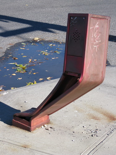
Project Firebox, 3350 – photo by Mitch Waxman
I realize and fully aspire to understand the harried mind of the metropolitan vehicular operator, but often wonder, how does one manage to ignore a 2 meter tall shiny red box until its too late?
The devastation endured by these silent sentinels is but one of the striking dichotomies one encounters when walking the shadows of concrete shrouded and legend haunted Newtown. To the benefit of this heterogeneous collection of guardian devices, which can raise titan armies of Fire and Police Departments at the touch of a button, their abuse must be remarked upon. We, as a community, must find some way to train drivers to notice the near presence of – a 6 foot tall gleaming metallic object with reflective surfaces. Calculation of its relative proximity to their vehicles would surely follow suit.
This is Project Firebox.

Project Firebox, 8778 – photo by Mitch Waxman
This was on Hunters Point Avenue, opposite a mattress factory outlet store. This I understood. Simple kinetics, an impact, and subsidence. Fine.
from wikipedia
Alarm Boxes: The second most common method is by means of F.D.N.Y. alarm boxes in the street and in certain public buildings such as schools and hospitals as well as highways, bridges, etc. These consist of the following primarily two types. The first is mechanical boxes, also commonly called pull-boxes or telegraph boxes in which a spring-wound mechanism alternately opens and closes an electrical circuit thereby rendering a coded number linked to the specific location of the box. Until the advent of the STARFIRE Computer-Assisted Dispatch System (CAD), dispatchers had to physically count the taps from mechanical boxes when they were received in the central offices. Today, a “Box Alarm Readout System” (B.A.R.S.) display handles that aspect of the job. The second type is the “Emergency Reporting System” (E.R.S.) boxes that are equipped with buttons to notify either FDNY or NYPD, allowing either department’s dispatcher to have direct voice communication with a reporting party. E.R.S. boxes began to replace mechanical boxes in many areas of the City beginning in the 1970s.

Project Firebox, 6368 – photo by Mitch Waxman
Down near Newtown Creek, this abandoned car was resting on this firebox for nearly a year, but this is a deserted little cul de sac near a hundred year old train station and the site of a long vanished bridge.
A pretty nice history of FDNY alarm boxes at google books

Project Firebox, 4477 – photo by Mitch Waxman
Where Astoria ends, and Dutch Kills begins, near Northern Blvd. Notice that it’s bent OUT, against the traffic.
Hey, somebody noticed the Newtown Pentacle
Check this out- an Astoria Times profile of Old Mitch and the Newtown Pentacle.
Big Newtown shoutout to reporter Jeremy Walsh.


