Archive for June 2012
eery pinnacle
– photo by Mitch Waxman
Until you’ve had a flock of baby birds vomit on you, you haven’t really lived.
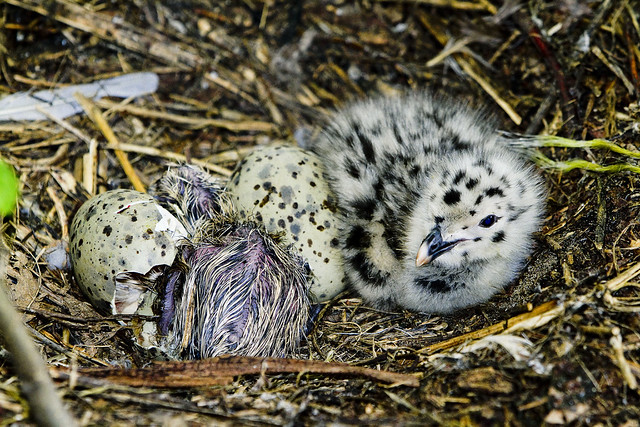
It seems that such regurgitation is just part of the daily grind here on South Brother island, an unassuming prominence found on the East River. Heavily wooded, the island is owned and managed by the Government(s) and it is usually “verboten” for primates to even visit.
from wikipedia
South Brother Island is one of a pair of small islands in the East River situated between the Bronx and Riker’s Island, New York City and is 7 acres (28,000 m2) in size. It is uninhabited. The other island, larger and better known, is North Brother Island. Until 1964, South Brother Island was part of Queens County, but it is now part of Bronx County. It had long been privately owned, but was purchased by the city in 2007. Together, the two Brother Islands, North and South, have a land area of 81,423 square meters, or 20.12 acres (81,400 m2).

– photo by Mitch Waxman
Your humble narrator managed to insert himself into a scientific survey of the breeding colony of Cormorants, Herons, and Egrets which thrive upon the riverine island. The island has been allowed to go feral, and is positively overrun by seabirds. Upon arriving there via a Zodiac boat, one of the fellows employed by the NRG (Natural Resources Group) of the NYC Parks Dept. asked me if I knew what poison ivy looked like.
Informing him that he should just assume my general ignorance about all things, he remarked- you’re standing in it.
from wikipedia
Toxicodendron radicans, better known as poison ivy (older synonyms are Rhus toxicodendron and Rhus radicans), is a poisonous North American plant that is well known for its production of urushiol, a clear liquid compound found within the sap of the plant that causes an itching, or sometimes painful rash in most people who touch it. The plant is not a true ivy (Hedera).
Poison ivy can be found growing in any of the following three forms:
- as a trailing vine that is 10–25 cm tall (4 to 10 inches)
- as a shrub up to 1.2 m tall (4 feet)
- as a climbing vine that grows on trees or some other support

– photo by Mitch Waxman
The party split into two groups, and the one I accompanied headed into the stand of trees which comprises the center of the island. Thick and overgrown, the darkness of the place was palpable, and a raucous chorus of bird calls was emanating from the canopy above. The mission was to count the number of nests installed (in this section by Cormorants) and whenever possible- to count the number of eggs and or hatchlings.
The other group was busy exploring Heron territory.
from wikipedia
The Black-crowned Night Heron (Nycticorax nycticorax), commonly abbreviated to just Night Heron in Eurasia, is a medium-sized heron found throughout a large part of the world, except in the coldest regions and Australasia (where replaced by the closely related Rufous Night Heron, with which it has hybridized in the area of contact).

– photo by Mitch Waxman
This was by no means an easy task, given the sort of terrain encountered.
Once- the Newtown Creek’s watershed would have resembled this scene, thought a humble narrator, when a half digested fragment of fish dropped out of the sky and bounced off my boonie hat. It was quickly explained to me that this was normal, expected, and part of their daily round. The floor of the place was a spongy mass of fallen branches, mulch, and guano.
An intense smell of ammonia forced me back to the beach a couple of times.
from wikipedia
Regurgitation is used by a number of species to feed their young. This is typically in circumstances where the young is at a fixed location and a parent must forage or hunt for food, especially under circumstances where the carriage of small prey would be subject to robbing by other predators or the whole prey is larger than can be carried to a den or nest. Some birds species also occasionally regurgitate pellets of indigestible matter such as bones and feathers. Penguins are known to regurgitate in order to feed their young ones.

– photo by Mitch Waxman
Shooting conditions were difficult, with dense foliage and few clearings. The humidity was nearly unbearable. The instructions I had received from the group leader indicated that I should dress in long sleeves, full length pants, and wear heavy boots.
Conditions on the island indeed demanded such cautions, but heat and humidity plus the aforementioned ensemble worn with a hat while carrying a camera bag and around six pounds of camera and lens made for an uncomfortable morning.
Karmic justice, I suppose, for all the complaining about being cold I subjected you to during the winter at this- your Newtown Pentacle.
this page at nysl.nysed.gov lists all the complaint departments in New York State
Complaint Departments
New York State government information and resources on Complaint Departments.
Consumer Information
WWW.NY.GOV – cick on “Complaints.
Attorney General’s Office
Complaints – Includes a section on “Complaints for Other Agencies” to help people contact the appropriate agency…

– photo by Mitch Waxman
It should be mentioned that I absolutely detest camping out, abhor hikes in the woods, and am- by definition- a City Boy. Nature wants to eat you, and will at the very first chance it gets. You might be disarmed by the coy attractions of these baby birds, but give them the chance and they’d rip you to shreds.
Then they’d vomit the bits back out onto the next guy who visits this island.
It did occur to me that this might be a safe haven in case of a zombie apocalypse, but the nearby North Brother Island would probably be a better choice. Seriously, I’m not just being paranoid, nature can be messed up, and given several recent headlines– might be time to start formulating a plan for upcoming Nights, Dawns, and Days.
from wikipedia
The bird family Phalacrocoracidae is represented by some 40 species of cormorants and shags. /ˈkɔrmərənt/ Several different classifications of the family have been proposed recently, and the number of genera is disputed.

– photo by Mitch Waxman
In the real world, of course, such fancies fall before the hard materialism of the empirical mindset, and this mission I was accompanying dwelt naught upon such extravagant thinking. They were doing the hard work of field science, collecting data and samples for later analysis. The South Brother Island was acquired by the Parks people in 2008 and the notion of dedicating the tiny island(s) as a refuge for seabirds is actually pretty darned cool.
from nycgovparks.org
In 2001, the City assigned Parks jurisdiction over the publicly-owned lands extending outward from the shores of South Brother Island. The island itself was owned by Hampton Scows, Inc. The recent acquisition of South Brother Island was directly negotiated and completed with approximately $2 million in funds allocated by Congressman Jose Serrano through NOAA’s Coastal and Estuarine Land Conservation Program.
The acquisition was executed by The Trust for Public Land on behalf of the recipients of the NOAA funding, The Wildlife Conservation Society and The Point Community Development Corporation. The Trust for Public Land then donated South Brother Island to Parks for public ownership, management, and natural resource protection.

– photo by Mitch Waxman
An interesting auditory effect was noticed, incidentally, which rendered the vocalizations of the avian multitudes into something akin to that which you would hear coming from a crowded lunchroom full of school kids. This blended with a syncopated call and response of what sounded like calisthenics PE over at Rikers Island, a short distance away.
Note- the island is strictly off limits (said status is zealously enforced by several of the different harbor officialdoms and gendarmes). I was the guest of a highly trained and dedicated crew who catechized me on the rules of the place and watched my every step to insure that no harm came to anything living here. It is illegal, in the extreme, to visit this place without prior approval from the authorities.
Despite my dripping sarcasm and good natured kvetching about the trip, the folks I was with are really fighting the good fight here, gathering data in difficult conditions in order to understand the breeding habits of endangered wildlife to foment the survival of said species in the harbor of New York.
check out this 2007 report from harborestuary.org, which contains data supplied by some of the folks on this trip, and is an earlier iteration of what they were up to just a few days ago.
Also:
June 16th, 2012- Newtown Creek Alliance Dutch Kills walk

– photo by Mitch Waxman
The Newtown Creek Alliance has asked that, in my official capacity as group historian, a tour be conducted on the 16th of June- a Saturday. This walk will follow the Dutch Kills tributary, and will include a couple of guest speakers from the Alliance itself, which will provide welcome relief for tour goers from listening to me rattle on about Michael Degnon, Patrick “Battle Ax” Gleason, and a bunch of bridges that no one has ever heard of.
for June 16th tickets, click here for the Newtown Creek Alliance ticketing page
June 23rd, 2012- Atlas Obscura Thirteen Steps around Dutch Kills walk

– photo by Mitch Waxman
Additionally- the “Obscura Day” Thirteen Steps around Dutch Kills tour proved that the efficacy and charms of the Newtown Creek’s least known tributary, with its myriad points of interest, could cause a large group to overlook my various inadequacies and failings. The folks at Atlas Obscura, which is a fantastic website worthy of your attentions (btw), have asked me to repeat the tour on the 23rd of June- also a Saturday.
for June 23rd tickets, click here for the Atlas Obscura ticketing page
June 30th, 2012- Working Harbor Committee Kill Van Kull walk

– photo by Mitch Waxman
My various interests out on the sixth borough, NY Harbor, have brought me into association with the Working Harbor Committee. A member of the group’s Steering Committee- I also serve as the “official” group photographer, am chairman and principal narrator of their annual Newtown Creek Boast Tour, and occasionally speak on the microphone during other tours (mainly the Brooklyn one). This year, the group has branched out into terrestrial explorations to compliment the intense and extant schedule of boat tours, and I’m going to be leading a Kill Van Kull walking tour that should be a lot of fun.
The Kill Van Kull, or tugboat alley as its known to we harbor rats, is a tidal strait that defines the border of Staten Island and New Jersey. A busy and highly industrialized waterfront, Working Harbor’s popular “Hidden Harbor – Newark Bay” boat tours provide water access to the Kill, but what is it like on the landward side?
Starting at the St. George Staten Island Ferry terminal, join WHC Steering Committee member Mitch Waxman for a walk up the Kill Van Kull via Staten Islands Richmond Terrace. You’ll encounter unrivaled views of the maritime traffic on the Kill itself, as well as the hidden past of the historic maritime communities which line it’s shores. Surprising and historic neighborhoods, an abandoned railway, and tales of prohibition era bootleggers await.
The tour will start at 11, sharp, and you must be on (at least) the 10:30 AM Staten Island Ferry to meet the group at St. George. Again, plan for transportation changes and unexpected weirdness to be revealed to you at MTA.info.
For June 30th tickets, click here for the Working Harbor Committee ticketing page
Walking Tours in June

– photo by Mitch Waxman
Despite my loathsome appearance, abhorrent personality, and an unwholesome nature which engenders disdain from strangers- the walking tours of the Newtown Creek Watershed I’ve been conducting have all proved to be quite popular and in fact- have sold out. There have been one or two that I’ve publicized, and a few that were privately organized.
Demand has dictated that an expanded schedule of these walks, albeit punctuated by my incessant prattle, be offered.
To wit:
June 16th, 2012- Newtown Creek Alliance Dutch Kills walk
– photo by Mitch Waxman
The Newtown Creek Alliance has asked that, in my official capacity as group historian, a tour be conducted on the 16th of June- a Saturday. This walk will follow the Dutch Kills tributary, and will include a couple of guest speakers from the Alliance itself, which will provide welcome relief for tour goers from listening to me rattle on about Michael Degnon, Patrick “Battle Ax” Gleason, and a bunch of bridges that no one has ever heard of.
for June 16th tickets, click here for the Newtown Creek Alliance ticketing page
June 23rd, 2012- Atlas Obscura Thirteen Steps around Dutch Kills walk
– photo by Mitch Waxman
Additionally- the “Obscura Day” Thirteen Steps around Dutch Kills tour proved that the efficacy and charms of the Newtown Creek’s least known tributary, with its myriad points of interest, could cause a large group to overlook my various inadequacies and failings. The folks at Atlas Obscura, which is a fantastic website worthy of your attentions (btw), have asked me to repeat the tour on the 23rd of June- also a Saturday.
for June 23rd tickets, click here for the Atlas Obscura ticketing page

– photo by Mitch Waxman
The tours will cover similar ground, but approach the subject from differing angles. Both share the same dire warnings about traffic and footwear and the “boiler plate” offer is included below. As a rule, walkups are allowed, but be warned- when the group get to a certain size, I’m forced to refuse additional participants.
Buying a ticket in advance is your best bet.
Join Newtown Creek Alliance Historian Mitch Waxman for an intense exploration of Newtown Creek’s Dutch Kills tributary — found less than one mile from the East River. Dutch Kills is home to four movable (and one fixed span) bridges, including one of only two retractile bridges remaining in New York City. Dutch Kills is considered to be the central artery of industrial Long Island City and is ringed with enormous factory buildings, titan rail yards — it’s where the industrial revolution actually happened. Bring your camera, as the tour will be revealing an incredible landscape along this section of the troubled Newtown Creek Watershed.
Be prepared: We’ll be encountering broken pavement, sometimes heavy truck traffic, and moving through a virtual urban desert as we cross the currently undefended border of Brooklyn and Queens. Dress and pack appropriately for hiking, closed toe shoes are highly recommended.
Bathroom opportunities will be found only at the start of the walk, which will be around three hours long and cover approximately three miles of ground.
Meetup – At the Albert E. Short Triangle park found at the corner of Jackson Avenue and 23rd Street in Long Island City, Queens. This is the Court Square MTA station, and served by the 7, G, and M lines. Additionally, the Q39 and B62 buses have nearby stops. Check MTA.info as ongoing construction at Queens Plaza often causes delays and interruptions.
Drivers, it would be wise to leave your vehicle in the vicinity of the Pulaski Bridge in either Greenpoint or Long Island City.
June 30th, 2012- Working Harbor Committee Kill Van Kull walk
– photo by Mitch Waxman
My various interests out on the sixth borough, NY Harbor, have brought me into association with the Working Harbor Committee. A member of the group’s Steering Committee- I also serve as the “official” group photographer, am chairman and principal narrator of their annual Newtown Creek Boat Tour, and occasionally speak on the microphone during other tours (mainly the Brooklyn one). This year, the group has branched out into terrestrial explorations to compliment the intense and extant schedule of boat tours, and I’m going to be leading a Kill Van Kull walking tour that should be a lot of fun.
The Kill Van Kull, or tugboat alley as its known to we harbor rats, is a tidal strait that defines the border of Staten Island and New Jersey. A busy and highly industrialized waterfront, Working Harbor’s popular “Hidden Harbor – Newark Bay” boat tours provide water access to the Kill, but what is it like on the landward side?
Starting at the St. George Staten Island Ferry terminal, join WHC Steering Committee member Mitch Waxman for a walk up the Kill Van Kull via Staten Islands Richmond Terrace. You’ll encounter unrivaled views of the maritime traffic on the Kill itself, as well as the hidden past of the maritime communities which line it’s shores. Surprising and historic neighborhoods, an abandoned railway, and tales of prohibition era bootleggers await.
The tour will start at 11, sharp, and you must be on (at least) the 10:30 AM Staten Island Ferry to meet the group at St. George. Again, plan for transportation changes and unexpected weirdness to be revealed to you at MTA.info.
For June 30th tickets, click here for the Working Harbor Committee ticketing page
tangible things

– photo by Mitch Waxman
Hanging around the East River side of Lower Manhattan recently, your humble narrator was elated to see the Bouchard Tug “Ellen S. Bouchard” transiting past Governors Island. Such prurient thrills are all that I’m still capable of getting excited about these days, so I whipped out the camera and started shooting.
Built in 1982, by Halter Marine of New Orleans, Louisiana (hull #1036) as the Ellen S. Bouchard for Bouchard Transportation of Melville, New York.

– photo by Mitch Waxman
That’s a fuel barge that the tug is managing, and odds would be good that it’s journey began on either the Kill Van Kull or the Port of Newark. It would be foolish to guess where it was headed, except to say that it will drop its cargo off at a distribution center for eventual disposition to end customers via tanker trucks.
From his first voyage at eleven years of age as a cabin boy on a sailing ship bound for China, Captain Bouchard knew that shipping would be his life. By 1915, he was the youngest tugboat captain in the Port of New York.

– photo by Mitch Waxman
The barge would be carrying something close to the equivalent capacity of fifty standard sized oil trucks, and was accordingly making its way through the narrow East River in a slow and deliberate fashion. Such caution is necessary, as an accidental allision or collision would spell disaster for both natural and unnatural features alike.
from wikipedia
Bouchard Transportation Co., Inc, based in Melville, New York, and founded in 1918, is primarily a family and employee-owned company that provides transportation and logistics services in U.S..

– photo by Mitch Waxman
There’s something about the sight of Tug passing under the Brooklyn Bridge that causes one to want to buy a slice of pizza or order a bagel with cream cheese and lox and complain about the Mayor or the Yankees. It’s just so “New York”.
from wikipedia
The tugboat is one symbol of New York. Along with its more famous icons of Lady Liberty, the Empire State Building, and the Brooklyn Bridge, the sturdy little tugs, once all steam powered, working quietly in the harbor became a sight in the city.
The first hull was the paddler tug Rufus W. King of 1828.
Not exactly Project Firebox, but…

– photo by Mitch Waxman
Op Sail 2012 coincided with the annual Fleet Week event this year, and the John J. Harvey fireboat was there to greet everyone to its home port. Storied, the Harvey is no fire alarm box of course, but I just really dig this shot. The odd lighting was caused by a hole in the clouds which magically appeared over the Hudson just as the event was kicking into high gear, which lends a cinematic quality to the image.
Cue “flight of the valkyries”.
The Blissville Oil Spill, update

– photo by Mitch Waxman
Queries were sent out to various parties about the status of the Blissville Oil Spill on the Newtown Creek, and this statement was received from the good folks at Riverkeeper:
“Riverkeeper is concerned about the apparent lack of maintenance of both the hard and absorbent booms that are supposed to be keeping oil from seeping into the Creek,” said Phillip Musegaas, Hudson River Program Director at Riverkeeper. “We take any oil pollution in the Hudson River and NY Harbor extremely seriously, and fully expect DEC and the site owner to do the same.”
As an admission, these shots were gathered on board the Riverkeeper patrol boat, whose Captain was gracious enough to consent to my request to get close to the Blissville site.

– photo by Mitch Waxman
The situation of the Northern Bank of the Newtown Creek, in Queens, was first commented on at this- your Newtown Pentacle- in the December of 2011 posting “An oil spill… in Queens“, and further views were presented in March of 2012 in “Blissville Update“.
Kate Zidar, executive director of the Newtown Creek Alliance (a group of which I am a member and for which I serve as historian) said:
“If we have learned anything from the Greenpoint Oil Spill it should be that seepage from the bulkhead can indicate a much larger issue for the adjacent neighborhood. We can’t claim ignorance of what the seepage at this Blissville Site could indicate. We need to understand the extent of this contamination and get the right mitigations in place ASAP.”

– photo by Mitch Waxman
It should be mentioned that private conversations with State and City officials have continued, but not too much seems to be happening. The investigation into the matter is seeking out culpable parties, and deciding on a course of action to follow. In their defense, the officialdom referred to above very well might be legally constrained from public comment at this point, so I’m willing to give them a pass.
For now.
Of course, while everyone is figuring out who to sue, oil is still seeping out into the water.

– photo by Mitch Waxman
It’s no secret that the short end of the stick, from a municipal point of view, is offered routinely to Queens (and the Bronx) by the powers that are. Neither is it a revelation that if this were an ongoing event on the Hudson River that everybody from the Mayor and Governor on down would be posing next to it and rendering funding to seal things up tight.
This is however- the Newtown Creek- and in particular on the side of the Creek where the borough motto should be “Welcome to Queens, now go fuck yourself”, and I said that.

– photo by Mitch Waxman
A recent posting at the Newtown Creek Alliance website, detailing what Riverkeeper’s patrol experienced during a rain event on the Newtown Creek, showed that these booms are easily swept out of position but “Welcome to Queens”. This event has been ongoing since mid 2011 but “Welcome to Queens”. Wells sunk at nearby properties already administered by environmental officials have revealed some seven feet of oil sitting over the water table, but “Welcome to Queens”.

– photo by Mitch Waxman
Lords and Ladies, how long is long enough for oil to be directly seeping into area waterways?
Look at what is happening on the surface here and ask yourself the familiar question- Who can guess, all there is, that might be buried down there?


