Archive for 2016
nail biting
A bit of Newtown Creek “now and then,” in today’s post.

– photo by Mitch Waxman
One has been at work on several subjects regarding that fabulously decadent cataract of Municpal neglect known to all as the Newtown Creek. It’s kind of big picture stuff, which requires a “long tail” of research on and about certain industries. You can’t understand something modern unless you understand its past, I always say.
For example – If I want to describe the Brooklyn Union Gas Manufactured Gas plant on Newtown Creek in Greenpoint (which is now the National Grid LNG plant on Varick), I need to possess an at least topical amount of knowledge regarding the history and technology of the 19th century Manufactured Gas Industry in New York City.
Actually, that’s not an example, it’s precisely the thing I’ve been working on – to develop an understanding of. Manufactured Gas Plants – or MGP’s as they’re known in the environmental community.
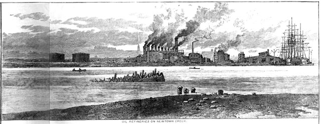
– from Harper’s Weekly, August 6th, 1881 (courtesy google books)
This sort of research always turns up a few surprises, and for an area like Newtown Creek – which is of truly national importance in the story of the second industrial revolution, but for which scant historical visual documentation exists – it’s sometimes pretty interesting. Harper’s Weekly was on quite a tear about my beloved Creek back in the summer of 1881, and presented a few illustrations of “the horror” interspersed with texts describing the oil drenched mud and stinking waters of Newtown Creek.
Here’s my speculation as to what I think we are seeing in these drawings. Educated guesses, btw., that’s all.
Nowadays, the outline of Newtown Creek barely resembles what it looked like back in 1881 – there used to be a couple of islands in the Maspeth Creek/Turning Basin area for instance – but there are few historical constancies with which you can reckon location around the creek when old photos or even illustrations are presented. The LIRR tracks are one of them, and another is the Maspeth Avenue Plank Road.
In the shot above, that pile of piles on the shoreline in the center of the shot? The smokestacks on the far shore? The gas holder tanks on the horizon?

– photo by Mitch Waxman
I think that the illustrator was sitting right about where I was last winter, at the shoreline intersection of industrial Maspeth’s 58th road with Newtown Creek, looking south west towards Greenpoint’s National Grid LNG site with the ruins of the Maspeth Avenue Plank Road directly in front of me.

– from Harper’s Weekly, August 6th, 1881 (courtesy google books)
The view above has railroad tracks in it, ones which follow a certain curve, one that has remained fundamentally the same since the LIRR laid them down in the late 1860’s. The tall smokestacks at the left of the shot are likely those of Phelps Dodge. The ones off in the distance are probably the Haberman rendering plant. Calvary cemetery would be to your left, and I have a sneaking suspicion that the illustrator set up his tripod at Penny Bridge – which is the modern day spot that Review Avenue transmogrifies into Laurel Hill Blvd.
That would put the illustrators point of view somewhere on the eastern side of Blissville, looking eastward towards Maspeth.

photo by Mitch Waxman
I’m of the belief that this is the same shoreline seen in the left side of the shot above, although my photo was captured from out in the middle of the channel while onboard a boat. The masonry on the lower right – or Brooklyn side – of the shot is what’s left of old Penny Bridge, and the 1939 model Penny Bridge (Kosciuszcko) is right where that divot on the shoreline is in the 1881 illustration from Harper’s Weekly. Phelps Dodge would have been found on the east side of the Kosciuszcko Bridge, and their property included the gray building with the blue stripe (the modern day Restaurant Depot).
Upcoming Events and Tours
Saturday, July 16, 11:15 a.m. – 12:45 p.m. –
FREE Newtown Creek Boat Tour,
with Waterfront Alliance (note- WA usually releases tix in batches).
Click here for more details.
Saturday, July 23, 11:00 a.m. – 1:00 p.m. –
Calvary Cemetery Walking tour,
with Brooklyn Brainery. Click here for more details.
Tuesday, July 26, 6:30 p.m. – 8:30 p.m. –
Glittering Realms Walking tour,
with NYC H2O. Click here for more details.
Wednesday, July 27, 1st trip – 4:50 p.m. 2nd trip – 6:50 p.m. –
2 Newtown Creek Boat Tours,
with Open House NY. Click here for more details.
“follow” me on Twitter- @newtownpentacle
abnormal gaps
Cool cars, Bushwick East Williamsburg edition.

– photo by Mitch Waxman
One was happily scuttling along recently, on his way to conduct a tour of the “Insalubrious Valley of the Newtown Creek,” when a charming old rust bucket was encountered on Grand Street not too far from the centuried swing bridge named for it. Unlike other “cool cars,” described at this – your Newtown Pentacle – I’m unable to describe make, model, year, or engine type as frankly – there wasn’t enough left of the thing to do so.

– photo by Mitch Waxman
I can tell you that it was a short bus, and that it still had an engine. It was missing a radiator and all the other parts which would attach around the engine, including the front end’s entire outer body.

– photo by Mitch Waxman
There were four tires on the thing, so that’s something. Additionally, inside the relatively intact passenger cabin, there seemed to be quite a few bits and bobs being stored. Looks like a handyman special to me.

– photo by Mitch Waxman
Just on the other side of the Newtown Creek in Maspeth – where Grand Street transmogrifies into Grand Avenue upon leaving Brooklyn and entering Queens – the short bus’s owner could probably find all the help he or she needs with the project at the MTA’s Grand Avenue depot.
A 600,000 square foot facility that’s four stories tall, the Grand Avenue depot can store 200 city buses at one time just on the first floor. It’s the second floor that would come in handy for the short bus’s owner, as one of the 27 maintenance bays up there would be just the thing to getting this “cool car” up and running again.
Upcoming Events and Tours
Tuesday, July 12, 7:00 p.m. – 10:00 p.m. –
LICHenge, with Atlas Obscura and the
Hunters Point Park Conservancy. Click here for more details.
Saturday, July 16, 11:15 a.m. – 12:45 p.m. –
FREE Newtown Creek Boat Tour,
with Waterfront Alliance (note- WA usually releases tix in batches).
Click here for more details.
Saturday, July 23, 11:00 a.m. – 1:00 p.m. –
Calvary Cemetery Walking tour,
with Brooklyn Brainery. Click here for more details.
Tuesday, July 26, 6:30 p.m. – 8:30 p.m. –
Glittering Realms Walking tour,
with NYC H2O. Click here for more details.
Wednesday, July 27, 1st trip – 4:50 p.m. 2nd trip – 6:50 p.m. –
2 Newtown Creek Boat Tours,
with Open House NY. Click here for more details.
“follow” me on Twitter- @newtownpentacle
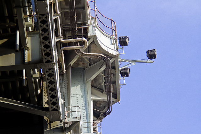
half smile
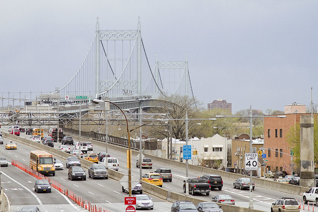
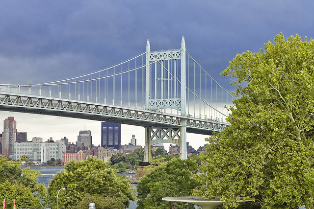
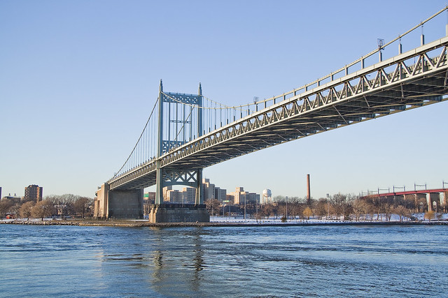
Happy Birthday, Triborough Bridge, you’re now an Octogenarian.
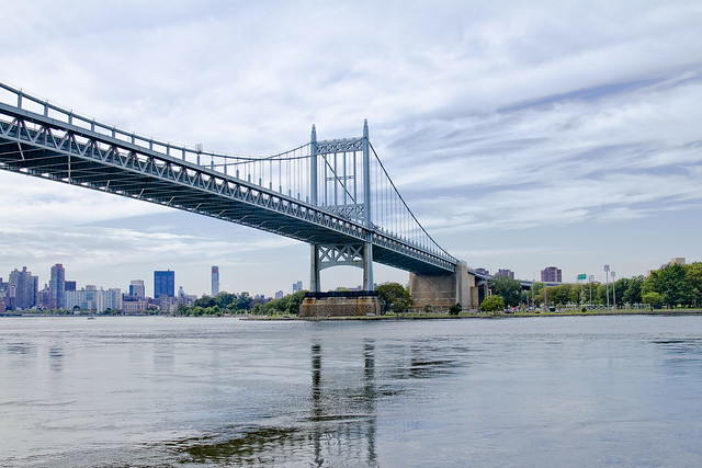
– photo by Mitch Waxman
Triborough Bridge, aka Robert F Kennedy Bridge, in Astoria, Queens opened on this day in 1936. It was 80 years ago today that Bob Moses taught the band to play, as it were. The bridge complex (there’s actually three spans that compose Triborough, pictured in today’s post is the suspension bridge section which connects to Astoria) was designed by the team of Othmar Amman and Aymar Embury ll. Construction on the thing began on the so called “Black Friday” of 1929 which signaled the beginning of the Great Depression.
from wikipedia
Construction began on Black Friday in 1929, but soon the Triborough project’s outlook began to look bleak. Othmar Ammann, who had collapsed the original design’s two-deck roadway into one, requiring lighter towers, and thus, lighter piers, saving $10 million on the towers alone, was enlisted again to help guide the project. Using New Deal money, it was resurrected in the early 1930s by Robert Moses, who created the Triborough Bridge Authority to fund, build and operate it. The completed structure was opened to traffic on July 11, 1936.
The total cost of the bridge was more than $60 million, one of the largest public works projects of the Great Depression, more expensive even than the Hoover Dam. The structure used concrete from factories from Maine to Mississippi. To make the formwork for pouring the concrete, a whole forest on the Pacific Coast was cut down.
– photo by Mitch Waxman
The national economic downturn caused progress on the project to grind to a halt, until Robert Moses took interest in the project and inserted himself. For the vast majority of living New Yorkers, all that we’ve ever known of this City is what Moses made of it. He gave our grandparents, parks, highways, and bridges – for awhile in the mid 20th century he was the de facto spokesman for “progress.” He destroyed entire neighborhoods and ruled his empire like a tyrant, as well. We all live in the “House of Moses.”
Moses wanted to build parkways and expressways, ultimately, and proposed to NY State that his high speed roads could serve as the approaches for the Triborough. His “Grand Central Parkway,” “Astoria Blvd.,” “East River Drive (now called FDR drive),” “Whitlock Avenue,” and “Eastern Blvd.” projects were all built simply to serve the needs of the automobile and feed traffic to Triboroughs Toll Booths. Due to the roads in Queens, Manhattan, and the Bronx, Triborough soon became the greatest machine for magnifying traffic that NYC that the world had ever seen. Traffic magnified year after year, and every single one of those vehicles had to pay tolls.
Moses, who helped author the modern constitution of NY State when he worked for Governor Al Smith, conducted business in the shadowy world of an “authority,” or public benefit corporation, which he had christened as the “Triborough Bridge Authority.” Moses literally wrote the laws governing such “authorities” and was able to game the system at every step. Today his authority is called the Triborough Bridge and Tunnel Authority, which was incorporated into the Metropolitan Transportation Authority (MTA) by Governor Nelson Rockefeller in 1968.
Today, Triborough is officially part of the MTA Bridges and Tunnels unit, but it still carries an obscene number of vehicles and collects shed loads of cash at those toll booths.
from wikipedia
Robert Moses (December 18, 1888 – July 29, 1981) was the “master builder” of mid-20th century New York City, Long Island, Rockland County, and Westchester County, New York. As the shaper of a modern city, he is sometimes compared to Baron Haussmann of Second Empire Paris, and is one of the most polarizing figures in the history of urban planning in the United States. He changed shorelines, built bridges, tunnels and roadways, and transformed neighborhoods forever. His decisions favoring highways over public transit helped create the modern suburbs of Long Island and influenced a generation of engineers, architects, and urban planners who spread his philosophies across the nation.
Never elected to public office, Moses was responsible for the creation and leadership of numerous public authorities which he could control without having to answer to the general public or to elected officials. It is due to Moses that there are a disproportionate number of public benefit corporations in New York state, which are the prime mode of infrastructure building and maintenance in New York, and are currently responsible for 90% of the state’s debt. As head of various authorities, he controlled millions in income from his projects’ revenue generation, such as tolls, and he had the power to issue bonds to borrow vast sums, allowing him to initiate new ventures with little or no approval from legislative bodies, bypassing the usual power of the purse as it normally functioned in the United States, and the cumbersome process of citizen comment on major public works.

– photo by Mitch Waxman
The jewel in Robert Moses’s crown was always mighty Triborough, and it was the center of his construction empire. Using the proceeds from the tolls on the bridge, and the unique freedom from the election cycle which Mayors and Governors were and are beholden to, the “authority” became a shadow government. Moses was able to wield incredible amounts of credit through the issuance of attractively priced municipal bonds guaranteed by Triborough’s millions in toll proceeds. This made him very popular with banking interests, and the huge amounts of cash and credit he had allowed Moses to build anything he wanted. Wherever he wanted.
Moses’s offices were on Randall’s Island, adjoining the counting rooms for the bridges tolls.
from wikipedia
Originally named the Triborough Bridge Authority, the authority was created in 1933 as a public-benefit corporation by the New York State Legislature. It was tasked with completing construction of the Robert F. Kennedy (Triborough) Bridge, which had been started by New York City in 1929 but had stalled due to the Great Depression.
Under the chairmanship of Robert Moses, the agency grew in a series of mergers with four other agencies:
- Henry Hudson Parkway Authority, in 1940
- Marine Parkway Authority, in 1940
- New York City Parkway Authority, in 1940
- New York City City Tunnel Authority, in 1946
With the last merger in 1946, the authority was renamed the Triborough Bridge and Tunnel Authority.
Generating millions of dollars in toll revenue annually, the TBTA easily became a powerful city agency as it was capable of funding large capital projects. From the 1940s-60s, the TBTA built the Battery Parking Garage, Jacob Riis Beach Parking Field, Coliseum Office Building and Exposition Center and East Side Airlines Terminal, as well as many parks in the city.
– photo by Mitch Waxman
There are few structures in NYC which are as staggering in scale as Triborough. According to Moses biographer Robert Caro’s definitive book “the Powerbroker” – “more than five thousand men would be working at the site, and these men would only be putting into place the materials furnished by the labor of many times five thousand men; before the Triborough Bridge was completed, its construction would have generated more than 31,000,000-man hours of work in 134 cities in twenty states.”
from mta.info
The bridge’s 3.5 miles of roadway include a suspension span to Queens, a vertical lift bridge to Harlem in Manhattan and a fixed truss bridge to the Bronx-all converging at a huge traffic junction on Randall’s Island. The Queens span is 1,380–feet long and has four lanes in either direction. It has a clearance of 135 feet above the river, high enough for ships to pass under. The Harlem River lift span (as it is commonly called) in Manhattan has three lanes in either direction and moves its center section up and down like an elevator to allow tall marine traffic to pass. The Bronx crossing has three lanes in either direction over its framework of steel beams that form interconnected triangles, making the structure light and strong.
– photo by Mitch Waxman
There is a school of thought out there which suggests that the heroic performance of American industry during the Second World War was due to the industrial orders which Moses placed during the 1930’s for materials needed to construct the bridge and its approaches. The steel factories of Pittsburgh, concrete factories up and down the East Coast of the United States, the railroads and cargo ships which carried the material into NYC – all served to put American industry back to work. Think about the corollary supply lines for everything that was needed to make it – coal, iron, coke etc. If Pearl Harbor would have occurred in a world in which there had been no Triborough project, it would have taken as long as two years to stoke the furnaces and rehire a work force to build the weapons of WW2.
– photo by Mitch Waxman
Triborough, as the name implies, touches down in three of the boroughs of NYC. It connects Manhattan, Bronx, and Queens. The East River suspension bridge spans a part of the river called Hells Gate. It also sits on one of the lesser islands of the archipelago of New York Harbor, Wards Island. Wards has been connected to its neighbor, Randall’s Island during the 20th century by landfill, but they used to be distinct land masses separated by a tidal strait.
Wards Island is kind of a weird place.
from wikipedia
After the war ended, Jaspar Ward and Bartholomew Ward took ownership of the island that later carried their surname. Although a small population had lived on the island since as early as the 17th century, the Ward brothers developed the island more heavily by building a cotton mill and building the first bridge to cross the East River in 1807, connecting the island with Manhattan at 114th Street.
The bridge, paid for by Bartholomew Ward and Philip Milledolar, was a wooden drawbridge. The bridge lasted until 1821, when it was destroyed in a storm.After the bridge was destroyed, the island was largely abandoned until 1840, when the island was transformed into a dumping ground for everything unwanted in New York City. Between 1840 and 1930 the island was used for:
- Burial of hundreds of thousands of bodies relocated from the Madison Square and Bryant Park graveyards.
- The State Emigrant Refuge, a hospital for sick and destitute immigrants, opened in 1847, the biggest hospital complex in the world during the 1850s.
- The New York City Asylum for the Insane, opened around 1863.
- An immigration station from 1860 until the 1892 opening of Ellis Island.
- Manhattan State Hospital, operated by the New York State Department of Mental Hygiene when it took over the immigration and asylum buildings in 1899. With 4,400 patients, it was the largest psychiatric institution in the world. The 1920 census notes that the hospital had a total of 6045 patients. It later became the Manhattan Psychiatric Center.
– photo by Mitch Waxman
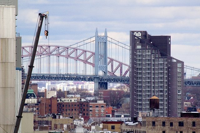
Shades of “Arkham Asylum” on Wards Island (from the Batman mythology) notwithstanding, Triborough – along with the Hell Gate Bridge – is the backdrop to life here in Astoria. Due to the rapacious real estate development currently underway in western Queens, this won’t last for long as residential towers continue to rise all along the waterfront. The view above is from the Queensboro Bridge, incidentally, looking north.
from omh.state.ny.us
Kirby Forensic Psychiatric Center, a maximum security hospital of the New York State Office of Mental Health (OMH), opened in 1985 and provides secure treatment and evaluation for the forensic patients and courts of New York City and Long Island. Most patients are received through the courts under Criminal Procedure Law (CPL) or through the OMH Commissioner’s office via the New York State Code of Rules and Regulations (NYSCRR) regarding hospitalization of the mentally ill.
Treatment is provided in accordance with the current standards of professional care outlined by the Joint Commission of Accreditation of Health Organizations (JCAHO) and is carried out with respect for each patient’s privacy and rights, in agreement with his/her level of functioning and need for security. KFPC has an active staff education program as well as academic affiliations with several metropolitan area colleges and universities, to help assure quality treatment and state of the art care.
and from wikipedia
The Manhattan Psychiatric Center is a New York-state run psychiatric hospital on 125th Street on Ward’s Island in New York City. As of 2009 it had 509 beds. The current building is 14-stories tall.
The hospital’s roots date to 1848 when Ward’s Island was designated the reception area for immigrants. Some additional structures were originally part of Blackwell’s Island Lunatic Asylum, which opened around 1863.
The building was significantly enlarged in 1871, and a Kirkbride Plan style building was built. After the immigration entry shifted to Ellis Island in 1892 the state took it over from Manhattan in 1899 and expanded it even further. At the time, it had 4,400 beds and was the largest psychiatric hospital in the world.
At the time it was one of two psychiatric hospitals for residents of Manhattan that had been take over by the state. The other psychiatric hospital would become the Central Islip Psychiatric Center in Central Islip, New York. Both hospitals were referred to as Manhattan State Hospital.
It later became the Manhattan Psychiatric Center. The facility is currently run by the New York State Office of Mental Health.
– photo by Mitch Waxman
As a rule, I don’t use the modern appellations for Queensboro (Ed Koch) and Triborough (Robert F. Kennedy). I will, once the Brooklyn Bridge is renamed for Michael Bloomberg or Chuck Schumer.
Happy 80th, mighty Triborough.
Upcoming Events and Tours
Tuesday, July 12, 7:00 p.m. – 10:00 p.m. –
LICHenge, with Atlas Obscura and the
Hunters Point Park Conservancy. Click here for more details.
Saturday, July 16, 11:15 a.m. – 12:45 p.m. –
FREE Newtown Creek Boat Tour,
with Waterfront Alliance (note- WA usually releases tix in batches).
Click here for more details.
Saturday, July 23, 11:00 a.m. – 1:00 p.m. –
Calvary Cemetery Walking tour,
with Brooklyn Brainery. Click here for more details.
Tuesday, July 26, 6:30 p.m. – 8:30 p.m. –
Glittering Realms Walking tour,
with NYC H2O. Click here for more details.
Wednesday, July 27, 1st trip – 4:50 p.m. 2nd trip – 6:50 p.m. –
2 Newtown Creek Boat Tours,
with Open House NY. Click here for more details.
“follow” me on Twitter- @newtownpentacle
explosive circumstance
Who can guess, all there is… BOOOOOMF… Holy Crap!

– photo by Mitch Waxman
My plan for today’s post was originally going to involve fireworks, of the 4th of July variety. Wednesday night at about Midnight, however, my corner suddenly exploded. It seems that the patch job Consoldiated Edison performed in Astoria after the Great Astoria Blackout of 2006 is beginning to get a bit long in the tooth.
After a blast of bluish flame, yellow brown smoke and orange fire began to shoot out of the manhole.

– photo by Mitch Waxman
As mentioned in another post earlier this week, I’m the one who – when he “sees something,” then “says something” so I called 911 with one hand while reaching for my DSLR camera with the other.

– photo by Mitch Waxman
This all happened right around midnight, and at about five minutes past, the next block – specifically 44th street between Broadway and 34th avenue – went dark. Even the street lights went out.

– photo by Mitch Waxman
In NYC, when an emergency strikes, you want God on your side. When the FDNY gets there, God can move on to other things – as they can handle most things. Several FDNY units arrived, and set up a cordon around the burning transformer.

– photo by Mitch Waxman
The fire guys began knocking on doors and inspecting basements for carbon dioxide build ups, and there were a bunch of them sticking probes into the sewers and unaffected manholes.

– photo by Mitch Waxman
Safety tape went up just as NYPD arrived, who took charge of redirecting traffic from FDNY and began answering questions from the residents of the affected block. Before you ask, I wasn’t affected, which was very lucky.

– photo by Mitch Waxman
After about an hour and a half, a Con Ed Emergency truck arrived with two guys in it. They began to assess things and the fire guys started getting ready to leave the scene. The manhole was still smoldering, but it was only emanating a trickle of white vapor by now.

– photo by Mitch Waxman
The Con Ed guys opened the street, and then more of them began to arrive.
When I woke up Thursday morning, there was an army of them at work down there, rewiring and rekajiggering. There was also a giant pile of media trucks. WABC was here, so was NY1, and Channel 11 too.

– photo by Mitch Waxman
The shot above is actually the sort of thing which was intended for today, but… as I often say…
Who can guess, all there is, that might be buried down there?
Upcoming Events and Tours
Tuesday, July 12, 7:00 p.m. – 10:00 p.m. –
LICHenge, with Atlas Obscura and the
Hunters Point Park Conservancy. Click here for more details.
Saturday, July 16, 11:15 a.m. – 12:45 p.m. –
FREE Newtown Creek Boat Tour,
with Waterfront Alliance (note- WA usually releases tix in batches).
Click here for more details.
Saturday, July 23, 11:00 a.m. – 1:00 p.m. –
Calvary Cemetery Walking tour,
with Brooklyn Brainery. Click here for more details.
Tuesday, July 26, 6:30 p.m. – 8:30 p.m. –
DUPBO Walking tour,
with NYC H2O. Click here for more details.
Wednesday, July 27, 1st trip – 4:50 p.m. 2nd trip – 6:50 p.m. –
2 Newtown Creek Boat Tours,
with Open House NY. Click here for more details.
“follow” me on Twitter- @newtownpentacle
afar off
The sky is stolen, so repent… or just rent…

– photo by Mitch Waxman
The cabal of entrepreneurs and bankers whom one has long referred to as the “real estate industrial complex” has been quite busy in the eastern side of Long Island City for the last few years. The sky has almost been entirely blotted out, and thousands of new apartment units constructed, usually atop brown fields and former industrial sites. This shot is from the Thompson Avenue Viaduct adjoining Court Square, and as you can see – this section of Queens has been recast in Manhattan’s image.
Unlike Manhattan, of course, there are no new hospital beds or any of the other things which you’d normally expect to find in an area being built up for a large residential population. Lately, the word “Brasilia” comes to mind when I’m walking around the modern corridor of LIC.

– photo by Mitch Waxman
As mentioned last week, rumors abound in LIC that the Real Estate Industrial complex is pushing for a rezoning of the industrial corridor that runs from the Pulaski Bridge to Greenpoint Avenue, between Newtown Creek and the Sunnyside Yards/Long Island Expressway. Spotted recently on the intersection of Greenpoint Avenue and the Long Island Expressway was the sign above. This signage indicates many things to me about the sort of people who are actually driving this train, who they are, and where the money behind it all is likely coming from.
Formerly, signage observed nailed to this utility pole has included the ubiquitous “Cash for Cars” and “Stop Bedbugs” illegal postings which plague western Queens.

– photo by Mitch Waxman
Back in Astoria, we still haven’t been lucky enough to receive much attention from these folks, which is good news. We can still see the sky, and when a rainbow appears over Jackson Heights to the east – it’s still a source of wonder for all the neighbors to marvel over.
Incidentally, conversation over the weekend with one of my cousins indicated that you can still find housing that is quite affordable in the Mill Basin/Canarsie area, and that the sky and sun haven’t been co-opted by co-ops.
Upcoming Events and Tours
Tuesday, July 12, 7:00 p.m. – 10:00 p.m. –
LICHenge, with Atlas Obscura and the
Hunters Point Park Conservancy. Click here for more details.
Saturday, July 16, 11:15 a.m. – 12:45 p.m. –
FREE Newtown Creek Boat Tour,
with Waterfront Alliance (note- WA usually releases tix in batches).
Click here for more details.
Saturday, July 23, 11:00 a.m. – 1:00 p.m. –
Calvary Cemetery Walking tour,
with Brooklyn Brainery. Click here for more details.
Tuesday, July 26, 6:30 p.m. – 8:30 p.m. –
DUPBO Walking tour,
with NYC H2O. Click here for more details.
Wednesday, July 27, 1st trip – 4:50 p.m. 2nd trip – 6:50 p.m. –
2 Newtown Creek Boat Tours,
with Open House NY. Click here for more details.
“follow” me on Twitter- @newtownpentacle


