Archive for the ‘Hunters Point’ Category
Like every other bit of wind blown trash…
Tuesday
– photo by Mitch Waxman
After transmuting from upstate to midtown Manhattan via the MTA’s Metro North operation, your humble narrator then negotiated his way to the 42nd street 7 Line station.
Now, you may be wondering: Hey Mitch, what with that broken ankle PTSD that pops up when you’re descending steps, that you are constantly mentioning and complaining about, how was it negotiating the subway system with all of those flights of stairs?
The answer is ‘wasn’t all that simple.’ I was the slow moving old guy on the stairs, the one whose hand was floating a half inch over the bannister and carefully working his way down at his own speed.
– photo by Mitch Waxman
The PTSD mishegoss is retreating, due to all of the exposure I’ve been inflicting on myself back in Pittsburgh with its ‘City Steps.’ Saying all that, it’s still there, and it sucks. There’s a background ‘gotta be careful here’ thought pattern as I approach the top of a flight of stairs, but it’s almost always the initial ‘top’ of the steps where my brain starts firing bolts of panic. Badly broke my ankle on a set of steps at home, of all places, and ever since this has been a bit of a ‘thing’ for me whenever I’m confronted with stairs. Bah!
At any rate, the 7 carried me where I was going in air conditioned comfort. It was going to be a super hot and humid day, weather wise. In fact, the rest of my time in NYC was going to be defined by ‘swamp ass’ humidity and high temperatures.
My grandmother always used to tell me that we were put of this earth to suffer.
– photo by Mitch Waxman
Hunters Point, in Queens’ Long Island City. I sort of expected some thunder or something when I stepped onto the sidewalk, but it was actually sort of anti climactic. This is one of the places I was thinking about while sitting in that wheelchair at the end of last year.
I had arranged with my pals at Newtown Creek Alliance to meet up with a couple of the ‘new guys,’ and take a walk with them.
– photo by Mitch Waxman
Long Island Railroad’s Hunters Point yard has been getting upgraded with a flood wall while I was gone. With the alterations to this spot they’ve operated out of since 1868, this wall would count as version 10 of the station, in my eyes. Once upon a time, there was a giant steel and glass train station here which fed into a ferry terminal, a structure reminiscent of the sort of station sheds you see in Europe. There was a railroad turntable… they had all the toys. Nowadays, MTA is trying to figure out the finances for decking this rail yard over so that yet another condo tower can be built on top of it.
Regarding the title of today’s post, it’s a part of my ‘bluster’ from the Newtown Creek years. When interviewed by press people and asked about how I found myself studying the creek, I’d offer: Desolate, disabused, discarded… soon, like every other piece of wind blown trash in NYC, I ended up at the Newtown Creek. I’d often get a raised eyebrow from any politicians in the room when saying this phrase.
– photo by Mitch Waxman
Inhuman. That’s what I always say to myself when I see these sorts of structures. Anti-democratic, as well. I don’t mean the political party.
The very nature of this sort of residential setup divides people into ‘haves’ and ‘have not’s.’ Twenty to thirty years in the future will prove me out on the consequences of this development philosophy. Same thing applies to Manhattan’s Abomination Hudson Yards. Bah!
It was already quite warm and humid out. Luckily, before leaving Cold Spring upstate, I ate a very solid breakfast and inhaled about a gallon of coffee and water. The ankle was a bit ornery from the efforts of the prior day, but holding up to the mission. No pain, at all.
– photo by Mitch Waxman
Finally. It had been nine months almost to the day since I tumbled down a set of steps in my house in Pittsburgh, busted my ankle and also dislocated my left foot.
Hospitalization, surgery, two months in a wheelchair, endless months of physical therapy and omnipresent pain, months and months of walking up and down hills in Pittsburgh to get my strength back… and there it was: Newtown Creek sitting right in front of me.
Tingles, I tell you, I felt tingles. The ankle story was actually ending. I had finally made it through this crucible.
Truth be told, a clap of thunder would really have been appreciated as I approached her, but that’s just me wishing for theatrics.
Back tomorrow.
“follow” me on Twitter- @newtownpentacle
Buy a book!
“In the Shadows at Newtown Creek,” an 88 page softcover 8.5×11 magazine format photo book by Mitch Waxman, is now on sale at blurb.com for $30.
less than
Another day, another bridge across Newtown Creek.

– photo by Mitch Waxman
There are five bridges crossing the Dutch Kills tributary of that lugubrious ribbon of urban delight called the Newtown Creek, here in Long Island City. You’ve got two movable railroad bridges, the retractile Borden Avenue Bridge, the high flying truss which carries the Long Island Expressway and then slopes down into the Queens Midtown Tunnel, and the good old Hunters Point Avenue Bridge. There’s been a bridge of one kind or another here since about ten to twenty years after the Civil War, with one notable span made of wood whose opening and closing was powered by ropes and a donkey. The current bridge was installed in 1910, when Michael Degnon was building his industrial terminal around Dutch Kills, and the Pennsylvania Railroad was finishing up their construction of the Sunnyside Yards.The Hunters Point Avenue Bridge was originally a double bascule drawbridge, but back in the 1980’s, the City rebuilt the roadway and replaced the mechanism with a single bascule version, which is the one featured in today’s post.
Apparently, Hurricane Sandy did quite a job in the electrical equipment that operates the thing, and since the City is required by the United States Coast Guard to maintain the HPA Bridge as a movable structure there’s been folks working “down below” in the gears and gizmos of the thing. It’s on one of my main routes when I’m out for a walk.

– photo by Mitch Waxman
The other night, Dutch Kills was frozen into a giant plate of ice. This isn’t surprising, since the hydrology of the canal displays very little in the way of laminar or horizontal flow. The water rises and falls with the tide, obviously, but the shapes and angles of the bulkheads in addition to zero sources of flowing water at its terminus other than a couple of open sewers cause the waters of Dutch Kills to mimic the behaviors of a stagnant lake rather than a flowing creek.
A few years ago, I started reading up on hydrology and talked to some of the powers that be about using “shaped” concrete forms to cause zones of compression and expansion which would passively move the water around a bit, but nothing really came of it. I still think this sort of engineering is the way to go, however. As I understand the concept, rounded shapes act as “brakes” in fluid systems, whereas narrowing the width and obliquing the angle of channel walls causes water to flow (think river rapids). Essentially, large bodies of water can’t rise that much above the level of surrounding water bodies they’re connected to, so when the volume hits a point of compression it gets “squeezed” and pressurized which causes it to begin moving towards a point where it can expand again. As an example, the same water pressure in your kitchen faucet is what feeds into your garden hose, with the only difference between the wildly dissimilar behavior of the same water pressure being that the stuff in the hose has been compressed all the way through the nozzle and the sink faucet flow can just expand into the basin.
Design in enough points of compression and expansion, you’ve got “flow.” Or at least, that’s my theory. What do I know, I’m a schmuck with a camera, not an engineer.

– photo by Mitch Waxman
Another hypothesis I can offer is that the Newtown Creek is far more biologically active at night than it is during the daytime. All the time I’ve spent around the waterway in the last year at night has revealed an otherwise hidden world that comes out in the dark. There’s higher mammals, both feral cats and raccoons, which are occupying the predator and scavenger niches. You can see and hear vast numbers of fish splashing around in the water, and there’s all sorts of critters crashing around at the littoral edges and along the bulkheads.
The shots in today’s post were exposures of about thirty seconds, so you won’t see what I saw when shooting them unless it held stock still for that interval of time. What I saw was a big fat raccoon foraging around at the water’s edge, scooping up shell fish and other horrible wriggly things to eat for dinner. Actually, it was probably for breakfast, as the trash pandas are nocturnal – just like me.
“follow” me on Twitter- @newtownpentacle
disproportionate orders
What if peace broke out?

– photo by Mitch Waxman
Given my love of hatred and conflict, it’s an odd thing that I found myself at the East River last weekend to attend a solemnified ceremony led by an international team of Spitiual Industrial Complex employees and sky father worshippers devoted to “peace.” Additionally, since my entire spiritual path and moral compass is built around the “Adventures of Superman,” the only way to achieve a lasting peace on this planet might just be the presence of an extraterrestrial savior possessed of powers and abilities greater than those of any ordinary man. Disguised as one of us, and working at a great metropolitan newspaper… well, you know the rest – leaping tall buildings, mighty rivers, locomotives. Truth, Justice, and the “American Way.”
The American Way ain’t peace.

– photo by Mitch Waxman
Saying that, there are others out there who live in a more hopeful stat of awareness, and work towards achieving a goal which I’m convinced you’d need laser vision and the ability to walk across the surface of the sun unscathed to do. They gathered last weekend in Gantry Plaza State Park to meditate, and speak in public, sharing their points of view and offering curative advice to halt the epic suffering of their fellow humans by causing a cessation of armed conflict and violence.
To this end, they inscribed prayers and other missives on a series of floatable lanterns. Some of my friends were driving the kayaks which hauled the things into position.

– photo by Mitch Waxman
Apparently, this is an annual event, one which my friend Erik Baard is centrally involved with. Erik is a deeply annoying friend, I would mention, as he sets forward examples in his lifestyle, politics, and behavior that few can actually measure up to. Many people in the environmental community “talk the talk,” but few “walk the walk.” They’ll yell and scream about oil and the modern world in a meeting, then get into an SUV and drive into Manhattan. Not this bloke.
I know three, maybe four, of the “real things” and it’s important to acknowledge them when they’re around.

– photo by Mitch Waxman
So, Erik and his group of paddlers hauled the lanterns out and affixed them to a wire of something anchored on the bottom of the East River. I started getting bored at this point, and decided to play around with the camera a little bit.
Me? I ain’t the real thing, I’m just some schmuck with a camera.

– photo by Mitch Waxman
I set the thing up for some longish exposures, about thirty seconds each. Luckily, the displacement waves from passing NYC Ferries were splashing in and around the rip rap shoreline.
Technically speaking, this isn’t Gantry Plaza State Park’s shoreline, it’s NYC’s Hunters Point South Park.

– photo by Mitch Waxman
So, that’s what I did on Sunday night.
TLDR; Peace lanterns, musing about Superman, pictures.
“follow” me on Twitter- @newtownpentacle
quickened force
Cuckoo for Cocoa Puffs, me.

– photo by Mitch Waxman
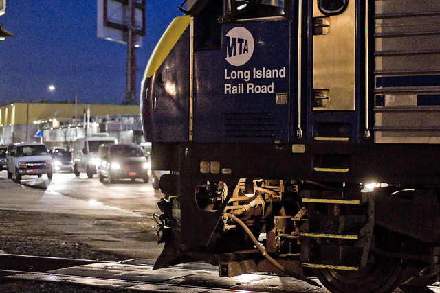
Towards the end of last week, a humble narrator found himself over in the Shining City of Manhattan. I had business to discuss with somebody, mainly creating a new walking tour route, and we actually stomped out one of my proposed routes (Wall Street to 23rd street via the “East River Greenway”) after which one found himself at the NYC Ferry dock at 34th street. A quick journey across the river to Long Island City, as the burning thermonuclear eye of God itself slipped behind New Jersey, soon found me scuttling about in a Long Island City which was cloaked in preternatural darkness.
The tripod was deployed and a humble narrator got busy with the camera, which seemingly generated much interest for both private security personnel and ordinary passerby. Click, whir, click. That’s a LIRR train idling at the Hunters Point Avenue station, if you’re curious.

– photo by Mitch Waxman
The crap hole security fencing around the Sunnyside Yards doesn’t do much to actually secure the railyard, but it does get in the way of your shots. In many ways it’s a metaphor for the entire MTA. Pictured above is a long exposure of the 7 line subway exiting the Hunters Point Avenue station, and climbing onto its elevated course towards the next stop – which is the Court Square station.

– photo by Mitch Waxman
Another long exposure shot, this time from the 54th avenue footbridge over the tracks, looking westwards towards the Pulaski Bridge and the Queens Midtown tunnel. I would have waited for a train to roll by, but on my way to this spot, two LIRR units had just transited by (see below). Like a lot of the shots recently presented here, this is a narrow aperture and low ISO sensitivity photo with an exposure time of about thirty seconds.
That’s where all those light trails come from.

– photo by Mitch Waxman
I was on Borden Avenue, and heading for the 54th avenue footbridge, when the signal arms came down and the parade of LIRR rolling stock began. As a note, the shots above and below are handheld exposures, unlike the ones above.
One thing about all this night shoot stuff I’ve been up to lately is the need to be able to switch back and forth between the two strategies utilized for low light shots. In the case of these passing trains, I wanted to “freeze” the moment, so they are wide aperture and high ISO shots representing about 1/200th of a second, give or take.

– photo by Mitch Waxman
Proponents of the proposed “BQX” trolley line really should spend some time on Borden Avenue at rush hour to observe what an “at grade” crossing looks like on a well trafficked arterial street. Vehicle traffic backs up for blocks and blocks, and any traffic lanes which might intersect with the arterial begin to feel the effect of it within minutes.
As Robert Moses might have opined, it’s not about about the traffic, it’s about the flow.
– photo by Mitch Waxman
The tracks which the LIRR units are heading onto in this series are the ones you saw in the tripod shot from the 54th avenue footbridge. They lead into the Sunnyside Yards and the trains are going to be heading eastwards, I’m told, towards first Woodside and then Jamaica and then out to Nassau and Suffolk Counties.

– photo by Mitch Waxman
After unit 414 completed its journey past Borden Avenue, number 420 began its own trip. A humble narrator was squealing with glee, as a note, because simple things make me happy. After a day spent in Manhattan, which has become the most boring place on Earth, LIC welcomed me home with this grand parade?
I missed you too, Queens.
“follow” me on Twitter- @newtownpentacle
cannot give
Another set of shots from the Newtown Creek frozone.

– photo by Mitch Waxman
Last week I showed you what it looks like when Brooklyn’s English Kills freezes over, today it’s the polar paradise which Dutch Kills in LIC became after that recent spell of super cold weather that’s in focus. Both waterways are tributaries of the fabulous Newtown Creek, and the “kills” bit is Old Dutch for “creek.” The English and Dutch parts of the names are meant to indicate where the various ethnicities of European settlers sited themselves.

– photo by Mitch Waxman
Dutch Kills, as we know it today, is a canalized post industrial waterway surrounded by stout factory and warehouse structures and crossed by multiple bridges, with the current shape of things dating back to the creation of the surrounding Degnon Terminal in the late nineteen-teens. It attained its modern characteristics by 1921, and the last big addition to Dutch Kills was the installation of the Midtown Tunnel and Long Island Expressway way back in 1940.
That’s the LIE, or at least the Queens Midtown Expressway section of the it, pictured above. Close to 90,000 vehicle trips a day pass over the water here, yet most people you meet say they have never heard of the Newtown Creek.

– photo by Mitch Waxman
Like English Kills in Bushwick, Dutch Kills here in LIC was contained nearly completely by a layer of plate ice when I visited it last Wednesday. The ice was already “rotting” as the air temperatures returned to seasonal norms, and the weak tidal action witnessed in Dutch Kills was breaking it into distinct floes.

– photo by Mitch Waxman
Just like English Kills, certain areas which have been observed as being highly biologically active due to the presence of sewage sediment mounds during warmer climes were fully melted and flowing. The status of those unknown things which slither and slide and slop about in the bottom sediments during these unfrozen times remains a mystery.
There are some things you really do not want to know, after all.

– photo by Mitch Waxman
Over on the Borden Avenue Bridge, just to the south of the vantage point in the previous shots – which is offered by the Hunters Point Avenue Bridge – the rot of the ice was a bit more pronounced. An analogous appearance vaguely reminiscent of an otherwise wholesome slice of Swiss Cheese came to mind.

– photo by Mitch Waxman
The structure pictured in the first shot of today’s post, as well as in the last one presented above, is called a “dolphin.” It’s rooted deeply in the substrata of Dutch Kills and constructed of creosoted lumber piles. The purpose of these things is to protect the movable bridges they adjoin from an allision, accidental contact with passing maritime traffic. If both the boat and bridge were moving it be a collision, allision is if a moving object strikes a stationary one.
For me, they provide essential design elements and focal points for the framing of photos at a frozen superfund site, hidden at the very center of New York City.
“follow” me on Twitter- @newtownpentacle


